Afternoon Roundup: Unsettled weather arrives

Today turned out to be another lovely day, with temperatures in the low to mid 80s, mostly sunny skies, and low humidity. However, the increase of thin, high clouds can often portend unsettled weather, as high and thin clouds tend to streak out ahead of storm systems.

High pressure which dominated this weekend is slowly moving offshore, and when combined with the rigorous disturbance that is producing severe weather in the Midwest, our winds will be turning towards the southeast — an onshore component — if they have not already. As this onshore flow continues to become more established, clouds and moisture will be on the increase tonight. Any showers, however, should hold off tonight or be very light and and isolated due to the best forcing to trigger lift and precipitation remaining to our west.

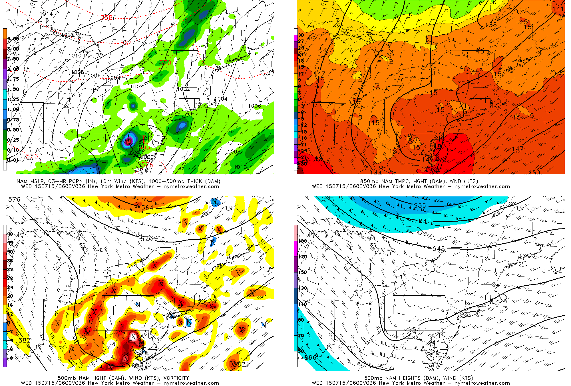
This disturbance finally will approach our area as the day goes on Tuesday. This will lead to mostly cloudy skies, more humid conditions, and the chance of an afternoon shower or thunderstorm. These storms will remain well below severe level, due to the greatest energy being far removed from our area, as well as the onshore flow limiting our instability.

General weather highlights include:

  • Increasing clouds tonight with overnight temperatures generally remaining in the upper 60s to low 70s. Any precipitation will most likely hold off.
  • Mostly cloudy skies tomorrow, but the morning and early-afternoon should remain dry. As the trough and associated disturbance finally moves closer to our area, the chance for rain and thunderstorms increases during the late-afternoon and particularly the evening hours. High temperatures will be in the low 80s, but it will feel noticeably more humid than it was today.
  • A warm front will be approaching late Tuesday night and early Wednesday morning, from the south. Along this warm front, a secondary area of low pressure from the initial system in the Midwest will be developing just to our south. This will cause more lift in the atmosphere, and when combined with the already moist airmass, could lead to showers and thunderstorms with locally heavy downpours and some loud thunder. The atmosphere will not be supporting severe thunderstorms with strong wind gusts, as the mid-level flow looks quite weak.
  • Wednesday looks quite unsettled, as this wave of low pressure will be causing showers and thunderstorms throughout the day.
  • Much more pleasant weather with low humidity returns on Thursday and Friday

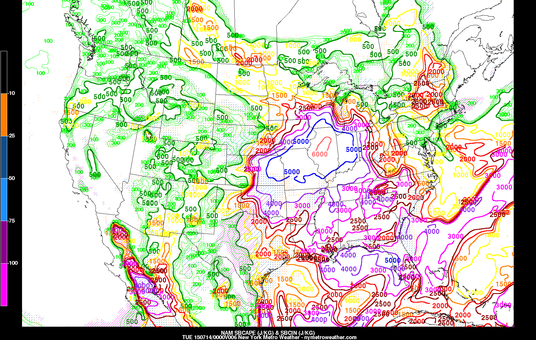
Something relatively rare in the meteorology community today: Surface-based CAPE values look to exceed 6,000 J/KG just southwest of Chicago. This is an extreme amount of energy and instability, which will be supportive of thunderstorms producing very large hail — perhaps some 2-3″ in diameter, 70mph wind gusts, and a few tornadoes.

Severe weather outbreak possible in the Midwest today

Severe weather season is kicking up, and today could feature a dangerous outbreak of storms over the Midwest and North/Eastern Plains states toward parts of the Mississippi River Valley. The Storm Prediction Center has issued a large “Moderate Risk” for severe thunderstorms in those areas, the second highest risk category they use (only High Risk denotes a greater potential), with the potential for widespread damaging wind gusts and strong tornadoes.

A large high pressure ridge, currently situated over the Central United States, is slowly shifting eastward. But, more notably, the high pressure dome is serving as a highway for severe thunderstorm formation on its northern edge. Along the periphery of the ridge, atmospheric disturbances have been sliding east and then southeast from the Northern Plains into the Mississippi Valley. These disturbances are acting to force thunderstorm development within an incredibly unstable and supportive environment for severe thunderstorms.

Read more

TS Claudette forms, expected to head seaward

Tropical Storm Claudette formed this afternoon, amid a noticeably quiet Atlantic Hurricane Season, to the south of Nantucket. Claudette had been monitored by the National Hurricane Center for the past several days as a potential disturbance, and today it obtained the tropical characteristics necessary to be classified as a Tropical Storm with maximum sustained winds over 45miles per horu.

The Tropical Storm won’t be a threat to any United States shores, however. A developing mid level atmospheric trough will act to steer the system seaward over the next 12 to 24 hours. At the same time, atmospheric shear will increase and the system will head toward cooler ocean waters. Subsequently, weakening is anticipated as Claudette moves northeast in the next 24 hours.

Read more

Morning Roundup: Changeable weather returns

The weekend hangover is real. Monday morning brings change to a weekend which featured a stretch of incredible summer weather. Highs topped out in the mid to upper 80’s each day, with an offshore flow and only some high clouds at times. The sun was shining for the majority of the time — with Saturday and Sunday both turning out to be winners. Monday, still, will remain generally pleasant. A few showers and storms may pop up late, but we aren’t expecting any threat for organized storms. The same can’t be said for the middle of the week, beginning on Tuesday. A deepening trough in the mid levels of the atmosphere will bring more moisture, the return of an onshore flow with clouds, and chances for showers and storms for the next few days. Some highlights from around the meteorological community are included below:

  • Pleasant and warm conditions will continue today, especially during the first half of the day. Highs in the 80’s are expected again and, initially, offshore winds will keep the weather pleasant. During the second half of the day, increasing clouds will be a harbinger of unsettled weather — with showers and storms possible.
  • A severe weather outbreak is possible today across the Central Mississippi Valley. A very impressive complex of thunderstorms broke out overnight with widespread severe winds, and moved through Chicago this morning. The storms will drop southeast and strengthen again today. These are forming along the northern edge of a heat ridge over the Central Plains.
  • An onshore flow will develop Monday Night with a changing wind direction. Increased moisture and cloud cover will move inland from the area waters. Temperatures, as a result, will be a bit cooler during the middle part of this week.
  • A coastal system may develop during the middle part of the week as a deepening trough moves into the Northeast US. Showers, clouds and storms will remain possible until the system departs later in the week.