-2")

Here’s Why the Warmth This December Has Been Historic
With the release of our Winter Forecast came the news that December was likely to average above normal in terms of temperature. Historically, almost all Strong El Nino events featured warmer than normal December’s in the Eastern US. The warmth this December, however, has been far more exceptional than anticipated. Temperatures have been well above average for almost all of the month. Multiple record highs have been broken in New Jersey and New York’s climate reporting stations. And, even still, a more anomalous warm surge is expected during the period of time near Christmas through New Years.
Currently, temperatures are running around 10 degrees above average. At this rate, extrapolating forward, December could average more than 5 degrees above normal. The meteorological reasoning behind this exceptional event features a juxtaposition of some very anomalous features:
1. Very Strong/Super El Nino
There is no doubt that El Nino is very strong and having a significant influence on the atmospheric. El Nino has slightly weakened since November, as as sub-surface cool pool of sea-surface temperature anomalies begins to migrate of the Western Pacific. Nevertheless, the El Nino remains very strong. Warmest sea-surface temperature anomalies have also shifted into eastern regions this month.

Sea-surface temperatures over equatorial Pacific since Oct 15th
These El Nino conditions have enhanced a deeper Gulf of Alaska trough with a firehouse pacific jet into the United States. In conjunction, the NAO (North Atlantic Oscillation) in the positive phase, has supported a very anomalous ridge to build over the Eastern United States and Canada.
2. Very Strong Stratospheric Polar Vortex
Temperatures in the stratosphere have been near record cold levels so far this Autumn. This has resulted in a very strong stratospheric polar vortex near the north pole. This often results in a more resilient polar vortex in the higher latitudes. Therefore, the coldest air remains locked in over Alaska and Siberia. For more cold air to work down into Eastern US, high pressure or a ridge needs to develop over the north pole, Alaska and Greenland and force the polar vortex south. This is what we commonly refer to as -AO/NAO/EPO or high-latitude blocking. Without blocking, a bigger ridge can form over Eastern US with unseasonably warm temperatures.

10 hPA temperatures near record levels in late November and early December (Image Credit: CPC)
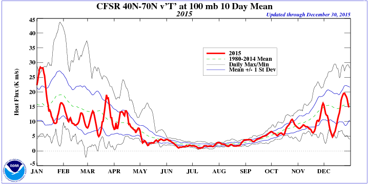
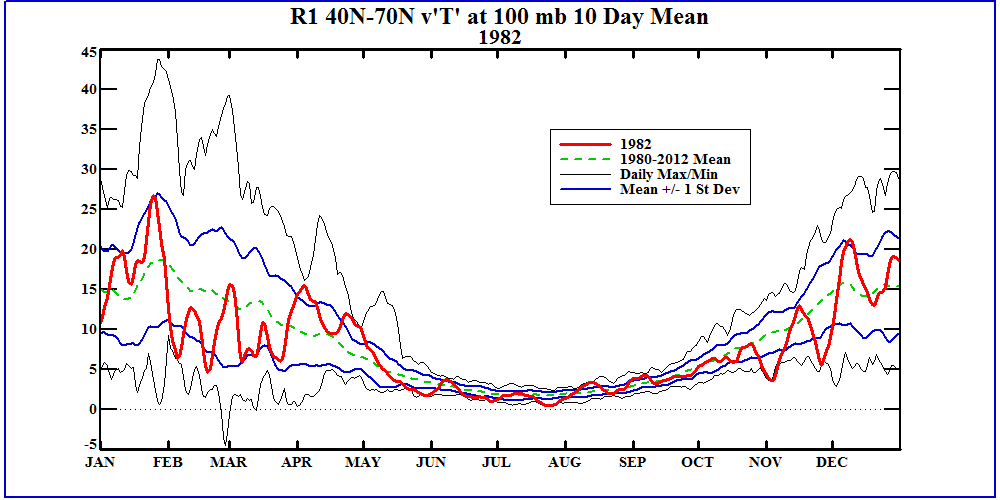
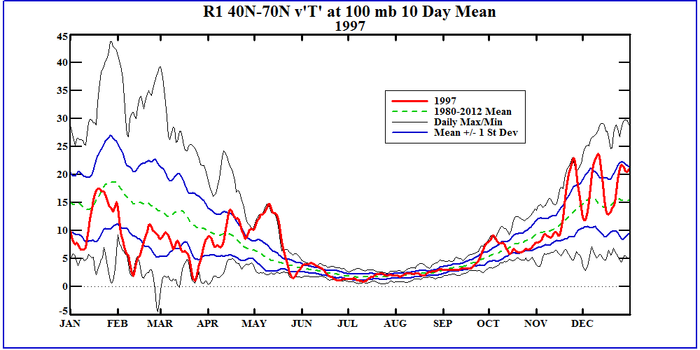
It is unusual to see such cold stratosphere during stronger El Nino winters. Heat flux at 100mb for this November and December has been well below normal. It has been running lower than the very strong/super El Ninos of 1982-83 and 1997-98, for the same period. Strong El Ninos often contribute to more heat flux in the atmosphere, that supports a relatively weaker stratospheric polar vortex during the winter. A comparison with the stratospheric polar vortex at 50mb for first 15 days of December shows that both 1982 and 1997 head weaker, more displaced stratospheric vortex’s compared to this year. Despite December 1982 and 1997 being warmer than average, some higher heights over the Gulf of Alaska region allowed for bursts of cold air to move into the Northeast US. This year, the stratospheric vortex is large and positioned directly over the pole — which is highly unfavorable for any cold air to move into our area.

Polar vortex at 50mb during first 15 days of December for 2015, 1982 and 1997
3. Warmest Phases of the Madden Jullian Oscillation
The Madden Jullian Oscillation (MJO) is convection that propagates from the Indian Ocean into the Tropical Pacific, that can have a significant influence on the atmospheric pattern over the Pacific Basin and North America. The MJO been active and in phases and 3 and 4 so far this month. It’s typically more dormant during strong El Nino, because sea-surface temperatures are cooler over the Indian Ocean or Western Pacific. However, warmer than average sea-surface temperatures in the Indian Ocean have caused more convection to develop in that region. While stronger convection more associated with the El nino has been near and east of the dateline:

30-day average OLR anomalies showing enhanced convection in Indian Ocean and near and east of the dateline
The MJO is forecast to strengthen and to continue to propagate through phase 4,5, and 6 for next 10 days or so. All these phases typically support warmer than normal temperatures over the Eastern US in December.

The MJO progressing in phases 3,4,5,6 for December. The graph on right showing temperature anomalies for the CONUS, during each phase.
While we acknowledged some uncertainties with the nature of stratosphere and the MJO back in our winter forecast, we didn’t quite anticipate to be near record cold levels in the stratosphere, or for the MJO to be this active. These features have supported even more well above average and record high temperatures.
All of this said, the forecast moving forward still seems very much on track. Our confidence continues to build in a changing pattern during middle to late January that will support increased chances of colder air and wintry precipitation. The extent of the warmth itself actually has very little impact on the forecast for January and February.
Trackbacks & Pingbacks
1procedures
Comments are closed.