-2")

(Premium) Record Breaking Cold Possible Sunday Morning… Another Storm Next Week?
A piece or lobe of the Polar Vortex will swing south over the Great Lakes and Northeast. This supports an Arctic front passing through Friday night. Some snow showers or snow squalls are possible again tomorrow night with this front. Behind this front will be a potentially historic cold airmass for parts of Northeast. Saturday will see temperatures fall from the lower 20s to teens and single digits during the afternoon hours. Winds will also be increasing, as wind gusts between 30mph to 40mph are possible during the day. Thus, windchills will drop to near or below zero and may approach dangerous levels by Saturday evening.
Model guidance shows 850mb temperatures as low -30C on Saturday night. Using a standard conversion from 850mb to the surface for nighttime lows, these 850mb temperatures would support widespread below zero temperatures — even for the immediate city and coast — as the NAM and ECMWF models suggest. However, the GFS keeps temperature in the single digits for the coastal areas late Saturday night, with the interior areas dropping to below zero.

The NAM (top image) showing widespread below zero temperatures early Sunday morning. The GFS (bottom image) showing temperatures in single digits over the coastal areas and below zero temperatures for the Interior areas (PSU E-Wall).
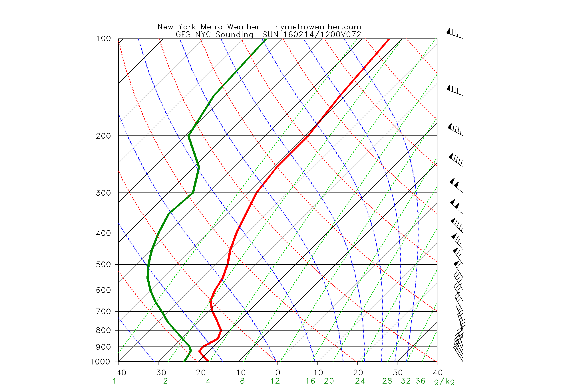
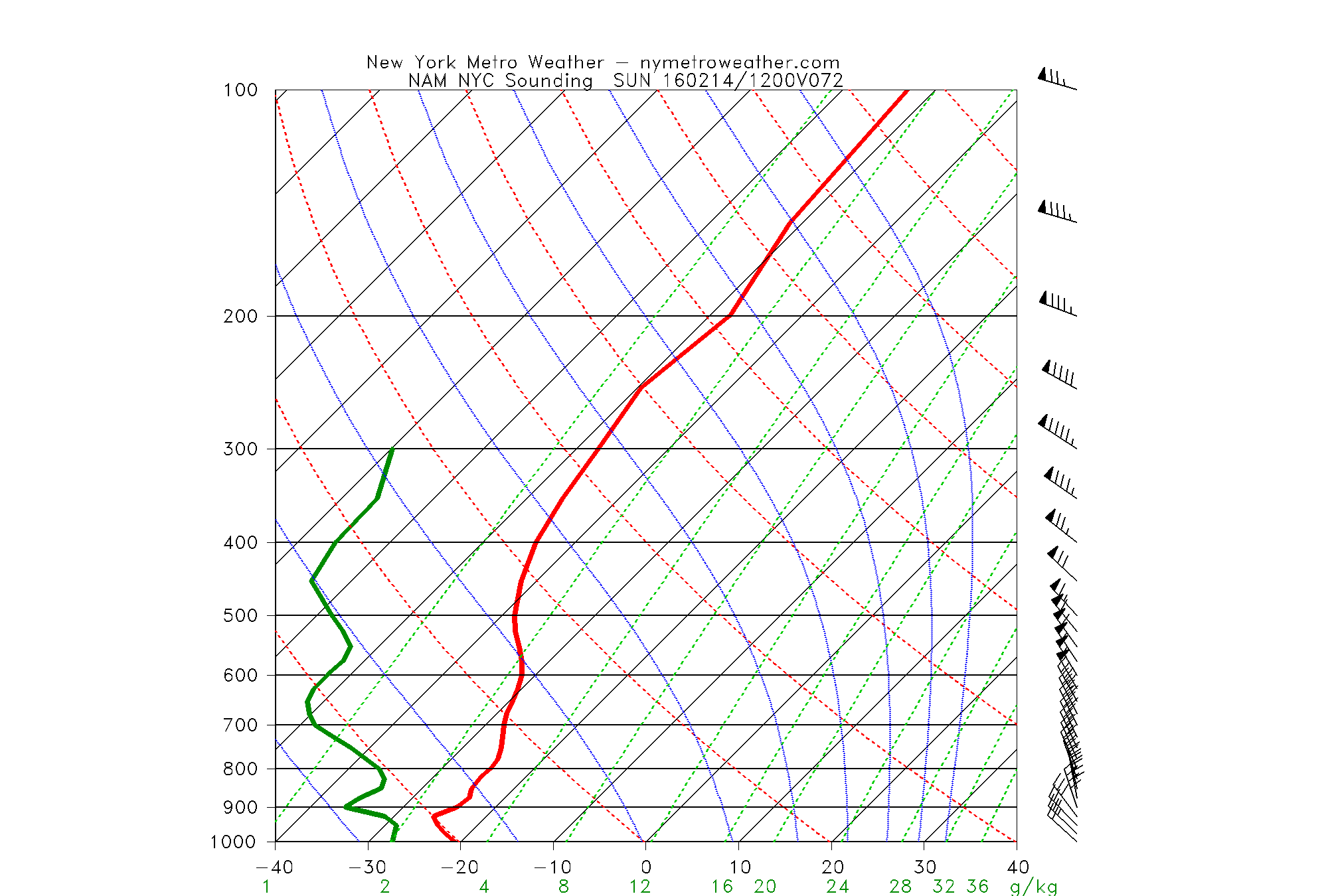
The GFS soundings are showing a deeper mixed layer, (look between 800 and 650mb) with gusty NW downsloping winds around NYC and coastal sections. This would allow for temperatures to drop into the upper single digits early in the night, and remain steady or slowly fall for most coastal locations, while higher elevations over Northern New Jersey and the Lower Hudson Valley would see temperatures continue to fall below zero. On the other hand, the NAM soundings show the mixed layer being much more stable, which allows much colder air to get wedged near the surface. Both scenarios are plausible. At this time, we think that temperatures will likely drop into the lower single digits over NYC and below zero for many of Interior suburbs. We will be close to breaking these record low temperatures for February 14th:
Central Park, NY: 2 (1916)
LaGuardia Airport, NY: 1 (1979)
JFK Airport, NY: 4 (1979)
Islip, NY: 7 (2015)
Newark, NJ: 0 (1979)
Bridgeport, NY: 3 (2015)
Regardless of these morning low temperatures, Sunday during the day looks frigid. Despite sunshine, 850mb temperatures still between -20C to -25C will only support high temperatures in the teens for most of the region. We might also come close to breaking record low maximum high temperatures for the day (list below). Winds will still be gusty throughout day, leading to windchills being near or below zero.
Central Park, NY: 17 (1979)
LaGuardia Airport, NY: 15 (1979)
JFK Airport, NY: 17 (1979)
Islip, NY: 26 (1987)
Newark, NJ: 15 (1979)
Bridgeport, NY: 18 (1979)
High pressure will start to shift east of the region on Sunday night. 850mb temperatures will rise to around -15C. This night will not quite be as frigid or windy as Saturday night. But lower winds will allow for more radiational cooling, particularly in suburbs. Low temperatures will be in the lower teens near the coast and single digits for the interior. Temperatures will continue moderate on Monday, as modest southwest flow begins developing. After a frigid morning, temperatures should rise into the lower 30s during the afternoon hours. However, skies will become mostly clouds as another storm system will developing over Southeast US. Warm air-advection well ahead of this storm could cause some light precipitation likely in form of snow to breakout by the evening hours.

The 12z GFS showing the 500mb trough going negative near Mid-Atlantic coast. Low pressure tracks over New Jersey with snow changing to rain in NYC metro region (PSU E-Wall).
A long-wave trough will be amplifying over the Eastern US. 500mb mean heights and positive anomalies rising over Western Atlantic and Southeast Canada suggest the trough could go very negatively tilted (SE to NW). This will cause the low to south track almost due north up the East Coast. More specific details on the track and intensity with impacts in our area will be determined over the next few days. However, with high pressure moving out into the West Atlantic and no Greenland block or 50/50 low, it is likely for the airmass to warm and a storm track to be further west over the region.
At this point, we have some snow starting sometime Monday then going over to wintry mix than rain for most areas by Tuesday morning. There is potential for more snowfall or wintry mix for the Interior Northeast and Mid-Atlantic, depending on the track of the storm. For the coastal plain, including the major cites like NYC, more heavy rainfall from this storm appears most likely given the pattern and model solutions, at this time. We will continue to monitor this system for any changes as we get closer.
This article was written and edited by Miguel Pierre and Doug Simonian.
Trackbacks & Pingbacks
1candelabra
Comments are closed.