-2")

AM All Zones Update: Clouds Today, More Rain by Tuesday, Another Storm Midweek?
Today will be mostly cloudy, as a weak frontal boundary moves through region. A few light snow showers, flurries or sprinkles are possible, during the day today. But these aren’t expected to amount to much, with warmer temperatures. Temperatures with southwesterly winds will be rising into upper 30s to near 40 over the Interior to lower to middle 40s today along the coast this afternoon.
High pressure begins build over the region, with drier northwest winds tonight. This lead clearing skies and overnight low temperatures in the middle 20s to lower 30s, from the interior to coastal areas. Tomorrow skies will be mostly sunny with high pressure in control. A slightly colder air mass form the north will keep upper 30s to lower 40s around the region tomorrow.
However, high pressure move offshore again tomorrow night. Clouds will being increasing ahead of the next storm system tracking into Great Lakes. Some rain could break out very late tomorrow night or early Tuesday morning, with a warm front approaching the southwest. Surface temperatures will hold steady or slowly rise overnight. But could be cold enough to support some pockets of freezing rain over the Interior.

The GFS showing areas of freezing rain with ice accretion over some of the highest elevations over the region.
Periods of rain, possibly heavy at times, will continue through much of the day on Tuesday, as low-level southwesterly jet strengthens. This will cause a warm front to push northward through region by late in the day. As better dynamics, shift north, rain begin tapering off to showers or drizzle, late in the afternoon and evening. Tuesday night and early Wednesday will be mild temperatures in 40s and 50s over the region.
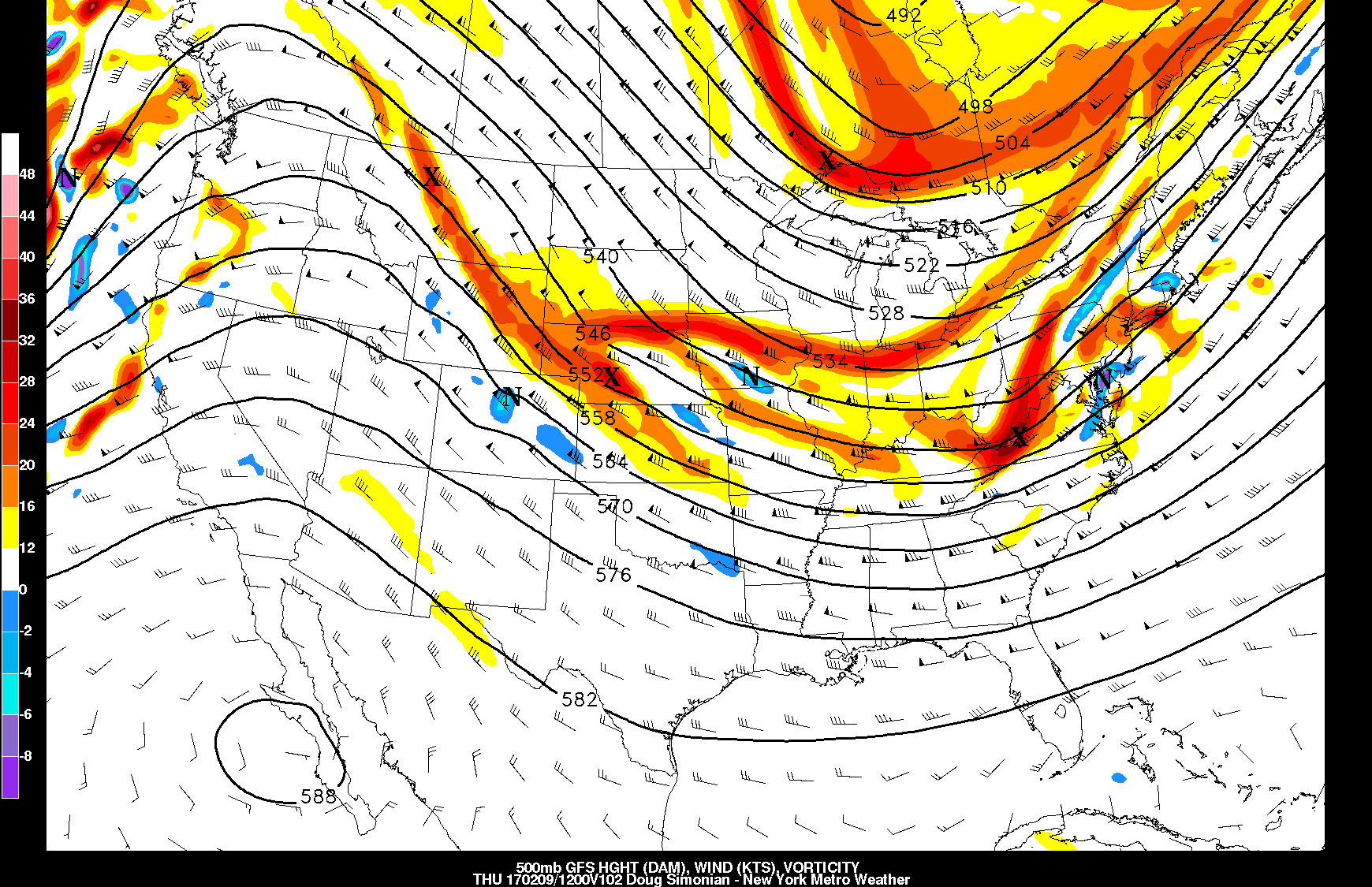
Then attention again, turns to a wave of low pressure developing along a cold front that will be coming through the region later Wednesday into Thursday. Latest GFS and ECMWF models overnight and early this morning, were further north with this wave again, as some shortwave energy inside larger trough, amplifies more before reaching the East Coast.
There is some ensemble support, especially from some of the GFS ensemble members early this morning. But guidance will have difficulty with timing and placement of features, without stronger high-latitude blocking on the Atlantic side. How much amplification occurs, near the East coast, will likely largely depend on the position and amplitude of a ridge moving into Western US during this period. If the ridge, well places over the Northern Rockies, there is better chance for shortwave energy to amplify and low pressure to track further north. A coupled-jet streak over the Northeast and Mid-Atlantic if shown on the models correctly, could also aid in more expansion of precipitation further north as well. .

6z GFS showing a wave low pressure further north on Thursday morning with 500mb shortwave energy amplifying and the local region sandwiched in between two jet streaks to north and south
At this time, we have sudden shift in some more reliable guidance. But we don’t have true trend between model cycles yet. So at this point, we will tread very carefully and wait for more run to run consistency on this system, before being bullish on it. Otherwise, some colder weather will likely return for Thursday and Friday, with the aforementioned ridge over the Western US, cause a larger trough over the Eastern US. Then temperatures may warm up again next weekend, as the pattern will likely remain somewhat progressive over the nation. Stay tuned for more zone forecast updates this week.