-2")

Public Analysis: Unusual Febuary Warmth, Unsettled Saturday
Another very warm end to the work week is on tap with temperatures leveling off on Saturday as a cold front moves through the region and provides a chance for some much needed precipitation for the area.
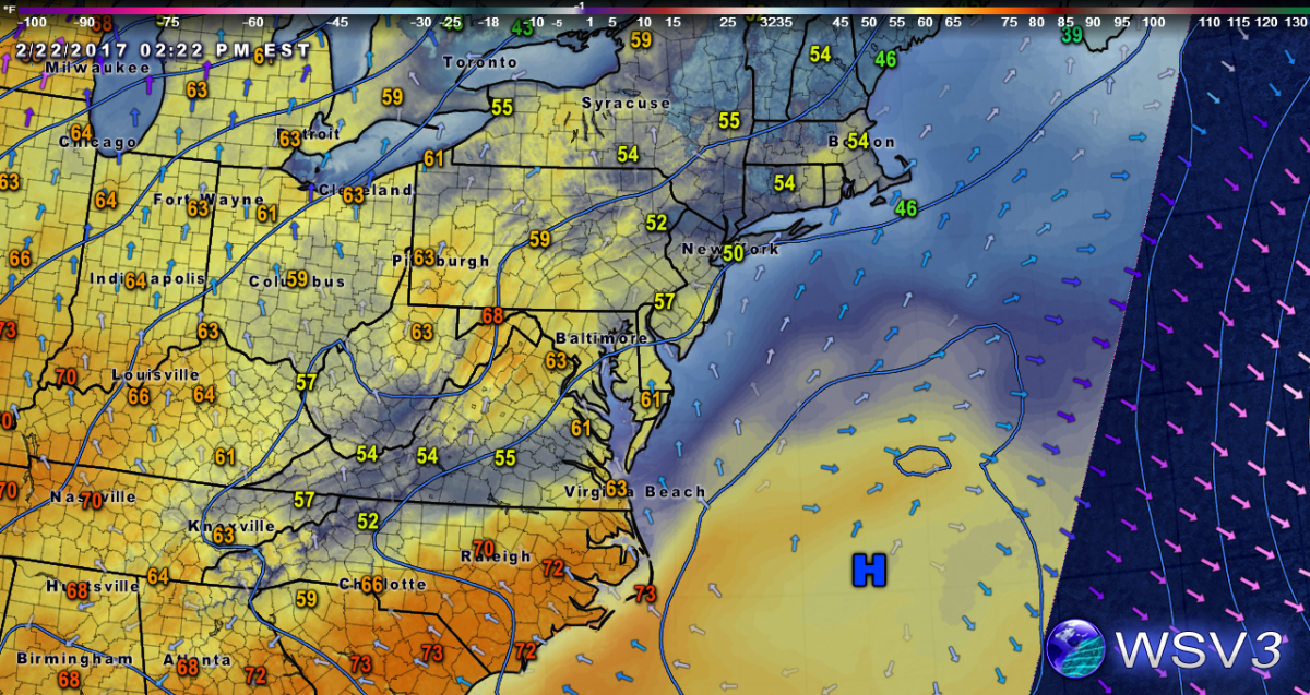
After some overcast and lingering sprinkles this morning that moved over the Lower Hudson Valley and Long Island, the associated overcast and showers have eased up enough to allow for temperatures to reach into the 50’s across much of the area this afternoon. With just middle to high level cloud cover persisting the rest of the afternoon, the Metro area should continue to see temperatures rise into the 50’s, with even some 60 degree readings possible in the southern half of New Jersey. As a very weak mid level disturbance dissipates while it quickly moves off to the east this evening, high pressure centered over the Atlantic will remain in control of our weather as we head into the evening and will help to provide a very light southerly flow. This southerly flow may introduce some moisture at the lower levels of the atmosphere very close to the surface that could produce areas of fog. The fog may reduce visibilities quite a bit in some locations, so use caution if driving. Otherwise, temperatures this evening will drop down into the 30’s for inland sections, and into the low to mid 40’s for the coastal areas which is just about average for this time of year.

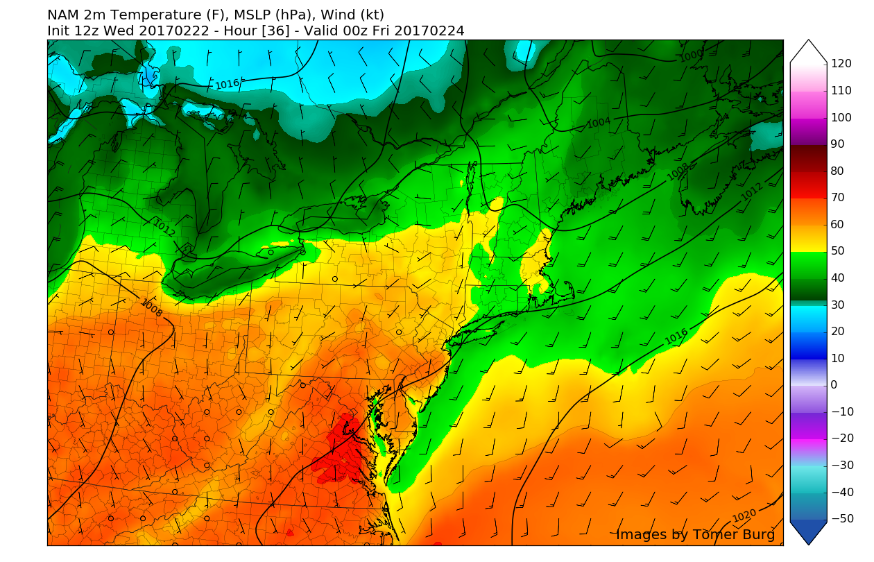
HRRR model showing reduced visibility conditions for tomorrow morning due to areas of fog (Valid 6am Thursday)
The big question for tomorrow will be just how long will the fog last tomorrow morning in addition to where will it be most prevalent. Current thinking is that the fog should have the most impact tomorrow morning along the coasts of NJ/LI/CT where cooler onshore flow combined with moist low levels will make it more difficult for residual fog to burn off. Outside of the coast, low level clouds should begin to burn off by early afternoon and allow for the sun to come out and work to really warm temperatures tomorrow to near record-high levels for some locations. Most of the area will see temperatures rise well into the 60’s with some locations seeing upper 60’s and possibly even into the low 70’s (especially southern locations).
As we head into Thursday evening, a warm front will overspread much of our area and provide more low level clouds and even some patchy drizzle with temperatures only dropping into the low-upper 50’s, which is incredibly mild for this time of year. Friday will be another questionable AM forecast with questions regarding how long the low level moisture and cloud cover can hang on and prevent warming of northern zones. Today’s model guidance diverges quite a bit regarding Friday afternoon, with the European model bringing the warm front well to our north, which sends temperatures into the upper 60’s and low 70’s for the entire area. Our other models are keeping cooler conditions, so current thinking is that due to the prolonged cloud cover, cooler temperatures seem to be possible on Friday from areas on north of Central New Jersey. with even some spotty showers and drizzle possible (especially if the warm front remains to our south).

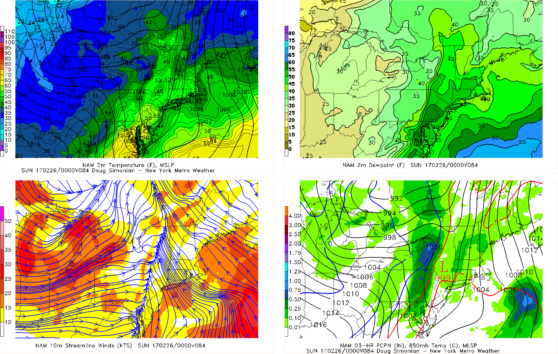
12z NAM showing the tight gradient near NYC where cloud cover and showers may linger on through the afternoon (Courtesy of Simuawips.com)
As we move onto this weekend, a weak area of high pressure will move to our north into the Canadian Maritimes on Saturday. The temperatures on Saturday will be highly dependant on just how far north the warm front can reach, and if it does happen to completely overspread our region, then highs in the 60’s and lower 70’s will be possible by the afternoon. As the day progresses, things will turn unsettled with increasing cloud cover by early Saturday evening as a cold front located in Pennsylvania heads east. Showers will be likely once we reach the evening hours, but due to the upward motion, strong upper level winds, and leftover moisture, there is a possibility that a line of shallow thunderstorms with heavy rain and lightning may pass through the area by late in the evening on Saturday associated with the cold front. Behind the front, Sunday will be much more seasonable than the previous few days and feature mostly clear skies throughout the day and continue as we head into the work week next week. Next week does look unsettled with the computer models diverging quite a bit on a potential storm system early next week that may bring a light wintry mix to the area. We will have more details on this potential system as well as any other new developments on Friday so make sure to stay tuned for any and all updates over the next few days! For more information and posts like this one, make sure you sign up for Zone Forecasts — where multiple detailed articles, videos, and interactives are posted each day.
Have a great evening!
Trackbacks & Pingbacks
2selected
Comments are closed.