-2")

2/28 Late AM All Zones Update: Mild Weather Continues, Severe T-Storm Threat Wednesday
Unseasonable mild weather continues today with a strong mid-level ridge over the region. A mixture of clouds and sunshine is expected to with temperatures warming into the upper 50s to lower 60s over much of the region this afternoon. Some parts of Central or Southern NJ may even reach the middle 60s. While some coastal locations might only rise into middle 50s with southerly winds off the water.
Clouds will increase and thicken again by this evening, as warm front and shortwave begins approaching the region. Increasing low-level moisture and weak lift may also lead to spotty light rain or drizzle could break out this evening. Then more showers and even a few isolated thunderstorms are possible overnight and tomorrow morning, as lift and instability increases with the warm front moving closer. Some areas of patchy fog may also develop, with more warm-air advection enhancing low-level inversion overnight.
After the warm lifts northward, clouds could break for more sunshine by the afternoon hours on Wednesday. If this occurs, temperatures will be approaching or exceeding 70 degrees, with deep southwesterly flow winds, especially away from the coast. Dewpoints also rising into upper 50s or lower 60s, will allow for the airmass to become more unstable for the beginning of March and setup

NAM model forecast for temperatures and dewpoints and winds late tomorrow afternoon
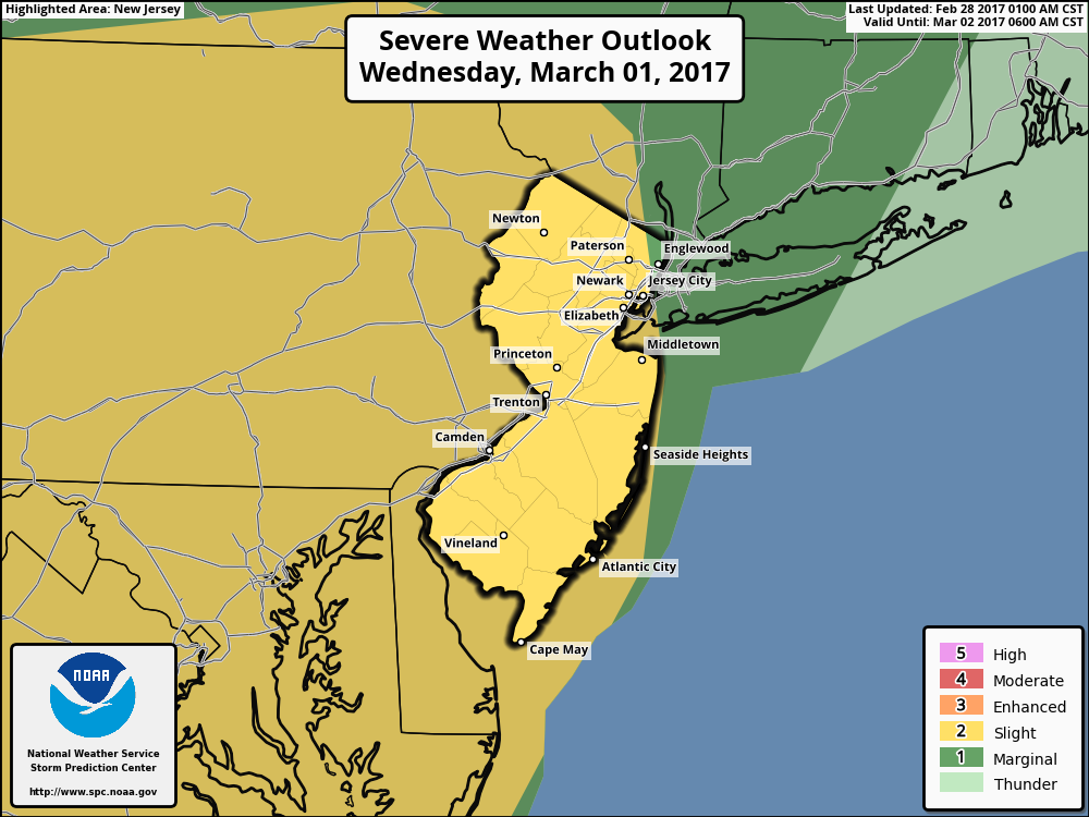
Then a pre-frontal trough with deep-layered shear could help trigger an organized cluster of strong to severe thunderstorms, later tomorrow afternoon and early evening. Model soundings indicate an EML (elevated mixed-layer) with modest mixed-layer CAPE and steep lapse rates will be over the region tomorrow afternoon. If this instability is realized will support any thunderstorms with stronger updrafts to produce some damaging wind gusts and large hail. Some directional shear with veering winds, may also lead to some isolated tornadoes, especially over Western New Jersey and Eastern Pennsylvania. For these reasons, the Storm Prediction Center has issued a slight risk for most of New Jersey and areas west of the Hudson River.
However, if some clouds or convective debris linger into the afternoon, this will result in less instability for severe thunderstorms. Also the better forcing still northwest with a strong upper-level jet and shortwave trough, could keep the region more capped underneath EML, thus supporting less widespread convection. Further northeast, especially over Long Island and Connecticut, more marine influence, could reduce instability for more severe thunderstorms. But some thunderstorms there could still be very strong with heavy rain, gusty winds, small hail and lightning.

NAM sounding over West-Central NJ tomorrow showing moderate instability and deep-layer shear with an EML
Then a cold front accompanied by the strong shortwave trough will move across the region later tomorrow night, with more showers and thunderstorms possible. More heavy rain, lightning and gusty winds are possible for the entire region. But these are likely to be far less intense, then any severe thunderstorms earlier, as instability diminishes after sunset.
More seasonably cold temperatures return later this week. More sunshine is likely on Thursday, with high pressure building into the region. But tight pressure gradient, behind the cold front will lead some strong northwest winds possibly gusting to over 40mph on Thursday. We are still watching a clipper with possibly light snow for Friday. Latest models have trended weaker and further south with this system this morning, as the shortwave energy is more sheared out. So only very minimal impacts are anticipated with this system at this time.
Stay tuned for more zone forecast updates this week, on severe weather threat Wednesday and possible clipper with light snow on Friday. Continue also checking on the main dashboard for more updates through the extended term.