-2")

FREE 3/12 AM All Zones Update: Blizzard Likely Late Monday Night and Tuesday
A very cold airmass with well below normal temperatures continues to be over the region over the next few days. Today (Sunday), some instability in the atmosphere will cause some clouds to mix with sunshine with a few flurries possible again. But winds are expected to be lighter out of the northwest. So it won’t feel as harsh as yesterday. Temperatures should rise into the upper 20s to lower 30s. Overnight lows tonight will be the single digits and lower to middle teens over the region, as high pressure sitting overhead and calming winds support ideal radiational cooling conditions. On Monday, high pressure over will support plenty of sunshine during the morning hours. Then more high clouds will start increasing during the afternoon from the southwest. High temperatures will be a little warmer in the low to mid 30s.
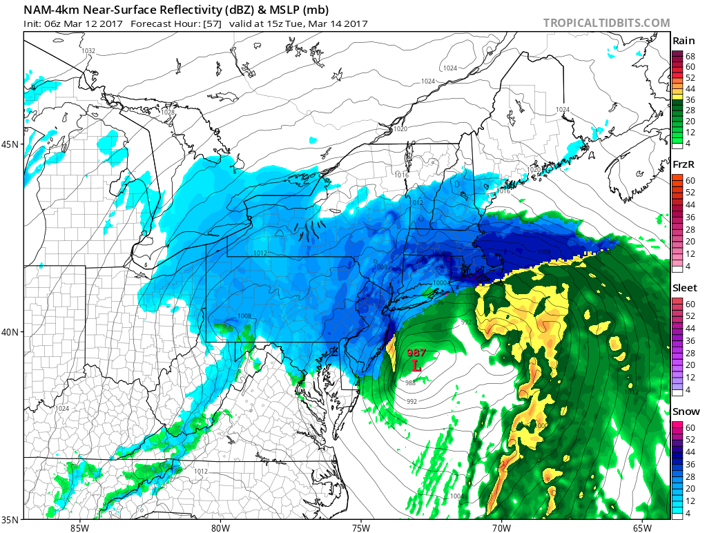
But most of the attention has already turned to a blizzard/Nor’Easter with very heavy snowfall and strong winds in the region on starting late Monday night into Tuesday, before winding down on Wednesday. The National Weather Service has already issued blizzard watches for New York City, Long Island, Southern New Jersey and Coastal Connecticut with Winter Storm Watches are issued elsewhere for this period. We currently believe there is a high risk for 1 to 2 feet (12″ to 24″) of snowfall for much of the region. There is even some risk for more than snow that in some areas, depending largely on the exact track of this storm, how banding sets up over the region, and any issues with sleet/rain mixing or snow growth, mainly closer to the coastline.

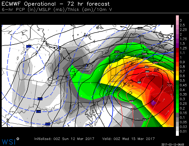
Overnight run of the ECMWF ensemble mean with 70%-90% probabilities over 12″ of snow from parts of New Jersey to Maine through early Thursday
After some variations during the day on Saturday, nearly all of the model and ensemble guidance overnight and early this morning showed more interaction and phasing between Polar and Pacific shortwave energy digging into the Plains and a subtropical shortwave lingering over the Gulf of Mexico. The Polar shortwave energy closed off into a upper-level low over the Great Lakes, while the Pacific and subtropical shortwaves phased more just off the Mid-Atlantic coast.
This separation still between some of these disturbances, along with the West Coast ridge axis over Northern Rockies, still lead to low pressure to track from near the Carolina and Virginia coasts to near the 40/70 benchmark. A coupled, upper-level jet streak supports the low pressure consolidating near the Delmarva coast and rapidly intensifying with expanding TROWAL (Trough of Warm-Air Aloft) and then CCB (cold-conveyor belt) to the north and west of the low track. This will support very heavy snow and blizzard conditions with strong frontogenesis and deformation banding over many parts of the region. In the February 13th, 2014 snowstorm, a similar TROWAL produced snowfall rates of 3-4″ per hour, and a similar result is likely in some spots with this storm.

The ECMWF model forecast 500mb vorticity showing a ridge axis over Northern Rockies and the closed upper-level low over the Great Lakes and pacific and subtropical energy phased just off the New Jersey coast.
This consensus of guidance is often most reliable at this range and is the solution we are currently thinking is mostly likely to occur. This solution would result in a major snowfall with blizzard conditions, as high pressure to the north enhances the pressure gradient for strong east-northeast winds, especially near the coast. There is the potential for sustained winds 20-30mph with gusts up to near 50mph over New York City, Long Island, Coastal Connecticut and Eastern New Jersey. Some isolated higher gust to near 60mph are also possible over Eastern Long Island. These winds also could lead to some coastal flooding during high tides on Tuesday, as we come off a full moon peaking on Sunday.
However, there is still some time, for some model variations on the handling how the aforementioned polar, pacific and subtropical shortwave energy interact and phase with each, that could to some changes in storm track and slightly lower snowfall totals in parts of the region. If the low shifts more further west inside closer to New Jersey coast, it will lead to easterly winds with warmer air intruding into lower to mid-levels of atmosphere, resulting in snow to mix or changing to sleet or rain, for at least a few hours during the height of the storm. This is mostly likely along immediate coastal sections, such as Eastern Long Island and Southeast NJ. Areas closer to I-95 or further inland would likely see enough cold to keeping mostly if not all snow, even in this scenario. Although, mid-level warming and drying may reduces snow growth for some areas as well, and also lead to some mixing with sleet.

6z GFS model today showing strong east-northeast winds impacting the coastline early Tuesday morning
On the other hand, if the low tracks a little further southeast of the 40/70 benchmark, this may result in the heaviest banding to move over eastern or coastal areas. Areas further inland, may see more subsidence resulting in less heavy banding. Nevertheless, even with small changes in the track, the storm will still be loaded with a lot of dynamic lift and Atlantic and Gulf moisture with and a subtropical jet feeding into this storm. So snowfall totals could be very significant (6″+) even in the eastern scenario. Some periods of snow or snow showers may also linger into Tuesday night and Wednesday with the upper-level low back over the Great Lakes swinging through the Northeast or Mid-Atlantic region.
This zone forecast update is free for all of our followers to read today who support us and desire more detailed or technical information on this major storm. Head over to our zone forecasts page for more information on signing up for more updates like this one. Then stay tuned for more zone forecast updates over the next few days on this storm. We will likely have another map with more details on snowfall totals and other impacts we expect around the entire region later this afternoon or evening.
Trackbacks & Pingbacks
1translation
Comments are closed.