-2")

3/16 All Zones Evening Update on Possible Snow this Weekend
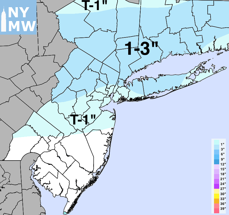
This is just a quick evening update on snow potential for this weekend. For Friday night and Saturday morning, not much has changed on model guidance today. After some sunshine most of day with highs in upper 30s to near 40, clouds will being increasing late tomorrow afternoon and evening. As an warm or occluded front approaches, Some light wintry mix of snow, sleet or rain may develop over parts of the region, later tomorrow night into Saturday morning. This is not expected amount too much for I-95 corridor or the coastal areas.
But today 12z run of the ECMWF model diverged significantly from continuity and other models today, with an inverted trough and coastal low developing off the Virginia coast on Saturday. The model showed more shortwave energy digging with further south into Mid-Atlantic, while the trough remains open with positive tilt. Thus more moisture and banding further south over Virginia and Delmarva. If this solution this correct, this means much of the area will little snowfall accumulation of entire system over the weekend. Perhaps a slushy 1″ or 2″ of snow for the Interior areas with initial warm-air advection precipitation late Friday night or Saturday.

12z ECMWF model today showing inverted trough mostly over Northern Virgina/Delmarva region Saturday night
However, the NAM, GFS and Canadian models still suggest with a stronger inverted trough with 500mb-700mb PVA (positive vorticity advection) stream northward up the Northern Mid-Atlantic coast to more extent. This will result in heavier banding and more dynamic cooling with stronger lift and instability, along the inverted trough by Saturday evening with light to possibly moderate snowfall accumulations over the region.
The models will likely struggle somewhat with this inverted/Norlun trough. These type of troughs are quite delicate with timing and with often only very narrow band of heavier snowfall accumulation, while other surrounding parts of region see very little or nothing. But there is potential for farther south or drier solution for the entire area. So at this time we aren’t making any changes to our preliminary snowfall total estimates, based on guidance this afternoon. We may update our predictions tomorrow. But uncertainty may still be high, especially if model guidance doesn’t agree.

The 12z ECMWF vs 18z NAM comparison at 6z (2am ET) Sunday. The NAM is further north than the ECMWF model with the PVA (positive vorticity advection) region associated with upper-level low
There is also an outside chance that the trough digs more and actually takes on more neutral to negative tilt before reach the coast. If that were to happen, we will see coastal low being pulled further northwest, and larger snowstorm impacting most of the region. At this time, none of the reliable guidance shows this occurring, however. It will more difficult for such an evolution to occur, with pattern featuring progressive ridge out West, and NW to SE oriented confluence zone over the Northeast US.
Otherwise, any snow is still expected to taper off from west to east across the region during the morning to early afternoon hours on Sunday. Then some clearing is likely later in the afternoon. Temperatures are still expected to stay below normal through the weekend. Overall pattern looks progressive next week, but also active with pacific disturbances running over CONUS. Stay tuned for another zone forecast update by late tomorrow morning, with an analysis on guidance overnight into early tomorrow morning.