-2")

Significant Severe Weather Threat for the Deep South Sunday
For several weeks now, we have been discussing the likelihood of an active pattern developing throughout the United States — in particular, the potential for severe weather. That pattern has finally arrived over the past several days, and another in a series of potential severe weather events is expected to unfold on Sunday across the South Central United States in parts of Texas and Louisiana on Sunday.
The potential for severe weather, while in a higher-end space than an “average” event, features considerable uncertainties even at this short range forecast juncture. We detail the intricacies of the setup and how we expect things to evolve on Sunday below.
An upper-level low will be moving from the Southwest United States and the Four Corners region into the Southern Plains this weekend. This will help to induce the development of a low pressure system along a dry line (boundary between dry and moist air) and frontal zone in the Plains States. The development of this low pressure area will aid in a warm and unstable airmass developing from the Gulf Coast into Texas and Louisiana, as warm and moist air is drawn northward. Showers and thunderstorms may begin developing by late morning as the moist airmass becomes established.
Ahead of the mentioned low pressure area, a strengthening south and southeasterly low level jet, or movement of air in the lower levels of the atmosphere, is expected to develop. Dew points in the 70’s will make for a tropical-like airmass and the atmosphere will become extremely unstable. As the sun shines and further destabilizes the atmosphere, lapse rates are expected to become increasingly supportive as well.

3km NAM showing dewpoints in the low to mid 70s ahead of dry line, over much Eastern Texas and Louisiana
While all of this is occurring, and the atmosphere is becoming unstable, strengthening winds in the low and mid levels of the atmosphere will move into Eastern Texas and Louisiana. This will support the development of organized severe thunderstorms, some of which could produce tornadoes. Over time, the storms are expected to organize into a line and eventually congeal into a Mesoscale Convective System (MCS) which will quickly move eastward. This supports the threat for widespread strong, damaging, straight-line winds in the mentioned regions.
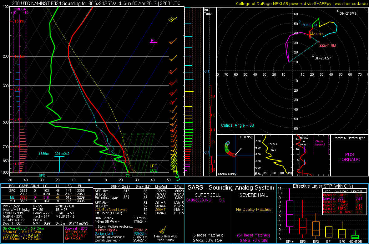
While curved hodographs support some isolated tornadoes as storms initially develop, model soundings show VBV (veer-back-veer) wind profiles that suggest wind profiles won’t be quite supportive of widespread and/or significant/prolific tornadoes. Also, prior MCS activity and storm development in the morning leads to uncertainties concerning instability and wind profile juxtaposition, which could mitigate the development of discrete supercells and strong tornadoes.
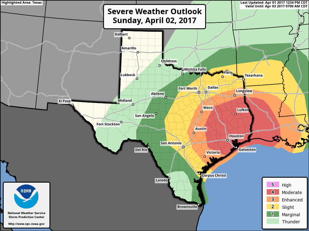
Still, the threat for isolated tornadoes and strong winds appears much higher than normal — and the wind damage threat looks to be quite significant. Accordingly, the Storm Prediction Center has issued a Moderate Risk for severe weather in these regions on Sunday.

3km NAM showing lines of thunderstorms developing by Sunday afternoon over much of Eastern TX, and Louisiana
As this storm moves east, the potential for strong and severe thunderstorms will gradually shift into the Southeast and perhaps lower Mid-Atlantic states early next week. This will also bring more heavy rainfall further north into the Northern Mid-Atlantic and Northeast parts of the country.
We will continue to monitor this threat with more updates through the weekend. The active pattern is expected to continue with more severe weather threats in the Central US as we move into early and mid April.