-2")

Evening Zones Update: Unsettled Weather Returns
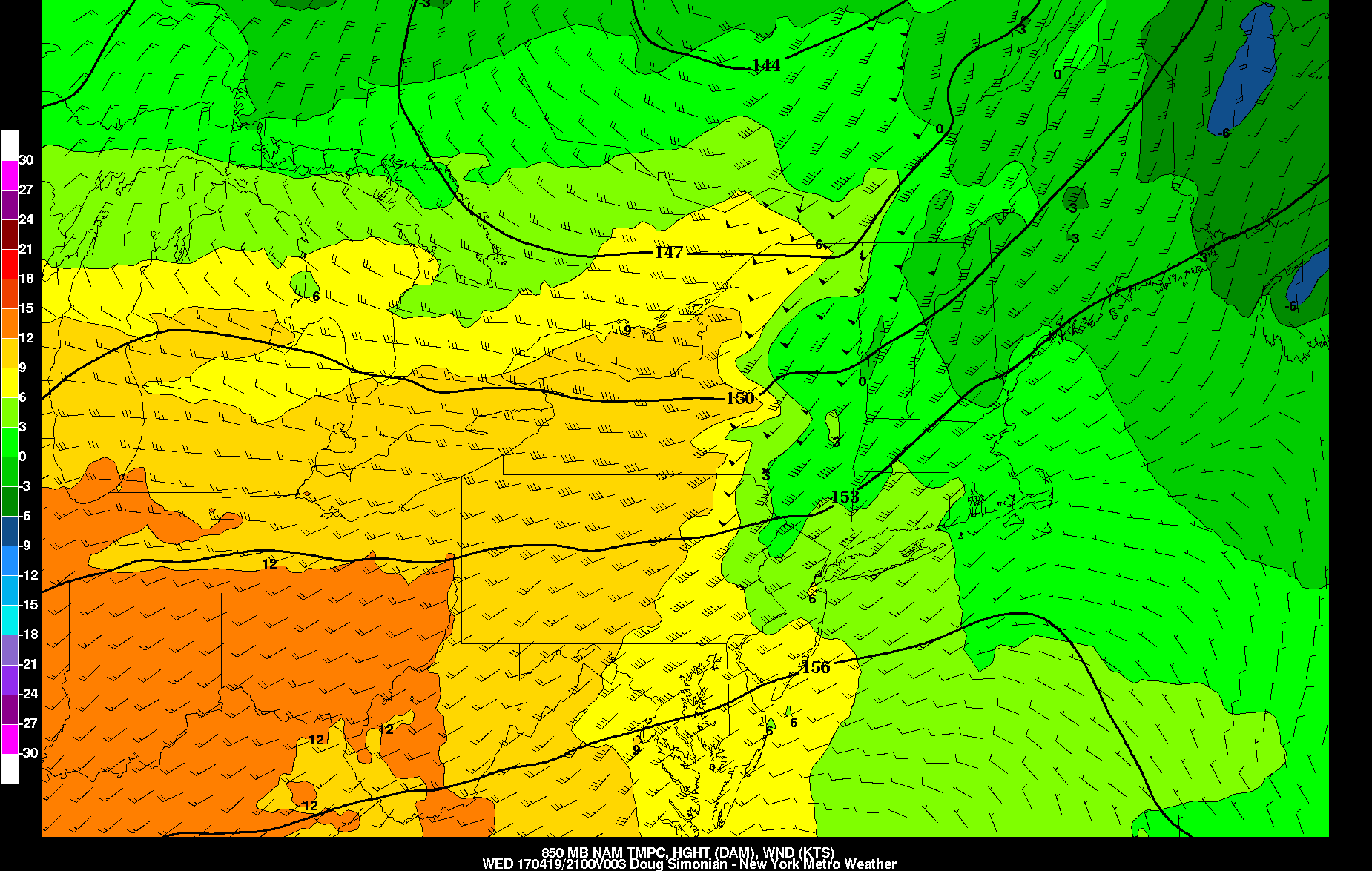
Good evening! Unfortunately, the weather has become much more unsettled, as a cold marine layer has taken over, making things chilly and raw. Temperatures are currently in the upper 40s to low 50s, and will continue to slowly drop over the next several hours. A pretty wide area of light rain has developed in northern suburbs of NYC and is sliding east-south-east. There is a strong 850mb temperature gradient to our northwest which is somewhat acting as a frontal boundary. Also notice in that image how the wind barbs are pretty strong and are blowing almost perpendicular to the isotherms on the warm side of the gradient but still within the gradient. This means that efficient warm air advection is occurring. Warm air advection in a “frontal” boundary can already be a source of lift, but sometimes this lift can get enhanced on top of a marine layer, which we have. This is because the marine airmass is much cooler than the airmass aloft, so it is more dense. This allows the warm and moist air aloft to slide on top of the cold dense air at the surface, which further acts as lift — this is called isentropic lift. Put it together and what have you got? Rain!
This rain should last for the next few hours and will generally remain heaviest north of NYC, where the strongest gradient is located. But its trajectory will mean that NYC’s latitude will also get some periods of rain this evening, and the Yankee and Met games could get interrupted at times by rain. It should not be too heavy, however, but it could come down moderately.
This gradient should weaken somewhat later in the evening, so there will be a lull in the rain for a few hours. But then some vorticity with weak shortwave energy will strengthen as it moves into New Jersey tomorrow morning. This combined with still some isentropic lift as well as precipitable water values around 1.2″ should allow for an uptick in the intensity of the rain tomorrow morning.

Today’s NAM model valid for Thursday morning shows some moderate rain over the local region because of vorticity passing by.
While not everyone will see this uptick in rainfall, it’s possible that some areas may receive up to 0.25″ of rain on Thursday morning, particularly from 8:00am through 11:00am, or so. Once this vorticity in NJ moves away in the afternoon, the activity will cease, as we will have some ridging moving in ahead of a shortwave trough in the Great Lakes.
This ridging may even allow for some sunshine to break out during the afternoon hours, and temperatures should thus rise in the 60s and with enough sunshine, upper 60s to low 70s are possible. A warm front will also be approaching the area, which may try to mix out some of the marine layer, which also explains some of the potentially warmer temperatures on Thursday afternoon.
As we head into Thursday night into Friday, the strong shortwave trough will be approaching the area. This will provide a good amount of dynamics for lift in the atmosphere, though because of the storm passing well to our northwest, the best lift will be focused to our northwest, which should also keep the widespread heavy rain to our northwest.

Today’s NAM model valid for Friday morning shows a strong shortwave trough passing to our northwest, which may trigger some showers and thunderstorms.
Still, though, this storm moving in a northeast trajectory but tracking well to our north will allow the warm front to make good progress northward, which should place us in a nice warm and moist sector. Moisture transport looks very good with this system as it was strong enough to tap into some Gulf moisture. Additionally, the remaining onshore flow will converge with the stronger southwesterlies behind the warm front and ahead of an oncoming cold front on Friday morning, and the atmosphere aloft looks pretty unstable. Thus, while we will avoid widespread heavy rain, we will have to watch for some scattered showers and thunderstorms on Friday morning, some of which could have heavy rain.
After a calmer day with some sunshine on Saturday, clouds will increase again later in the day as a large storm system gathers in the Tennessee Valley. There will be a large moisture plume with this system and there is a large trough and area of vorticity, which will lead to a strengthening area of low pressure well to our southwest, but with an expansive area of rain up and down the Eastern Seaboard.

Today’s GFS model valid for Sunday afternoon shows a lot of rain in the Mid-Atlantic, but a pattern a bit too progressive to force it up the entire East Coast.
This large moisture plume with a deep SW to NE flow aloft will send a large area of rain towards the area on Sunday, and we do expect some rain on Sunday as a result. However, notice how in the above image, a lot of the energy in the trough is being somewhat sheared out and left behind, and the ridging downstream of the trough is not that impressive. This is because today’s model runs have trended a bit flatter with the West-Atlantic Ridge and have also trended more broadly with the orientation of the Polar Vortex in SE Canada (you can see its reflection on the very north side of bottom two panels), which further acts to compress the flow downstream of our storm and turns the wind barbs more due west to east. This prevents true amplification and thus a lot of the rain misses the area.
However, the ECMWF model is a bit further north with the system initially, so it shows a decent amount of steady rain on Sunday. But it also shows a bit of a progressive trend afterward, so the main storm is unable to climb the coast for Sunday night into Monday. So as of now, we are expecting some rain on Sunday, but uncertainty is still very high regarding whether we will see a higher-impact heavy rain event.
We will have a more extensive premium update tomorrow with plenty of details on the evolution of Friday morning’s and Sunday’s potential rain.
Trackbacks & Pingbacks
3aggravated
Comments are closed.