-2")

Late AM Zones Update: Isolated Showers This Afternoon, Potential Cut-off Low Early Next Week
Happy Friday! Some unsettled weather continues today. Showers have been around the region overnight and early this morning, as a warm front tries to lift further into NYC and Northern NJ. However, this warm front will remain further south, as more moist marine influence remains over the region. This will cause mostly cloudy skies, cool and damp conditions to remain this afternoon, for much of the region. Some areas of patchy fog and drizzle is also possible.
Temperatures, particularly from North-Central NJ northward, will struggle rise out of the 50s or the lower 60s this afternoon. Further south, temperatures may get into further into 60s or 70s, if there is enough clearing near or south of the warm front this afternoon. Some more showers are possible this afternoon and evening, as a cold front approaches from the west. But these showers will likely be more isolated or widely scattered across much of the region, with weak lift and very little or no instability, ahead of this front.
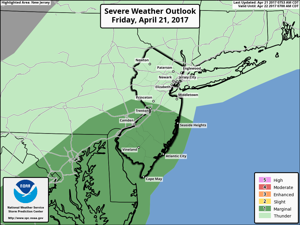
However, over Southeast PA and Southern NJ, a weak triple point developing along warm front, and more instability juxtaposed with some shear, will lead to better chance of few isolated thunderstorms that could be strong to severe later this afternoon or early this evening. Main threats will be for some gusty winds and hail. For this reason, the Storm Prediction Center has a marginal risk for severe weather for these areas later today.

Latest 3km NAM model forecast high temperatures for this afternoon
The cold front will move through later tonight. But some residual moisture will become trapped underneath more nocturnal inversion overnight. This could cause some low clouds and areas of patchy fog to remain late tonight and early tomorrow morning, especially closer to coast. Cloud cover will keep temperatures from dropping out of upper 40s to lower 50s overnight over much of the region. Some interior valleys could be a little cooler in the lower to middle 40s, with little more clearing possible towards daybreak.
The cold front will push further south into Virginia and Maryland tomorrow. This will allow for weak high pressure build in with stronger northwest flow over the region, causing to clear more sunshine the during late morning and afternoon hours. A cooler airmass will be filtering into the region from northwest. But downsloping winds should temperatures rising into low to middle 60s closer to coast. While interior areas may only rise into the upper 50s.
Then more unsettled weather may return later this weekend and early next week a large closed and cut-off low develops Southeast US. This will cause more clouds and some rain to begin moving into Mid-Atlantic region Saturday night and Sunday. But high pressure, will likely keep this rainfall mostly south of NYC until Sunday night or Monday.

GFS model showing the cut-off over the Southeast US early next week, with rain further north up into Mid-Atlantic region.
A stronger ridge building over the Western Atlantic will force the cut-off low to slowly move northward early next week. The cut-off low is still expected remain far enough south and east of the region, that no major impacts are likely in the region. But some more unsettled weather with more showers possible into the middle of next week as the cut-off low beings to occlude and weaken offshore. Temperatures through Sunday through Wednesday may run near or below normal, with some clouds and rainfall.
Later the week, weather conditions will improve. A larger trough out West will support a stronger ridge build over the Eastern US next week. This will lead to a warming trend, with more above normal temperatures possible late in the week and next weekend. For more technical analysis on the weather for next several days, including the potential cut-off low, you can check out the video discussion we posted overnight. Otherwise, stay tuned for more zone forecast updates with more details on the weather through this weekend and early next week.