-2")

PM All Zones Update: Analysis of the Heavy Rain on Tuesday
Good afternoon, everyone! Clouds have increased all across the region as a cut-off low to our south gradually gets closer to the region. Winds aloft out ahead of the storm are almost due south to north, which has sent moisture and clouds in our direction. However, the low-levels still have a large dry wedge, so not much in the way of rain is expected over the next few hours.
Coverage of rain has increased off the SE NJ coast over the past few hours, and it will continue to do so. Flow aloft is still pretty slow with the cut-off low, so it will remain offshore for a while longer. But during the overnight, this batch of rain will eventually move into the area, bringing us “round 1” of rain with this event.
Currently, we have a relatively chilly airmass overhead with plenty of onshore flow and high pressure to our northeast. However, the cut-off low in North Carolina has been strong enough and persistent enough to gather a large Caribbean moisture fetch as well as a more tropical airmass from that source region. This will allow the tropical airmass to surge northward towards our area as the wind flow east of the cut-off low is almost due south to north, which means this tropical airmass will collide with our cooler airmass. This leads to frontogenesis and thus lift for heavy rain. It will almost act as a PRE (predecessor rain event ahead of a tropical cyclone).

Today’s NAM model valid for 2:00am Tuesday morning shows 850mb frontogenesis moving into the area, triggering some showers with embedded heavy rain.
The frontogenesis will move into the area in multiple waves. This is the first round when the more southerly 850mb winds from the warmer airmass collide with 850mb winds that are more due easterly, from the cooler airmass. This collision strengthens the temperature gradient which leads to more lift for precipitation. The main storm is still well to the south at this point, and once the more southerly 850mb winds take over (and the easterly 850mb winds to our north are also replaced with the southerly 850mb winds), the gradient will stop strengthening temporarily and rain will mostly stop, so this round 1 should be brief. The main 850mb jet is also still to the south at this point as well. Thus, there will not be enough dynamics with round 1 for truly heavy rain, but a 1-2 hour burst of moderate to borderline heavy rain is possible anywhere in the general 11:00pm through 6:00am period.
After a lull in the action for a few hours, moderate to heavy rain will return in the afternoon, and this time it should last for a longer period of time.

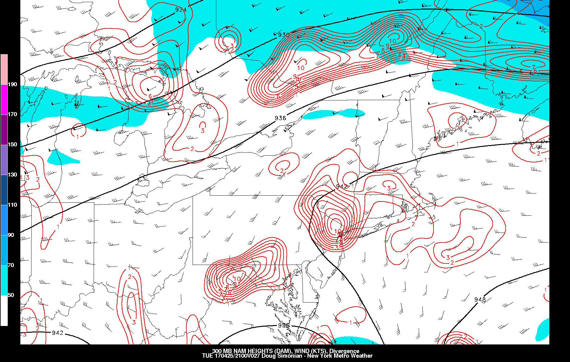
Today’s NAM model valid for Tuesday afternoon shows a strengthening 850mb jet, helping lead to heavy rain.
The cutoff low is currently somewhat warm core, which means that warm temperatures surround its immediate center. This is important because it will lead to a 2nd stronger round of frontogenesis with the rain on Tuesday afternoon. We can see the strengthening cutoff low in the bottom left moving towards the region with mid and upper-level winds all from SE to NW, backing in from the Atlantic into our region with a very efficient moisture fetch. But what’s most impressive is the incredible surge of 850mb winds into the area on the top right. The 850mb jet in itself already leads to lift, but also notice the 2nd surge of warming 850mb temperatures that come with it off the Atlantic. This tightens the 850mb temperature gradient again and considering how fast the 850mb winds are, it leads to very efficient warm air advection of these warm-core high 850mb temperatures.
This is already a classic indicator of heavy rain, but there’s also a somewhat dual jet streak region with the confluent jet to the north and the slightly enhanced 300mb winds on the east side of the cut-off low. All of this together leads to a lot of upper-level divergence, a byproduct of upward vertical motion for heavy rain.

Today’s NAM model valid for Tuesday afternoon shows very strong 850mb frontogenesis and omega.
The 850mb frontogensis and omega are both very strong at the same time, which means that the 850mb frontogenesis is helping to lead to the omega that triggers the lift for rain. Notice also how the strongest frontogenesis and omega is located where the strongest 850mb winds are. These are impressive signals for heavy rain — which should fall from the very late-morning into at least the late-afternoon and early-evening. The cutoff low also moves slowly enough so that this strong synoptic forcing for heavy rain as well as the moisture should be juxtaposed over our general area for a pretty long period of time.
After the strongest 850mb jet moves away from the area, there may be a temporary lull in the action. However, heavy rain should quickly move back into the area as the jet beneath the 850mb level then becomes its strongest and acts as a true firehose from the Atlantic.

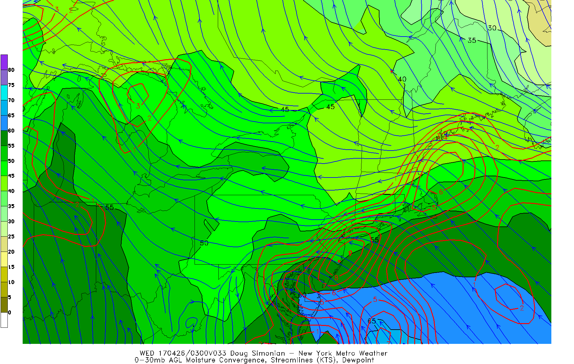
Today’s NAM model valid for 8:00pm on Tuesday shows a very strong 925mb jet from the Atlantic and moving into the area, leading to another round of heavy rain.
Notice the component and the length of the strongest 925mb winds — an indicator of a truly potent low-level moisture source and lift. This 925mb jet will move north during the evening, sending another batch of very heavy rain into the area. Also notice how the strongest 925mb winds quickly slow down as they head inland, which leads to convergence, sending even more lift into the atmosphere. Considering the long ocean moisture fetch of this jet and its tropical origins, it also leads to a lot of moisture convergence, which further increases the chances of heavy rain with this batch.
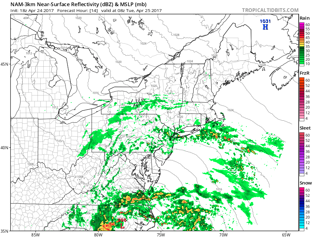
Check out the latest 3km NAM simulated radar animation. It shows the brief round 1 pseudo PRE batch of rain, then a lull, then rain gradually becoming heavier and more widespread during the afternoon, before another brief lull, and then the firehose from the strongest LLJ providing another bust of very heavy rain in the evening through the early-overnight.

Today’s 3km NAM model shows multiple batches of rain tomorrow, heavy at times. (Tropical Tidbits).
All-in-all, this adds up to a solidly heavy rainfall event where may locations will probably end up between 1.5″ and 2.25″ of rain. There will be some locally higher and lower amounts. Heavy rain will cause hazards tomorrow with ponding on the roads, and flash flooding is also possible, though it will not be widespread since there is no true convective forcing. But localized areas in the heaviest downpours both in the afternoon and evening will probably have some flash flooding.
An additional hazard with this storm is coastal flooding with a strong onshore fetch from the LLJ.

Today’s NAM model valid for Tuesday afternoon shows a strong LLJ, which leads to heavy rain but also can bring coastal flooding.
The strong LLJ brings a lot of moisture from the Atlantic for rain, but its long fetch can also lead to coastal flooding, particularly for the NJ shore. Fortunately, there will be a strong enough inversion in the atmosphere to prevent the strongest winds from truly mixing down, which should prevent the most efficient coastal flooding from occurring. But some minor to borderline moderate coastal flooding is still possible. Winds along the coast may be sustained between 20-30mph and gust up to 40mph at times, but these winds should quickly drop off to around or just above half that once you get several miles or more inland due to more friction from the land. Winds will also quickly decrease later in the evening and overnight.
The rain should generally taper off by Wednesday morning as the cut-off low occludes and weakens, though some light onshore flow may still trigger a few isolated patches of light rain.