-2")

5/1 AM Zones Update: Strong T-Storms Possible Tonight, Heavy Rain Likely Friday
Good morning and Happy Monday! A strong cold front will come through tonight with some showers and thunderstorms. There is potential for some severe weather and heavy rainfall over parts of the region. Some cooler and drier weather returns for middle of the week. But another large storm system will likely bring more heavy rainfall by Friday. A more detailed breakdown for this week and look into next weekend’s weather is below!
Today and Tonight:
Low clouds, and areas of patchy fog and drizzle will continue over the region this morning, as maritime still remains over the region. However, more sunshine is expected later this afternoon, as warm front begins lifting northward across the region. This should cause temperatures to rise into the low to mid 70s over NYC metro and Northeast NJ. Further northeast, clouds will be slower to clear with more southeast winds. Temperatures may struggle to get out 60s. Further southwest, temperatures will be rising in the upper 70s to lower 80s with more clearing this afternoon.
Then a strong cold front will be approaching the region this evening. Enough instability could lead to some isolated showers and thunderstorms, especially northwest of NYC later this afternoon and early this evening. But more scattered showers and thunderstorms are likely to be over the region with strengthening low-level jet along and just ahead of the cold front tonight. Some spots could receive between up to 1.00″ of rainfall. While other locations may see far less than that. But this heavy rainfall could lead to some ponding on area roadways and some flooding in poor drainage areas.

The latest HRRR models showing squall line of thunderstorms developing over Central PA this afternoon
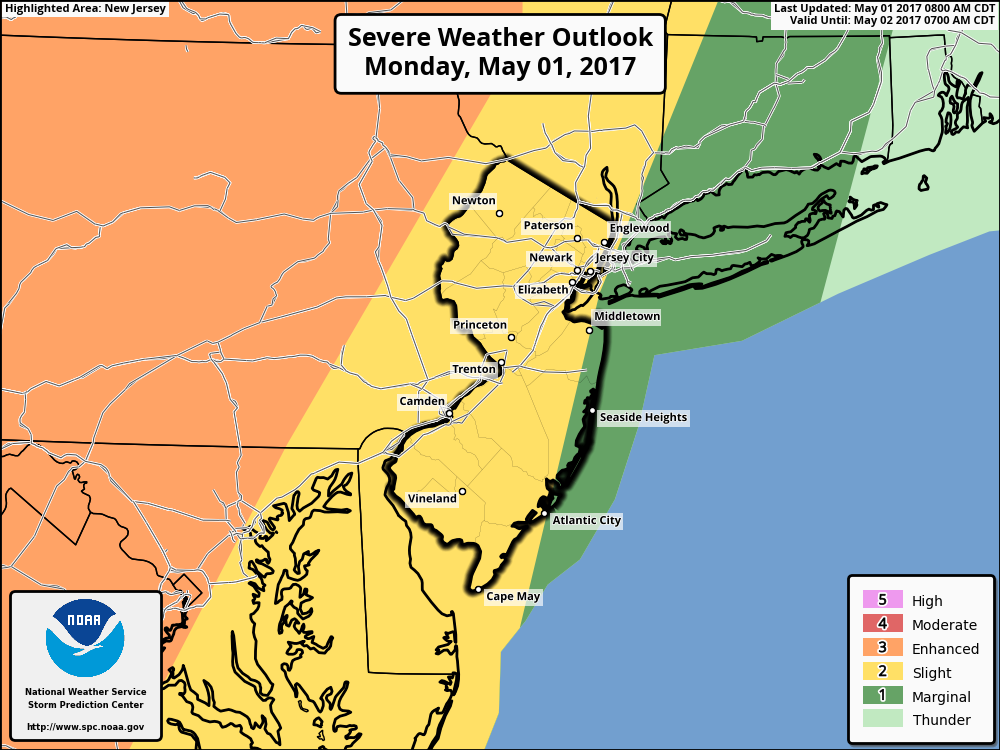
The latest outlook from the Storm Prediction Center now has a slight risk for some severe thunderstorms mainly from NYC and Hudson River west. There is potential for a forced squall line with some gusty winds and frequent lightning to form later today and moves into the western parts of region this evening. Some higher instability and shear may support more isolated damaging winds, especially over Western NJ, Lower Hudson Valley and Southeast PA. But a with a loss of daytime heating and more stable marine influence, this line will likely weaken significantly as it heads further east into coastal areas.
Tuesday through Thursday:
More tranquil weather is expected overall for the midweek period. Weak high pressure should provide some sunshine and clear skies each day between Tuesday and Thursday. Temperatures may still be closer to normal on Tuesday with highs in upper 60s to lower 70s.
Then another cold front the northwest will pass through dry Tuesday night but with a reinforcing shot of cool air for Wednesday. High temperatures will be more lower to middle 60s Wednesday and Thursday. Overnight lows Wednesday night will be in mid-upper 40s over interior valleys and lower to mid 50s closer to the coast.
Thursday night, Friday and the Weekend
A large, deep closed low will be developing near or just west of Appalachian mountains, late this week. Some showers and periods of rain are likely, beginning Thursday night, as lift and moisture increases through the region. Then a firehose strong south-southeasterly low-level jet with plume of sub-tropical and Atlantic moisture will likely cause more rain to become heavy at times, on Friday. There is some uncertainty how this system will finally come together over Eastern US. But given aforementioned dynamics and moisture, and steady progression of this system, there is likely potential for rainfall totals between 1” to 2″ and locally higher, across the region.

ECMWF model showing strong southerly 850mb south-southeasterly jet associated with the storm system Friday
There are indications with more south-southeast flow aloft, that there will be be more elevated instability than last week’s cut-off low. This could result in some isolated thunderstorms with torrential downpours causing more localized flash flooding. Severe weather doesn’t appear likely at this time with more marine influence from southeast winds. However, with tight gradient and the strong low-level jet, some wind gust at least up to 40mph are possible, especially near the coast.
Low pressure will be into Quebec by Saturday. A cooler, a Canadian airmass will come in behind it for the for this upcoming weekend. Temperatures will may several degrees below normal, especially by Sunday. An upper-level low linger over the Northeast may enhance enough instability for some isolated or widely-scattered showers. But mostly dry conditions with a mix of clouds and sunshine is anticipated, at this time.
Stay tuned for more zone forecast updates later this afternoon on threat for strong or severe t-storm tonight and potential rainstorm for Friday.