-2")

5/4 Midday Zones Update: Heavy Rain Friday, Unsettled Pattern Going Forward
Good afternoon! Today is the proverbial calm before the storm with plenty of sunshine so far today. Sunshine will begin filtering behind increasing high clouds later this afternoon, as high pressure also starts moving off the New England Coast. This will cause light winds to turn more southeasterly of the ocean and keep temperatures this afternoon, in the mid-upper 50s closer the coast. While temperatures will still rise into the lower to middle 60s further inland, with less marine influence.
Mostly cloudy skies are expected tonight. A large closed low and storm system we’ve been discussing the week, will begin impacting region by late tonight. Some isentropic lift with mid-level warm advection may cause some showers to begin breaking out from southwest to northeast. But steadier rain, will probably hold until closer to daybreak for most of the area.
Then tomorrow morning, more steady rain will become heavy at times later in morning and into the mid-afternoon hours, as south-southeasterly low-level jet moves northward through region. This will be firehose of subtropical moisture with bands of heavier rain coming off the Atlantic. But it will somewhat progressive over the region. So rainfall totals are expected to range between 1” to 2” are expected over much of the region.

NAM model with 850mb low-level jet moving through region later tomorrow morning
However, latest mesoscale model guidance indicates some weak instability and strong moisture convergence over the region may support some embedded, elevated convection with very heavy rainfall and lighting possible. Winds more aligned south-southeast in lower-levels could also some localized flash flooding on roadways or poor drainage areas, with rainfall totals up to around 3” or 4” over the region.
That being said, we don’t anticipate more significant flooding, particular from rivers and streams, around the region. Most rivers are well below flood stage, due recent drier conditions and would likely be able to handle this amount of heavy rainfall expected.

Saddle River at Lodi, NJ forecast to rise but remain well below flood stage after Friday.
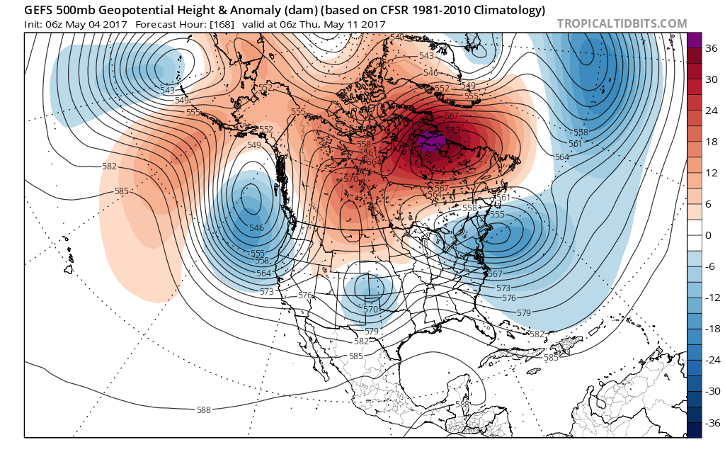
So after this rainfall tapers off to showers Friday night, we expected improving conditions, with little more sunshine at times, over the weekend. However, high-latitude on the Atlantic side and an omega block over the CONUS will likely cause the closed low to cut-off and meandering over parts of Southeast Canada and the Northeast with more unsettled weather into the next week.
For Saturday, a warm front will lift northward through region. This could allow temperatures to rise into middle 60s with some clearing skies and southerly winds. Then another round of showers will likely arrive later Saturday afternoon and evening, as a cold front and shortwave approaches. More lifting may lead to some briefly moderate or heavy rain with these showers. But a lack of deeper moisture, will not support enough heavy rainfall for more flooding.

Closed 500mb low centered over the Eastern Great Lakes still keep unsettled weather with some scattered showers later Saturday afternoon and evening
For Sunday and Monday, the region will more the backside of the cut-off, upper-level low with more west-northwest flow. This will support a even cooler, drier airmass with mostly below normal temperatures over the region. But the atmosphere will also become unstable with colder air aloft and daytime surface heating. Some isolated or scattered showers are still possible during each afternoon and early evening.
By Tuesday and Wednesday the cut-off low may meander far enough north, for more pleasant, warmer and drier conditions. But overall the pattern will likely remain more active or unsettled, with substantial blocking remaining in the middle and high latitudes. This will keep any major warmth out the region for another more potential for more frontal systems or cut-off lows to impact the region with significant rainfall over next couple weeks. Stay tuned for another zone forecast and premium updates on the pattern going forward!