-2")
Unsettled Thursday, eyes on weekend coastal storm
Good morning! A beautifully pleasant and calm weather day on Wednesday is behind us, and the weather will take a more transitional and unsettled turn in the Northeast states today. You can thank the weakening grip of a large mid level ridge for that, as its departure will open the door for multiple disturbances to move into the region. High pressure has already begun its shift off the Eastern US coast this morning.
A disturbance in the atmosphere’s mid and upper levels will begin to approach the area this afternoon and evening. The first thought going through many peoples minds will be the potential for strong and severe thunderstorms – but there are several mitigating factors that will be acting against those chances today. Instead, the potential for showers and a few isolated thunderstorms is expected to evolve.
It is worth noting the important factors that contribute to severe weather potential as we look at the forecast today: Instability, lift, and sufficient wind shear. During the late morning and early afternoon today, instability in the atmosphere will increase steadily as a result of increasing moisture and daytime heating. The degree of wind shear and the amount of lift in the atmosphere, however, are expected to be meager.
This suggests that the potential for strong and severe thunderstorms will be essentially be capped at a lower ceiling than most events. Think of it this way: Despite the presence of instability, the lift to help storms develop is sporadic at best. And even if storms do develop, the wind shear in the atmosphere’s mid levels is weak enough that storms will have trouble organizing. Instead, we expect the potential for showers and storms, some of which could be sporadically strong during the afternoon.

A few showers and thunderstorms are likely Thursday afternoon, but severe weather is expected to be isolated.
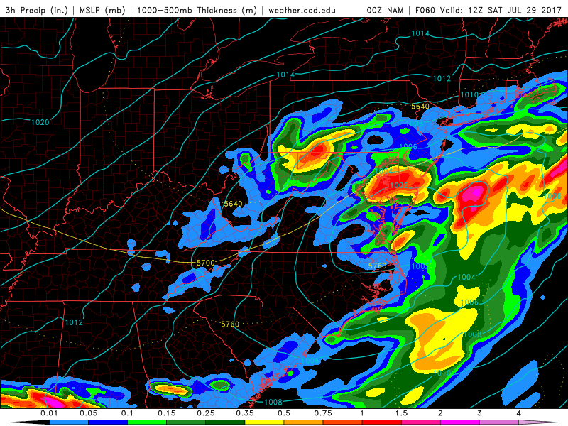
Gradually, by Thursday evening, the threat for thunderstorms will end as the front sinks southwards towards the Mid Atlantic States. A relatively quiet Friday morning is then anticipated, but all eyes will turn to a developing coastal storm in the Mid Atlantic states. A large shortwave trough will be moving towards the coastal plain and providing an impetus for the development of a surface low.
Forecast models, however, differ greatly in their evolution of the storm system up the East Coast. While rain, steady and heavy at times, is almost a sure bet in the Mid Atlantic states from Friday afternoon into Friday evening, uncertainty greatly increases Friday evening into Saturday morning as the storm moves up the coastal plains. A further north and west track of the surface low could mean widespread rainfall throughout the Northeast States this weekend, while a further south and east track would lead to periods of rain and then clearing for Saturday and Sunday.

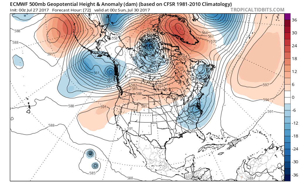
In the mid levels of the atmosphere, a considerable amount of spread still exists on forecast models regarding the exact storm evolution this weekend. However model and ensemble guidance overnight suggests a cut-off low will over Mid-Atlantic region.
It is important to consider that the weather pattern across the United States remains relatively progressive. The incoming shortwave trough, which helps develop the low pressure, is positively tilted on Friday. This means that the majority of its energy is located in the bottom left quadrant of the trough, which often allows the system to be progressive in nature. The west to east oriented pattern across the United States is not being slowed down by any traditional “blocking” high pressures to our north on Friday. But latest guidance suggests a ridge over the West coast may may roll over into Southeast Canada and connect with another blocking ridge over Greenland, forcing the cut-off low somewhere over the Mid-Atlantic region.
However, this doesn’t mean the Northeast states will be void of any impacts — more showers are likely on Friday afternoon and evening in the Mid Atlantic, with showery activity spreading north of there into parts of Pennsylvania and New Jersey. Then more bands of rainfall are likely develop and spread northward Friday night into Saturday morning (again, with the northward extent being modulated by the systems track and subsidence further north). A pressure gradient between high pressure to north, will also cause some gusty east-northeast winds, especially along New Jersey and Delmarva coast. This could result in some minor coastal flooding or beach erosion during high tides on Saturday. Then as the low cut-offs to the south, weather conditions will gradually improve. But somewhat unsettled weather may continue with some showers still possible into Saturday night and Sunday.
Stay tuned for further updates today and tonight as we continue to analyze the latest information and data for the approaching storm system!
Trackbacks & Pingbacks
2hotmail
Comments are closed.