-2")

Premium PM Update: Very Warm, More Humid Midweek…More Unsettled Late Week
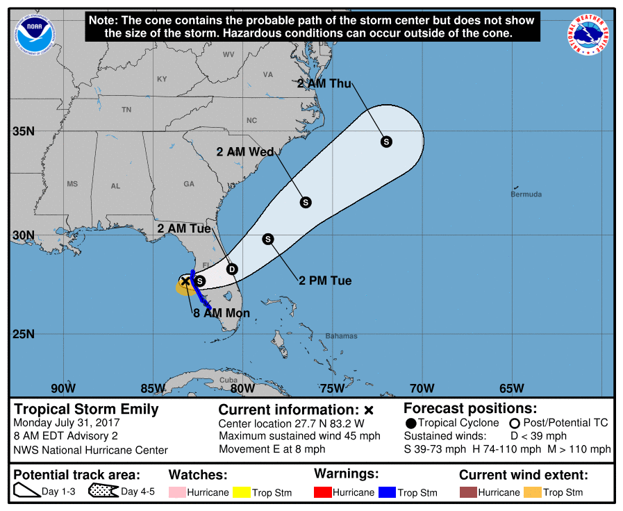
After some cooler than normal and dreary weather much of last week, more summer-like weather returns this week. This afternoon we already saw temperatures in the mid-upper 80s. The next few days will feature warmer than average temperatures. However, more unsettled weather may be arriving by the end of this week, as a large trough and frontal boundary approaches from the west. Meanwhile, Tropical Storm Emily over Florida today, will be moving out to sea later this week.
First for tonight, mostly tranquil and comfortable conditions are expected. A few isolated showers or thunderstorms that developed over Interior NY and PA, will diminish this evening, as a surface trough and instability weakens. Then skies will be clear to partly cloudy for the rest of tonight, with low temperatures ranging from the 60s over the Interior to lower 70s near the coast. If skies clear enough, some of the interior valleys and Pine Barrens may drop into the mid-upper 50s by daybreak, with more radiational cooling. Some areas of patchy fog may also develop over Interior valleys overnight.
Some very warm or hot weather is likely on Tuesday and Wednesday, as mid-level heights continue to rise and more sunshine dominates. Humidity will be a little higher, but not quite at oppressive levels. So no significant heat-related hazards are anticipated. High temperatures will once again be in the mid-upper 80s during the afternoon hours over much of the region. Some of the typical hot spots like Newark, NJ could reach 90 degrees or higher. But some afternoon sea-breezes are likely to develop and could keep temperatures from rising out of the lower to middle 80s, closer to the shore again. So any plans to escape to the beach tomorrow are looking great overall.

NAM model forecasting very warm temperatures with some isolated showers or t-storms developing during Wednesday afternoon.
However, a few isolated showers and thunderstorms are possible during the afternoon and evening hours each day, especially over the Interior — as a surface trough develops inland with some instability increasing each day. A mid-level shortwave may also enhance coverage of convection more on Wednesday compared to Tuesday. Weak shear will support more slow-moving thunderstorms that can produce locally heavy rainfall and flash flooding. Models suggest stronger instability, such as MLCAPE to support thunderstorms becoming locally strong to severe, especially on Wednesday afternoon. But these thunderstorms are likely to be pulsing in intensity, without more shear to help keep updrafts organized.
A stronger frontal boundary, associated with more potent shortwave energy along the upper-level trough will begin moving into the Northeast and Mid-Atlantic regions on Thursday. It will be another very warm and humid day with high temperatures in the mid-upper 80s to possibly around 90 again in some spots. But more clouds may be increasing during the afternoon, due to increasing mid-level warm advection. This may keep some spots from reaching 90 degrees. Then more widely scattered showers or thunderstorms are possible Thursday afternoon and evening, as the frontal boundary begins approaching the region. But still the best chances for showers and thunderstorms will be over Interior parts of Northeast, as stronger ridging from the Western Atlantic remains over the coastal plain, keeping the atmosphere more capped for convection.
Then the frontal boundary and upper-level trough axis will be gradually moving closer to the I-95 corridor with more sub-tropical moisture from the Gulf of Mexico and Atlantic streaming northward along and ahead of this front. Precipitable water values will be well above normal and possibly over 2.00″. There is some uncertainty with the timing of this frontal boundary, as the West Atlantic ridge may cause this boundary to slow down. So forecast details will likely be fine-tuned throughout the week. But current model trends indicate stronger wind fields and lowering heights more associated with the upper-level trough, that may support more organized convection with heavy rainfall and localized flooding potentially becoming a more significant hazard threat by Friday and Saturday.

GFS model forecast for Saturday with a frontal boundary associated with a potent shortwave trough and upper-level jet streak moving through the Northeast and Mid-Atlantic regions.
However, a lack of EML (elevated mixed-layer) advection, with mid-upper level southwest flow may not keep the atmosphere initially capped. So with more dynamics, more numerous showers and thunderstorms may develop ahead of the frontal boundary and thus reduce instability for potential for severe weather. Then the upper-level trough axis and frontal boundary will be moving offshore on Sunday. So more sunshine is expected for the rest of the weekend with a drier northwest flow and stronger high pressure over the Northeast and Mid-Atlantic regions. A cooler Canadian airmass will also coming in behind the front. This will likely keep high temperatures on Sunday into early next week in the lower to middle 80s.
Meanwhile, Tropical Storm Emily that formed this morning just off the Florida west coast, will continue northeast and over the Western Atlantic this week. Moisture from the system will not feeding into our into this storm system late week. The only impacts from Emily will possibly be some swells and rough surf over the Mid-Atlantic and Northeast shores later this week. Stay tuned for more ShoreCast updates on this potential for more rip currents later this week.
So enjoy another episode of summery weather, as we begin the month of August this week. It will likely turn more dreary again at some point later this week and then some cooler than average temperatures may return for while, by Sunday and early next week. Stay tuned for more premium updates including articles and videos with more forecast details on the thunderstorm potential this week.