-2")

Premium Long Range: Cooler, Active Pattern Next Week…More Changes Late Month?
Good morning! More summer-like weather with more heat and humidity will continue for the rest of the week,with some scattered showers and thunderstorms possible each afternoon or evening. But it appears the Western Hemispheric pattern will undergo another more significant changes to support some cooler weather again for next week.
First changes, will start occurring over North Pacific as usual this week. An upper-level low will be near the Aleutian Islands or Southwest Alaska. This will cause a high-amplitude ridge to build over the West Coast by early next week. This will result in a larger trough digging and encompassing much of the Central and Eastern US over for next week. Then cooler airmasses from Canada will be invading the CONUS, with temperatures well below over the much of the Northern and Central Plains and into parts of Great Lakes and Ohio Valley.
A cold frontal boundary associated with upper-level trough moves through the Northeast and Mid-Atlantic regions at end of this week. Showers and thunderstorms are possible over Northeast and Mid-Atlantic. Stronger winds fields, lowering heights and moisture streaming northward from Gulf of Mexico, will support some severe weather and heavy rainfall risks sometime Friday into Saturday. Especially over Interior parts of New York and Pennsylvania where current timing on models will favors more kinematics juxtaposed with more surface-based instability, during Friday afternoon and evening. But is if this frontal boundary trends slower, there might be more potential for severe weather and heavy rainfall closer to the I-95 corridor between BOS to DCA on Saturday.

GFS model showing the cold frontal boundary and upper-trough moving through the I-95 corridor during Saturday
Then behind the storm system, a cooler, less humid airmass will be moving into Northeast on Sunday. Temperatures will still be warm during the day, but will several degrees below normal for August, during the beginning of early next week. It will be refreshing change to summer weather we have recently. However, stronger subtropical ridging stretching from the Southeast US into the Western Atlantic, will keep deeper troughiness more over the Central Plains and Great Lakes, next week. The coolest temperature anomalies will likely reside over the Northern and Central Plains. Also without more high-attitude blocking in the Atlantic , the pattern will remain more active and progressive over the Northeast and Mid-Atlantic. So more unsettled weather with chance of more rainfall is expected next week. Temperatures remain closer to average over parts of Southeast US
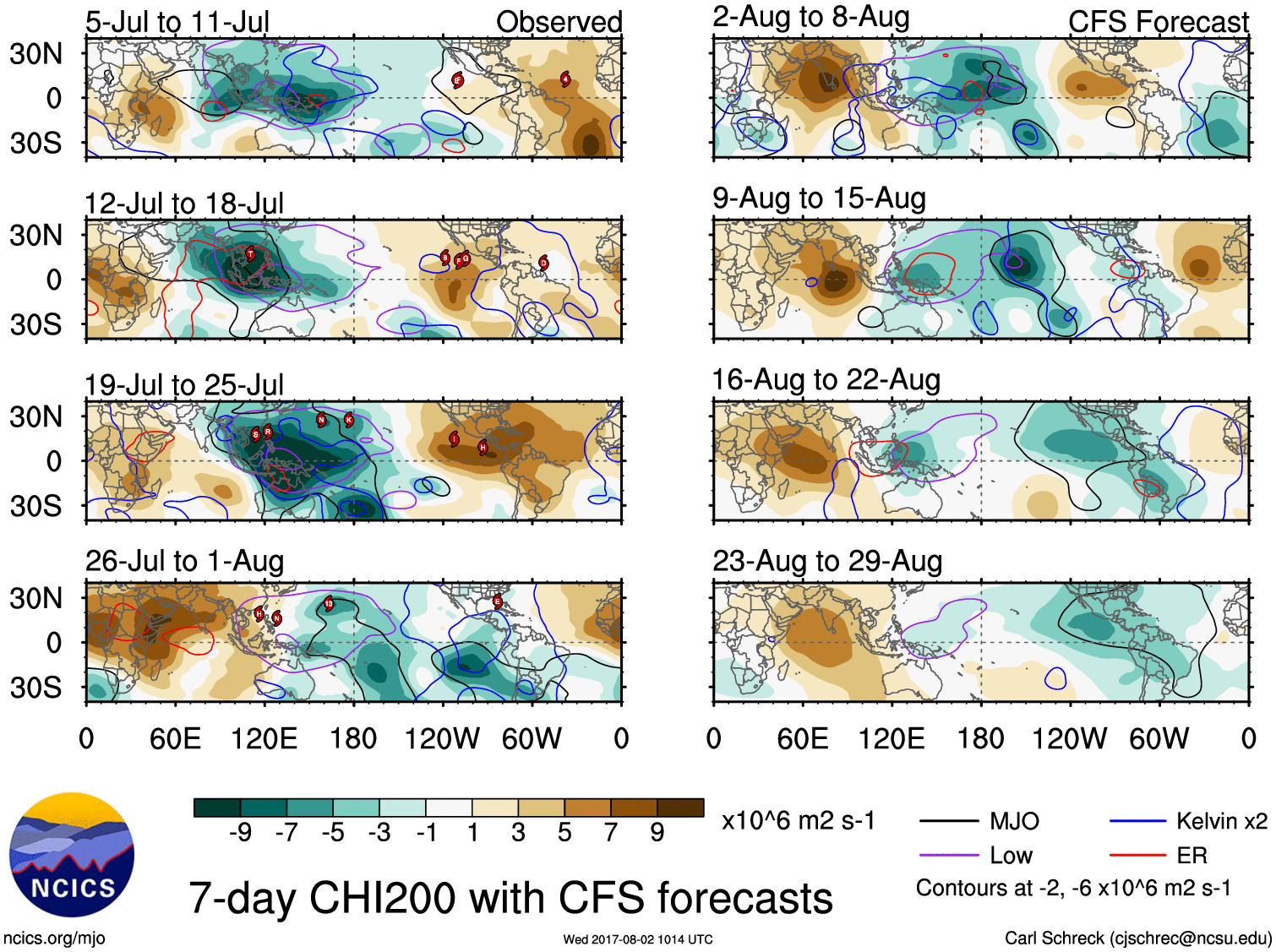
Meanwhile, the ridge will support much warmer temperatures and more over the West Coast next week. Temperatures could well above average for August especially over much the Rockies . The ridge will keeps more storms systems out the Pacific from entering the west. As such, drier conditions are expected including over High Plains where there are severe drought conditions. Currently the MJO tropical forcing is mostly over Western Pacific where Typhoon Noru will threatening Japan by this weekend. However, after Noru weakens and moves out of the Western Pacific, the MJO/tropical forcing will likely shift back towards Western Hemisphere, as a CCKW (Convective-Coupled Kelvin Wave via Micheal Ventrice, PHD) passing over the Atlantic late this week. Behind the these CCKW are typically more favorable atmospheric environment over the tropics behind them. So we will be watching for more tropical activity over the Atlantic basin, next week. Although the models are currently not bullish on significant tropical storm development. Latest ECMWF ensembles suggest 40-60% probability for tropical storm over Central Tropical Atlantic early week.

200mb velocity anomalies indicates more tropical for over Western Hemisphere and Africa over the next two weeks,
Then more changes to the North Pacific pattern may occur again later this month. After next week, the AAM is forecast to be going negative by the GFS ensembles. If this is correct, MJO/tropical forcing shift back into Indian Ocean or phase 3 during third week of August. This will cause a ridge over to build over Central Pacific and troughiness over the West Coast of North America. In turn, stronger ridging will to return over the Central US with temperatures trending well above normal for the third and fourth week of August. A gradient or “ring of fire” pattern on top this may support more episodes of severe weather returning over the Northern Plains and Midwest again. Further east, more zonal heights on periphery of this ridge, will support temperatures to moderate above normal over Northeast and Mid-Atlantic region.
Finally, as mentioned in our last long-range update, during the last week of August, the latest CFS weeklies still suggest MJO/tropical forcing may propagate back into Western Hemisphere again. So we have more reshuffling of North Pacific pattern towards more ridging over West Coast and troughiness over Central and Eastern parts of United States. As well as renewed tropical activity as we move toward the peak of the Atlantic Hurricane Season.
So if you are already tired of the heat and humidity this week, more comfortable warm weather will return for much next week. But likely more cloud and rainfall at some point. Then some more heat and humidity is possible for third week of August. Then we watch for more changes towards the end of the month. Stay tuned for more premium updates on the long-rang pattern over the next couple weeks!