-2")

Premium: Heavy Rainfall, T-Storms, Localized Flooding Possible by Tonight
Good morning and happy Monday! Mostly cloudy skies are expected today, as a storm system from the southwest begins impacting the parts of Northeast and Mid-Atlantic regions. Temperatures will likely not rise much out of the lower to middle 70s. Showers will spread northward towards the Northeast states later this morning and afternoon — and some could produce some briefly heavy downpours. Chances for steadier, heavier rainfall and some thunderstorms will increase as the dynamics increase later today.
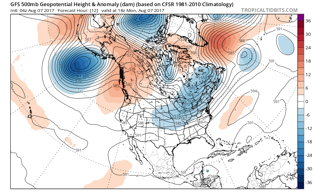
First, a shortwave trough will be digging on the the downside of a ridge over the West Coast and underneath the upper-level low over Southeast Canada early today. As the shortwave trough amplifies over the Ohio Valley, a broad area of low pressure will develop over Virginia and Maryland in response — moving northeastward later today and tonight. Some initial warm-air and theta-e advection into the Northeast States will support bands of rain moving in from the southwest this morning and early afternoon. Underneath the right entrance region of a 110kt+ upper-level jet streak, the low pressure is expected to gradually consolidate and deepen with more rainfall expanding northward from the lower Mid-Atlantic region later today and tonight.
However, the low is not likely to intensity very rapidly due to a number of synoptic features. Although the NAO is negative with some mid-level height rises over Greenland/Davis Strait, these appear to be mostly transient. Without stronger high-latitude blocking on the Atlantic side, the pattern will remain somewhat progressive. Thus this storm system is more likely to exit quickly off the coast by late tonight or Tuesday morning. Also mid-level vorticity remains sheared out and disjointed inside the shortwave trough. This will result in weaker or less focused divergence (rising air in the mid-levels) which will mitigate intensification.

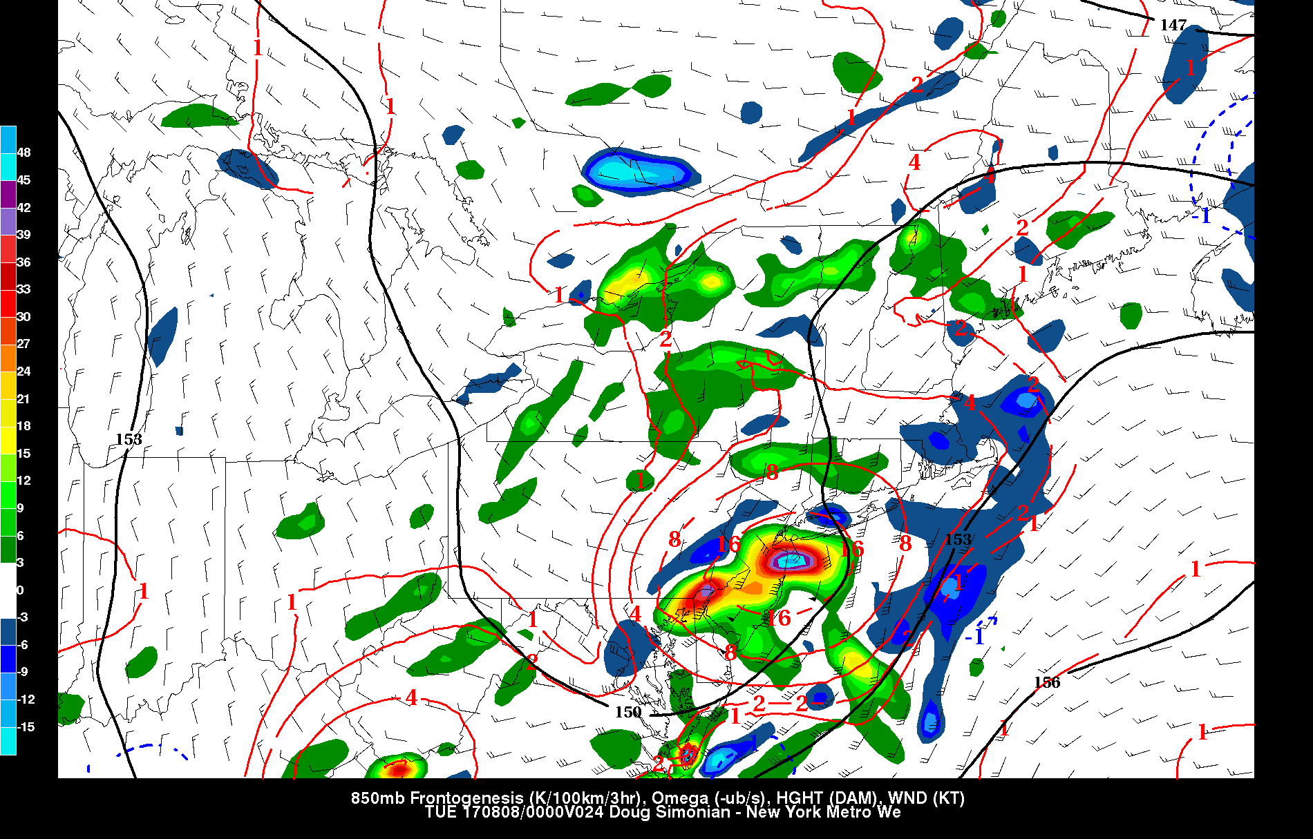
NAM model showing sheared out 500mb voritcity with the shortwave through and in 300mb jet streak running north of the Mid-Atlantic region, as low pressure deepens at the surface.
Differences remain amongst model guidance on the handling of dynamics and rainfall totals over the Northeast. But in general, strong mid-level frontogenesis is indicated along a thermal gradient near or just north of the low track. Strong moisture convergence will be enhanced along the warm front, with a strengthening 40-50kt southwesterly low-level jet. These dynamics coming together will support a band of heavy rainfall just north of the low track, over the Mid Atlantic, Southeast PA and South/Central NJ.
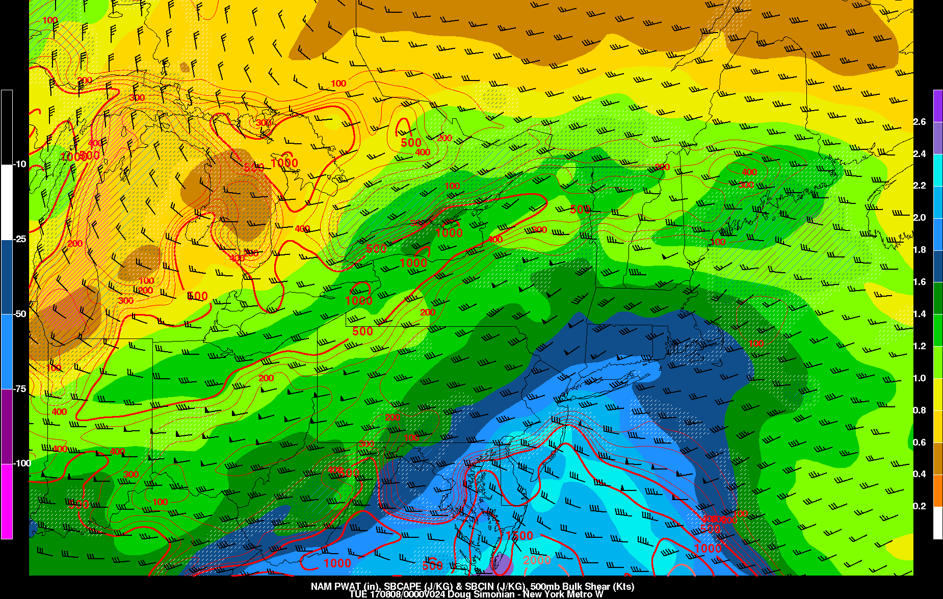
Model guidance indicates, a sub-tropical plume of moisture will moving northward with precipitable water values nearing or going over 2.00″ by this evening. This could support torrential downpours with heavy rainfall totals and localized flash flooding in some spots. Therefore the National Weather Service has issued Flash Flood Watches for parts of the region, including the New York City and Philadelphia metro areas. At this time, we are anticipating parts of these regions to receive between 1″ to 3″ rainfall by tonight. However, due the aforementioned factors, there is still some uncertainty where the placement of best dynamics and moisture will be for heavy rainfall. There also tendency for heaviest rainfall to occur north of the highest precipitable water values, where there is more lift from moisture convergence. Therefore, confidence is lower than usual, on amount of rainfall over parts of the region.

NAM model showing strong moisture convergence near or just south NYC metro
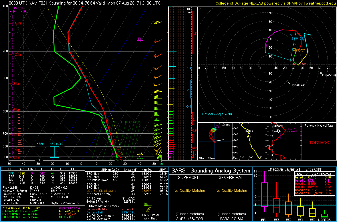
The warm front associated with this low, is expected stay south of the NYC metro area. This will keep much of the region in a more stable, maritime airmass. Further south over the Mid-Atlantic, there is the potential for more severe weather in the warm sector. A 40-50kt 850mb-925mb southwesterly jet streak will support stronger shear/convergence and higher dewpoints to advect over the Lower Mid-Atlantic region. If skies clear for more sunshine, the airmass will destabilize quickly. This will support some strong to severe thunderstorms with the main threat being damaging winds. But model soundings indicate some strong directional shear and low-LCL heights, especially over parts of Eastern VA that could support a few supercells with isolated tornadoes, if instability is realized. For these reasons, the Storm Prediction has a marginal and slight risk for severe weather as far north parts these areas further south.
Later tonight, rainfall should taper off as low pressure and shortwave trough move off the coast. High pressure should build into the Northeast and Mid-Atlantic regions with more pleasant weather on Tuesday, Wednesday and likely on Thursday. High temperatures each day are expected to be in the lower to middle 80s with more clear skies and humidity at comfortable low levels. Overnight lows will range from mid-upper 50s over Interior valleys to lower to middle 60s over more urban areas and coastal areas.
Trackbacks & Pingbacks
2webshots
Comments are closed.