-2")

Severe T-Storms Possible for the Northeast Today, Irma Becomes a Category 5 Hurricane
Good morning! Many eyes are on still Hurricane Irma. Which is now a Category 5 hurricane with 175 mph maximum sustained winds, as of latest reconnaissance reports and the 8am EDT advisory from the National Hurricane Center. It continues to move westward at 14mph and is major threat to the Northern Leeward Islands. Hurricane warnings are in effect for those islands, including for Puerto Rico and the Virgin Islands. Meanwhile, more unsettled weather with showers and thunderstorms, is likely over the next few days, with a strong cold front and upper-level trough moving through the Northeast and Mid-Atlantic regions. But there is potential for some severe weather later today, especially over the Interior locations.
Before more thunderstorms, some high level clouds will likely filter with sunshine for much of today. 850mb temperatures between 15°C to 17°C and south-southwest winds will support temperatures to rise into the mid-upper 80s, this afternoon, especially away from the coast. A few spots may approach or reach 90 degrees, before clouds thicken or increase later this afternoon. These temperatures are actually slightly above normal for early September. Humidity will also be increasing this afternoon, with dewpoints rising into the middle to upper 60s. So it will feel like summer again briefly.
Large scale forcing with a strong upper-level streak and lowering heights accompanying the cold front and trough will likely result in some scattered showers and thunderstorms the morning and early afternoon hours over Western parts New York and Pennsylvania. Models indicate some higher instability juxtaposed with modest shear will be building throughout the day, with more sunshine ahead of this activity. This may lead to more organized lines of strong to severe thunderstorms moving further east over the mountains later this afternoon and early evening. Thus the Storm Prediction Center has issued a slight risk for from Eastern parts PA to Western parts of New England.
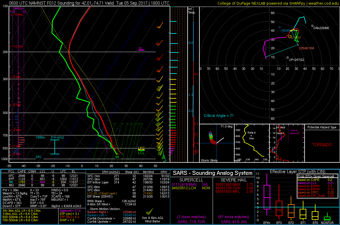
The main severe weather threat will be for damaging wind gusts. NAM model soundings also indicate curved hodograph with winds veering with height and low LCL heights especially over the Catskills. Thus, a few embedded supercells with some large hail or isolated tornadoes are also possible. But this threat will be mitigated by high freezing levels and only modest mid-level lapse rates. These showers and thunderstorms are likely to weaken as they approach the I-95 corridor and coastline later this evening, as instability diminishes with the loss daytime heating and more stable marine influence from southerly winds near the shores. But some isolated strong thunderstorms with heavy rainfall and frequent lightning are still possible.

NAM models showing high MLCAPE (instability) juxtaposed with around 35-45kts of 500mb bulk shear over Northeast PA Hudson Valley into Western New England late this afternoon.
Then a strong ridge over the Western Atlantic will cause this cold front to slow down as it moves just off the coast, late tonight, Wednesday and Thursday. A few weak waves of low pressure running along this front, will enhance more lift and moisture. Additional rounds of showers or periods of rain with more isolated/embedded thunderstorms are still possible, especially near the I-95 corridor and coastal areas. Some heavy rainfall and localized flooding is possible, as precipitable water values will be near 2.00″. But instability will be lower, so severe thunderstorms aren’t anticipated. More cloud cover and rainfall will keep temperatures more below normal with highs only in the lower to middle 70s.
Finally, some improving weather is likely by late in the week. As the cold front will finally push further offshore on Friday, as some ridging over the Western Atlantic begins to break down. Another weak cold front and shortwave trough may produce some isolated-scattered showers on Friday or Saturday. But overall Canadian high pressure building from the Great Lakes will provide more pleasant weather for this upcoming weekend. Stronger ridging over Northern Rockies will continue cause lower heights over much of the Eastern US. Thus temperatures will cooler than normal again with daytime highs struggling to reach the upper 60s or lower 70s on both Saturday and Sunday.

GEFS with below normal temperatures over most of the Eastern US this weekend.
Back to Hurricane Irma, previously model and ensemble guidance were showing a large, deep trough or cut-off low over the Mississippi River Valley and blocking ridge over developing over Western Atlantic. This pattern would of have supported Irma to track further north into the Mid-Atlantic or Northeast. Instead models are now more progressive with the full-latitude trough, over the Eastern United States this week, due to a lack of high-latitude blocking, from our wave-breaking originating from the Pacific.This will allow for more upper-level ridging along with high pressure to build over the Northeast and Mid-Atlantic region, keeping Irma around the Southeast US vicinity at least into early next week.
Irma will likely continue to remain a very powerful hurricane, as it remains underneath anticyclone and moves over very warm sea-surface temperatures, over the next few days. Irma is will be capable of more catastrophic damage from high winds and storm surge. But the storm will likely undergo some eyewall replacement cycles with fluctuations in intensity, which are difficult to predict. There continues to be some uncertainty on how far west Irma will track. Model solutions still vary on the extent of a weakness in the ridge, in left behind the full-latitude trough and how much shortwave energy left behind also interacts with Irma. Any land interaction with Cuba or Hispaniola will also cause the storm to weaken. But Irma currently appears to be taking a track very close to or right over the Florida Peninsula with some major or severe impacts likely this weekend or early next week.

Latest model track forecasts, showing a turn northward into the Bahamas and or very close or near the Florida Peninsula
That being said, everyone with interests over the Southeast US, should continue monitor Irma for at least some significant directs impact. It’s possible as high pressure moves offshore, some remnants from Irma could move northward impact the Northeast and Mid-Atlantic regions with some heavy rainfall later next week. Some higher surf and rip currents are possible from Irma this weekend. But the risk for Irma to make landfall as a hurricane north of the Carolinas, is now very, very low, with the current pattern being shown on model and ensemble guidance. Stay tuned for more premium forecast updates our dashboards and with more articles to come this week. Another premium article will be out by this evening, with another full update on Hurricane Irma.