-2")
Strong storm expected in the Northeast this weekend
Amidst an anomalous pattern, which features a large ridge in the Western United States and a changeable Pacific Ocean wave progression, sensible weather changes have been observed across the Continental United States. Nowhere is this more apparent this morning than Minnesota, where snow is on the ground across much of the Central and Northern parts of the State after a very warm October. Nationally, though, the anomalous warmth has gone on a hiatus as well, as the Western USA ridge acts to promote cooler air surging southward.
These anomalous patterns on either of our coasts can often preclude multiple storm threats, including the potential for larger ones, and this pattern will be no different. After a handful of storm systems in the Central US and Great Lakes will come a larger, more significant storm threat later this weekend in the Northeast States. A deep trough is expected to dig into the Mississippi River Valley this weekend, interacting with energy over the Southeastern United States.
The deep, full latitude trough is expected to interact with tropical moisture, and a strong low pressure system is expected to develop in the Northeast States this weekend. Forecast models are in good agreement that by later Sunday into Sunday Night, a low pressure center will reside somewhere near or over New England. There is still some uncertainty in regards to the exact track and intensity of this storm. But it looks increasing likely there will be a large area of moderate to heavy rainfall potential, owing to impressive mid and upper level atmospheric dynamics.

GFS model showing an amplifying 500mb shortwave trough and a dual 300mb jet streak resulting in low pressure deepening near New England and more heavy rainfall over parts the Northeast, late Sunday into Sunday night
One potential wrench in the setup is exactly how much tropical moisture gets entrenched in the system. Earlier forecast model runs had suggested that the entirety of a tropical system from the Caribbean (still not even officially a tropical depression) would phase in with the storm system, resulting in a powerful and potentially highly impactful storm. But more recent model runs seem more reasonable in suggesting that only part of the tropical moisture will become entrenched, with the majority of the tropical disturbance itself left behind.
Nevertheless, the storm system looks likely to be strong, and the strongest storm system in the Northeast states so far during the cold season. Ensemble data is in good agreement that a heightened chance of 2″ or more of rainfall exists across New England, specifically from the Catskills northward into the Green Mountains and into Maine and New Hampshire. These regions seem likely to be most favorably placed in relation to the mid and upper level jet dynamics and juxtaposition of tropical moisture surge.

Euro ensembles showing 60%> probabilities of rainfall totals 2.00″ or greater, particularly for Interior parts of the Northeast, through Monday.
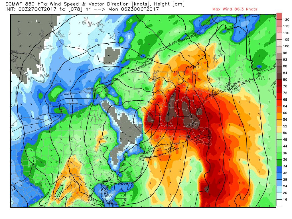
The low pressure system is then expected to tuck northward into Eastern Canada and rapidly deepen – but not before torrential rains (flooding possible in the mentioned areas of New England) and some very strong or damaging wind gusts, possibly over 50mph, in some areas, particularly the New England coasts near Cape Cod and the coastal portions of Maine. There will be with a very strong southeasterly low-level jet with 850mb winds at 80kts or higher. Some potential also exists for strong wind gusts closer to 40mph during and behind the storm system, as the pressure gradient increases over parts of New York, New Jersey and Pennsylvania from later Sunday night into Monday.
Stay tuned over the next 24 hours as we begin to pin down some of the more intricate details of the storm systems evolution, including local and regional impacts as well as timing.