-2")
Cold risks emerging to end November
There is something about this time of year that features more fanfare than the rest. Maybe it’s the approach of winter, or the first surge of cold air into the middle latitudes. Either way, it seems that the first week of November almost always features a bit more drama to the forecast than most weeks, and this year is no different. Forecast models have offered hints this week that the pattern may be set to undergo some significant changes as we look towards the end of Autumn.
As most are aware, the middle latitude pattern in the Northern Hemisphere has been stagnant for quite some time now. Granted, there have been periods of colder than normal air – especially recently in the Northern Plains where departures neared -10 F on a 7 day average. But for the most part, East of the Mississippi River, temperatures have averaged above normal as a Southeast Ridge anomaly has remained stout, owing to La Nina background forcing from the tropical Pacific Ocean.
Things have changed over the last 7 days, however, and will continue to change as we approach the tail end of this week. The Pacific Ocean is reshuffling, as a large, -EPO ridge builds into Alaska. Cold air has already been displaced from the higher latitudes into British Columbia and the Northwestern USA, leaking southward into the Northern Plains states. This cold air will be pushed south into the Plains, Great Lakes and Northeast during the week ahead.

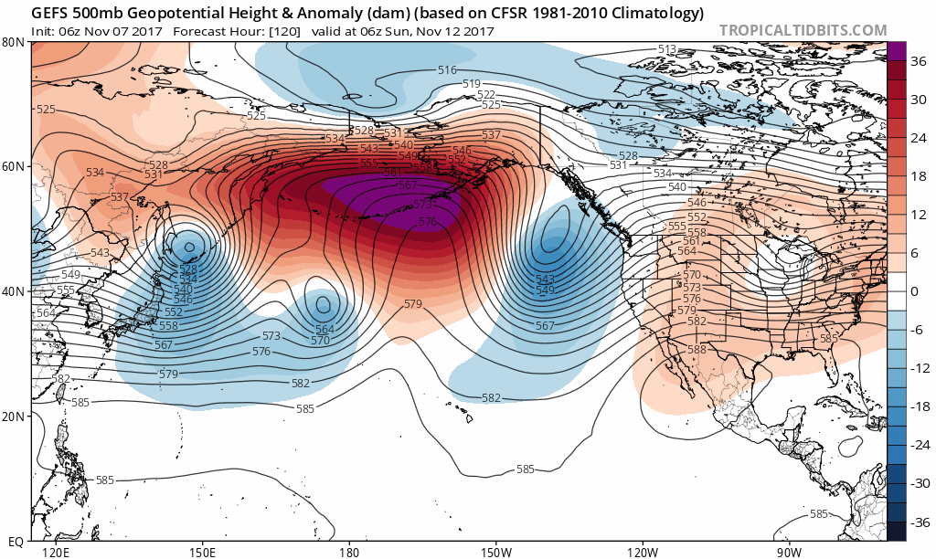
ECMWF ensemble mean showing colder than normal temperatures over much of the CONUS over the next 7 days on average.
But perhaps the most critical piece in the forecast is what is occurring after this cold air surges eastward. While most will be observing a shock to the system in the Northern 1/3 of the USA this weekend, the Pacific Ocean will be undergoing its second retrogression in as many months. This time, a large –EPO ridge near Alaska will retrograde thousands of miles westward into the WPO (Western Pacific Oscillation) region, and then amplify northward into the poles, reaching all the way near the Kara Sea and connecting through the polar regions.
The result of this will be the development of increased high latitude blocking across the North Pole, which is a critical piece of the forecast as we have discussed for several weeks. In addition, the retrogression allows the wave pattern to reshuffle across the CONUS, with a weak ridge anomaly on the Western USA and a well-sourced cold air flow from the Northern Plains into the Great Lakes and Northeast states. If this evolution does occur, the second half of November looks increasingly cold and stormy in these regions.
This will obviously have an impact on energy demand in the critical regions East of the Mississippi River. So how can we begin to figure out exactly how amplified this pattern will be, and how deep the colder than normal anomalies will get? The answer lies in Central and Eastern Canada. If blocking ridges can develop from Greenland into the Davis Strait region, cold air in the arctic regions will be shunted southward. The combination of ridging in the Pacific, North Pole, and Greenland will push cold air well southward and nearly ensure that the Northern 1/3 of the USA is colder than normal to end November.

ECMWF weeklies showing high-latitude blocking over the North Pacific, Kara Sea and Greenland regions, support a cross-polar with a trough over the Eastern US during the Nov 20-27 period.
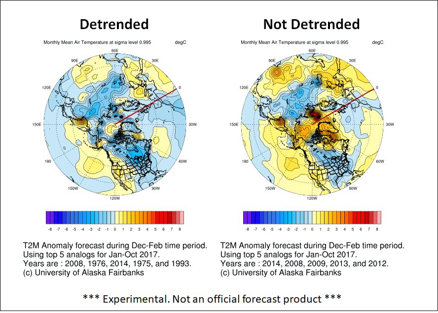
The ECMWF EPS, Weeklies and GEFS are signaling this potential but remain muddled with their pattern ideas as a result of ensemble spread at a long range. When we look to analogs, we can help find more answers and clues; are the analogs in line with our thoughts, or do they point in another direction? Using the top 5 years matching our global background pattern from January to October 2017, the 2m temperature forecast matches closely with long range ensemble ideas, with cold risks into the Northern and Eastern 1/3 of the USA. A +TNA pattern develops as a ridge anomaly remains stout in the North Pacific and transient/volatile ridging in Greenland keeps shots of cold coming through the Northern Plains. Credit to U of AK for the graphics.
The bottom line? While confidence is still low in general moving forward, we are beginning to tie together loose ends to the forecast that are leading us to a conclusion that increased cold risks will emerge in the mentioned regions to end November. These risks are reflected in our latest enterprise forecast packages, maps and discussions. We will continue to revise our thoughts and provide further details on data over the next several days. Stay tuned!
Trackbacks & Pingbacks
1vascular
Comments are closed.