-2")
Light Wintry Mix Today, Some Moderation & Late Week Storm in the Northeast
Good morning! Hope you had a wonderful weekend! After a long duration of very cold temperatures, some pattern changes are on the way this week, finally leading to some moderation in temperature. Unfortunately this will come at a price, as unsettled and wetter weather will be arrive late in the week as well. Clouds will increase after some sunshine early this morning, as a cold front associated with a shortwave trough approaches from the west. Overall this front is lacking moisture and dynamics. Therefore we only anticipate some very light precipitation, as this front moves through the Northrast for a few hours this afternoon or early this evening.
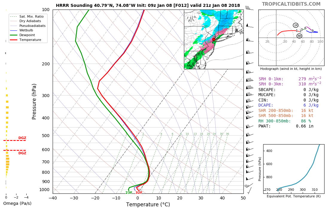
Thermal profiles support much of the precipitation falling in the form of light snow. Any snow accumulations are likely to be under 1”. But a warm nose aloft may also lead to sleet or freezing rain to mix in at times, especially along the I-95 corridor and coastal areas. After the bitter cold this weekend, ground temperatures will be below freezing. So this may lead to icy spots on roadways later this afternoon and early this evening.

HRRR model showing light wintry mix along cold front his afternoon.
Southwest winds will help temperatures moderate into the upper 20s to lower 30s over inland areas this afternoon. Some coastal sections will see temperatures into the middle 30s. If temperatures rise above freezing, it will end the 13 day streak of below freezing temperatures for the New York City region, which would rank as the third longest such streak in recorded history. Skies will begin clearing behind the cold front later tonight. Temperatures will drop into the mid-upper 20s.
High pressure builds back in to the Northeast states thereafter, providing mostly sunny skies on Tuesday. Despite some colder air aloft, downslope northwest winds will support surface temperatures to continue moderate. Highs are expected to be in the lower to middle 40s over a wide area – the warmest day in over two weeks! On Wednesday, high pressure will be moving offshore. This will allow for a southerly flow and further airmass modification, with increasing cloudiness.
A strong ridge builds over the Eastern US as the week goes on. This ridge will cause the next frontal system and upper-level trough from the Midwest to slow down as it approaches Northeast. A deep southerly flow will support temperatures warmer than normal, with highs likely in the upper 40s to middle 50s. Increased cloud cover is expected, and some rain is likely at times as weak waves of low pressure with some moisture move through the Northeast from the end of the week into the weekend. Some areas of patchy fog and drizzle will also likely be around, with warm-air advection increasing on top of colder ground temperatures.
Shortwave energy rounding the base of a trough will cause pattern amplification over the Eastern states this weekend. A strong low pressure system is forecast by most operational and ensemble guidance to develop into the Interior Northeast, and then develop through the Tennessee and Ohio Valleys, allowing more significant precipitation to develop by Friday night and Saturday over parts of th Northeast and Mid-Atlantic regions. Sub-tropical moisture feeding with into this system may support rainfall totals of 1”-2”, with locally higher amounts A combination of heavy rainfall and snow melt may lead to some flooding issues. Some colder air filtering south from high pressure over Southeast Canada may also lead some snow and ice over the higher elevations of the Northeast.

GFS model showing a larger storm system with a myriad of impacts for Friday night and Saturday
Finally, another blast of arctic cold may arrive by Sunday and early next week as the ridge over the Eastern US begins to weaken. Temperatures will return to below normal, but won’t be quite as bitterly cold as it has been over the past two weeks. The pattern is then advertised by most ensemble guidance to feature another ridge over the Western US and trough over Eastern US. So we may have to monitor shortwave energy rounding the trough to amplify into another storm system with more wintry precipitation potential during the Jan 14-18th period. However, currently most model and ensemble guidance keep the mid and upper level flow progressive with drier conditions in the East. Stay tuned for more updates through the week!