-2")

Thursday Briefing: Wintry pattern approaches, interior focused
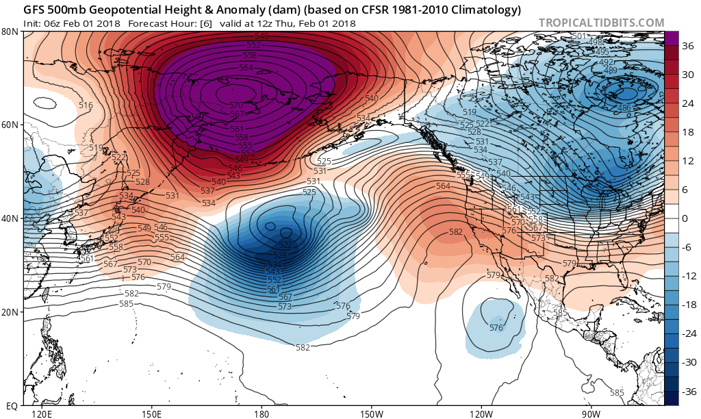
Good morning, and Happy Thursday! A well discussed change to the weather pattern is underway, and the overall atmospheric flow throughout the United States is changing. Warm, Pacific air is on the way out and colder, arctic air is on the way in — especially in the Northern Great Plains and Great Lakes. You can thank this large, anomalous ridge to the Northwest of Alaska for that, as it acts to dislodge arctic air south into Canada and the USA.
The weather pattern that develops as a result of the reshuffling Pacific Ocean will have impacts on everyone – including the Northeast States, as an active weather pattern ensues. Think of it this way – the pattern changes in the Pacific is now “opening the doors” for multiple disturbances to shift eastward into the United States, as energy flows freely into the country.
This wintry pattern that develops, however, looks likely to favor the interior locations of the Northeast and possibly even the Ohio Valley in terms of impacts. Why is that, exactly? The ridge that develops in the Pacific Ocean is modeled to do so very far west compared to the synoptically favorable area for the East Coast to see winter weather. Instead of being centered near the West Coast of the USA, it develops over the Eastern Pacific ocean. This is the main reason why the center of the cold is expected to be in the Northern Plains, and why the storm track could favor the interior Northeast while the coastal plain sees bouts of warmer air.
Over the next several days, a few storm threats are expected to develop. There are a few to highlight:
Friday
A frontal boundary sinks through the Northeast states on Friday morning. After a period of rainfall on Thursday Night, the frontal boundary will approach the region with increasingly cold air. Precipitation may flip to snow in some areas before ending, with minimal accumulations. Temperatures fall rapidly during the morning commute, which could result in icing of standing water on roadways and other surfaces.
Sunday/Monday
A low pressure system develops in the Northeast states late this weekend. Without any high latitude blocking, and with the mentioned ridging developing well in the Eastern Pacific Ocean, there is little mechanism to hold cold air in place along the coast. After some snow early on, precipitation should change to rain for the majority of the coast and I-95 cities. Further inland, however, snow appears likely — specifically in the Ohio Valley, Interior PA, Interior NY and New England.

GFS model showing a large storm system bringing snow, wintry mix or rain over much of the Northeast and Mid-Atlantic by Sunday evening
Next Week
Another storm threat looks likely to develop next week and will take a very similar track to the disturbance on Sunday – similar impacts are expected as well, with the potential for more snow of significance in the Interior locations of the Northeast States.
This is all welcomed news for the higher elevations and Ski Resorts of New England, while the coastal plain appears likely to avoid winter weather of significance through at least mid month, the weather pattern will remain active and colder than normal on average.
More to come today in regards to the pattern through the end of February!
Trackbacks & Pingbacks
2resolve
Comments are closed.