-2")

Tuesday Briefing: Northeast Snow This Weekend Before Big Warmth Next Week?
Good afternoon! Overall the pattern will continue to be progressive until at least Friday. Canadian high pressure will provide mostly sunny skies for rest of today. Temperatures are rising into the mid-upper 30s. Which is few degrees below normal. But the next few days will start see temperature moderate again, as southerly flow develops again. High temperatures on Wednesday will be in the mid-upper 40s. Then highs and Thursday and Friday will be the 50s or 60s, depending on amount of cloud cover.
Some more unsettled weather will return as another frontal system approaches on Thursday and Friday. More scattered showers are expected from time to time. There is a chance that a weak wave of low pressure develops, along the cold front boundary and enhances more moderate rainfall Thursday night into Friday. Behind this cold front another shot of cold air arrives again Friday night into Saturday. Temperatures return to more seasonable levels. Then the weather gets more interesting for rest of the weekend.
Most of model guidance shows another wave low pressure associated with a shortwave trough developing Saturday night over the Mid-Atlantic region. Some of the latest model guidance today, including Canadian and ECMWF models, suggests the trough will amply, along the low track further north. Then precipitation from this feature may make it far northward into Northern NJ, Hudson Valley and Southern New England. At this point, the airmass will begin moderating, as high pressure will be sliding offshore with southerly flow initially. But with the low still track to the south and east, winds may turn more northerly, support some snow or wintry mix in parts of local region.

Canadian model showing a wave low pressure bring a snow and wintry mix to parts of Northern US Saturday night.
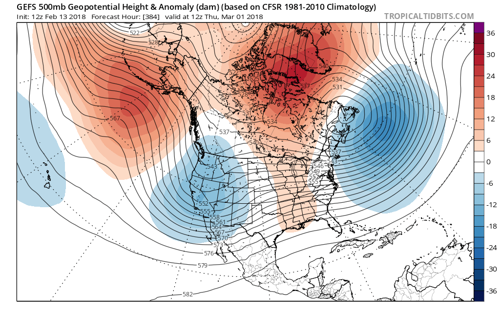
The pattern will still be progressive in the Atlantic. So it possible the flatter and further south solutions GFS and UKMET models, could be correct. So will continue to monitor it. Then next week, a strong ridge will be build near Southeast US, in response to the polar vortex splitting off into Western Canada with trough large trough over Western US. Some weak frontal systems tracking on northern periphery of this ridge may trigger some showers during the next week in the Northeast. But temperatures will likely above normal for most of next week. In fact, some models suggest temperatures could reach 70 degrees or higher in parts of the Northeast.
But this doesn’t mean winter is over for the Northeast US. A cyclonic wave-breaking event in conjunction with the sudden stratosphere warming event, that is just beginning, will be occurring over the North Atlantic. This will initially result an east-based -NAO pattern with a blocking ridge developing United Kingdom or Iceland. Then more disturbance will be move into the Atlantic, on top of the Southeast ridge. This will lead to more wave-breaking and the -NAO block to retrograde into Greenland/Davis Strait, moving into the end of February and beginning of March.

ECMWF ensembles showing -NAO block over North Atlantic retrograding into Greenland, with troughiness underneath over Southeast Canada, resulting in weakening Southeast ridge.
This will cause southeast ridge to flatten and allow for some colder air to intrude into the Northeast US, possibly as early last few days of February, but more likely during the first ten days of March. But there is some disagreement on how the Pacific pattern is also unfold during this time. There indications that some troughiness will be persistent over West Coast, (-PNA) which isn’t ideal for extremely cold air to be transported to Eastern US.
But in this past this strong anomalous blocking over the North Atlantic has proceeded major storms along the East Coast in the past. Also the latest 12z run of GEFS today shows some ridging build into Alaska as the -NAO block retrogrades into Davis Strait. This will support more confluence and cold air over the Northeast US. So we will continue watch for trends in the guidance over next several days carefully, for any major storms. Stay tuned for more updates this week!
Trackbacks & Pingbacks
1comprise
Comments are closed.