-2")

Wintry pattern expected to return by early March
And you thought the worst was over.
For the past few weeks, we’ve been chatting both on our blog and internally with enterprise clients regarding the development of a Sudden Stratospheric Warming event (SSW). In laymen terms, this occurs when a rapid temperature rise occurs in the Arctic stratosphere. In this situation, the stratospheric polar vortex has split in two, and rapid (nearly record breaking) warming has occurred in the stratosphere, particularly in the Arctic regions of the North Atlantic and across the North Pole.
We wrote last week and a few weeks back about the importance of this event – how stratospheric warming, when coupled properly with the troposphere (where our weather occurs) can have a significant impact on our weather by promoting high latitude ridging and blocking. We are starting to see these exact things come to roost on forecast models – and we’ll explain why we have higher than normal confidence in wintry weather returning to the Eastern United States by the first day of March.
It all starts above our heads
With a stratospheric pattern favorable for the development of high latitude blocking, and a properly coupled tropospheric pattern, forecast models have begun to suggest the development of high latitude blocking in the Kara and Barents sea in about 7 days time. It may seem surreal that ridging that many thousands of miles away can heavily impact the weather across the United States, but it is the first signal of a changing pattern in the high latitude North Atlantic Ocean.
Forecast model and ensemble guidance are in good agreement that an anomalous ridge will develop from the Barents Sea towards Greenland over the next 7 to 10 days, with 500mb atmospheric heights much higher than normal moving into Central Greenland by the tail end of February. This ridge anomaly gradually will continue to shift westward, making a move towards the Davis Strait and Central Canada during the first days of March.
This type of retrograding high latitude block, where blocking moves from Greenland westward into Canada, has been associated with some of the more memorable winter weather periods, and large storms in general, in the Northeast United States.

Extra support from the Pacific
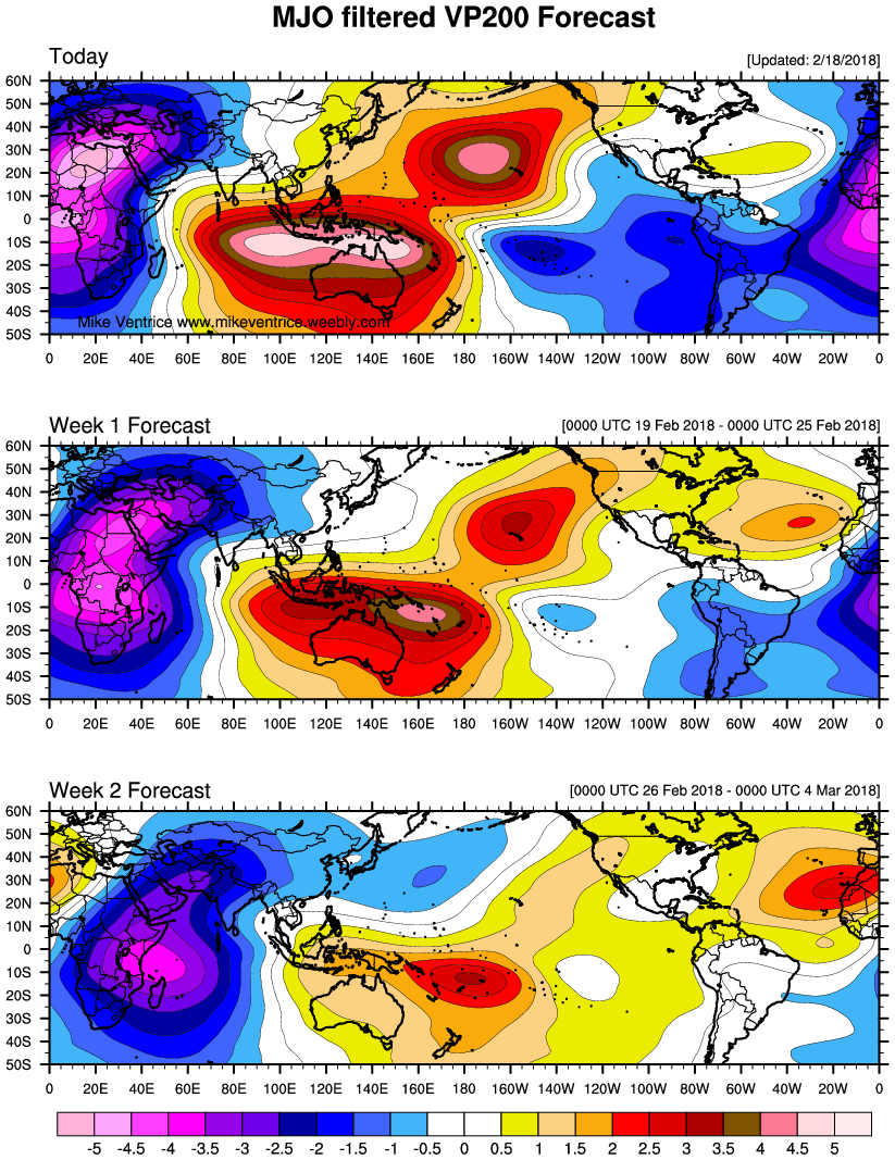
Forecast models showing a certain solution or evolution in the long range is one thing. But how does the story really go? Are all of the pieces really there for this type of evolution? The tropical Pacific Ocean can offer plenty of clues and impact the weather across North America in a significant way. Over the past several days, we have seen the MJO (Madden-Julien Oscillation) traverse from Phase 7 through Phase 8, expected to make a move towards Phase 1 and 2 in the coming days. In fact, the typical RMM diagrams appear to be incorrectly classifying the current MJO phase, as the actual upward vertical motion (blue colors) associated with the MJO has spread from South America and particularly into Africa, which is classically Phase 1. (Image credit: Michael Ventrice)
Historically, analog years with similar base conditions during the month of March — particularly Phase 1 of the MJO — have seen higher than normal heights in the Arctic regions of the North Atlantic (blocking) and the development of lower than normal heights over the Eastern United States with increased opportunities for cold and storminess. And when one combines the fact that the Phase 1 forcing looks to remain for quite a while, and directly assist the Stratospheric Warming event to lead to North Atlantic blocking further increases confidence in a block of nearly historic proportions developing.

A composite of what the “typical” MJO Phase 1 pattern looks like at 500mb. Notice the increased tendency for high-latitude blocking near Greenland and the Davis Straight (Meteo Network).
In addition, we often look to the state of the Pacific jet stream for an idea as to how the weather pattern will evolve. The Pacific jet stream, when dominantly strong or in an “Extended” phase, can overtake the United States with progressive and maritime air. This time, forecast model and ensemble guidance is in good agreement that the jet will move into a “Retracted” phase – with less direct impacts. Instead, a “split flow” may develop on the West Coast of the USA, with plenty of room for amplitude and storminess across the Central and Eastern parts of the country.
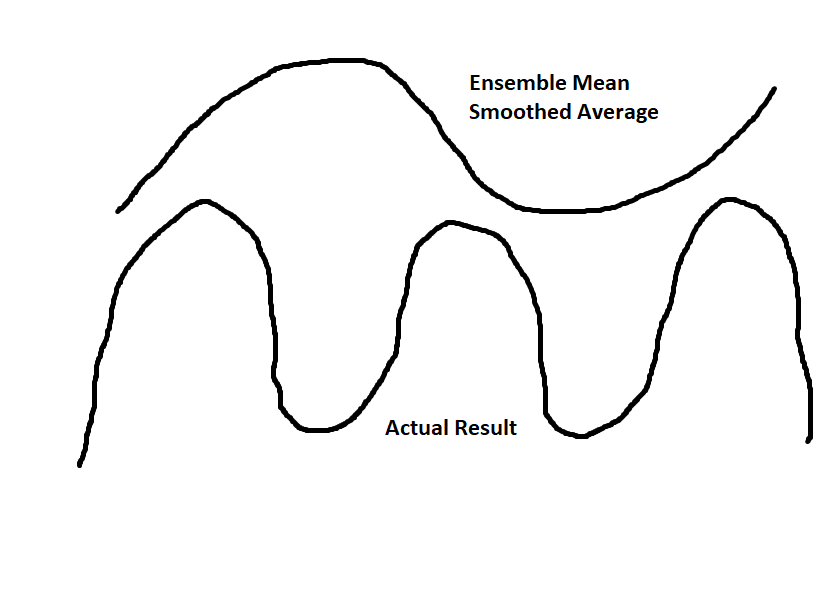
For more context (warning: this will get a bit more technical), sometimes long range ensemble means have the tendency to overly smooth out certain features — especially a series of eastward-moving ridges and troughs in the Pacific — because the individual ensemble members will time them differently. Thus when taking the average, the amplitude gets smoothed out, reduced, and overly broadened. In March, the wavelengths are already particularly short, and when the Pacific Jet is very much retracted, the speed of the jet downstream of its core slows down significantly, which allows a more inherently slow, wavy, and buckled flow. This could lead to some Pacific ridging breaking into Alaska, further dislodging broad, Arctic high pressure southward into Canada, which is then forced to stay there because of the blocking — increasing chaos to the pattern and cold risks for the US.

Today’s 18z GEFS shows the core of a very retracted Jet near Asia, with a slowing, wavy jet downstream. As the wavy jet tries to enter the US, it is forced to buckle, allowing a chaotic weather pattern (Tropical Tidbits)
Imagine the chaos that would ensue from a slowly-moving series of amplified, wavy ridges and troughs in the Pacific “running” into the retrograding Canadian blocking and further slowing down. This is where the idea of a large, slow-moving storm that tracks underneath a large area of blocking high pressure develops. The wave train “running” into the blocking also forces the entire pattern to retrograde, with the initial deep trough in the West buckling off the West Coast, leading to a ridge developing in the Rockies; and with March’s inherent short wavelengths, this further inherently favors a large storm of some sort.
A wintry conclusion
The summation of all of these parts is simple: A colder and wintry pattern appears increasingly likely across the Eastern United States during the beginning of March. Taking this one step further – confidence is much higher than normal at this range given the multitude of factors we discussed. Global and hemispheric pattern drivers are sending off all of the warning signs about the eventual evolution of the pattern.
Exactly how things evolve? That’s still yet to be determined. But common sense tells us that there will be plenty of wintry weather chances, including the opportunity for a “big one” during the first half of March across the Eastern United States.
For now, we suggest enjoying the warmth in the days to come. It won’t be here for long.
This post was written and edited by John Homenuk and Doug Simonian