Posts

2/18 Noon All Zone Update: Very Mild Through Sunday…Cooler on Monday

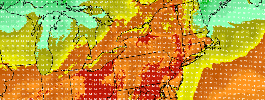
A more pleasant and unseasonably mild afternoon is coming up with sunshine filtering through some high clouds . After a chilly start, temperatures are now rising quickly and will likely get mid-upper 50s to lower 60s over many parts of the region with more southwest winds this afternoon. Somewhat cooler temperatures in upper 40s to lower 50s, will be over extreme northern parts of Hudson Valley and Connecticut. Closer to coast, southwest winds off ocean and sound, may also keep temperatures in the upper 40s to lower 50s.

Read more

Tuesday Overview: Near record warmth thru Wed, then cooler & unsettled

More summer-like warm temperatures are in store for today, as strong, anomalous ridge for this time builds over the region. Mostly sunny skies  are expected today with highs reaching the lower to middle 80s. A deepening low over Southeast Canada will cause winds to somewhat gusty of south later this afternoon. These winds could keep parts of Long Island and south-facing shores a little cooler. But temperatures are still closer to normal for July. A few record highs were broken across the area already yesterday. These are record highs from National Weather Service will be jeopardy again today.

Read more

Premium weekly outlook: Very warm start, cooler air to follow

The anomalous warmth we spoke about last week? It’s finally here! Sunshine will mix with clouds occasionally this afternoon, but by and large, high pressure will remain in control of the weather throughout the Northeast United States. Forecast model guidance suggests that 850mb temperatures of 12-14+ C will surge northward toward the Mid Atlantic states, with southwest winds drawing in warmer air at the surface. Temperatures will rise in the upper 70’s to near 80 this afternoon, with the possibility of some clouds later this afternoon and evening as a weak disturbance passes by. Otherwise, clearing is expected later tonight underneath high pressure and light winds. The interior valleys will drop into the 50’s, but this will be much warmer than the past several nights. Radiational cooling and warm air advecting in the mid levels could cause moisture to be trapped in the low levels — leading to low clouds and patchy fog in spots through Tuesday morning.

Read more

Long Range: Cooler, active pattern ahead for Central US

Far away from the United States, in the equatorial Pacific, a propagating MJO has some ideas as to how the weather pattern will evolve through early October. Okay, maybe that’s not exactly how it works. But the development of an MJO wave will, in fact, aid in the patterns progression over the United States through the end of September. The instra-seasonal traveling pattern of convection more affectionately known as the MJO (Madden Julian Oscillation) has significant impacts on our weather, and this occurrence will be no different. You can read more about the MJO right here.

While the MJO has been stuck in a period of inactivity over the past several weeks, the overall hemispheric pattern has fallen into a bit of a lull. Wash, rinse, repeat has been the overall terminology used. Occasional cold fronts and troughs have brought periods of below normal air to the Central United States while, by and large, the East Coast has remained at the mercy of a large Southeast US and Western Atlantic ridge.

Read more