Good Evening
Since our last update, the Atlantic has racked up more records that it would take too much time to list all of them here. There have been some major changes with our storms, and unfortunately they are not welcome changes. To help get the word out about these potentially catastrophic hurricanes, we have temporarily removed our paywall. We hope everyone stays safe over the next few days during these exceptionally dangerous times.
—————————————————-
Starting off with the most imminent threat to land, we have Hurricane Katia, which is nearing the coast of Veracruz in Mexico. Katia has steadily organized into a hurricane with winds of 105 miles per hour, and recon will be heading into the storm shortly to get a better understanding of the storms strength before it makes landfall later this evening and into early tomorrow morning. While Katia will pose a formidable storm surge and wind threat to the immediate coast, the main threat with the storm will be the threat for life-threatening mud slides triggered by very heavy rainfall as the storm moves inland. Though the storm is relatively small, it still could produce 8-14″ of rain across portions of Mexico, which is more than enough to cause serious issues for locals.

This afternoons HWRF model showing potential rainfall accumulations over portions of Mexico during the next few days. Life-threatening mud slides will be possible as the storm moves inland (Courtesy of NOAA HRD/HWRF)
Katia will likely be very close, if not over Mexico by 1am Central time, so the time the cyclone has to strengthen is very short, but it would not be all that surprising if the current reconnaissance mission found that the storm had indeed become a major hurricane. While it has little impact on the overall threats from the storm, having three active major hurricanes would be a first for the Atlantic. Regardless, Katia should rapidly weaken tonight over the high terrain of Mexico, and should degenerate into a remnant low by tomorrow evening. Overall, people in the path of Katia should be aware of rapidly deteriorating conditions as early 8pm central.

GOES 16 IR shot of hurricane Katia nearing landfall over the Mexican coastline (NASA GHCC)
The next storm likely to affect land is Major Hurricane Jose. Since the last time we looked at Jose it was just a minimal hurricane. Since that time, Jose has put on a very impressive bout of intensification as it was able to hold onto the pocket of low shear just behind Hurricane Irma’s expansive outflow. An earlier recon mission into the storm found that winds have dramatically increased to 150 mph, making Jose an extremely dangerous Category 4 hurricane. With Jose acquiring 150mph winds, this marks the first time in Atlantic hurricane history that back to back storms have attained 150+mph winds. As of this evening, Jose looks rather healthy, despite the storm taking on a more sheared appearance from the aforementioned outflow of Irma. Another recon plane will be in the storm shortly to get an intensity sample, but it seems likely that the storm will at least maintain major hurricane status while it nears the islands.

IR loop of Major Hurricane Jose approaching the Leeward islands with 150 mph winds
Jose may come uncomfortably close to the northern Leeward islands tomorrow afternoon, the same area which Irma quite literally wiped out just a few days ago. With little infrastructure left on the islands of Barbuda and Anguilla, even sustained hurricane force winds will cause massive issues for those left on the islands. This afternoons model guidance took the storm just north of the islands, which would spare them the tight core of the storm, which is good news, but the islands may still experience very heavy squalls, intense wave action, and occasional gusts to hurricane force during the day tomorrow. As I write this, it seems that the storm is really starting to show signs of weakening a bit as the cloud tops begin to warm and the system quickly becoming lopsided, despite the eye remaining quite visible. We will have to see if this trend continues, as this would lead to the storm possibly weakening quite a bit by the time it reaches the islands, which would be very welcome news.
After the storm moves north of the islands, the eventual track of the hurricane becomes very uncertain. As Irma eventually makes landfall somewhere along the Florida peninsula, it will begin to reshape the steering currents over the western Atlantic. This could cause the storm to begin to head east and just south of Bermuda by the middle of next week. At that point, another ridge of high pressure may try to build in overhead and cause the storm to track in an erratic fashion. For this reason, we will still have to keep a weary eye on Jose over the next week or so.

This evenings HWRF model showing winds from Jose coming dangerously close to the islands devastated by Hurricane Irma
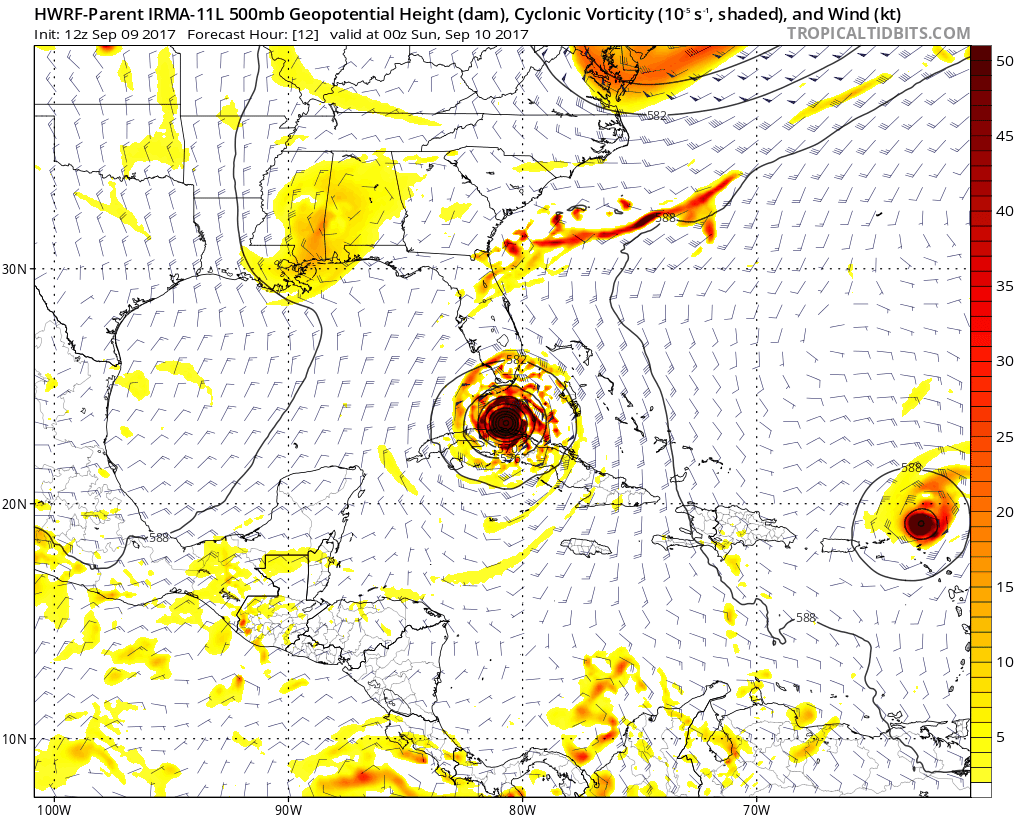
Once again, we move onto Hurricane Irma
Irma has gone through a lengthy eyewall replacement cycle over the past day, which has allowed for the storm to weaken from its 185 mph intensity down to a 155 mph Category 4. Irma is still a very powerful hurricane, and those who think that just because the storm has weakened over the past day or so means that it will be less impactful in the long run is severely mistaken. In fact, there is some data that would suggest that the storm has begun to re-intensify just north of the Cuban coast-potentially back to Category 5 levels. This will have to be confirmed by the NHC in the coming hours.
Over the past 24 hours, the majority of the global models and their ensembles have shifted west, away from SE Florida, and now have SW Florida, and then the western coast in the direct path of this system. Additionally, radar observations show that it is almost certain that the center of Irma will make landfall on the Cuban coastline later tonight. This is a huge change from prior forecasts, and just how long the storm stays over Cuba will determine just how much the storm will weaken. As of this time it seems like Irma will make landfall on the Cuban coast early Saturday morning and could remain over land until later in the day tomorrow. Afterwards, the storm would likely be exiting into a region of extreme oceanic heat content and favorable upper level conditions. Most of the high resolution models, including the new “Deep Thunder” IBM model has Irma rapidly intensifying once it leaves the Cuban coast. I am hesitant to say that Irma will be able to intensify quickly as soon as it leaves the coast due to the fact that this is a very large storm with a very large core, and it may take some time to reorganize, depending on how much damage is done. It is however, likely to at least regain some strength, possibly back to a high-end Category 4 as it nears Florida.

Current GOES 16 shot of Hurricane Irma with 155 mph winds just off the Cuban coast
With regards to the track of Irma, it now seems likely that Miami will not get the brunt of the storm. Areas in SW Florida, including the Florida Keys may see the full extent of Irma on Sunday, with extremely damaging winds, deadly storm surge, and flash flooding. The models have been shifting west all day, and we may very well see more shifts this evening, but the chances are drastically increasing that the west coast of Florida will experience the worst of the storm. Those in the path will have to monitor Irma very closely over the next few days, and stay tuned for further updates as new data become available. We will have more on this developing situation tomorrow for the public.
****When making decisions, always consult the National Hurricane Center, your local National Weather Service, government officials, and local Emergency Managers.****

Latest storm-specific model tracks for Irma, showing a considerable shift away from SE FL (Courtesy of weatherbell)
For more information and posts like this one, make sure you sign up for Premium Forecasts — where multiple detailed articles, videos, and interactives are posted each day. Also, come interact with our staff and many other weather enthusiasts at 33andrain.com!
Have a great evening!
Steve Copertino
-2")


