Posts

Thursday Briefing: Wintry pattern approaches, interior focused

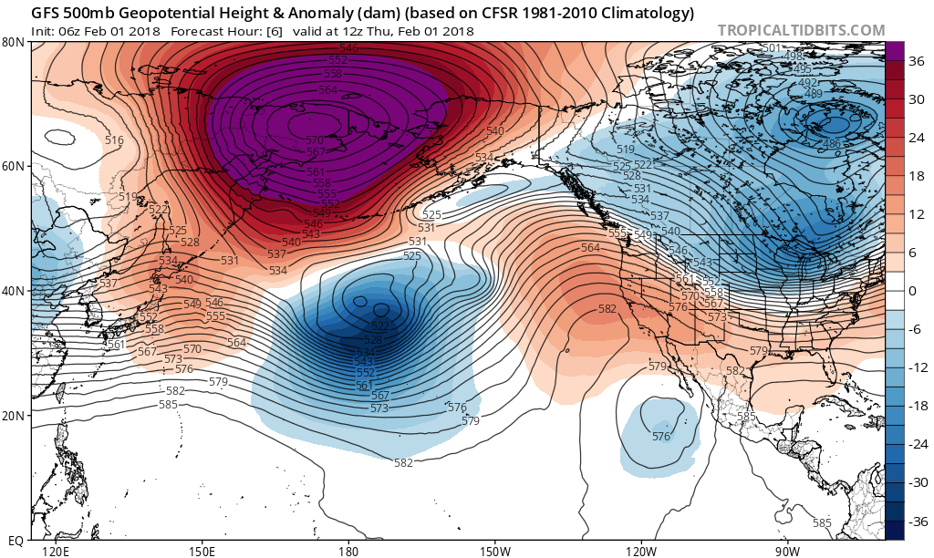
Good morning, and Happy Thursday! A well discussed change to the weather pattern is underway, and the overall atmospheric flow throughout the United States is changing. Warm, Pacific air is on the way out and colder, arctic air is on the way in — especially in the Northern Great Plains and Great Lakes. You can thank this large, anomalous ridge to the Northwest of Alaska for that, as it acts to dislodge arctic air south into Canada and the USA.

The weather pattern that develops as a result of the reshuffling Pacific Ocean will have impacts on everyone – including the Northeast States, as an active weather pattern ensues. Think of it this way – the pattern changes in the Pacific is now “opening the doors” for multiple disturbances to shift eastward into the United States, as energy flows freely into the country.

Read more

3/24 Interior Zones AM Update: Light Wintry Mix Possible Today, More Unsettled Weekend Weather

Happy Friday! Today, a warm front and shortwave will producing some areas of light snow, sleet and/or freezing rain  over parts of Western NY and PA. This activity will be moving into Northeast PA, Southeast NY, Northwest NJ and Northwest CT, around 10am to 12pm noon. No significant wintry hazards are anticipated. But driving on the roads may become a little more treacherous late this morning and early this afternoon.

Read more

Late AM All Zones Update: Snow & Ice Continues For Some Areas This Afternoon

Low pressure currently over Western Pennsylvania will weaken, and as secondary low develops over Southern NJ/Delmarva. This storm system will try to push a warm front through the region. But it will likely stall south and west of NYC, as high pressure positioned over New Brunswick supports more cold-air damming with east-northeast winds over the region.

Read more

1/17 Zones 7 & 8 Update on Ice Threat over Far Northern Interior Areas Today

Low pressure system is currently over the Ohio Valley this morning. As it tracks northeast into the Eastern Great Lakes, it will cause a warm front to approach the region. Areas of light precipitation, have been gradually developing over the region this morning. Warmer air has already moved into the lower and mid-levels of the atmosphere. of So many locations are just seeing rain today.

However, some colder, dry air near the surface and lower levels may be harder to scour out for some higher elevations just north of I-84, and over Northwest CT, This lead some areas patchy light freezing rain that could be mixed some with snow or sleet. No substantial snow accumulations are anticipated. But some slippery travel conditions are possible with a light glaze of ice on roads and sidewalks.

Read more