While we had been tracking heat and severe thunderstorms over the first few months of the summer, the atmosphere was still undergoing a major transition away from El Nino and towards a La Nina. This transition has already resulted in sensible weather changes across much of the country, with a huge heat ridge building in the Central US last month — typical of a La Nina. However, to the despair of some long range forecasters, certain aspects of the transition have not gone as smoothly, and more recent forecast models have trended weaker with the eventual strength of the La Nina over the next few months.
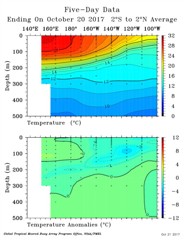
During last year’s El Nino conditions, the trade winds in the Equatorial Pacific were strongly weakened, allowing warm water near Australia to pool eastward. Those trade winds have strengthened over the last few months, which pushed that warm water back to the west, and allowed cooler water to upwell towards the surface. However, climatology favors trade winds remaining a persistent feature — in other words, we are supposed to have east-to-west trade winds blowing warm water towards Australia keeping cooler water near Peru. We can only have a La Nina when those trade winds are consistently stronger than average, and that has yet to be the case this year. For more background on what causes El Nino, La Nina, and the demise of an El Nino, refer to our article from late April.
Read more
-2")


