Posts

Central US cooldown on the way, marking larger pattern change

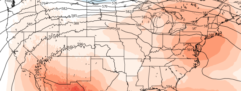
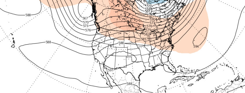
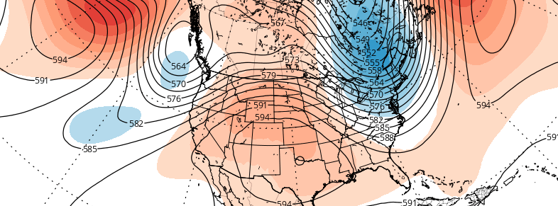
The establishment of a large ridge over the Central and Eastern United States has been well documented. Since July, multiple surges of ridging have kept above normal temperature anomalies rooted from the Plains states through the Mississippi and Ohio River Valleys to the Eastern Seaboard. With varying degrees of intensity and length, these above normal anomalies have slowly taken a hit, lessening in intensity from west to east. This will take on a larger meaning this weekend, as a large trough drives into the Plains and Mississippi River Valley, bringing a widespread area of below normal temperatures into the Central US amid a changing pattern.

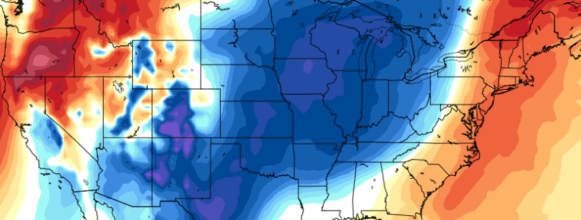
While temperatures won’t necessarily be “cold” by sensible weather standards, they will be a few degrees below normal in many locations, and several degrees below normal in some. This is statistically significant for this time of year, especially considering overnight temperatures could fall into the 50’s in many locations. When one considers the change in temperature from the past week, the significance becomes apparent — a 30 degree temperature differential in some locations.

Read more

Premium: More heat, storm chances on the horizon

The atmospheric pattern so far, for the majority of Spring and now into the first week or two of calendar summer, has been a bit of an enigma. There have been transient bouts of warmth, with showers and thunderstorms, but cooler periods have followed. For the most part, our area has avoided widespread or organized severe weather events as well. Over the next few weeks, that pattern looks to slowly undergo some changes.

While these changes aren’t expected to be sudden or dramatic, the gradual transition will certainly have an impact on the weather that our local area experiences. In todays premium post, we break down what is driving the changes to the pattern, how we anticipate it will evolve, and what the effects on our sensible weather will be — including temperatures, precipitation, and hazardous weather opportunities.

Since the Spring, the pattern has been dominated by a recurring theme of troughiness in Southeast Canada. While ridging has become established over the Central United States, at times, higher latitude blocking — and, often times, an amplified northern jet stream — has allowed for troughs in Southeast Canada to impede the northward extension of that ridging.

Read more

Atmospheric pattern may support periods of heat by mid July

Warmer temperatures have returned this week, with highs reaching back into the middle and upper 80s. But the pattern still has yet to change to support any type of heat waves — and it doesn’t look like it will over the next week or so. Another cooling trend during the latter half of next week will bring an end to the month of June. For those who are looking ahead to the warm, hot days of summer, or trying get a heads up on any excessive heat for crops — this may escalate the amount of questions in regards to how this summer will turn out. Are there any changes expected to the atmospheric pattern over the next few weeks?

A ridge amplifying over the West Coast early this week will lead to a large trough over much of the Central and Eastern US for the later half of this week and into the July 4th holiday weekend. This pattern evolution can be largely attributed current +PDO influence and MJO progression during neutral ENSO conditions thus far this meteorological summer. This pattern should continue for another couple of weeks, before any significant changes take place to support more heat over Northeast US..

Ahead of this large trough this week will be a slow-moving cold front that could cause some showers and thunderstorms with possibly some heavy rainfall from late tonight through Wednesday. After this cold front moves passed the region, high pressure builds in briefly for Thursday with temperatures near average in lower or 80s. Then more embedded disturbances moving around this trough could provide more chances for showers and thunderstorms on Friday and then possibly over the July 4th holiday weekend.

Read more

Premium: Cooler than average trend to persist through June

While many long range forecasts have been banging the “heat drum” for several weeks now, that heat has yet to materialize in any fashion throughout the Northeast United States during the first few weeks of meteorological summer. The next few weeks, additionally, are unlikely to offer any chances for prolonged heat or above average temperature departures.

In fact, there are growing signals, from both the hemispheric pattern evolution and climate phenomena, that below normal temperatures and unsettled conditions may return to the area to close out the month of June.

Read more