Posts

Complex setup, powerful coastal storm to graze area

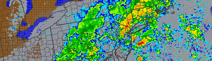
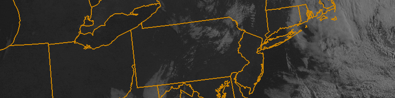
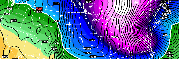
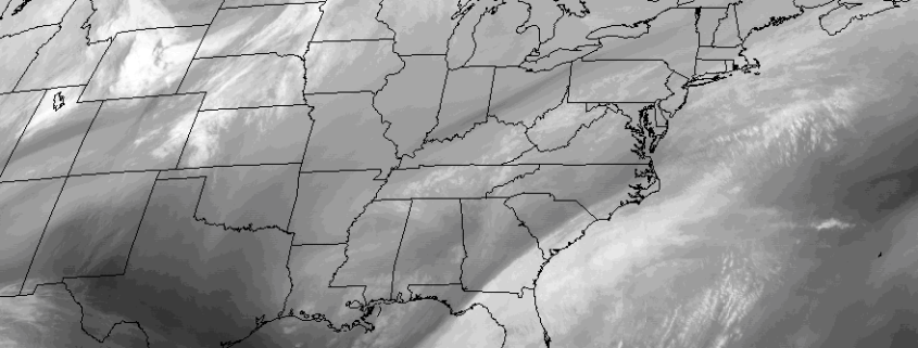
An anomalous and powerful coastal storm is likely to graze the area late this weekend and early next week, with a tremendous breadth of precipitation as the center of low pressure passes hundreds of miles to our east in the Atlantic Ocean. Forecast models have come into better agreement on the evolution of  a large and intense mid and upper level system, with an impressively strong trough moving from the Southeast States to a position southeast of New England by Monday.

Read more

Drought buster: Heavy, tropical rains possible this week

A stretch of pleasant weather over the past several weeks will finally come to an end, as tropical moisture and multiple coastal storm systems bring an increased likelihood of rain.

The pleasant weather, while welcomed, has brought upon Moderate Drought conditions throughout much of New Jersey and New York, with the Department of Environmental Protection recently issuing  a Drought Watch. The rains this week will put a significant dent in the deficits we have built up since late-summer.

Forecast models are in good agreement that a frontal zone will sink toward the area on Tuesday, with enough forcing and lift for precipitation to develop. Making matters even more interesting, a southeasterly flow will aid in the expansion of tropical moisture along much of the East Coast. As all of this occurs, models suggest a low pressure system will develop near the front, aiding in heavier and more widespread rainfall on Wednesday.

Read more

Pleasant midweek weather takes hold

After several days of unsettled conditions, pleasant weather will take hold once again during the middle part of the work week. High temperatures which reached barely into the lower 60’s on Monday will moderate a bit on Tuesday, with high pressure remaining in control. Warming temperatures in the mid levels of the atmosphere, partly cloudy skies and light northwest winds will mean temperatures rising into the mid to upper 60’s in many locations. As always, it will be a bit cooler near the coast. But the light offshore winds will keep any major seabreeze or marine impact at bay (no pun intended) for the time being.

Wednesday looks warmer than its predecessor, with further airmass modification and warmer air aloft. Highs may approach the 70 degree mark in the usual warm spots — and light winds with partly cloudy skies will keep it feeling warm and pleasant for the majority of the day. The same may be true for most of Thursday, although increasing clouds late in the day will be a harbinger of things to come as a large and energetic upper level trough begins to dive southward from Canada into the Great Lakes and Ohio Valley late in the day.

Read more

Significant storm possible this weekend, details uncertain

Here we are again. Over the last day or so, forecast models have begun to come into agreement on a potentially significant Nor’Easter developing late this weekend into early next week. With a polar upper level low and associated shortwave energy dropping southward from Canada into the Great Lakes, a storm system will develop off the Northeast Coast of the United States on Sunday. But the devil, as always, is in the details. The exact positioning, orientation, and intensity of the mid level energy as it moves toward the coast will have significant impacts on where the coastal storm develops and how strong it is.

Not surprisingly, forecast models have been struggling to pin down the exact track and location of the aforementioned coastal low. Once it develops off the Northeast coast, there is good agreement on one thing: The storm will deepen rapidly. But the location where this occurs depends greatly on the track of the mid and upper level atmospheric energy. Some forecast models take this energy farther north, through New England, and develop the surface low too far north to affect our area. But others track it farther south, allowing the low to develop off the coast of New Jersey and bring snowfall to our area Sunday into Monday.

Read more