Posts

SPC Outlooks will change starting this Wednesday

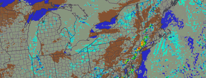
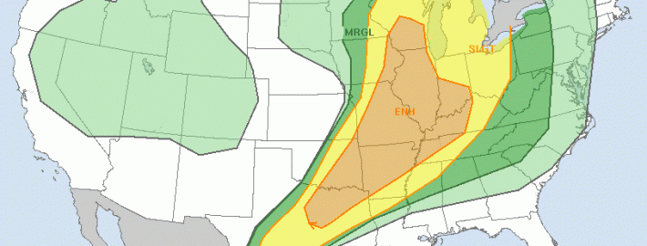
The Storm Prediction Center has used the same risk categories for a large part of most of our meteorological careers. Although they have adjusted the probabilities, percentages, and yes even the colors — the categorical risk areas have remained the same. On this coming Wednesday, that will change. The Storm Prediction Center currently uses a simple categorical risk system which highlights the potential for severe thunderstorms across the country. The risk areas of Slight, Moderate and High are triggered by percentage chance of a type of severe weather within 25 miles of any point. And while the newer outlooks also highlight the potential for general non-severe thunderstorms across the country, Wednesday will mark a dramatic change in the way these outlooks are viewed and understood.

The main change will be the addition of two risk levels, both falling on opposite sides of the “Slight” risk of severe thunderstorms. “Marginal”, a new risk category, will highlight the potential for severe thunderstorms that includes a 5-10% chance of wind and hail and a 2-5% chance of tornadoes — but does not trigger a Slight Risk. “Enhanced” falls on the other side of “Slight”; in other words the risk levels are enhanced (30-45% risk) but not organized or widespread enough to trigger a Moderate Risk.

Read more

Strong storms possible with big cold front Thursday

A significant cold front moving through the Central United States will approach the region late on Thursday evening, bringing a wind shift and drop in temperatures both aloft and at the surface. The cold front is associated with a major mid level disturbance, which will shift from the North Central US into Southeastern Canada. As the front shifts through our region, moderate instability and favorable wind fields could support the development of strong/severe thunderstorms.

The Storm Prediction Center has placed parts of the area in a Slight Risk for severe thunderstorms on Thursday afternoon and evening, citing a risk for strong winds. In addition to the winds, unseasonably high precipitable water could support heavy rain and flooding in any storms that shift through the area Thursday evening. But the severe weather threat isn’t as straightforward as it may seem.

Read more

Severe thunderstorms likely this afternoon and evening

A morning sounding, gathered via data from a weather balloon launched at the NWS in Upton, New York showed a developing unstable environment — and sufficient wind shear for organization of strong and severe thunderstorms. An approaching disturbance in the mid and upper levels will aid in the development of strong to severe thunderstorms, which will be fueled by a moderately unstable environment throughout the area. Organized thunderstorms will be capable of producing strong and damaging winds, frequent lightning, and very heavy flooding rains.

Additionally, an increase in storm relative helicity and low level shear suggests the potential may exist for downbursts and isolated tornadoes. If individual supercells can form, this threat could be somewhat greater. Storms are expected to develop over Eastern Pennsylvania this afternoon and shift eastward through NJ, NYC, SE NY and CT. With strengthening wind fields, just above the surface, any storm could produce the aforementioned damaging winds and severe-weather impacts.

Morning sounding from the weather balloon launched at Upton, NY.

Morning sounding from the weather balloon launched at Upton, NY.

Read more

Severe weather, heavy rain likely Monday

As an expansive, powerful upper level low will shift eastward from the Great Lakes toward parts of the Ohio Valley late this weekend into early next week. Immediately, the southerly flow ahead of it — and the nature of the upper level low shifting so far south this time of year — caught forecasters eye for severe weather potential in the Northeast US.  The combination of warm, southerly flow ahead of the approaching upper level low will at least support the potential for heavy rain, while the severe weather setup has become more complicated.

Sunday evening, the first “threat” for thunderstorms will develop over Pennsylvania and Western New York state, where lift for thunderstorm development and instability will support severe storm potential. These storms will move eastward toward parts of our area later tonight, but are expected to weaken over time as they lose support for organization. On Monday, however, things will change — as southerly flow strengthens in our area, shear aloft increases, and lift develops during the afternoon to aid in the development of thunderstorms. Figure 1 shows the approaching upper level system.

Figure 1 - NAM model showing the upper level system shifting toward the area on Monday.

Figure 1 – NAM model showing the upper level system shifting toward the area on Monday.

Read more