Posts

Manhattanhenge returns, cooler air in control

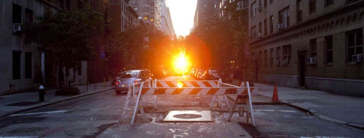
Just before sunset tonight, the sun will line up with Manhattan’s street grid in a marvelous and picturesque alignment known as Manhattanhenge. Crowned by Neil deGrasse Tyson in reference to Stonehenge, the alignment of the sun on Manhattans streets draws thousands of photographers and tourists during the multiple times which it occurs each year. The phenomenon would occur on the Summer and Winter equinoxes if Manhattans grid was aligned perfectly north to south, but instead the grid is tilted by about 30 degrees east — so it occurs on odd days throughout the year.

Tonight, just after 8pm, the sun will set between the tall buildings of New York City — visible if you are facing west. The best views are typically on the major cross-streets of 14th, 23rd, 34th, 42nd and 57th. The sun will set below the horizon at 8:16pm. Today’s Manhattanhenge will only be a half-disk sun — but Friday’s will feature a full disk sunset down the center of the aforementioned east-side streets.

Read more

Backdoor front brings clouds, cooler air

For the fifth time this Spring, a well defined backdoor cold front has swung southwestward from New England and brought marine air into our area. On the heels of three warm days in a row, with temperatures in the 80’s to near 90 on the last two days, the backdoor front gained steam initially in Maine and moved through New England on Tuesday. By Tuesday Night, the front progressed past New York City and Wednesday morning it was south of Philadelphia. The front featured a dramatic thermal gradient, with temperatures now in the 50’s and 60’s in areas where they were in the 80’s on Thursday. Northeast winds and cooler, more damp air were to blame as clouds infiltrated the area as well.

The culprit in the development of the backdoor cold front is a persistent trough from Eastern Canada into New England and the Northwest Atlantic Ocean. This feature has reappeared several times this Spring season, and continues to bring an abrupt end to any warmups which surge into the area from the Central US. The front will eventually weaken later this week, but troughing is expected to maintain its hold on the areas weather — keeping any major warmups back into the 80’s at bay for the time being.

Read more

Strong storms Tuesday, backdoor front Wednesday

It has been the season of backdoor cold fronts so far this Spring, and yet another one is poised to move southwestward from New England during the middle part of this week. For the time being, our area is nestled just to the south of the backdoor frontal boundary. What  this means for Tuesday is continued, if not enhanced southerly flow and very warm temperatures. Highs in the upper 80’s to lower 90’s are likely throughout the area — and warm temperatures are even possible down to the beaches with an offshore wind direction.

By Tuesday afternoon, however, increased support for lift along the broad frontal zone will increase the chances for the development of showers and thunderstorms. With moderate instability in place and marginally supportive wind fields, strong to severe thunderstorms are a possibility. Dropping from the northwest, these storms will be on the periphery of good upper level support, and may make it as far as the area beaches while maintaining strong to severe intensity. Namely, dangerous lightning and strong winds are a possibility within these storms.

Read more

Unsettled weather continues with more storms Friday

In the wake of a severe weather event which produced multiple reports of large hail in New Jersey and New York on Thursday, showers and thunderstorms are once again expected on Friday afternoon. The culprit is a developing upper level system, which will meander near the area (and the entire Northeast US) through this weekend.  Although the storms on Friday won’t be severe (we’re lacking many ingredients including moderate to strong instability and wind shear), they could still bring periods of heavy rain and thunder.

To start, however, Friday will be characterized mostly by low clouds and fog. Drizzle should continue into the late morning hours with the marine air entrenched in the region. But as it begins to burn off in the early afternoon, some peaks of sun are expected to filter in and out of the clouds, and daytime heating will help to trigger some storms within an environment favorable for shower and non-severe storm development. “Self-destructive sunshine” is a term used by meteorologists for days like this — the appearance of the sun just fuels additional showers and storms.

Read more