Posts

Unsettled weather, and the return of the Perseids

20130807-100653.jpg

7 days into the month of August, and the general feeling in the air has been more autumn-like than anything else. How many times in the past several years have we been able to say that? Well, very few is the simple answer — Augusts have averaged much warmer and more humid than the first week of 2013’s. That being said, these things have a funny way of balancing themselves out. “Climo (climatology) will always catch up” is the famous saying throughout meteorology. We’ll see if it applies this month.

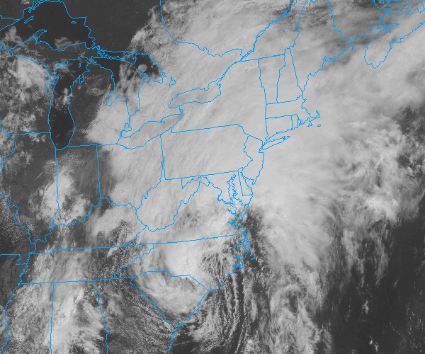
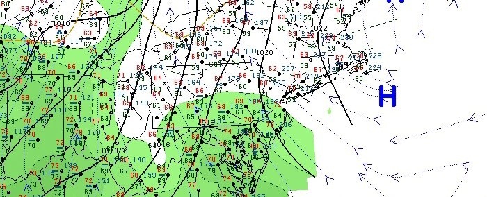
One thing is for sure, the low humidity and sun-filled weather of the past several days is on the way out. It’s hard not to notice it already this Wednesday morning. The culprit? A high pressure system (the one responsible for the gorgeous weather) is slipping offshore. As a result, surface winds have turned southeasterly — off the ocean waters. Moisture will slowly increase over the next 12-24 hours. The rain may hold off until the evening on Wednesday, as the atmosphere still needs some work (namely more moisture content) to be able to produce precipitation.

By Thursday, the atmosphere will have moistened up – and an approaching warm front will provide isentropic lift and promote the development of showers and thunderstorms. Much of the same is expected through Friday, with precipitable water values approaching 2″ by Friday near and ahead of a cold front.

Some more pleasant weather is on the horizon this weekend behind the front, but we have a few days of cloudy and stormy conditions to get through before we can enjoy the warm sun once again.

Perseid’s return to light up the night sky: The annual Perseid meteor shower returns over the next week – and stargazers will be excited to learn that this years shower once again looks promising. The shower actually began a few days ago, and will continue to increase in numbers each night until a peak between August 11th-13th. Clouds will obstruct any meteor viewing through Friday, but this weekend could offer some prime-time viewing. Stay tuned for more updates as the peak approaches!

Forecast: Unsettled weather returns

After a splendid Saturday which featured plenty of sun and warmer temperatures, unsettled weather has returned to the forecast during the second half of this weekend. Multiple disturbances moving through the atmosphere aloft will touch off clouds, showers and the potential for thunderstorms throughout the area on Sunday afternoon. Much of the same is forecast on both Monday and Tuesday, although the sun should make an appearance at some point on both days. Check out the express forecast below, and have a terrific Sunday!

Rest of Today/Tonight: Mostly cloudy with a chance of showers. Some breaks of sun possible throughout the afternoon. Highs in the upper 70’s. West/southwest winds around 15 miles per hour.

Monday: Partly cloudy and warmer, with a chance of showers and thunderstorms particularly in the afternoon. Highs in the mid 80’s. Southwest winds around 15 miles per hour. Some of the storms could produce heavy downpours. Feeling more humid with rising dew points.

Tuesday: Mostly cloudy with highs in the lower 80’s. A chance of showers and thunderstorms. Southwest winds continuing around 15 miles per hour.


Forecast: Unsettled week lies ahead

Unsettled weather has gripped the areas weather pattern once again, after the remnants of Tropical Storm Andrea provided the area with 4-5 inches of rainfall. Multiple perturbations and individual disturbances will move through the Northeast US over the next several days, providing the chance for unsettled weather essentially throughout the week. After a prolonged period of clouds and showers on Monday, some clearing is expected on Tuesday with temperatures warming into the upper 70’s to near 80. By the afternoon, however, scattered showers and storms will return to the forecast. There could be a break in the action by midweek (Wednesday most likely), before chances of more steady rain return by Thursday and Friday.

Visible satellite imagery from the afternoon of June 10th, 2013 showing clouds and unsettled weather throughout the Northeast US.

Rest of Today (Monday): Cloudy with showers. Rain could be heavy at times. Highs in the lower 70’s. East winds around 10 miles per hour. Chance of precipitation 100%.

Monday Night: Cloudy with showers likely. Some thunder is also possible. Low temperatures falling into the mid 60’s. Southeast winds around 10 miles per hour. Chance of precipitation 100%.

Tuesday: Partly cloudy early and warmer with highs in the upper 70’s to lower 80’s. Showers and thunderstorms developing by afternoon. West winds around 10 miles per hour. Chance of precipitation 60%.

A look ahead: A break in the unsettled weather is possible around the middle of the week (Wednesday). But as another disturbance moves towards the Northeast/Mid Atlantic states by Thursday and Friday — the likelihood of showers and storms will increase once again. Behind this disturbance, early indications are that next weekend will feature dry but cooler than normal conditions.

Tropical rains continue, messy PM commute likely

[alert type=”error”]Flash Flood Watch in effect through Saturday | Hazardous Weather Briefing for T.S Andrea is now available. [/alert]

Tropical Storm Andrea, which still had maximum sustained winds of 40 miles per hour and was located over South Carolina as of 11am, was bringing widespread tropical moisture and rainfall to much of the East Coast early this afternoon. As she continues to move north and east (and eventually become post tropical) the center of the low pressure will pass off the Mid-Atlantic coast and then over or near Cape Cod on Saturday. To the northwest of the surface low, heavy tropical rains are expected — which places our area in a high probability for a prolonged heavy rain event.

Tropical Storm Andrea, as seen on visible satellite June 7th, 2013. Andrea was moving northeast and continued to pack maximum sustained winds of 40 miles per hour.

Tropical Storm Andrea, as seen on visible satellite June 7th, 2013. Andrea was moving northeast and continued to pack maximum sustained winds of 40 miles per hour.

Through Tonight: Heavy rain likely, especially after 2pm. A thunderstorm is also possible. Temperatures topping out in the upper 60’s this afternoon, but only falling into the low 60’s overnight. East winds around 15 miles per hour. A washout — bring an umbrella and a rain coat if you have to head out.

Friday PM commute will be a messy one: With a few inches of rain already recorded in the area, and the heaviest rain expected to begin around the evening commute on Friday, you can expect delays (some major) on roads that do not handle the rain well. Flooding is expected on low lying roads and poor drainage roads. Drive carefully in the heavy rain as well, as visibilities will be reduced especially on highways.

Looking ahead: The forecast remains wet through Saturday morning, but some clearing is possible by Saturday afternoon as the system moves out of the area fairly rapidly. Showers and maybe a thunderstorm are still possible through Saturday evening. Sunday looks to be the winner of the weekend, with highs in the upper 70’s to low 80’s and partly cloudy skies.