Posts

Weekend storm system will start wintry in Northeast

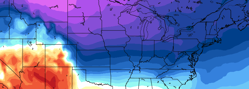
An arctic airmass will drive southeastward from Canada and into the Northeast United States late this week, bringing with it the coldest temperatures in quite some time. In fact, the arctic airmass is part of the polar vortex — yes that one which we discuss all too often — a piece of which is dropping southward into New England. This isn’t necessarily unusual in winter, but it certainly is this time of year — some of the temperatures being modeled at 850mb (5000 feet) would challenge record lows for this time of year.

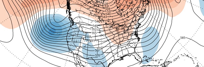
Nevertheless — the polar vortex swinging through will, after it brings some brutally cold air, begin a quick departure. This is occurring mainly due to a lack of high latitude blocking. In other words, there is no feature to “keep” the polar vortex from shifting away, and back to where it typically stays. There was an impetus to bring it here, the Alaskan ridge which we discussed at length the past several weeks.

Read more

Aleutian ridge, cross polar flow will lead to more wintry pattern

A pattern change discussed for several weeks is already underway, and will kick into high gear over the next several days. A much discussed ridge over Alaska will build northward later this week towards the North Pole. We call this a “poleward reaching” ridge — effectively named — as it develops towards the Arctic and polar regions from the North Pacific and Alaska. This is important for several reasons; but mainly because it helps to dislodge cold air which is typically bottled up in the arctic regions.

The ridge north of Alaska will continue to build this weekend into early next week — a very anomalous feature, even globally — and cold air will surge southward on its east end into the West and Central United States. This very same cold will eventually seep eastwards towards the Ohio Valley and East Coast. It won’t come all at once, in fact it likely will be in multiple rounds, but the cold will be anomalous.

Read more

Premium: Late month pattern change likely to be gradual

As discussed in the winter forecast, the stratospheric polar vortex has been weakened since late October. A wave-breaking event, mainly induced by a large ridge in the Kara Sea, has resulted in 100mb heat fluxes remaining above average. We still believe the polar vortex is likely to be weaker and more disturbed going into this winter, especially compared to the past several years.  However, some resistance from the polar vortex and tropical forcing influences will likely result in more gradual step down into pattern changes over next several weeks.

While westerly zonal winds have decreased to below average levels, a wind reversal or easterly winds aren’t being forecasted, particularly around 10mb and 60N. EPV at 10hpa also appears to shift from being poleward to more equatorward by the third week of November. Despite being severely disrupted; these winds allow for the polar vortex to remain quite large and profound over the high-latitudes. This will likely result in more neutral modality with the AO/NAO over next few weeks.

Read more

Premium: November Outlook and pattern evolution

Changes in the stratosphere have been well documented and explained over the past several days and, despite the fanfare, have not yet had their dramatic impact on the weather pattern across the Continental United States. But in due time, they will, and it will likely begin — ironically — at the very start of the month of November. A much more amplified pattern in the higher latitudes will kick off changes in the Pacific Ocean, starting with a much more amplified Pacific Jet.

This Pacific Jet stream will flood the United States with warm, maritime air as a large vortex forms in the Gulf of Alaska. This is an important development for several reasons moving forward, but in the interest of November alone, its short term significance will be verified by a surge of much above normal temperatures into the Central and eventually Eastern United States.

Read more