-2")
As a new feature to the blog, this Winter Storm Archive page will serve as a running archive for each winter storm that impacts the area during the winter of 2011-2012. The archive will be updated as the winter progresses, in a non-official manner. Please note that links from 2011-2012 will guide you to our old blog. [memberful_buy_subscription_link plan=’9040-premium-member’][/memberful_buy_subscription_link]
Winter 2012-2013
Summary: Winter 2012-2013 will likely be remembered as a two-piece winter, which featured bookend storm systems that technically produced snowfall that was “out of season”. Winter began early, on November 7th. Just a week after the area was devastated by Hurricane Sandy, a significant nor’easter moved close to the New Jersey coast once again bringing significant snowfall to portions of the area. Thereafter, winter took a brief hiatus. Above normal temperatures dominated through January and, despite a few light snow events, snowfall remained generally absent through February. Major changes in the atmosphere, however, had already begun. Teed off by a stratospheric warming event, winter returned with a vengeance by February with a Blizzard which ravaged areas from New York City to Southern New England with significant snowfall amounts. Another storm system in late February was followed by an early March and late March snowstorm. Below normal temperatures and above normal snowcover in March was a shock to the system — an uncommon sight in the area the past few years. The winter ended with around average snowfall across most of the area, but above average to much above average snowfall was observed from Southwest Connecticut into Southern New England.
- March 24-26, 2013 Snowstorm | Low Impact
- March 6-8, 2013 Snowstorm | Moderate Impact
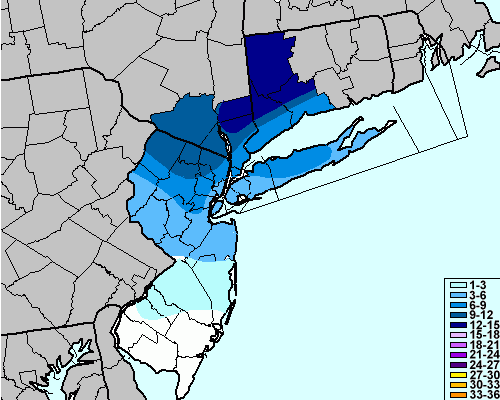
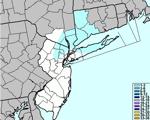
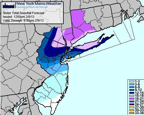
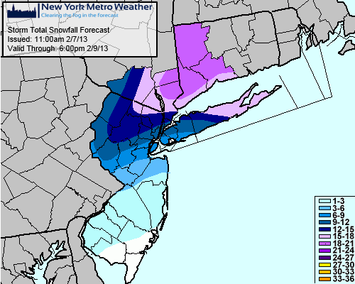
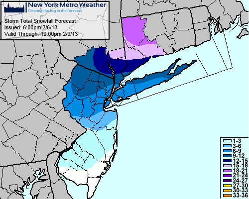
- February 8th, 2013 Snowstorm | High Impact
- November 7th, 2012 Snowstorm| Moderate Impact
Winter 2011-2012
Summary: Winter 2011-2012 was one of the least-snowy winters in the history of NYC, NJ, and CT. The pattern throughout the winter was dominated by a lack of blocking over the polar regions, record low ice and snow levels, and a lack of systems even potentially capable of producing snow. The first snow of the season came at a historically early date — October 30th. This would be the one and only significant snowstorm of the cool season, and it wouldn’t even officially count towards the snowfall totals in calendar winter. The only marginally impactful storm came in late January as a southwest flow event, but this remained mostly relegated to the interior with lesser amounts near the coast. Most official reporting stations came in with seasonal snowfalls under 10 inches, and some under 7 inches. This winter will certainly be remembered as a warm and snow-less one in the NYC area — another anomalous event in a string of anomalous weather events which had been occurring for the last year and a half (the previous winter featured some historically high snowfall amounts).
- Long Range/Pattern Discussions
- January 20th-21st, 2012 Snowstorm | Moderate Impact
- Storm Total Snowfall Forecast (Final) (Issued January 20th, 2012)
- Storm Total Snowfall Forecast (Issued January 19th, 2012)
- Storm Total Snowfall Forecast (Issued January 18th, 2012)
- Snowfall Probabilities Table (Issued January 20th, 2012)
- Snowfall Probabilities Table (Issued January 18th, 2012)
- Storm Analysis Article (Written January 18th, 2012)
- Storm Alert Article (Written January 19th, 2012)
- Storm Update/Live Article (Written January 20th, 2012
- December 7th-8th, 2011 Snowstorm | Low Impact
- Final Storm Total Snowfall Contour
- Final Storm Total Snowfall Plots
- Storm Total Snowfall Forecast (Issued December 7th, 2011)
- Storm Total Snowfall Forecast (Issued December 6th, 2011)
- Snowfall Probabilities Table (Issued December 6th, 2011)
- Storm Analysis Article (Written December 6th, 2011)
- Storm Alert Article (Written December 7th, 2011)
- Storm Update/Live Article (Written December 8th, 2011)
Leave a Reply
Want to join the discussion?Feel free to contribute!