Outlook Maps
Week 1
Week 2
Week 3
Extended
Model Data
GWHDD Numbers
Precipitation
Discussion
Week 1
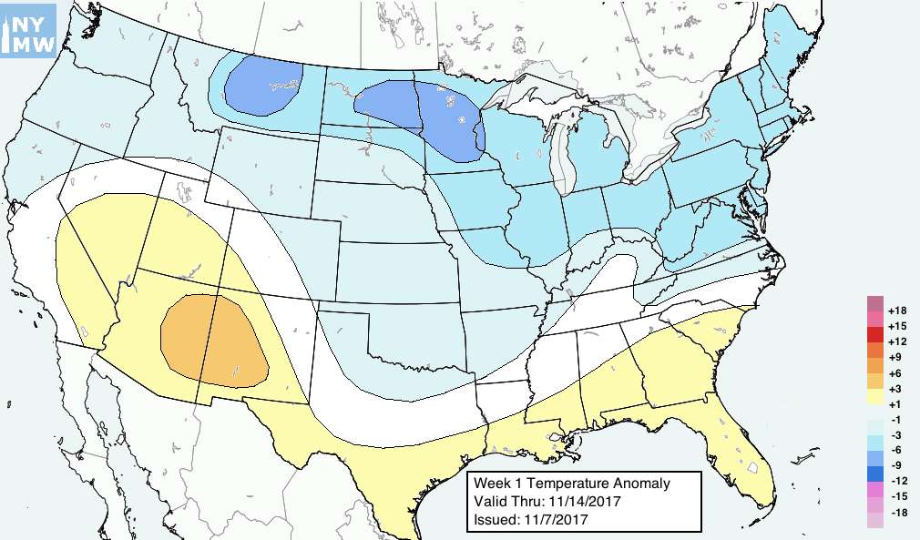
Colder adjustment over Northeast and Great Lakes with significant cold anomalies now expected to linger into the end of the period. Reduced anomalies over N Plains with period change. HDD net change upward in East.
A large, anomalous -EPO pattern will develop across the Northern Pacific during this week. A huge ridge will build west of Alaska in the North Pacific Ocean, extending well northward into the higher polar latitudes and disrupting the flow of arctic air in those regions. Anomalously cold, arctic air will be dislodged into British Columbia and the North/Western United States, particularly from Montana into the High Plains of the Dakotas and Minnesota.
This air is forecast by most ensemble guidance, including the ECMWF EPS, GEFS and bias corrected models, to shift into the Great Lakes and Northeast states. With the development of high latitude blocking during the end of this week, a deep and well sourced low-level cold airmass will shift into the Great Lakes and Northeast.
As a result of this, have increased cold anomalies over this regions for the period ending Tuesday 7/14. Note that the period change impacts the forecast with the removal of yesterday’s positive anomalies. Still, the next 7 days look impressively cool over regions that had previously been warm for quite some time.
Week 2
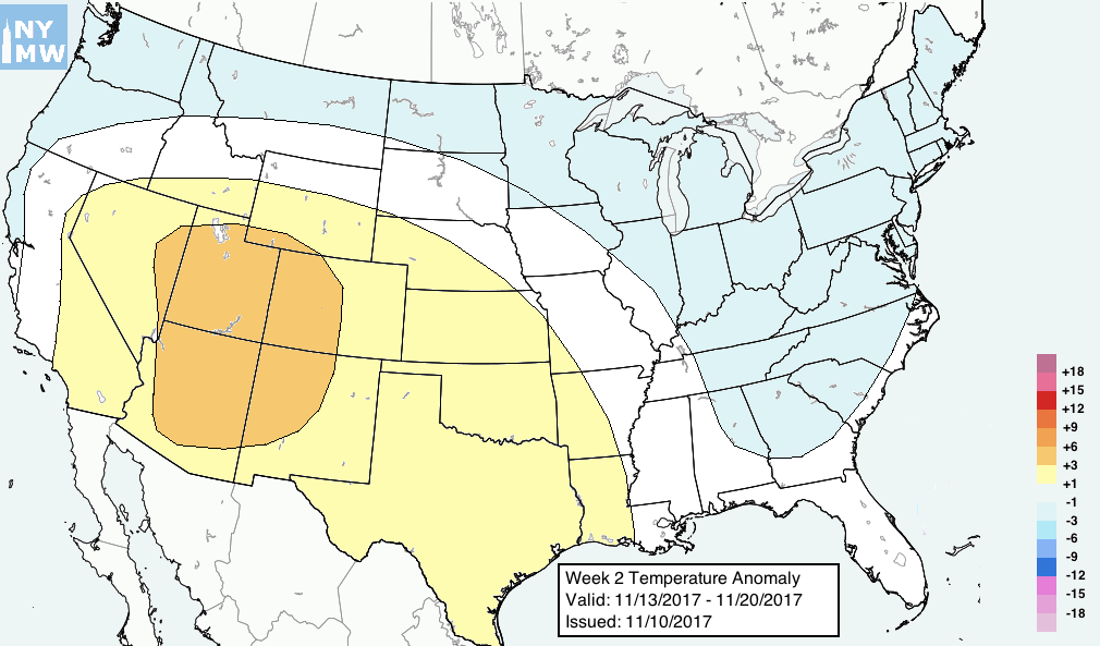
Increased amplitude of wave pattern across USA resulting in cooler anomalies over N Plains and Northeast. HDD net change upward in East.
This period features a deep analysis of tropical forcing, stratospheric and hemispheric conditions and a departure from forecast models which we had used over previous days. The feeling internally here is that the amplitude of the height pattern over the United States will increase during this period and forecast model guidance is still adjusting to this.
The ECMWF EPS signals a retrograde of the large ridge near Alaska. This is a huge red flag meteorologically as it often signals the beginning of a major pattern shift. The ridge anomaly near Alaska retrogrades ~1000 miles westward by Day 14. Additional ridging builds northward towards the Polar regions and forecast models continue to suggest high latitude blocking building into Greenland on the Atlantic Side.
There are several analogous years to 2017 in the tropical forcing/SSTA dataset. All of them featured similar responses and retrogrades of the pattern in Late Nov/Early Dec with high latitude blocking episodes. As a result, have adjusted the outlook to account for this. The result of these hemispheric changes will be cooler anomalies developing over the Northeast and possibly across the entire Northern ⅓ and Eastern ⅓ of the USA. Future outlooks will refine and tweak this forecast.
Week 3
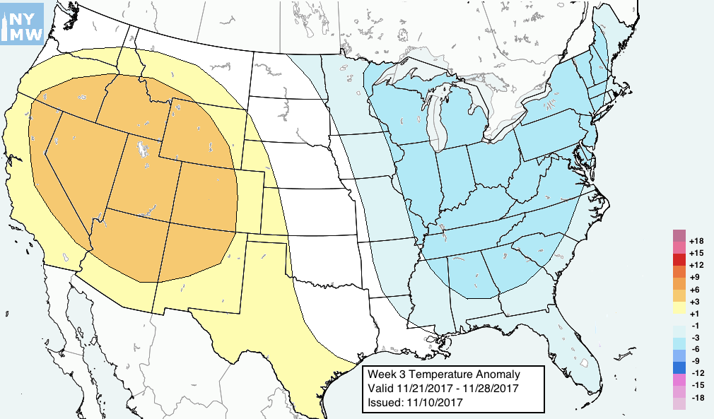
This period features some of the more significant changes of this outlook cycle. The majority of this forecast is based around forecasting principles and meteorological evolution and not forecast models. Therefore, we feel it is prudent to lay out our reasoning for the expected evolution which goes against the grain of the stagnant pattern which had been in place. The reasoning is as follows:
- ECMWF EPS and GEFS signaling the westward retrograde of a large positive ridge anomaly from 150 W to near 160 E, a westward retrograde of over 1000 miles. This will lead to wholesales changes in the pattern throughout the North Pacific Ocean.
- High latitude ridging building northward from Alaska towards the Polar Regions of British Columbia and North/Western Canada. This will help dislodge cold further south into the United States’ Western side.
- The development of above normal heights from Greenland to the Davis Strait in 10-15 days time. The biggest uncertainty in the forecast, will help to push cold air into the Great Lakes, Southern Canada, and the USA’s Northern ⅓ and Northeastern ¼.
- Analog years which matched the global dataset conditions from Oct-Nov 2017, rolled forward linearly support development of high latitude blocking and increased pattern amplitude.
As a result of all of this, we have opted to increase the amplitude of the forecast wave height pattern across the entire CONUS during this period. The resulting wave pattern results in a good low level cold air source from the N Plains into the Great Lakes and Northeast. While the exact intensity of the cold remains in extreme uncertainty, confidence is currently high enough to signal temperatures at or below normal for this time frame. Future shifts will refine.


