-2")
Premium Blogroll
Forecast Discussions
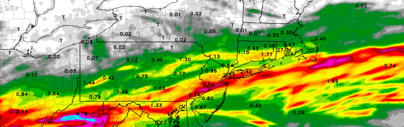
Major rains possible through Tuesday, may impact fireworks
A well advertised frontal boundary, and associated low pressure system, are forecast to move toward the area from Monday Night into Tuesday — and it may impact fireworks displays. While forecast models have fluctuated a bit with the exact placement of the storm system, the overall signal for heavy rainfall potential has been quite strong. […]
Premium: More heat, storm chances on the horizon
The atmospheric pattern so far, for the majority of Spring and now into the first week or two of calendar summer, has been a bit of an enigma. There have been transient bouts of warmth, with showers and thunderstorms, but cooler periods have followed. For the most part, our area has avoided widespread or organized […]
Tuesday Overview: More showers & t-storms later this afternoon
Unsettled weather continues this afternoon, with a cold front and upper-level trough slowly approaching the region. Skies clearing to the west will cause instability to increase enough for showers and thunderstorms to develop over Central and Eastern Pennsylvania later this afternoon by early this evening. These thunderstorms will gradually move into western parts of New […]
Local Observations


