As part of our winter forecasting feature this autumn, we’re releasing a few posts with information and tounge-in-cheek opinions about winter and meteorology. The first in the set comes this afternoon, where our forecasters sat down to compile a list of the 5 biggest forecast model myths as we head into winter. You can check them out below, to get a quick primer on what to expect over the next several months.
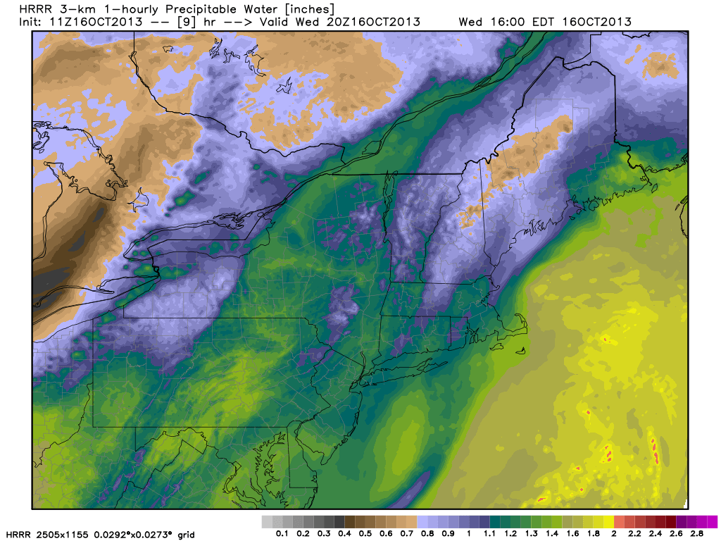
The combination of a weak coastal system, meandering off the Mid Atlantic coast, and multiple mid level disturbances moving through the Northeast US will result in generally unpleasant weather from Wednesday through the end of the week. The coastal system is weak but brings moisture and an onshore flow, as the decaying mid level vorticity slowly retrogrades towards the coast on Wednesday. Low clouds and drizzle are possible, despite the lack of any steady rain, especially near the coasts.
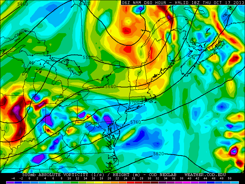
Mid level disturbances shifting northeast from the Mississippi and Ohio Valleys through the Great Lakes and Northeast will bring more unsettled weather through the end of the week — signaling the beginnings of a more active pattern. The weekend is expected to feature improving conditions once the frontal system eventually moves off the coast.
High resolution models showing increasing Precipitable Water values by later Wednesday evening.
https://www.nymetroweather.com/wp-content/uploads/2024/02/Empire-2000-x-300-px-2.png00John Homenukhttps://www.nymetroweather.com/wp-content/uploads/2024/02/Empire-2000-x-300-px-2.pngJohn Homenuk2013-10-16 07:47:312013-10-16 09:11:03Cloudy, drizzly and unsettled through weeks end
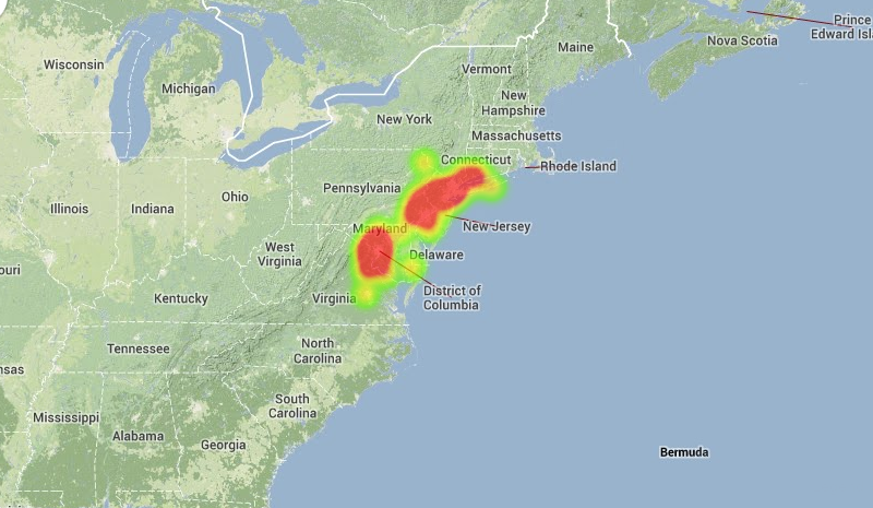
Widespread reports of a fireball, seen streaking through the sky last night around 830pm, continue to funnel in this afternoon. The American Meteor Society says they have recieved 71 official sighting reports of the meteor. Based on those details, they have concluded that the meteor entered the skies over New Jersey at 8:25pm, moving north-northwestward and eventually landing somewhere in Lancaster County, Pennsylvania. The data remains preliminary and the investigation into the event continues. The heat map, pictured below, shows the frequency of reported meteor sightings throughout the Northeast US.
Heat map of reported meteor sightings from October 14, 2013. Courtesy American Meteor Society.
https://www.nymetroweather.com/wp-content/uploads/2024/02/Empire-2000-x-300-px-2.png00John Homenukhttps://www.nymetroweather.com/wp-content/uploads/2024/02/Empire-2000-x-300-px-2.pngJohn Homenuk2013-10-15 15:24:282013-10-15 18:10:44Fireball reported, ISON and Orionid updates
Despite the fact that pleasant weather has essentially dominated late summer and Autumn thus far, the pattern of late has trended a bit more unsettled. This is fairly typical for this time of year, as the first signs of wavelength changes are beginning to be seen in the atmospheric pattern and jet stream. However, a more dramatic pattern change is being forecast by most models in the medium range — with noticeable wave amplification throughout the Northern Hemisphere. In the short term, unsettled weather will begin to impact the area as early as Wednesday with a weak system meandering offshore beginning to back towards a coast slightly. Another frontal system back to our west will eventually approach and cross the area around mid-week, bringing in the first of several shots of cooler air.
NAM model showing multiple disturbances in the mid levels (500mb) of the atmosphere later this week.
Hi friends! Our website uses cookies to provide an optimal browsing experience for you. New "Cookie Consent" laws mandate us to inform you of this. As long as you're cool with it, just hit OK. You'll only see this message once.
We may request cookies to be set on your device. We use cookies to let us know when you visit our websites, how you interact with us, to enrich your user experience, and to customize your relationship with our website.
Click on the different category headings to find out more. You can also change some of your preferences. Note that blocking some types of cookies may impact your experience on our websites and the services we are able to offer.
Essential Website Cookies
These cookies are strictly necessary to provide you with services available through our website and to use some of its features.
Because these cookies are strictly necessary to deliver the website, refusing them will have impact how our site functions. You always can block or delete cookies by changing your browser settings and force blocking all cookies on this website. But this will always prompt you to accept/refuse cookies when revisiting our site.
We fully respect if you want to refuse cookies but to avoid asking you again and again kindly allow us to store a cookie for that. You are free to opt out any time or opt in for other cookies to get a better experience. If you refuse cookies we will remove all set cookies in our domain.
We provide you with a list of stored cookies on your computer in our domain so you can check what we stored. Due to security reasons we are not able to show or modify cookies from other domains. You can check these in your browser security settings.
Other external services
We also use different external services like Google Webfonts, Google Maps, and external Video providers. Since these providers may collect personal data like your IP address we allow you to block them here. Please be aware that this might heavily reduce the functionality and appearance of our site. Changes will take effect once you reload the page.
-2")