-2")

Could it actually snow in NYC next week?
Forecast model data suggests that a coastal storm will pass south of the area on Tuesday, with cold air pushing in during the storm and leading to the potential for winter weather. Inconsistencies on model guidance with the track and intensity of the storm are leading to an unusually low confidence forecast.
After all of this time, and with temperatures in the lower 50s this afternoon, it may seem surprising that we’re discussing a winter storm threat now. The airmass in place across the area today is quite warm, but the pattern is changing around us and colder air will begin to press towards the area this weekend. The coldest air will still be well north of the area in Canada and New England, but there’s just enough present for us to pay attention.

Forecast guidance is keying in on a disturbance developing through the Mississippi River Valley early next week, eventually tracking northeastward towards the region. This disturbance will lead to the development of a surface low pressure along the Mid-Atlantic coast by late Monday and Tuesday. Lift and moisture from this system will bring precipitation into the area by Tuesday.
Initially, the airmass is still somewhat stale. It isn’t necessarily warmer or colder than normal, just stale. The storm approaching our area is being driven by a process called warm air advection, which is exactly what it sounds like – the advection of warm air. This leads to concerns for mixed precipitation or rain with the initial sequence of the storm system on Tuesday.
As time goes on Tuesday and Tuesday evening, guidance suggests the low pressure to our south will strengthen. This will start to pull colder air into the system from the north via the opposite process – cold air advection. As a result, there is the potential for mixed precipitation to change to accumulating snowfall as the system moves past the area on Tuesday night.
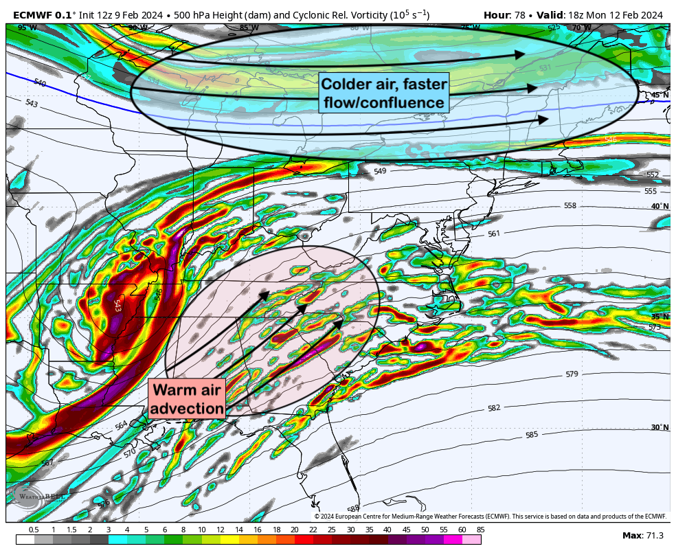
How much cold air comes into play will depend heavily on the strength of faster, confluent air flow to our north over Canada. This helps to suppress the storm south of us and pushes colder air into the area faster, leading to a more rapid change from mixed precipitation or rain to snow.
As you can imagine, the timing and intricacies of the system will determine just how this plays out in our area. Everything is still on the table – from mostly rain to a mixed precipitation event or even mostly snow. A middle ground scenario would favor rain and mixed precipitation changing to a light accumulating snowfall on the back end of the storm.
For now, our expectations are that we’ll see a wintry mixed precipitation event transitioning to snow at some point. When that transition occurs will determine if we see accumulating snow and how much. Interior and higher elevation areas have a better chance of seeing accumulating snow than the city.
Updates will continue from tonight into the weekend as confidence begins to increase on the intricacies of the storm.
Have a great Friday evening!
You have mentioned very interesting details! ps decent internet site. “Mediocrity knows nothing higher than itself, but talent instantly recognizes genius.” by Conan Doyle.
I do not even know the way I stopped up right here, but I believed this put up used to be good. I do not understand who you might be however definitely you are going to a well-known blogger when you aren’t already 😉 Cheers!
Simply a smiling visitant here to share the love (:, btw outstanding pattern.
Thankyou for this grand post, I am glad I noticed this site on yahoo.
Usually I do not learn post on blogs, however I would like to say that this write-up very compelled me to try and do so! Your writing taste has been amazed me. Thanks, quite great article.
Write more, thats all I have to say. Literally, it seems as though you relied on the video to make your point. You definitely know what youre talking about, why throw away your intelligence on just posting videos to your site when you could be giving us something enlightening to read?
I got good info from your blog
Thank you for another informative web site. Where else could I get that type of info written in such an ideal way? I’ve a project that I’m just now working on, and I have been on the look out for such info.
I have been examinating out many of your stories and it’s nice stuff. I will surely bookmark your website.
WONDERFUL Post.thanks for share..more wait .. …
Hey there, You have done a great job. I will certainly digg it and personally suggest to my friends. I am confident they will be benefited from this website.
When I originally commented I clicked the “Notify me when new comments are added” checkbox and now each time a comment is added I get several e-mails with the same comment. Is there any way you can remove me from that service? Cheers!
It’s really a nice and useful piece of info. I am happy that you simply shared this helpful info with us. Please keep us up to date like this. Thank you for sharing.
Hey there, You have done an excellent job. I will certainly digg it and personally recommend to my friends. I am confident they’ll be benefited from this website.
The core of your writing while sounding agreeable originally, did not really sit well with me personally after some time. Somewhere throughout the paragraphs you were able to make me a believer unfortunately only for a while. I nevertheless have got a problem with your jumps in logic and you might do well to help fill in those breaks. In the event you can accomplish that, I will surely end up being impressed.
Nice read, I just passed this onto a friend who was doing some research on that. And he actually bought me lunch since I found it for him smile Therefore let me rephrase that: Thank you for lunch! “Without friends no one would choose to live, though he had all other goods.” by Aristotle.
You actually make it seem really easy along with your presentation but I find this topic to be actually one thing that I feel I would by no means understand. It seems too complicated and very extensive for me. I’m taking a look ahead on your subsequent submit, I will try to get the dangle of it!
Hey would you mind sharing which blog platform you’re working with? I’m going to start my own blog soon but I’m having a hard time making a decision between BlogEngine/Wordpress/B2evolution and Drupal. The reason I ask is because your layout seems different then most blogs and I’m looking for something unique. P.S My apologies for being off-topic but I had to ask!
I have been browsing online more than three hours today, yet I by no means discovered any interesting article like yours. It’s pretty value sufficient for me. Personally, if all webmasters and bloggers made excellent content material as you did, the net shall be a lot more useful than ever before.
Good blog! I truly love how it is simple on my eyes and the data are well written. I’m wondering how I might be notified when a new post has been made. I have subscribed to your RSS feed which must do the trick! Have a nice day!
I am happy that I noticed this weblog, just the right information that I was searching for! .
It’s a shame you don’t have a donate button! I’d without a doubt donate to this brilliant blog! I suppose for now i’ll settle for book-marking and adding your RSS feed to my Google account. I look forward to brand new updates and will share this site with my Facebook group. Talk soon!
This is the right blog for anyone who wants to find out about this topic. You realize so much its almost hard to argue with you (not that I actually would want…HaHa). You definitely put a new spin on a topic thats been written about for years. Great stuff, just great!
I together with my pals ended up reviewing the good solutions found on your web site and the sudden I had a terrible suspicion I never thanked the web site owner for them. Most of the guys ended up happy to see them and have now actually been tapping into these things. Many thanks for being considerably helpful as well as for picking this kind of ideal themes millions of individuals are really eager to discover. My personal honest apologies for not expressing appreciation to earlier.
great post.Ne’er knew this, thanks for letting me know.
Saved as a favorite, I really like your blog!
I regard something genuinely interesting about your web blog so I saved to favorites.
he blog was how do i say it… relevant, finally something that helped me. Thanks
As soon as I discovered this website I went on reddit to share some of the love with them.
My spouse and I absolutely love your blog and find the majority of your post’s to be just what I’m looking for. Does one offer guest writers to write content available for you? I wouldn’t mind publishing a post or elaborating on a few of the subjects you write related to here. Again, awesome web log!
Aw, this was a very nice post. In concept I want to put in writing like this additionally – taking time and precise effort to make an excellent article… but what can I say… I procrastinate alot and under no circumstances appear to get one thing done.
This design is spectacular! You certainly know how to keep a reader entertained. Between your wit and your videos, I was almost moved to start my own blog (well, almost…HaHa!) Wonderful job. I really loved what you had to say, and more than that, how you presented it. Too cool!
Thank you for sharing excellent informations. Your web-site is so cool. I’m impressed by the details that you have on this site. It reveals how nicely you perceive this subject. Bookmarked this website page, will come back for extra articles. You, my friend, ROCK! I found simply the information I already searched all over the place and just could not come across. What a great site.
I went over this internet site and I think you have a lot of wonderful info , saved to fav (:.
you are really a good webmaster. The website loading speed is incredible. It seems that you’re doing any unique trick. In addition, The contents are masterpiece. you’ve done a excellent job on this topic!
Real excellent info can be found on web site. “Many complain of their memory, few of their judgment.” by Benjamin Franklin.
I went over this site and I think you have a lot of great info, bookmarked (:.
I’ll immediately grab your rss as I can not find your e-mail subscription link or newsletter service. Do you have any? Please let me know so that I could subscribe. Thanks.
I haven’t checked in here for some time because I thought it was getting boring, but the last few posts are great quality so I guess I will add you back to my everyday bloglist. You deserve it my friend 🙂
I was studying some of your articles on this website and I think this internet site is really instructive! Keep on posting.
I beloved up to you’ll receive performed proper here. The cartoon is tasteful, your authored subject matter stylish. nonetheless, you command get got an edginess over that you want be turning in the following. in poor health surely come more before once more since exactly the similar nearly a lot continuously inside case you shield this increase.
I think this internet site holds some real superb info for everyone :D.
I have been exploring for a bit for any high-quality articles or weblog posts on this sort of house . Exploring in Yahoo I ultimately stumbled upon this web site. Reading this info So i’m satisfied to convey that I have a very excellent uncanny feeling I discovered just what I needed. I such a lot undoubtedly will make sure to do not fail to remember this website and give it a glance regularly.
I’m still learning from you, as I’m improving myself. I absolutely enjoy reading all that is posted on your blog.Keep the posts coming. I liked it!
I’ve been browsing online greater than 3 hours today, yet I by no means discovered any attention-grabbing article like yours. It is pretty value sufficient for me. In my opinion, if all webmasters and bloggers made excellent content material as you probably did, the net will be a lot more useful than ever before.
I simply couldn’t go away your website prior to suggesting that I actually enjoyed the usual info a person provide in your guests? Is gonna be again frequently in order to check up on new posts
I enjoy your writing style genuinely enjoying this web site.
Does your website have a contact page? I’m having trouble locating it but, I’d like to shoot you an email. I’ve got some recommendations for your blog you might be interested in hearing. Either way, great site and I look forward to seeing it grow over time.
I think you have observed some very interesting details, appreciate it for the post.
Thank you for helping out, superb information. “Nobody can be exactly like me. Sometimes even I have trouble doing it.” by Tallulah Bankhead.
Hi there! I could have sworn I’ve been to this site before but after reading through some of the post I realized it’s new to me. Anyhow, I’m definitely delighted I found it and I’ll be bookmarking and checking back often!
An impressive share, I just given this onto a colleague who was doing just a little analysis on this. And he in actual fact bought me breakfast as a result of I found it for him.. smile. So let me reword that: Thnx for the treat! But yeah Thnkx for spending the time to debate this, I feel strongly about it and love reading extra on this topic. If doable, as you turn out to be experience, would you mind updating your weblog with extra details? It’s extremely helpful for me. Large thumb up for this blog put up!
Excellent post. I was checking constantly this weblog and I am impressed! Extremely helpful info particularly the final section 🙂 I deal with such information a lot. I was looking for this certain info for a long time. Thank you and best of luck.
hey there and thank you for your info – I’ve definitely picked up something new from right here. I did however expertise a few technical issues using this site, as I experienced to reload the web site a lot of times previous to I could get it to load properly. I had been wondering if your hosting is OK? Not that I am complaining, but sluggish loading instances times will often affect your placement in google and could damage your high-quality score if ads and marketing with Adwords. Well I’m adding this RSS to my email and could look out for much more of your respective fascinating content. Ensure that you update this again soon..
I likewise believe so , perfectly indited post! .
Have you ever thought about publishing an e-book or guest authoring on other websites? I have a blog centered on the same information you discuss and would really like to have you share some stories/information. I know my viewers would value your work. If you are even remotely interested, feel free to send me an email.
Thanks on your marvelous posting! I genuinely enjoyed reading it, you can be a great author.I will always bookmark your blog and definitely will come back very soon. I want to encourage continue your great writing, have a nice weekend!
In this awesome pattern of things you’ll receive an A+ for hard work. Where exactly you misplaced me was first in all the specifics. As it is said, details make or break the argument.. And it could not be much more true right here. Having said that, let me inform you just what exactly did deliver the results. The text is very persuasive and this is probably why I am taking the effort to opine. I do not make it a regular habit of doing that. Secondly, despite the fact that I can see the leaps in reasoning you make, I am not really confident of exactly how you seem to connect your points which make the actual conclusion. For the moment I will subscribe to your point but hope in the future you actually link the dots better.
You really make it seem so easy with your presentation but I find this topic to be really something which I think I would never understand. It seems too complex and very broad for me. I’m looking forward for your next post, I will try to get the hang of it!
I’m so happy to read this. This is the kind of manual that needs to be given and not the random misinformation that’s at the other blogs. Appreciate your sharing this best doc.
Hey there I am so excited I found your site, I really found you by mistake, while I was researching on Google for something else, Nonetheless I am here now and would just like to say thanks a lot for a incredible post and a all round exciting blog (I also love the theme/design), I don’t have time to browse it all at the moment but I have saved it and also added your RSS feeds, so when I have time I will be back to read more, Please do keep up the great work.
Hi, I think your site might be having browser compatibility issues. When I look at your website in Safari, it looks fine but when opening in Internet Explorer, it has some overlapping. I just wanted to give you a quick heads up! Other then that, fantastic blog!
Enjoyed looking at this, very good stuff, regards. “Curiosity killed the cat, but for a while I was a suspect.” by Steven Wright.
I am so happy to read this. This is the type of manual that needs to be given and not the accidental misinformation that’s at the other blogs. Appreciate your sharing this greatest doc.
Wow! Thank you! I always wanted to write on my blog something like that. Can I take a part of your post to my website?
I am perpetually thought about this, regards for putting up.
Admiring the hard work you put into your blog and in depth information you provide. It’s nice to come across a blog every once in a while that isn’t the same unwanted rehashed material. Wonderful read! I’ve bookmarked your site and I’m adding your RSS feeds to my Google account.
I like what you guys are up also. Such clever work and reporting! Carry on the superb works guys I’ve incorporated you guys to my blogroll. I think it will improve the value of my web site :).
Some genuinely nice stuff on this site, I love it.
You have observed very interesting details! ps decent web site. “Do not quench your inspiration and your inmagination do not become the slave of your model.” by Vincent Van Gogh.
Hi there! This is my first visit to your blog! We are a team of volunteers and starting a new initiative in a community in the same niche. Your blog provided us valuable information to work on. You have done a wonderful job!
Hi there, I discovered your website via Google even as looking for a similar matter, your web site came up, it seems to be good. I’ve bookmarked it in my google bookmarks.
I adore meeting useful info, this post has got me even more info! .
Hi just wanted to give you a quick heads up and let you know a few of the images aren’t loading correctly. I’m not sure why but I think its a linking issue. I’ve tried it in two different internet browsers and both show the same outcome.
Some really interesting details you have written.Helped me a lot, just what I was looking for :D.
Thanks, I’ve just been searching for info approximately this subject for a long time and yours is the greatest I’ve came upon so far. However, what in regards to the bottom line? Are you certain concerning the source?
I will immediately seize your rss feed as I can’t find your e-mail subscription link or e-newsletter service. Do you’ve any? Kindly let me recognise so that I may just subscribe. Thanks.
Great site you have here but I was curious about if you knew of any message boards that cover the same topics discussed in this article? I’d really like to be a part of online community where I can get opinions from other experienced people that share the same interest. If you have any recommendations, please let me know. Thank you!
I’ve been absent for some time, but now I remember why I used to love this blog. Thanks, I will try and check back more frequently. How frequently you update your site?
This blog is definitely rather handy since I’m at the moment creating an internet floral website – although I am only starting out therefore it’s really fairly small, nothing like this site. Can link to a few of the posts here as they are quite. Thanks much. Zoey Olsen
Some really interesting info , well written and broadly user pleasant.
Whats up very cool blog!! Man .. Beautiful .. Wonderful .. I’ll bookmark your blog and take the feeds also…I am happy to find so many useful info here within the publish, we need develop more strategies in this regard, thanks for sharing.
I respect your piece of work, thankyou for all the interesting articles.
Enjoyed studying this, very good stuff, appreciate it.
I regard something truly interesting about your web site so I saved to favorites.
Hi , I do believe this is an excellent blog. I stumbled upon it on Yahoo , i will come back once again. Money and freedom is the best way to change, may you be rich and help other people.
When I initially commented I clicked the -Notify me when new comments are added- checkbox and now each time a remark is added I get 4 emails with the identical comment. Is there any manner you possibly can take away me from that service? Thanks!
Heya i am for the first time here. I came across this board and I in finding It truly useful & it helped me out much. I’m hoping to provide one thing back and aid others like you aided me.
Woh I like your posts, saved to fav! .
he blog was how do i say it… relevant, finally something that helped me. Thanks
I am extremely inspired with your writing skills as well as with the format on your blog. Is that this a paid subject matter or did you modify it your self? Anyway keep up the excellent high quality writing, it is uncommon to peer a great blog like this one nowadays..
Thanks a lot for sharing this with all of us you really know what you’re talking about! Bookmarked. Please also visit my website =). We could have a link exchange arrangement between us!
Very interesting info !Perfect just what I was looking for!
Perfectly pent subject material, Really enjoyed looking at.
I think this site has very good written written content blog posts.
With havin so much content do you ever run into any problems of plagorism or copyright infringement? My website has a lot of exclusive content I’ve either written myself or outsourced but it seems a lot of it is popping it up all over the web without my authorization. Do you know any methods to help protect against content from being stolen? I’d really appreciate it.
There is apparently a bunch to identify about this. I assume you made certain nice points in features also.
I got good info from your blog
Im now not certain the place you are getting your information, however good topic. I must spend a while studying more or working out more. Thanks for great information I was looking for this information for my mission.
Hi, i believe that i saw you visited my weblog thus i got here to “go back the want”.I am attempting to to find issues to enhance my web site!I suppose its ok to use some of your concepts!!
Hola! I’ve been reading your site for a while now and finally got the courage to go ahead and give you a shout out from Humble Texas! Just wanted to mention keep up the fantastic job!
I always was interested in this subject and stock still am, appreciate it for posting.
Thanks for one’s marvelous posting! I truly enjoyed reading it, you are a great author.I will be sure to bookmark your blog and will eventually come back down the road. I want to encourage yourself to continue your great work, have a nice holiday weekend!
Some really good information, Glad I detected this.
Today, I went to the beach with my kids. I found a sea shell and gave it to my 4 year old daughter and said “You can hear the ocean if you put this to your ear.” She placed the shell to her ear and screamed. There was a hermit crab inside and it pinched her ear. She never wants to go back! LoL I know this is completely off topic but I had to tell someone!
This is a very good tips especially to those new to blogosphere, brief and accurate information… Thanks for sharing this one. A must read article.
I am glad to be one of several visitors on this great website (:, regards for putting up.
An impressive share, I simply given this onto a colleague who was doing somewhat evaluation on this. And he in actual fact purchased me breakfast because I found it for him.. smile. So let me reword that: Thnx for the deal with! But yeah Thnkx for spending the time to debate this, I feel strongly about it and love reading extra on this topic. If potential, as you grow to be experience, would you thoughts updating your weblog with more particulars? It’s extremely helpful for me. Large thumb up for this weblog publish!
Would you be eager about exchanging links?
Some genuinely wonderful info , Glad I noticed this. “Be true to your work, your word, and your friend.” by Henry David Thoreau.
This design is steller! You certainly know how to keep a reader entertained. Between your wit and your videos, I was almost moved to start my own blog (well, almost…HaHa!) Great job. I really loved what you had to say, and more than that, how you presented it. Too cool!
I’m typically to running a blog and i really respect your content. The article has really peaks my interest. I’m going to bookmark your website and hold checking for brand new information.
I have read some just right stuff here. Definitely worth bookmarking for revisiting. I surprise how so much effort you place to make this kind of excellent informative web site.
Some genuinely superb blog posts on this web site, thank you for contribution. “A religious awakening which does not awaken the sleeper to love has roused him in vain.” by Jessamyn West.
At this time it seems like Expression Engine is the best blogging platform available right now. (from what I’ve read) Is that what you’re using on your blog?
What i do not understood is actually how you’re not actually much more well-liked than you might be now. You are so intelligent. You realize thus considerably relating to this subject, produced me personally consider it from a lot of varied angles. Its like men and women aren’t fascinated unless it’s one thing to accomplish with Lady gaga! Your own stuffs great. Always maintain it up!
Very interesting information!Perfect just what I was searching for! “Time is money.” by Benjamin Franklin.
Hey! I could have sworn I’ve been to this blog before but after checking through some of the post I realized it’s new to me. Anyhow, I’m definitely delighted I found it and I’ll be book-marking and checking back frequently!
You are my inhalation, I own few web logs and occasionally run out from to post .
I always was concerned in this subject and stock still am, appreciate it for posting.
Keep functioning ,remarkable job!
Wonderful work! This is the type of information that should be shared around the web. Shame on the search engines for not positioning this post higher! Come on over and visit my site . Thanks =)
Well I definitely enjoyed studying it. This information offered by you is very helpful for proper planning.
Hello there! I know this is kind of off topic but I was wondering if you knew where I could locate a captcha plugin for my comment form? I’m using the same blog platform as yours and I’m having difficulty finding one? Thanks a lot!
Howdy! This is kind of off topic but I need some advice from an established blog. Is it difficult to set up your own blog? I’m not very techincal but I can figure things out pretty quick. I’m thinking about creating my own but I’m not sure where to begin. Do you have any points or suggestions? With thanks
Hello, you used to write excellent, but the last few posts have been kinda boringK I miss your super writings. Past several posts are just a little bit out of track! come on!
Very interesting points you have observed, regards for putting up. “Custom is the great guide of human life.” by David Hume.
I am not sure where you’re getting your info, but good topic. I needs to spend a while studying much more or working out more. Thank you for great information I was searching for this info for my mission.
Having read this I thought it was very informative. I appreciate you taking the time and effort to put this article together. I once again find myself spending way to much time both reading and commenting. But so what, it was still worth it!
I have read a few just right stuff here. Definitely worth bookmarking for revisiting. I wonder how a lot effort you set to create one of these great informative web site.
My spouse and I stumbled over here from a different web page and thought I might check things out. I like what I see so now i’m following you. Look forward to going over your web page yet again.
급하게 현금이 필요한 순간, 소액결제 현금화를 안전하게 이용하는 방법을 안내합니다. 실제 이용 기준으로 수수료, 절차, 주의사항까지 빠르게 확인하세요.
I’ve recently started a site, the info you provide on this website has helped me greatly. Thank you for all of your time & work.
I have learn a few good stuff here. Definitely value bookmarking for revisiting. I surprise how a lot effort you put to make any such great informative web site.
I know this if off topic but I’m looking into starting my own weblog and was wondering what all is required to get setup? I’m assuming having a blog like yours would cost a pretty penny? I’m not very web savvy so I’m not 100 certain. Any recommendations or advice would be greatly appreciated. Many thanks
I’ve been exploring for a bit for any high-quality articles or weblog posts on this kind of area . Exploring in Yahoo I finally stumbled upon this site. Reading this information So i am satisfied to show that I’ve a very excellent uncanny feeling I discovered exactly what I needed. I so much unquestionably will make certain to do not fail to remember this website and give it a glance on a continuing basis.
Just wanna comment on few general things, The website design and style is perfect, the subject material is real fantastic : D.
hi!,I like your writing very much! share we keep in touch more approximately your post on AOL? I need a specialist in this house to unravel my problem. May be that is you! Taking a look forward to peer you.
Way cool, some valid points! I appreciate you making this article available, the rest of the site is also high quality. Have a fun.
hi!,I like your writing very much! share we communicate more about your article on AOL? I need a specialist on this area to solve my problem. May be that’s you! Looking forward to see you.
Its excellent as your other posts : D, regards for posting. “Say not, ‘I have found the truth,’ but rather, ‘I have found a truth.'” by Kahlil Gibran.
you are in reality a excellent webmaster. The website loading pace is incredible. It kind of feels that you are doing any unique trick. In addition, The contents are masterwork. you have performed a great activity in this matter!
fiz2j8
Hello, Neat post. There’s an issue with your site in web explorer, would check this?K IE still is the marketplace leader and a huge section of other folks will pass over your magnificent writing due to this problem.
Yeah bookmaking this wasn’t a high risk determination outstanding post! .
This is really interesting, You’re an overly professional blogger. I have joined your feed and look forward to in search of more of your excellent post. Additionally, I have shared your web site in my social networks!
I’m extremely impressed along with your writing skills and also with the layout to your blog. Is this a paid theme or did you modify it your self? Anyway keep up the nice high quality writing, it is rare to see a great blog like this one today..
Do you mind if I quote a few of your articles as long as I provide credit and sources back to your website? My website is in the exact same area of interest as yours and my visitors would truly benefit from some of the information you provide here. Please let me know if this okay with you. Thanks a lot!
I have been surfing on-line greater than 3 hours lately, yet I by no means discovered any interesting article like yours. It is lovely price enough for me. Personally, if all website owners and bloggers made excellent content as you did, the web shall be a lot more useful than ever before. “I thank God for my handicaps, for through them, I have found myself, my work and my God.” by Hellen Keller.
I truly appreciate this post. I have been looking all over for this! Thank goodness I found it on Bing. You have made my day! Thx again!
I conceive you have mentioned some very interesting details , appreciate it for the post.
Thanks for this terrific post, I am glad I discovered this web site on yahoo.
Dead indited content material, appreciate it for selective information. “The last time I saw him he was walking down Lover’s Lane holding his own hand.” by Fred Allen.
Howdy! This post couldn’t be written any better! Reading this post reminds me of my previous room mate! He always kept chatting about this. I will forward this write-up to him. Fairly certain he will have a good read. Thank you for sharing!
Im now not certain the place you’re getting your information, but great topic. I needs to spend a while studying much more or working out more. Thanks for excellent information I was searching for this information for my mission.
As a Newbie, I am always browsing online for articles that can be of assistance to me. Thank you
I couldn’t resist commenting
I was recommended this website via my cousin. I’m no longer sure whether this publish is written by means of him as nobody else recognise such unique approximately my difficulty. You are amazing! Thanks!
I’d have to examine with you here. Which is not one thing I usually do! I take pleasure in reading a post that may make folks think. Additionally, thanks for permitting me to comment!
We are a group of volunteers and starting a new scheme in our community. Your site provided us with useful info to work on. You have performed a formidable task and our whole community might be thankful to you.
Wow, wonderful blog layout! How long have you been blogging for? you make blogging look easy. The overall look of your website is fantastic, as well as the content!
Hello There. I found your blog using msn. This is a very well written article. I’ll make sure to bookmark it and return to read more of your useful information. Thanks for the post. I’ll definitely comeback.
Dead indited content material, regards for information .
Deference to author, some good entropy.
You really make it seem really easy together with your presentation but I in finding this topic to be actually one thing that I feel I’d never understand. It sort of feels too complex and very large for me. I am looking ahead for your subsequent publish, I’ll try to get the hang of it!
Hey there I am so excited I found your web site, I really found you by mistake, while I was looking on Yahoo for something else, Anyhow I am here now and would just like to say thanks a lot for a incredible post and a all round enjoyable blog (I also love the theme/design), I don’t have time to read it all at the moment but I have saved it and also included your RSS feeds, so when I have time I will be back to read much more, Please do keep up the great job.
I conceive this web site has got some very wonderful info for everyone :D. “Experience is not what happens to you it’s what you do with what happens to you.” by Aldous Huxley.
I rattling lucky to find this internet site on bing, just what I was searching for : D also saved to favorites.
You are my inspiration, I possess few web logs and often run out from brand :). “Fiat justitia et pereat mundus.Let justice be done, though the world perish.” by Ferdinand I.
Everything is very open and very clear explanation of issues. was truly information. Your website is very useful. Thanks for sharing.
Your place is valueble for me. Thanks!…
I really enjoy reading through on this internet site, it holds excellent content. “Those who complain most are most to be complained of.” by Matthew Henry.
Outstanding post, I believe website owners should acquire a lot from this blog its really user pleasant.
Thanks for another informative blog. Where else could I get that type of info written in such a perfect way? I’ve a project that I’m just now working on, and I have been on the look out for such information.
Very interesting topic, thanks for posting.
It’s in reality a nice and helpful piece of info. I am satisfied that you just shared this useful information with us. Please keep us informed like this. Thank you for sharing.
I haven’t checked in here for a while because I thought it was getting boring, but the last few posts are good quality so I guess I’ll add you back to my everyday bloglist. You deserve it my friend 🙂
Howdy just wanted to give you a quick heads up. The words in your content seem to be running off the screen in Internet explorer. I’m not sure if this is a formatting issue or something to do with browser compatibility but I figured I’d post to let you know. The design look great though! Hope you get the problem resolved soon. Many thanks
I would like to thnkx for the efforts you have put in writing this blog. I am hoping the same high-grade blog post from you in the upcoming as well. In fact your creative writing abilities has inspired me to get my own blog now. Really the blogging is spreading its wings quickly. Your write up is a good example of it.
It’s really a nice and useful piece of info. I’m glad that you shared this helpful information with us. Please keep us informed like this. Thank you for sharing.
I was examining some of your blog posts on this internet site and I believe this internet site is real instructive! Keep posting.
Hi my friend! I want to say that this article is amazing, nice written and include almost all vital infos. I would like to see more posts like this.
Wohh precisely what I was looking for, appreciate it for posting.
I have been exploring for a little bit for any high-quality articles or blog posts on this kind of house . Exploring in Yahoo I at last stumbled upon this site. Studying this information So i am glad to exhibit that I’ve a very excellent uncanny feeling I discovered just what I needed. I so much definitely will make certain to don’t forget this site and provides it a glance regularly.
I am commenting to let you be aware of what a fine discovery my wife’s girl undergone using your site. She discovered such a lot of pieces, most notably what it is like to possess an ideal giving heart to make other people without hassle comprehend several advanced things. You really surpassed her expected results. Many thanks for displaying the valuable, safe, explanatory and in addition cool thoughts on that topic to Ethel.
I have read a few good stuff here. Definitely value bookmarking for revisiting. I surprise how a lot attempt you place to make any such fantastic informative site.
Have you ever thought about including a little bit more than just your articles? I mean, what you say is valuable and all. But imagine if you added some great pictures or videos to give your posts more, “pop”! Your content is excellent but with pics and clips, this website could certainly be one of the greatest in its field. Excellent blog!
Fantastic goods from you, man. I’ve understand your stuff previous to and you’re just extremely fantastic. I really like what you’ve acquired here, really like what you’re stating and the way in which you say it. You make it entertaining and you still care for to keep it sensible. I can’t wait to read much more from you. This is actually a terrific web site.
Hey! This is my 1st comment here so I just wanted to give a quick shout out and tell you I genuinely enjoy reading your blog posts. Can you recommend any other blogs/websites/forums that go over the same subjects? Many thanks!
I am glad to be a visitor of this stark web blog! , thankyou for this rare information! .
Howdy! This post could not be written any better! Reading through this post reminds me of my previous room mate! He always kept talking about this. I will forward this article to him. Fairly certain he will have a good read. Thank you for sharing!
Yeah bookmaking this wasn’t a speculative decision great post! .
Undeniably believe that which you said. Your favorite reason appeared to be on the web the simplest factor to take into accout of. I say to you, I certainly get irked whilst other people think about concerns that they just don’t know about. You managed to hit the nail upon the highest as smartly as outlined out the whole thing with no need side-effects , other folks could take a signal. Will probably be again to get more. Thanks
I like this site very much, Its a very nice berth to read and receive info .
Heya i am for the first time here. I came across this board and I find It truly useful & it helped me out much. I hope to give something back and help others like you helped me.
Woah! I’m really loving the template/theme of this site. It’s simple, yet effective. A lot of times it’s very hard to get that “perfect balance” between usability and appearance. I must say you have done a amazing job with this. In addition, the blog loads very quick for me on Opera. Excellent Blog!
I’m extremely inspired along with your writing abilities as neatly as with the layout in your blog. Is that this a paid theme or did you customize it yourself? Anyway keep up the nice quality writing, it’s uncommon to see a nice blog like this one these days..
I’ve recently started a website, the information you offer on this web site has helped me tremendously. Thanks for all of your time & work.
I will right away grab your rss feed as I can’t find your e-mail subscription link or newsletter service. Do you have any? Kindly allow me recognize so that I may just subscribe. Thanks.
Good day! Do you know if they make any plugins to assist with SEO? I’m trying to get my blog to rank for some targeted keywords but I’m not seeing very good success. If you know of any please share. Kudos!
Just desire to say your article is as amazing. The clarity to your publish is just cool and that i could suppose you’re knowledgeable on this subject. Fine along with your permission let me to take hold of your RSS feed to stay up to date with imminent post. Thank you 1,000,000 and please carry on the rewarding work.
I believe other website owners should take this website as an example , very clean and superb user pleasant layout.
Thanks for the sensible critique. Me and my neighbor were just preparing to do some research on this. We got a grab a book from our area library but I think I learned more clear from this post. I am very glad to see such magnificent info being shared freely out there.
I consider something really special in this internet site.
Appreciate it for all your efforts that you have put in this. very interesting information.
Hi! This is kind of off topic but I need some help from an established blog. Is it very difficult to set up your own blog? I’m not very techincal but I can figure things out pretty quick. I’m thinking about creating my own but I’m not sure where to start. Do you have any ideas or suggestions? Cheers
I visited a lot of website but I think this one holds something special in it in it
You have brought up a very fantastic points, thankyou for the post.
Some truly interesting points you have written.Aided me a lot, just what I was searching for :D.
I just couldn’t leave your site prior to suggesting that I extremely loved the usual info a person supply to your visitors? Is going to be back continuously to check out new posts.
I like this site very much, Its a really nice place to read and receive info .
I’ve learn some just right stuff here. Certainly value bookmarking for revisiting. I surprise how much attempt you place to create such a fantastic informative website.
Its like you read my mind! You appear to know so much about this, like you wrote the book in it or something. I think that you can do with a few pics to drive the message home a little bit, but instead of that, this is excellent blog. A great read. I’ll certainly be back.
I was very happy to find this web-site.I wished to thanks to your time for this wonderful read!! I definitely having fun with every little little bit of it and I have you bookmarked to take a look at new stuff you weblog post.
I truly appreciate this post. I’ve been looking everywhere for this! Thank goodness I found it on Bing. You’ve made my day! Thanks again!
I saw a lot of website but I think this one holds something extra in it in it
I wanted to thank you for this great read!! I definitely enjoying every little bit of it I have you bookmarked to check out new stuff you post…
Whats up very nice web site!! Guy .. Beautiful .. Wonderful .. I’ll bookmark your web site and take the feeds additionally…I’m satisfied to seek out a lot of useful information right here within the post, we want develop more strategies on this regard, thanks for sharing.
very good post, i actually love this website, keep on it
I’d incessantly want to be update on new articles on this website , saved to favorites! .
Some genuinely nice and utilitarian info on this site, too I think the style and design contains superb features.
Nice post. I be taught one thing more challenging on totally different blogs everyday. It is going to always be stimulating to read content from other writers and apply a bit one thing from their store. I’d prefer to make use of some with the content on my blog whether you don’t mind. Natually I’ll provide you with a link on your web blog. Thanks for sharing.
so much good info on here, :D.
Some truly grand work on behalf of the owner of this internet site, absolutely great content.
Does your blog have a contact page? I’m having problems locating it but, I’d like to send you an e-mail. I’ve got some recommendations for your blog you might be interested in hearing. Either way, great website and I look forward to seeing it expand over time.
Aw, this was a very nice post. In idea I wish to put in writing like this moreover – taking time and precise effort to make a very good article… but what can I say… I procrastinate alot and on no account seem to get something done.
I’m not that much of a internet reader to be honest but your blogs really nice, keep it up! I’ll go ahead and bookmark your website to come back down the road. All the best
This web site is really a walk-through for all of the info you wanted about this and didn’t know who to ask. Glimpse here, and you’ll definitely discover it.
you have a great blog here! would you like to make some invite posts on my blog?
Excellent site. Plenty of helpful information here. I am sending it to several pals ans also sharing in delicious. And obviously, thank you to your sweat!
I’m impressed, I must say. Actually not often do I encounter a weblog that’s both educative and entertaining, and let me inform you, you will have hit the nail on the head. Your thought is excellent; the issue is one thing that not sufficient persons are talking intelligently about. I’m very comfortable that I stumbled across this in my seek for something relating to this.
Nice post. I was checking continuously this weblog and I am impressed! Very useful info specially the final part 🙂 I maintain such info much. I used to be seeking this certain information for a long time. Thanks and best of luck.
I haven’t checked in here for a while as I thought it was getting boring, but the last few posts are good quality so I guess I’ll add you back to my daily bloglist. You deserve it my friend 🙂
Woh I like your content, bookmarked! .
Hi there, I found your website by the use of Google even as looking for a comparable topic, your site got here up, it appears great. I’ve bookmarked it in my google bookmarks.
You are a very smart individual!
As I site possessor I believe the content material here is rattling magnificent , appreciate it for your efforts. You should keep it up forever! Good Luck.
Nice blog right here! Additionally your website lots up very fast! What web host are you using? Can I am getting your affiliate link in your host? I want my website loaded up as quickly as yours lol
You should take part in a contest for one of the best blogs on the web. I will recommend this site!
I was looking at some of your articles on this website and I believe this website is very informative! Keep putting up.
I like the efforts you have put in this, appreciate it for all the great posts.
What i don’t understood is in truth how you are now not really a lot more well-liked than you may be right now. You’re very intelligent. You know therefore significantly relating to this topic, produced me for my part consider it from a lot of varied angles. Its like men and women don’t seem to be fascinated until it is something to do with Girl gaga! Your personal stuffs nice. At all times maintain it up!
It is best to take part in a contest for among the best blogs on the web. I will recommend this site!
I simply wanted to thank you so much again. I’m not certain the things I could possibly have gone through in the absence of those creative concepts shown by you about that situation. Previously it was a real challenging concern in my circumstances, nevertheless taking a look at the very well-written manner you handled that forced me to jump for joy. I’m just thankful for this support and even believe you really know what an amazing job that you’re undertaking instructing the rest through the use of your webblog. I know that you haven’t encountered any of us.
I really enjoy examining on this site, it has fantastic posts.
You are my aspiration, I own few web logs and infrequently run out from post :). “Never mistake motion for action.” by Ernest Hemingway.
I wanted to thank you for this great read!! I definitely enjoying every little bit of it I have you bookmarked to check out new stuff you post…
Wow! This can be one particular of the most helpful blogs We’ve ever arrive across on this subject. Basically Excellent. I’m also an expert in this topic therefore I can understand your effort.
I like the valuable information you provide in your articles. I will bookmark your blog and check again here frequently. I am quite certain I will learn a lot of new stuff right here! Best of luck for the next!
Hello there, I found your website via Google while searching for a related topic, your web site came up, it looks great. I’ve bookmarked it in my google bookmarks.
I’m impressed, I must say. Really not often do I encounter a blog that’s each educative and entertaining, and let me tell you, you might have hit the nail on the head. Your thought is outstanding; the difficulty is something that not sufficient persons are talking intelligently about. I’m very happy that I stumbled across this in my search for one thing referring to this.
I’m curious to find out what blog system you’re working with? I’m experiencing some minor security problems with my latest blog and I would like to find something more risk-free. Do you have any recommendations?
you’ve gotten an important blog here! would you wish to make some invite posts on my blog?
hey there and thanks on your information – I have certainly picked up something new from proper here. I did alternatively expertise some technical points using this site, since I skilled to reload the site many times previous to I could get it to load correctly. I have been thinking about if your web hosting is OK? No longer that I’m complaining, however sluggish loading cases times will sometimes affect your placement in google and can damage your high-quality score if advertising and ***********|advertising|advertising|advertising and *********** with Adwords. Well I’m adding this RSS to my email and can glance out for much extra of your respective interesting content. Ensure that you replace this once more very soon..
Good day! I know this is kinda off topic but I’d figured I’d ask. Would you be interested in trading links or maybe guest writing a blog post or vice-versa? My website covers a lot of the same topics as yours and I think we could greatly benefit from each other. If you are interested feel free to shoot me an e-mail. I look forward to hearing from you! Awesome blog by the way!
I conceive you have remarked some very interesting details, regards for the post.
Hi there, just became aware of your blog through Google, and found that it is really informative. I am going to watch out for brussels. I will be grateful if you continue this in future. Many people will be benefited from your writing. Cheers!
It is actually a nice and helpful piece of info. I’m satisfied that you shared this useful information with us. Please keep us up to date like this. Thanks for sharing.
Wonderful blog! Do you have any hints for aspiring writers? I’m planning to start my own blog soon but I’m a little lost on everything. Would you recommend starting with a free platform like WordPress or go for a paid option? There are so many choices out there that I’m completely overwhelmed .. Any tips? Thanks!
It’s really a nice and helpful piece of information. I am happy that you shared this helpful information with us. Please stay us informed like this. Thank you for sharing.
I do not even understand how I stopped up right here, but I assumed this submit was once good. I do not understand who you might be however certainly you’re going to a famous blogger if you happen to are not already 😉 Cheers!
I view something genuinely special in this website .
I really enjoy reading through on this site, it contains good posts.
Magnificent website. A lot of useful information here. I am sending it to some friends ans also sharing in delicious. And certainly, thanks for your effort!
Hmm is anyone else encountering problems with the images on this blog loading? I’m trying to figure out if its a problem on my end or if it’s the blog. Any feed-back would be greatly appreciated.
You have remarked very interesting points! ps nice website .
Some really nice and useful info on this internet site, besides I think the style and design has excellent features.
Hey there, I think your blog might be having browser compatibility issues. When I look at your blog in Opera, it looks fine but when opening in Internet Explorer, it has some overlapping. I just wanted to give you a quick heads up! Other then that, excellent blog!
It is appropriate time to make some plans for the future and it is time to be happy. I’ve read this post and if I could I want to suggest you few interesting things or advice. Maybe you could write next articles referring to this article. I want to read even more things about it!
Some genuinely wonderful articles on this web site, appreciate it for contribution.
fantastic points altogether, you simply gained a emblem new reader. What may you suggest in regards to your post that you just made a few days in the past? Any sure?
I love it when people come together and share opinions, great blog, keep it up.
It’s really a great and useful piece of info. I am glad that you shared this useful info with us. Please stay us up to date like this. Thank you for sharing.
I’ve been browsing online more than three hours these days, but I by no means found any interesting article like yours. It is lovely price sufficient for me. In my opinion, if all website owners and bloggers made good content as you did, the net will likely be a lot more helpful than ever before.
Hi , I do believe this is an excellent blog. I stumbled upon it on Yahoo , i will come back once again. Money and freedom is the best way to change, may you be rich and help other people.
Some truly interesting info , well written and loosely user friendly.
Hello! I could have sworn I’ve been to this blog before but after browsing through some of the post I realized it’s new to me. Anyways, I’m definitely happy I found it and I’ll be book-marking and checking back frequently!
Do you have a spam problem on this website; I also am a blogger, and I was wondering your situation; many of us have created some nice practices and we are looking to swap techniques with others, please shoot me an email if interested.
Can I simply say what a reduction to find somebody who actually knows what theyre speaking about on the internet. You positively know easy methods to bring a problem to light and make it important. Extra individuals need to learn this and understand this facet of the story. I cant imagine youre no more common since you definitely have the gift.
I like this website so much, saved to favorites.
Today, I went to the beachfront with my children. I found a sea shell and gave it to my 4 year old daughter and said “You can hear the ocean if you put this to your ear.” She placed the shell to her ear and screamed. There was a hermit crab inside and it pinched her ear. She never wants to go back! LoL I know this is totally off topic but I had to tell someone!
Some really select articles on this internet site, bookmarked.
Just wanna say that this is very useful, Thanks for taking your time to write this.
I am continuously looking online for posts that can facilitate me. Thanks!
Hey just wanted to give you a quick heads up. The words in your content seem to be running off the screen in Safari. I’m not sure if this is a format issue or something to do with browser compatibility but I thought I’d post to let you know. The design and style look great though! Hope you get the problem fixed soon. Cheers
I love your blog.. very nice colors & theme. Did you create this website yourself? Plz reply back as I’m looking to create my own blog and would like to know wheere u got this from. thanks
obviously like your web-site however you need to check the spelling on several of your posts. Several of them are rife with spelling problems and I to find it very troublesome to tell the reality on the other hand I will surely come again again.
Normally I don’t learn article on blogs, but I wish to say that this write-up very compelled me to take a look at and do so! Your writing taste has been surprised me. Thank you, quite great article.
Having read this I thought it was very informative. I appreciate you taking the time and effort to put this article together. I once again find myself spending way to much time both reading and commenting. But so what, it was still worth it!
Heya! I just wanted to ask if you ever have any issues with hackers? My last blog (wordpress) was hacked and I ended up losing several weeks of hard work due to no backup. Do you have any methods to stop hackers?
you have a great blog here! would you like to make some invite posts on my blog?
I delight in, result in I discovered just what I used to be looking for. You’ve ended my 4 day lengthy hunt! God Bless you man. Have a nice day. Bye
Hiya very cool blog!! Guy .. Excellent .. Wonderful .. I will bookmark your blog and take the feeds also…I am satisfied to seek out a lot of useful information here in the publish, we need work out extra techniques on this regard, thank you for sharing. . . . . .
I have been browsing online greater than 3 hours today, yet I never found any fascinating article like yours. It’s pretty worth sufficient for me. In my opinion, if all webmasters and bloggers made good content material as you did, the web will likely be much more useful than ever before.
The very heart of your writing while appearing reasonable in the beginning, did not really sit well with me personally after some time. Someplace within the paragraphs you actually managed to make me a believer unfortunately only for a short while. I nevertheless have got a problem with your jumps in assumptions and you would do nicely to fill in all those breaks. If you can accomplish that, I could certainly end up being amazed.
Hello there! This is my first visit to your blog! We are a team of volunteers and starting a new project in a community in the same niche. Your blog provided us beneficial information to work on. You have done a wonderful job!
Good write-up, I am normal visitor of one’s blog, maintain up the excellent operate, and It’s going to be a regular visitor for a long time.
Howdy! Would you mind if I share your blog with my twitter group? There’s a lot of folks that I think would really appreciate your content. Please let me know. Thanks
so much superb info on here, :D.
Would you be concerned about exchanging links?
hello there and thanks to your information – I’ve definitely picked up anything new from right here. I did however experience several technical points using this site, since I skilled to reload the web site many times previous to I may get it to load correctly. I were considering in case your web host is OK? Not that I am complaining, however slow loading instances instances will sometimes have an effect on your placement in google and could injury your high-quality rating if ads and ***********|advertising|advertising|advertising and *********** with Adwords. Anyway I’m adding this RSS to my email and can glance out for much more of your respective fascinating content. Ensure that you replace this again soon..
Almost all of whatever you claim is astonishingly accurate and it makes me wonder why I hadn’t looked at this in this light before. This particular piece truly did turn the light on for me as far as this subject goes. Nonetheless at this time there is actually one point I am not too comfortable with so while I try to reconcile that with the actual main theme of the point, allow me observe just what the rest of your readers have to point out.Nicely done.
Wow! This can be one particular of the most helpful blogs We have ever arrive across on this subject. Actually Great. I’m also an expert in this topic therefore I can understand your effort.
Thanks , I have recently been searching for information about this subject for a while and yours is the best I’ve discovered till now. But, what concerning the bottom line? Are you positive in regards to the supply?
Hello.This post was really interesting, particularly because I was browsing for thoughts on this topic last Sunday.
Great post. I am facing a couple of these problems.
I think other website proprietors should take this internet site as an model, very clean and great user pleasant style and design.
Discover how SBLC and Bank Guarantee monetization works in trade finance, including liquidity access, structured funding, risk management, and global trade financing solutions.
Some genuinely fantastic information, Glad I found this.
Hello, you used to write excellent, but the last few posts have been kinda boring?K I miss your great writings. Past several posts are just a bit out of track! come on!
I’ve been exploring for a little for any high quality articles or blog posts on this sort of area . Exploring in Yahoo I at last stumbled upon this site. Reading this information So i am happy to convey that I’ve a very good uncanny feeling I discovered just what I needed. I most certainly will make sure to don’t forget this web site and give it a glance regularly.
Have you ever thought about including a little bit more than just your articles? I mean, what you say is valuable and everything. But think of if you added some great photos or video clips to give your posts more, “pop”! Your content is excellent but with images and video clips, this site could undeniably be one of the greatest in its field. Wonderful blog!
Woh I like your content, saved to my bookmarks! .
I got what you mean , appreciate it for putting up.Woh I am delighted to find this website through google.
I not to mention my guys were looking at the excellent secrets and techniques found on your web blog then the sudden I got an awful suspicion I had not expressed respect to the site owner for those strategies. These guys are actually as a consequence joyful to learn all of them and now have without a doubt been having fun with those things. We appreciate you truly being well helpful and then for using certain perfect useful guides millions of individuals are really desperate to understand about. My sincere regret for not expressing appreciation to earlier.
I reckon something truly interesting about your weblog so I saved to favorites.
Hi, Neat post. There’s an issue along with your website in internet explorer, might test this?K IE still is the marketplace chief and a big part of other people will leave out your wonderful writing due to this problem.
I like this blog its a master peace ! Glad I detected this on google .
Hi, just required you to know I he added your site to my Google bookmarks due to your layout. But seriously, I believe your internet site has 1 in the freshest theme I??ve came across. It extremely helps make reading your blog significantly easier.
Does your blog have a contact page? I’m having problems locating it but, I’d like to shoot you an email. I’ve got some ideas for your blog you might be interested in hearing. Either way, great website and I look forward to seeing it develop over time.
You can definitely see your enthusiasm in the work you write. The world hopes for more passionate writers like you who are not afraid to say how they believe. Always follow your heart.
Hi, Neat post. There’s an issue with your site in web explorer, would check this?K IE nonetheless is the marketplace chief and a big section of folks will miss your wonderful writing due to this problem.
Nice post. I learn something more challenging on different blogs everyday. It will always be stimulating to read content from other writers and practice a little something from their store. I’d prefer to use some with the content on my blog whether you don’t mind. Natually I’ll give you a link on your web blog. Thanks for sharing.
Thanks a bunch for sharing this with all people you really recognise what you are speaking about! Bookmarked. Kindly additionally visit my web site =). We may have a hyperlink exchange arrangement between us!
Aw, this was a really nice post. In thought I want to put in writing like this additionally – taking time and precise effort to make an excellent article… but what can I say… I procrastinate alot and in no way seem to get something done.
It’s actually a nice and helpful piece of info. I am happy that you shared this useful information with us. Please stay us up to date like this. Thanks for sharing.
Hello.This article was really interesting, particularly since I was browsing for thoughts on this issue last week.
I have been exploring for a little for any high-quality articles or blog posts on this sort of area . Exploring in Yahoo I ultimately stumbled upon this web site. Studying this info So i’m satisfied to exhibit that I have a very good uncanny feeling I found out just what I needed. I such a lot undoubtedly will make sure to don’t disregard this web site and provides it a look on a relentless basis.
I think other web-site proprietors should take this web site as an model, very clean and wonderful user friendly style and design, let alone the content. You’re an expert in this topic!
Unquestionably believe that that you stated. Your favourite reason seemed to be on the internet the simplest thing to bear in mind of. I say to you, I certainly get annoyed at the same time as other people consider worries that they just don’t know about. You controlled to hit the nail upon the highest and defined out the whole thing with no need side effect , folks could take a signal. Will probably be back to get more. Thanks
Really enjoyed this article, can you make it so I receive an email sent to me every time you publish a new article?
I think you have mentioned some very interesting points, thankyou for the post.
Hello, I think your blog might be having browser compatibility issues. When I look at your blog in Safari, it looks fine but when opening in Internet Explorer, it has some overlapping. I just wanted to give you a quick heads up! Other then that, terrific blog!
I loved up to you’ll receive performed proper here. The cartoon is tasteful, your authored material stylish. however, you command get got an edginess over that you wish be turning in the following. in poor health indisputably come more formerly again as exactly the similar just about a lot often inside case you shield this increase.
Thank you for another great article. Where else could anybody get that kind of information in such a perfect way of writing? I’ve a presentation next week, and I’m on the look for such information.
Thank you for some other excellent article. The place else may just anybody get that kind of information in such a perfect means of writing? I have a presentation subsequent week, and I’m at the search for such info.
Definitely, what a splendid blog and revealing posts, I will bookmark your website.Best Regards!
I love your blog.. very nice colors & theme. Did you create this website yourself? Plz reply back as I’m looking to create my own blog and would like to know wheere u got this from. thanks
I’ve recently started a website, the info you offer on this site has helped me greatly. Thank you for all of your time & work.
Thanks for another fantastic post. Where else could anybody get that kind of info in such a perfect way of writing? I’ve a presentation next week, and I am on the look for such information.
Greetings from Idaho! I’m bored to death at work so I decided to check out your site on my iphone during lunch break. I really like the info you present here and can’t wait to take a look when I get home. I’m shocked at how fast your blog loaded on my mobile .. I’m not even using WIFI, just 3G .. Anyways, superb blog!
Hello, i feel that i noticed you visited my blog so i came to “go back the favor”.I am trying to to find things to improve my website!I assume its adequate to use a few of your ideas!!
I am not sure where you’re getting your info, but great topic. I needs to spend some time learning more or understanding more. Thanks for fantastic information I was looking for this info for my mission.
Howdy! I simply want to give an enormous thumbs up for the good data you’ve gotten right here on this post. I will be coming back to your weblog for more soon.
I appreciate, cause I found exactly what I was looking for. You have ended my 4 day long hunt! God Bless you man. Have a great day. Bye
I’ve been absent for a while, but now I remember why I used to love this website. Thanks , I will try and check back more frequently. How frequently you update your web site?
Lovely just what I was looking for.Thanks to the author for taking his time on this one.
Dead composed subject material, Really enjoyed reading through.
An impressive share, I just given this onto a colleague who was doing a little analysis on this. And he in fact bought me breakfast because I found it for him.. smile. So let me reword that: Thnx for the treat! But yeah Thnkx for spending the time to discuss this, I feel strongly about it and love reading more on this topic. If possible, as you become expertise, would you mind updating your blog with more details? It is highly helpful for me. Big thumb up for this blog post!
You really make it seem really easy with your presentation however I to find this matter to be actually something which I think I’d by no means understand. It seems too complex and extremely wide for me. I’m taking a look forward in your subsequent put up, I will attempt to get the hold of it!
Would love to perpetually get updated outstanding site! .
Hello, i read your blog from time to time and i own a similar one and i was just curious if you get a lot of spam remarks? If so how do you stop it, any plugin or anything you can advise? I get so much lately it’s driving me crazy so any help is very much appreciated.
I got good info from your blog
Loving the information on this internet site, you have done outstanding job on the blog posts.
Precisely what I was searching for, thanks for putting up.
3id432
Some genuinely terrific work on behalf of the owner of this site, absolutely outstanding articles.
Just desire to say your article is as surprising. The clarity in your post is just cool and i could think you are an expert in this subject. Fine together with your permission let me to grasp your RSS feed to keep updated with coming near near post. Thanks one million and please keep up the rewarding work.
This is really fascinating, You’re a very professional blogger. I’ve joined your feed and look forward to searching for more of your great post. Also, I have shared your web site in my social networks!
I was reading some of your blog posts on this site and I conceive this website is real informative! Continue putting up.
Great write-up, I am regular visitor of one’s website, maintain up the nice operate, and It’s going to be a regular visitor for a long time.
Hi there I am so excited I found your website, I really found you by mistake, while I was browsing on Askjeeve for something else, Nonetheless I am here now and would just like to say thanks for a remarkable post and a all round exciting blog (I also love the theme/design), I don’t have time to look over it all at the minute but I have bookmarked it and also added in your RSS feeds, so when I have time I will be back to read more, Please do keep up the awesome work.
I have recently started a web site, the information you provide on this web site has helped me greatly. Thank you for all of your time & work.
Hello my friend! I wish to say that this article is awesome, great written and include almost all vital infos. I would like to look extra posts like this.
Thanks a bunch for sharing this with all of us you actually know what you are talking about! Bookmarked. Please also visit my web site =). We could have a link exchange agreement between us!
Hi, Neat post. There’s a problem with your website in internet explorer, would check this… IE still is the market leader and a huge portion of people will miss your magnificent writing due to this problem.
Very interesting subject , regards for putting up.
I want to get across my admiration for your kind-heartedness for men who must have help on in this area of interest. Your real dedication to getting the message all through has been amazingly useful and have surely made girls like me to arrive at their pursuits. Your new interesting advice signifies a lot a person like me and extremely more to my peers. Best wishes; from all of us.
Good write-up, I am normal visitor of one’s site, maintain up the nice operate, and It’s going to be a regular visitor for a long time.
Great post. I am facing a couple of these problems.
Just want to say your article is as surprising. The clearness in your post is simply excellent and i could assume you’re an expert on this subject. Fine with your permission allow me to grab your feed to keep up to date with forthcoming post. Thanks a million and please continue the gratifying work.
Hiya, I am really glad I’ve found this information. Nowadays bloggers publish just about gossips and net and this is really irritating. A good site with exciting content, that’s what I need. Thank you for keeping this web-site, I’ll be visiting it. Do you do newsletters? Can not find it.
I like this post, enjoyed this one appreciate it for putting up.
Really nice layout and superb subject material, absolutely nothing else we need :D.
You could certainly see your enthusiasm in the work you write. The world hopes for even more passionate writers like you who aren’t afraid to say how they believe. Always follow your heart.
I simply couldn’t go away your website prior to suggesting that I extremely enjoyed the standard information an individual provide to your guests? Is gonna be back regularly to check up on new posts.
My spouse and I absolutely love your blog and find a lot of your post’s to be just what I’m looking for. can you offer guest writers to write content for you? I wouldn’t mind composing a post or elaborating on a number of the subjects you write in relation to here. Again, awesome weblog!
Can I just say what a relief to find someone who actually knows what theyre talking about on the internet. You definitely know how to bring an issue to light and make it important. More people need to read this and understand this side of the story. I cant believe youre not more popular because you definitely have the gift.
Hello there, just turned into aware of your blog via Google, and found that it’s truly informative. I am gonna be careful for brussels. I’ll be grateful when you proceed this in future. Lots of people can be benefited out of your writing. Cheers!
Very interesting points you have noted, thanks for putting up.
hey there and thank you for your info – I have definitely picked up something new from right here. I did however expertise several technical points using this web site, as I experienced to reload the website a lot of times previous to I could get it to load correctly. I had been wondering if your web hosting is OK? Not that I’m complaining, but slow loading instances times will very frequently affect your placement in google and can damage your high quality score if advertising and marketing with Adwords. Well I’m adding this RSS to my e-mail and can look out for much more of your respective interesting content. Make sure you update this again soon..
I have been absent for a while, but now I remember why I used to love this blog. Thank you, I’ll try and check back more often. How frequently you update your website?
Some really select posts on this internet site, saved to fav.
Spot on with this write-up, I really think this website wants far more consideration. I’ll probably be again to read way more, thanks for that info.
Wow, amazing blog layout! How long have you been blogging for? you make blogging look easy. The overall look of your website is wonderful, let alone the content!
hi!,I like your writing so much! share we communicate more about your article on AOL? I require a specialist on this area to solve my problem. May be that’s you! Looking forward to see you.
This site is my intake, real wonderful layout and perfect content material.
Only wanna comment that you have a very decent web site, I enjoy the style it really stands out.
Thanks for this marvelous post, I am glad I found this internet site on yahoo.
I like this website its a master peace ! Glad I found this on google .
Wonderful goods from you, man. I’ve be aware your stuff previous to and you are simply extremely excellent. I actually like what you’ve obtained here, certainly like what you are stating and the way wherein you assert it. You make it entertaining and you continue to take care of to stay it smart. I can not wait to read far more from you. That is actually a great website.
Keep functioning ,fantastic job!
But a smiling visitor here to share the love (:, btw great layout. “Reading well is one of the great pleasures that solitude can afford you.” by Harold Bloom.
Rattling informative and superb bodily structure of subject matter, now that’s user pleasant (:.
There are actually lots of details like that to take into consideration. That could be a nice point to bring up. I offer the ideas above as common inspiration however clearly there are questions just like the one you convey up the place crucial thing will probably be working in trustworthy good faith. I don?t know if best practices have emerged around things like that, however I am positive that your job is clearly recognized as a good game. Each girls and boys really feel the influence of only a moment’s pleasure, for the remainder of their lives.
I really like your writing style, superb information, appreciate it for putting up :D.
I have recently started a website, the information you offer on this site has helped me greatly. Thank you for all of your time & work.
certainly like your web-site however you need to check the spelling on quite a few of your posts. Several of them are rife with spelling issues and I to find it very troublesome to tell the reality then again I will surely come back again.
Today, I went to the beach with my children. I found a sea shell and gave it to my 4 year old daughter and said “You can hear the ocean if you put this to your ear.” She placed the shell to her ear and screamed. There was a hermit crab inside and it pinched her ear. She never wants to go back! LoL I know this is totally off topic but I had to tell someone!
Everything is very open and very clear explanation of issues. was truly information. Your website is very useful. Thanks for sharing.
Your style is so unique compared to many other people. Thank you for publishing when you have the opportunity,Guess I will just make this bookmarked.
I’m still learning from you, but I’m trying to achieve my goals. I absolutely liked reading all that is written on your site.Keep the posts coming. I loved it!
Thanks for another informative website. Where else could I get that kind of info written in such a perfect way? I’ve a project that I’m just now working on, and I have been on the look out for such information.
I have read a few good stuff here. Definitely value bookmarking for revisiting. I surprise how a lot effort you place to create this type of wonderful informative website.
Hello there, You’ve performed a fantastic job. I’ll definitely digg it and for my part recommend to my friends. I’m sure they will be benefited from this website.
Good info. Lucky me I reach on your website by accident, I bookmarked it.
excellent post.Ne’er knew this, regards for letting me know.
Admiring the hard work you put into your website and in depth information you offer. It’s awesome to come across a blog every once in a while that isn’t the same out of date rehashed information. Fantastic read! I’ve saved your site and I’m adding your RSS feeds to my Google account.
It’s really a great and helpful piece of information. I’m glad that you simply shared this helpful info with us. Please stay us informed like this. Thanks for sharing.
I really prize your work, Great post.
I love the efforts you have put in this, thanks for all the great articles.
I was very pleased to find this web-site.I wanted to thanks for your time for this wonderful read!! I definitely enjoying every little bit of it and I have you bookmarked to check out new stuff you blog post.
Hey! This is my first comment here so I just wanted to give a quick shout out and tell you I really enjoy reading your blog posts. Can you recommend any other blogs/websites/forums that deal with the same topics? Thanks for your time!
Magnificent website. Plenty of helpful information here. I am sending it to several pals ans also sharing in delicious. And certainly, thanks in your effort!
Great post. I was checking continuously this blog and I’m inspired! Very helpful info specially the ultimate part 🙂 I care for such information much. I used to be seeking this particular info for a very lengthy time. Thank you and good luck.
This really answered my problem, thank you!
Hey there! I know this is kinda off topic but I was wondering if you knew where I could find a captcha plugin for my comment form? I’m using the same blog platform as yours and I’m having trouble finding one? Thanks a lot!
I have not checked in here for some time since I thought it was getting boring, but the last several posts are great quality so I guess I will add you back to my everyday bloglist. You deserve it my friend 🙂
Heya i’m for the first time here. I came across this board and I in finding It really helpful & it helped me out a lot. I am hoping to present something back and aid others such as you helped me.
I enjoy your writing style really loving this site.
Really Appreciate this update, can you make it so I get an email every time you make a fresh post?
It’s appropriate time to make a few plans for the future and it’s time to be happy. I’ve learn this put up and if I may just I want to counsel you few attention-grabbing issues or tips. Perhaps you could write subsequent articles regarding this article. I wish to learn even more issues approximately it!
Hmm it appears like your website ate my first comment (it was super long) so I guess I’ll just sum it up what I submitted and say, I’m thoroughly enjoying your blog. I too am an aspiring blog blogger but I’m still new to the whole thing. Do you have any helpful hints for beginner blog writers? I’d definitely appreciate it.
I’m just writing to make you know of the really good discovery my friend’s girl encountered visiting your site. She realized plenty of things, not to mention what it’s like to have a very effective helping style to have other people just thoroughly grasp specified hard to do issues. You undoubtedly exceeded my expected results. Thanks for showing such helpful, trustworthy, informative and fun tips on that topic to Jane.
Great wordpress blog here.. It’s hard to find quality writing like yours these days. I really appreciate people like you! take care
I truly appreciate this post. I have been looking everywhere for this! Thank goodness I found it on Bing. You have made my day! Thanks again
Hello there, just became alert to your blog through Google, and found that it’s really informative. I am gonna watch out for brussels. I will be grateful if you continue this in future. A lot of people will be benefited from your writing. Cheers!
I like this post, enjoyed this one appreciate it for posting. “No trumpets sound when the important decisions of our life are made. Destiny is made known silently.” by Agnes de Mille.
I’ll right away take hold of your rss as I can’t in finding your email subscription hyperlink or e-newsletter service. Do you have any? Please let me realize in order that I may just subscribe. Thanks.
Hi , I do believe this is an excellent blog. I stumbled upon it on Yahoo , i will come back once again. Money and freedom is the best way to change, may you be rich and help other people.
Merely wanna comment that you have a very nice internet site, I enjoy the design it actually stands out.
Good, I should definitely pronounce, impressed with your site. I had no trouble navigating through all the tabs and related information ended up being truly simple to do to access. I recently found what I hoped for before you know it at all. Reasonably unusual. Is likely to appreciate it for those who add forums or anything, website theme . a tones way for your client to communicate. Nice task.
Hi there, just turned into alert to your weblog through Google, and found that it is truly informative. I am gonna be careful for brussels. I will be grateful in case you continue this in future. Numerous people will probably be benefited from your writing. Cheers!
whoah this blog is magnificent i love reading your articles. Keep up the good work! You know, many people are hunting around for this info, you can help them greatly.
I appreciate your work, thanks for all the good blog posts.
You made some clear points there. I looked on the internet for the subject matter and found most individuals will approve with your blog.
Enjoyed reading this, very good stuff, regards. “While thou livest keep a good tongue in thy head.” by William Shakespeare.
Thank you for sharing excellent informations. Your web-site is so cool. I am impressed by the details that you have on this site. It reveals how nicely you perceive this subject. Bookmarked this web page, will come back for more articles. You, my pal, ROCK! I found just the information I already searched everywhere and just could not come across. What a perfect site.
Hey! Quick question that’s entirely off topic. Do you know how to make your site mobile friendly? My site looks weird when browsing from my apple iphone. I’m trying to find a theme or plugin that might be able to fix this issue. If you have any recommendations, please share. Many thanks!
Great wordpress blog here.. It’s hard to find quality writing like yours these days. I really appreciate people like you! take care
Utterly pent subject matter, thanks for selective information.
I like the helpful info you provide in your articles. I’ll bookmark your weblog and check again here frequently. I’m quite sure I’ll learn a lot of new stuff right here! Good luck for the next!
Usually I do not read post on blogs, however I wish to say that this write-up very pressured me to try and do it! Your writing style has been amazed me. Thank you, quite nice article.
Its wonderful as your other blog posts : D, regards for posting. “A lost battle is a battle one thinks one has lost.” by Ferdinand Foch.
Yay google is my king helped me to find this outstanding internet site! .
I truly enjoy looking through on this site, it has got good content. “It is easy to be nice, even to an enemy – from lack of character.” by Dag Hammarskjld.
We’re a group of volunteers and starting a brand new scheme in our community. Your web site provided us with valuable info to work on. You have done a formidable job and our whole community will be grateful to you.
I liked up to you’ll receive performed proper here. The sketch is tasteful, your authored material stylish. however, you command get got an shakiness over that you want be turning in the following. ill no doubt come more formerly again since precisely the same just about a lot ceaselessly within case you defend this hike.
Hello.This article was really fascinating, particularly because I was searching for thoughts on this topic last couple of days.
Your style is so unique compared to many other people. Thank you for publishing when you have the opportunity,Guess I will just make this bookmarked.
Hi, Neat post. There’s a problem with your web site in internet explorer, would check this… IE still is the market leader and a big portion of people will miss your wonderful writing because of this problem.
Some genuinely nice and utilitarian info on this website, besides I think the layout has got superb features.
Whats Happening i am new to this, I stumbled upon this I’ve found It absolutely useful and it has aided me out loads. I’m hoping to give a contribution & assist different customers like its helped me. Good job.
I’ve been exploring for a little for any high-quality articles or blog posts in this sort of space . Exploring in Yahoo I at last stumbled upon this web site. Reading this info So i’m satisfied to express that I’ve a very just right uncanny feeling I found out just what I needed. I most definitely will make certain to don’t fail to remember this website and provides it a look on a relentless basis.
I have been absent for some time, but now I remember why I used to love this blog. Thank you, I’ll try and check back more frequently. How frequently you update your website?
You have brought up a very good details, appreciate it for the post.
Hiya, I’m really glad I’ve found this info. Today bloggers publish only about gossips and web and this is really irritating. A good web site with exciting content, this is what I need. Thank you for keeping this website, I will be visiting it. Do you do newsletters? Can not find it.
I love what you guys tend to be up too. This kind of clever work and reporting! Keep up the terrific works guys I’ve included you guys to our blogroll.
My coder is trying to convince me to move to .net from PHP. I have always disliked the idea because of the expenses. But he’s tryiong none the less. I’ve been using Movable-type on several websites for about a year and am anxious about switching to another platform. I have heard fantastic things about blogengine.net. Is there a way I can import all my wordpress posts into it? Any help would be greatly appreciated!
I like what you guys are up too. Such smart work and reporting! Carry on the excellent works guys I have incorporated you guys to my blogroll. I think it’ll improve the value of my site 🙂
I like this website very much so much superb info .
Hello, you used to write magnificent, but the last several posts have been kinda boringK I miss your great writings. Past several posts are just a little out of track! come on!
Great web site. Lots of helpful info here. I’m sending it to some pals ans additionally sharing in delicious. And obviously, thanks in your effort!
I have been surfing online more than 3 hours today, yet I never found any interesting article like yours. It’s pretty worth enough for me. Personally, if all site owners and bloggers made good content as you did, the web will be a lot more useful than ever before.
Have you ever considered about including a little bit more than just your articles? I mean, what you say is fundamental and everything. Nevertheless imagine if you added some great photos or video clips to give your posts more, “pop”! Your content is excellent but with pics and videos, this site could undeniably be one of the best in its niche. Wonderful blog!
Thank you for helping out, great information. “Considering how dangerous everything is, nothing is really very frightening.” by Gertrude Stein.
It’s actually a nice and helpful piece of information. I am glad that you simply shared this useful information with us. Please stay us up to date like this. Thank you for sharing.
Can I just say what a relief to find someone who really knows what theyre speaking about on the internet. You definitely know the way to carry a difficulty to mild and make it important. Extra individuals need to read this and understand this facet of the story. I cant imagine youre no more standard since you undoubtedly have the gift.
Hi, I think your site might be having browser compatibility issues. When I look at your website in Safari, it looks fine but when opening in Internet Explorer, it has some overlapping. I just wanted to give you a quick heads up! Other then that, fantastic blog!
I was examining some of your blog posts on this website and I think this web site is real instructive! Keep on posting.
I intended to draft you that very little remark to help say thanks once again for these fantastic concepts you’ve documented at this time. It is quite incredibly open-handed of people like you to present without restraint just what a number of us would’ve distributed as an e-book to end up making some bucks on their own, and in particular seeing that you could possibly have tried it in the event you considered necessary. Those secrets likewise served like a good way to realize that other individuals have a similar keenness like my very own to see a great deal more with reference to this problem. I believe there are a lot more pleasant sessions ahead for many who read through your blog.
I liked up to you’ll obtain carried out right here. The cartoon is tasteful, your authored material stylish. nonetheless, you command get bought an nervousness over that you want be turning in the following. ill certainly come further previously once more since exactly the similar just about a lot regularly inside of case you protect this hike.
Wow! This could be one particular of the most beneficial blogs We have ever arrive across on this subject. Actually Magnificent. I’m also an expert in this topic so I can understand your effort.
I was just seeking this info for some time. After six hours of continuous Googleing, at last I got it in your web site. I wonder what is the lack of Google strategy that don’t rank this kind of informative sites in top of the list. Usually the top websites are full of garbage.
You have noted very interesting points! ps nice website.
Outstanding post, you have pointed out some superb points, I as well think this s a very superb website.
Hi , I do believe this is an excellent blog. I stumbled upon it on Yahoo , i will come back once again. Money and freedom is the best way to change, may you be rich and help other people.
I like this post, enjoyed this one thanks for putting up. “The goal of revival is conformity to the image of Christ, not imitation of animals.” by Richard F. Lovelace.
It’s actually a cool and useful piece of information. I am happy that you just shared this helpful information with us. Please keep us informed like this. Thank you for sharing.
It’s a shame you don’t have a donate button! I’d certainly donate to this brilliant blog! I suppose for now i’ll settle for bookmarking and adding your RSS feed to my Google account. I look forward to new updates and will talk about this blog with my Facebook group. Chat soon!
What i do not realize is actually how you’re not actually much more well-liked than you may be now. You’re so intelligent. You realize thus considerably relating to this subject, made me personally consider it from numerous varied angles. Its like men and women aren’t fascinated unless it is one thing to accomplish with Lady gaga! Your own stuffs outstanding. Always maintain it up!
The next time I read a blog, I hope that it doesnt disappoint me as much as this one. I mean, I know it was my choice to read, but I actually thought youd have something interesting to say. All I hear is a bunch of whining about something that you could fix if you werent too busy looking for attention.
It’s actually a cool and useful piece of info. I am happy that you shared this helpful info with us. Please stay us up to date like this. Thanks for sharing.
I have been reading out some of your posts and it’s pretty nice stuff. I will definitely bookmark your site.
My developer is trying to persuade me to move to .net from PHP. I have always disliked the idea because of the costs. But he’s tryiong none the less. I’ve been using WordPress on a variety of websites for about a year and am nervous about switching to another platform. I have heard good things about blogengine.net. Is there a way I can transfer all my wordpress content into it? Any help would be greatly appreciated!
What i don’t realize is actually how you’re not actually much more well-liked than you may be right now. You are so intelligent. You realize therefore considerably relating to this subject, produced me personally consider it from numerous varied angles. Its like women and men aren’t fascinated unless it’s one thing to accomplish with Lady gaga! Your own stuffs great. Always maintain it up!
Keep functioning ,terrific job!
Thank you for sharing with us, I conceive this website truly stands out :D.
Howdy just wanted to give you a quick heads up. The text in your article seem to be running off the screen in Internet explorer. I’m not sure if this is a format issue or something to do with internet browser compatibility but I figured I’d post to let you know. The layout look great though! Hope you get the issue fixed soon. Cheers
The root of your writing whilst sounding agreeable initially, did not really sit very well with me personally after some time. Somewhere throughout the sentences you were able to make me a believer unfortunately only for a very short while. I nevertheless have got a problem with your leaps in assumptions and one would do nicely to fill in those breaks. In the event that you can accomplish that, I could undoubtedly end up being amazed.
I rattling thankful to find this website on bing, just what I was searching for : D as well saved to favorites.
Hello. fantastic job. I did not imagine this. This is a fantastic story. Thanks!
What i do not understood is in truth how you are no longer actually much more well-liked than you might be now. You are so intelligent. You understand thus significantly on the subject of this topic, made me in my opinion consider it from numerous numerous angles. Its like women and men are not interested until it’s one thing to accomplish with Lady gaga! Your individual stuffs excellent. Always deal with it up!
I really like your writing style, wonderful information, thankyou for posting :D.
Thank you, I have just been looking for info approximately this topic for ages and yours is the best I’ve came upon till now. But, what about the bottom line? Are you sure concerning the source?
But a smiling visitant here to share the love (:, btw outstanding design. “Make the most of your regrets… . To regret deeply is to live afresh.” by Henry David Thoreau.
Saved as a favorite, I really like your blog!
I love meeting utile info, this post has got me even more info! .
I’m just writing to let you know of the amazing encounter my cousin’s child gained going through your site. She realized several pieces, not to mention what it is like to possess an amazing teaching heart to get many others completely comprehend chosen extremely tough things. You actually surpassed visitors’ expected results. I appreciate you for showing those interesting, dependable, edifying and as well as easy guidance on that topic to Julie.
Outstanding post, you have pointed out some good points, I too think this s a very fantastic website.
I consider something really special in this web site.
I am always invstigating online for tips that can facilitate me. Thanks!
Some genuinely good blog posts on this web site, thanks for contribution. “Give me the splendid silent sun with all his beams full-dazzling.” by Walt Whitman.
It is appropriate time to make some plans for the future and it’s time to be happy. I have read this post and if I could I wish to suggest you some interesting things or suggestions. Maybe you could write next articles referring to this article. I wish to read more things about it!
Please let me know if you’re looking for a author for your blog. You have some really good posts and I feel I would be a good asset. If you ever want to take some of the load off, I’d really like to write some material for your blog in exchange for a link back to mine. Please shoot me an e-mail if interested. Regards!
Hello, Neat post. There is a problem along with your website in internet explorer, could test this… IE nonetheless is the market leader and a huge component of folks will miss your excellent writing because of this problem.
I love your blog.. very nice colors & theme. Did you make this website yourself or did you hire someone to do it for you? Plz respond as I’m looking to create my own blog and would like to find out where u got this from. thanks
I view something truly interesting about your site so I saved to fav.
I like the helpful information you provide in your articles. I’ll bookmark your blog and check again here regularly. I am quite certain I’ll learn lots of new stuff right here! Best of luck for the next!
Does your website have a contact page? I’m having a tough time locating it but, I’d like to shoot you an email. I’ve got some ideas for your blog you might be interested in hearing. Either way, great website and I look forward to seeing it improve over time.
Thank you a lot for sharing this with all folks you really recognise what you are talking about! Bookmarked. Please additionally visit my web site =). We could have a hyperlink alternate arrangement among us!
Yeah bookmaking this wasn’t a high risk decision great post! .
This site is known as a stroll-by for all the info you wanted about this and didn’t know who to ask. Glimpse here, and also you’ll positively uncover it.
Oh my goodness! a tremendous article dude. Thanks Nevertheless I am experiencing difficulty with ur rss . Don’t know why Unable to subscribe to it. Is there anybody getting similar rss problem? Anybody who knows kindly respond. Thnkx
Hello there, You have done a fantastic job. I’ll definitely digg it and personally recommend to my friends. I’m sure they’ll be benefited from this site.
I truly enjoy examining on this internet site, it contains excellent posts.
I really enjoy reading on this web site, it holds wonderful blog posts. “Beware lest in your anxiety to avoid war you obtain a master.” by Demosthenes.
I and my pals ended up looking at the nice thoughts found on the website while immediately I got a terrible feeling I never expressed respect to the website owner for those strategies. All the guys came so glad to learn all of them and have in effect seriously been tapping into those things. I appreciate you for turning out to be so considerate and for using this form of great things most people are really desperate to know about. My very own sincere regret for not expressing appreciation to you sooner.
I couldn’t resist commenting
hello there and thank you for your info – I’ve certainly picked up something new from right here. I did however expertise some technical points using this site, since I experienced to reload the web site a lot of times previous to I could get it to load properly. I had been wondering if your web host is OK? Not that I’m complaining, but sluggish loading instances times will sometimes affect your placement in google and can damage your high quality score if ads and marketing with Adwords. Anyway I’m adding this RSS to my e-mail and could look out for much more of your respective exciting content. Ensure that you update this again soon..
I appreciate, cause I found just what I was looking for. You have ended my 4 day long hunt! God Bless you man. Have a nice day. Bye
Useful information. Lucky me I discovered your site by accident, and I’m shocked why this twist of fate didn’t took place earlier! I bookmarked it.
Do you have a spam issue on this website; I also am a blogger, and I was curious about your situation; many of us have created some nice methods and we are looking to swap strategies with others, please shoot me an e-mail if interested.
I like what you guys are up also. Such clever work and reporting! Carry on the excellent works guys I have incorporated you guys to my blogroll. I think it’ll improve the value of my website :).
Just a smiling visitor here to share the love (:, btw great design. “Reading well is one of the great pleasures that solitude can afford you.” by Harold Bloom.
Hi there, You have performed an incredible job. I’ll certainly digg it and for my part suggest to my friends. I am confident they’ll be benefited from this site.
I like what you guys are up also. Such clever work and reporting! Carry on the excellent works guys I have incorporated you guys to my blogroll. I think it will improve the value of my website :).
great post.Never knew this, thankyou for letting me know.
You have brought up a very fantastic points, appreciate it for the post.
Appreciating the persistence you put into your site and in depth information you present. It’s nice to come across a blog every once in a while that isn’t the same out of date rehashed material. Excellent read! I’ve bookmarked your site and I’m adding your RSS feeds to my Google account.
Hi there! This post couldn’t be written any better! Reading through this post reminds me of my previous room mate! He always kept talking about this. I will forward this article to him. Pretty sure he will have a good read. Thank you for sharing!
Wow, amazing blog layout! How long have you been blogging for? you made blogging look easy. The overall look of your website is excellent, let alone the content!
Please let me know if you’re looking for a writer for your weblog. You have some really good articles and I feel I would be a good asset. If you ever want to take some of the load off, I’d love to write some material for your blog in exchange for a link back to mine. Please blast me an e-mail if interested. Cheers!
There are some fascinating time limits in this article but I don’t know if I see all of them heart to heart. There is some validity but I will take hold opinion until I look into it further. Good article , thanks and we wish more! Added to FeedBurner as properly
I have been surfing online more than 3 hours today, yet I never found any interesting article like yours. It is pretty worth enough for me. Personally, if all site owners and bloggers made good content as you did, the internet will be a lot more useful than ever before.
I wanted to thank you for this great read!! I definitely enjoying every little bit of it I have you bookmarked to check out new stuff you post…
Just wanna remark on few general things, The website style is perfect, the subject material is rattling good. “Taxation WITH representation ain’t so hot either.” by Gerald Barzan.
Very nice post. I just stumbled upon your blog and wanted to say that I have truly enjoyed browsing your blog posts. In any case I’ll be subscribing to your feed and I hope you write again soon!
Great, I should certainly pronounce, impressed with your web site. I had no trouble navigating through all tabs and related info ended up being truly easy to do to access. I recently found what I hoped for before you know it in the least. Quite unusual. Is likely to appreciate it for those who add forums or anything, site theme . a tones way for your client to communicate. Excellent task.
Howdy, i read your blog occasionally and i own a similar one and i was just wondering if you get a lot of spam comments? If so how do you prevent it, any plugin or anything you can advise? I get so much lately it’s driving me crazy so any assistance is very much appreciated.
This was so easy to get into. It has that makeup glam quality where everything seems well blended, with eyeshadow lid color providing depth, foundation coverage base giving structure, and cosmetic style choices keeping the eyes look interested without distraction. The result has a polished lipstick bold lip finish that feels satisfying. Great makeup face styling writing.
This read very naturally. It has a makeup beauty kind of elegance to it, the sort you get when eyeshadow eye color, foundation complexion base, and other cosmetic product-based details are in harmony and flattering to the eyes gaze. The ending has a lipstick bold lip-style finish that feels complete without being too much. Nicely handled makeup beauty routine language.
I used to be very happy to search out this internet-site.I wanted to thanks for your time for this glorious read!! I definitely having fun with each little bit of it and I have you bookmarked to check out new stuff you blog post.
Thank you for the sensible critique. Me & my neighbor were just preparing to do a little research on this. We got a grab a book from our area library but I think I learned more from this post. I am very glad to see such excellent information being shared freely out there.
Hi there, I found your web site via Google while searching for a related topic, your website came up, it looks good. I have bookmarked it in my google bookmarks.
You have brought up a very good details, appreciate it for the post.
I not to mention my guys have already been following the nice recommendations located on your site while instantly I got an awful suspicion I never expressed respect to the web blog owner for those strategies. The ladies became so glad to see them and have extremely been taking pleasure in those things. Appreciation for being very thoughtful and for opting for varieties of helpful subject matter millions of individuals are really wanting to discover. My sincere apologies for not saying thanks to you earlier.
As a Newbie, I am constantly browsing online for articles that can help me. Thank you
Wow that was unusual. I just wrote an extremely long comment but after I clicked submit my comment didn’t appear. Grrrr… well I’m not writing all that over again. Regardless, just wanted to say excellent blog!
Thanks for this wonderful post, I am glad I discovered this internet site on yahoo.
I am extremely impressed along with your writing talents as well as with the layout for your weblog. Is that this a paid subject matter or did you modify it yourself? Anyway stay up the nice quality writing, it is rare to peer a great weblog like this one today..
I really enjoy studying on this internet site, it holds great articles. “A short saying oft contains much wisdom.” by Sophocles.
hi!,I like your writing so much! share we communicate more about your post on AOL? I require an expert on this area to solve my problem. Maybe that’s you! Looking forward to see you.
You completed various good points there. I did a search on the matter and found mainly persons will consent with your blog.
I like this website very much so much good info .
Hey, you used to write excellent, but the last few posts have been kinda boring?K I miss your great writings. Past few posts are just a bit out of track! come on!
Hi! I know this is kinda off topic but I was wondering which blog platform are you using for this site? I’m getting sick and tired of WordPress because I’ve had issues with hackers and I’m looking at options for another platform. I would be fantastic if you could point me in the direction of a good platform.
Super-Duper site! I am loving it!! Will come back again. I am taking your feeds also
Thanks, I’ve recently been looking for information approximately this topic for a while and yours is the greatest I’ve found out till now. But, what in regards to the conclusion? Are you positive concerning the supply?
Thank you, I’ve recently been looking for info about this subject for ages and yours is the greatest I have discovered till now. But, what about the bottom line? Are you sure about the source?
Greetings! I know this is kinda off topic however I’d figured I’d ask. Would you be interested in trading links or maybe guest authoring a blog post or vice-versa? My website goes over a lot of the same subjects as yours and I believe we could greatly benefit from each other. If you are interested feel free to shoot me an email. I look forward to hearing from you! Wonderful blog by the way!
Someone essentially help to make seriously posts I would state. This is the very first time I frequented your website page and thus far? I surprised with the research you made to create this particular publish extraordinary. Great job!
What’s Going down i’m new to this, I stumbled upon this I’ve found It positively useful and it has aided me out loads. I hope to give a contribution & aid different customers like its helped me. Great job.
Sweet website , super design and style, real clean and employ friendly.
It’s arduous to seek out educated folks on this topic, but you sound like you understand what you’re speaking about! Thanks
When I initially commented I clicked the “Notify me when new comments are added” checkbox and now each time a comment is added I get three emails with the same comment. Is there any way you can remove people from that service? Thanks a lot!
Outstanding post, I believe website owners should learn a lot from this web blog its very user genial.
I am not very wonderful with English but I get hold this rattling easygoing to translate.
I love it when people come together and share opinions, great blog, keep it up.
Thanks a lot for sharing this with all of us you really know what you’re talking about! Bookmarked. Please also visit my web site =). We could have a link exchange contract between us!
I’d have to examine with you here. Which is not one thing I usually do! I take pleasure in reading a post that may make folks think. Additionally, thanks for permitting me to comment!
Amazing blog! Is your theme custom made or did you download it from somewhere? A theme like yours with a few simple adjustements would really make my blog stand out. Please let me know where you got your design. With thanks
Thank you for another informative blog. Where else could I get that type of information written in such an ideal way? I have a project that I am just now working on, and I have been on the look out for such information.
Saya tanpa henti memikirkan hal ini, terimakasih telah mengunggah.
What i don’t realize is in reality how you’re no longer really a lot more smartly-preferred than you may be now. You are so intelligent. You know therefore considerably with regards to this subject, made me in my view imagine it from a lot of numerous angles. Its like men and women aren’t involved until it’s one thing to accomplish with Lady gaga! Your individual stuffs nice. At all times deal with it up!
When I originally commented I clicked the -Notify me when new comments are added- checkbox and now each time a comment is added I get four emails with the same comment. Is there any way you can remove me from that service? Thanks!
I don’t even know how I ended up here, but I thought this post was good. I don’t know who you are but certainly you’re going to a famous blogger if you aren’t already 😉 Cheers!
My spouse and i have been lucky that Albert could complete his web research by way of the precious recommendations he grabbed when using the web page. It’s not at all simplistic to just always be handing out tips and hints that some other people have been trying to sell. So we discover we have got the writer to thank because of that. These explanations you made, the easy site menu, the relationships you can make it possible to promote – it’s got mostly terrific, and it’s aiding our son in addition to our family feel that the content is thrilling, which is certainly seriously vital. Thanks for the whole thing!
Great blog here! Also your web site loads up very fast! What host are you using? Can I get your affiliate link to your host? I wish my site loaded up as quickly as yours lol
I really like your writing style, superb information, appreciate it for posting :D. “Nothing sets a person so much out of the devil’s reach as humility.” by Johathan Edwards.
You got a very good website, Glad I found it through yahoo.
obviously like your web site however you need to take a look at the spelling on several of your posts. Several of them are rife with spelling problems and I to find it very bothersome to inform the reality on the other hand I’ll certainly come again again.
I like this blog so much, saved to my bookmarks.
Some genuinely nice and useful information on this website , also I conceive the pattern holds superb features.
I dugg some of you post as I cogitated they were very useful very beneficial
Some truly wonderful information, Gladiola I noticed this.
f6fo6w
n9pst1
You’rephenomenal
Iappreciatetheeffortputintoresearchingthistopic.
My Facebook memories remind
Me that 7years ago today we had significant snow the day after a 60deg day.
Yes me too febauray 8th into 9th 62 then 9.9 in of snow for nyc