-2")

Winter storm, snow expected in NYC on Tuesday
A winter storm will impact NYC on Tuesday, bringing the potential for mixed precipitation and accumulating snowfall. There is still a great deal of uncertainty regarding exactly how the storm will play out, resulting in a low confidence forecast overall.
Rapid Briefing: Watch our latest video update on the storm.
An area of low pressure is forecast to develop across the Mid Atlantic states late Monday into Tuesday morning. This system will amplify northward, bringing notable amounts of moisture with it. The storm is being driven by a process known as warm air advection, which is the movement of warm air aiding in lift for precipitation. This moisture and warmth will be surging towards our area from the south.
Meanwhile, cold air will be pressing down from the north across New England. The combination of the two will lead to a convergence or battleground across New England, including the NYC Metro. The battle between cold air to our north and warm, moist air to our south ensures a very difficult forecast for this storm system and a razors-edge scenario where only a few miles could mean the difference between heavy snow and cold rain.
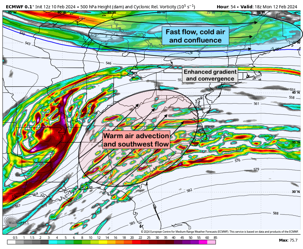
As you may imagine, forecast models are having a terrible time with this one. Most guidance has waffled back and forth for the better part of three days regarding whether or not NYC will see notable snowfall from this storm. Conventional wisdom argues against it initially, with warm temperatures in place and a very marginal setup characterized by warm air surging towards the area.
However, as the low pressure system forms to our south, cold air will begin to wrap in towards the area on Tuesday afternoon. This could aid in changing precipitation over to snow from west to east, resulting in a few hours of accumulating snowfall across the NYC Metro area. Obviously, the difference between several hours of snow and a few hours of snow will have major implications.
After trending warmer for several days, recent model data has gone the other direction – most guidance today is colder, suggesting that precipitation will flip over to snow in NYC on Tuesday afternoon and stay that way for several hours. The result would be the potential for least a few inches of snowfall. The warmer scenario would mean very little accumulating snowfall at all.
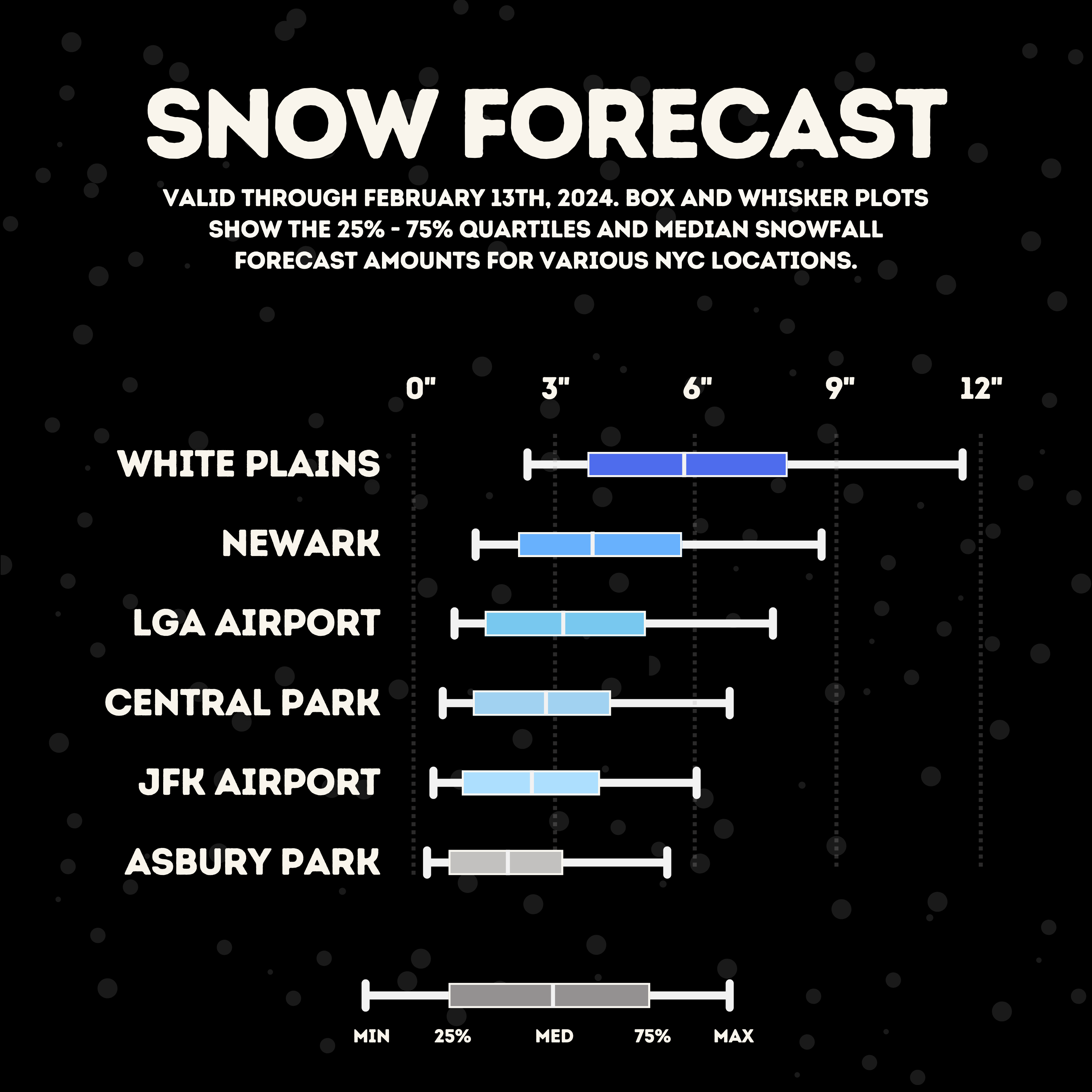
As a result, we’re taking a middle ground with this forecast and suggesting that 1 to 3 inches of snow will fall in NYC proper, and a more notable 3 to 6 inches in the interior and higher elevations. A colder trend as we approach the event could result in these amounts increasing incrementally. The box and whisker plots, which we use to visualize uncertainty and distribution of possibilities, show an unusually large dispersion on the upper bounds of the forecast. In other words, larger and more significant snowfall totals are still on the table.
Timing: Precipitation is expected to begin late Monday evening and during the early morning hours of Tuesday, likely as rain or a wintry mix in NYC and a wintry mix or snow in Northern NJ, Upstate NY, and Connecticut. This sloppy mix will continue in NYC into Tuesday morning as snow becomes heavier in the interior.
By late Tuesday morning or Tuesday afternoon, we’ll reach the inflection point with this system. If the changeover to snow begins, we’ll be in for a long afternoon. If rain or a mix holds, we’ll likely escape any significant impacts. Regardless, a changeover to snow will occur at some point Tuesday afternoon, raising at least some concern for slippery conditions during the Tuesday evening commute. Thereafter, the system will gradually end from west to east.
In the coming 12-24 hours, we should begin to get a much better idea as to how the system will evolve. This will allow us to tighten the envelope of possibilities and gain confidence in exactly what to expect in the NYC Metro area.
Tl;dr: A winter storm will impact the area on Tuesday, but uncertainty is unusually high regarding the details. 1 to 3 inches of snow is currently forecast in NYC with 3 to 6 inches in the higher elevations and interior of Northern NJ, Southeast NY and CT. Significant adjustments to the forecast are still possible in the next 12 hours.
An impressive share, I just given this onto a colleague who was doing a little analysis on this. And he in fact bought me breakfast because I found it for him.. smile. So let me reword that: Thnx for the treat! But yeah Thnkx for spending the time to discuss this, I feel strongly about it and love reading more on this topic. If possible, as you become expertise, would you mind updating your blog with more details? It is highly helpful for me. Big thumb up for this blog post!
Loving the information on this internet site, you have done outstanding job on the posts.
Oh my goodness! an incredible article dude. Thank you However I am experiencing challenge with ur rss . Don’t know why Unable to subscribe to it. Is there anybody getting equivalent rss problem? Anyone who is aware of kindly respond. Thnkx
I’m often to running a blog and i really admire your content. The article has really peaks my interest. I am going to bookmark your website and preserve checking for brand spanking new information.
F*ckin’ tremendous things here. I’m very glad to peer your post. Thanks a lot and i’m having a look ahead to touch you. Will you kindly drop me a mail?
Hello, you used to write excellent, but the last several posts have been kinda boring… I miss your super writings. Past few posts are just a little bit out of track! come on!
You made some respectable points there. I looked on the internet for the difficulty and located most individuals will go along with along with your website.
Wonderful goods from you, man. I have understand your stuff previous to and you are just extremely magnificent. I actually like what you’ve acquired here, really like what you’re stating and the way in which you say it. You make it enjoyable and you still take care of to keep it sensible. I cant wait to read far more from you. This is really a tremendous site.
Very interesting info!Perfect just what I was looking for!
Definitely, what a great blog and educative posts, I will bookmark your blog.All the Best!
I feel this is among the most significant information for me. And i am happy reading your article. However want to remark on few basic things, The site taste is perfect, the articles is actually excellent :D. Excellent process, cheers
We’re a group of volunteers and opening a new scheme in our community. Your web site provided us with valuable info to work on. You have performed an impressive job and our entire group will be thankful to you.
Pretty nice post. I just stumbled upon your weblog and wanted to say that I have really enjoyed browsing your blog posts. After all I’ll be subscribing to your feed and I hope you write again very soon!
Along with every little thing which seems to be developing throughout this particular subject matter, many of your perspectives happen to be somewhat refreshing. Even so, I am sorry, but I do not subscribe to your whole theory, all be it exciting none the less. It looks to me that your commentary are not completely rationalized and in simple fact you are your self not really fully confident of the argument. In any event I did appreciate looking at it.
hi!,I like your writing so much! share we communicate more about your article on AOL? I need a specialist on this area to solve my problem. May be that’s you! Looking forward to see you.
Hi my loved one! I want to say that this article is amazing, great written and include almost all important infos. I’d like to see extra posts like this.
Hey, you used to write great, but the last few posts have been kinda boringK I miss your tremendous writings. Past several posts are just a bit out of track! come on!
This text is invaluable. How can I find out more?
You could certainly see your skills within the work you write. The arena hopes for more passionate writers such as you who are not afraid to mention how they believe. Always follow your heart. “He never is alone that is accompanied with noble thoughts.” by Fletcher.
I think this is one of the most significant information for me. And i am glad reading your article. But should remark on few general things, The web site style is perfect, the articles is really nice :D. Good job, cheers
I will right away clutch your rss as I can’t in finding your email subscription hyperlink or newsletter service. Do you’ve any? Kindly let me realize in order that I may subscribe. Thanks.
Nice read, I just passed this onto a colleague who was doing some research on that. And he actually bought me lunch since I found it for him smile Therefore let me rephrase that: Thank you for lunch! “A human being has a natural desire to have more of a good thing than he needs.” by Mark Twain.
I dugg some of you post as I thought they were extremely helpful very beneficial
Having read this I thought it was very informative. I appreciate you taking the time and effort to put this article together. I once again find myself spending way to much time both reading and commenting. But so what, it was still worth it!
But wanna state that this is very helpful, Thanks for taking your time to write this.
I was curious if you ever considered changing the page layout of your site? Its very well written; I love what youve got to say. But maybe you could a little more in the way of content so people could connect with it better. Youve got an awful lot of text for only having one or 2 pictures. Maybe you could space it out better?
I keep listening to the news broadcast speak about receiving free online grant applications so I have been looking around for the best site to get one. Could you tell me please, where could i acquire some?
hello!,I like your writing so a lot! share we keep up a correspondence more about your post on AOL? I require an expert in this space to resolve my problem. May be that is you! Having a look ahead to look you.
Hi there very cool blog!! Man .. Beautiful .. Amazing .. I’ll bookmark your web site and take the feeds additionally…I’m glad to seek out so many useful information here in the submit, we need work out extra strategies in this regard, thank you for sharing.
I believe you have noted some very interesting details, appreciate it for the post.
I’m really enjoying the design and layout of your website.
It’s a very easy on the eyes which makes it much more enjoyable for me to come here and visit more often.
Did you hire out a developer to create your theme? Fantastic work!
Most of the things you say is supprisingly legitimate and that makes me ponder why I had not looked at this with this light previously. Your piece truly did turn the light on for me as far as this issue goes. But there is just one point I am not too comfortable with so whilst I make an effort to reconcile that with the actual main idea of the point, allow me see just what the rest of the subscribers have to point out.Very well done.
Perfect piece of work you have done, this site is really cool with fantastic info .
Nice post. I learn something more challenging on different blogs everyday. It will always be stimulating to read content from other writers and practice a little something from their store. I’d prefer to use some with the content on my blog whether you don’t mind. Natually I’ll give you a link on your web blog. Thanks for sharing.
Its like you learn my mind! You seem to understand a lot approximately this, like you wrote the e-book in it or something. I believe that you could do with a few percent to drive the message house a bit, however instead of that, that is great blog. A great read. I’ll definitely be back.
My family always say that I am wasting my time here at web,
except I know I am getting experience everyday by reading thes pleasant articles.
I have read a few good stuff here. Definitely worth bookmarking for revisiting. I wonder how much effort you put to make such a great informative website.
I’m no longer sure the place you’re getting your info, but great topic. I must spend some time finding out more or figuring out more. Thanks for magnificent information I used to be searching for this info for my mission.
Generally I do not learn article on blogs, but I would like to say that this write-up very compelled me to try and do so! Your writing style has been amazed me. Thanks, very nice article.
I don’t unremarkably comment but I gotta say appreciate it for the post on this special one :D.
I was very happy to search out this internet-site.I wanted to thanks for your time for this glorious learn!! I positively enjoying each little little bit of it and I have you bookmarked to take a look at new stuff you blog post.
Hi would you mind letting me know which web host you’re utilizing?
I’ve loaded your blog in 3 different web browsers and I must
say this blog loads a lot faster then most. Can you suggest a good web hosting provider at
a reasonable price? Thanks a lot, I appreciate it!
Hmm it seems like your site ate my first comment (it was extremely long) so I guess I’ll just sum it up what I submitted and say, I’m thoroughly enjoying your blog. I too am an aspiring blog blogger but I’m still new to everything. Do you have any points for beginner blog writers? I’d genuinely appreciate it.
This actually answered my problem, thanks!
Thank you for sharing superb informations. Your website is so cool. I am impressed by the details that you have on this blog. It reveals how nicely you understand this subject. Bookmarked this website page, will come back for more articles. You, my friend, ROCK! I found just the info I already searched everywhere and just couldn’t come across. What an ideal web site.
I have learn some excellent stuff here. Definitely value bookmarking for revisiting. I wonder how much attempt you place to create such a excellent informative website.
I think the admin of this site is actually working hard in support of his website,
for the reason that here every information is quality based data.
Generally I do not read article on blogs, but I would like to say that this write-up very forced me to try and do it! Your writing style has been amazed me. Thanks, quite nice article.
Sweet website , super layout, really clean and utilise pleasant.
I’ll right away grab your rss as I can’t find your e-mail subscription link or newsletter service. Do you have any? Please let me know in order that I could subscribe. Thanks.
Hello, i read your blog from time to time and i own a similar one and i was just curious if you get a lot of spam responses? If so how do you reduce it, any plugin or anything you can advise? I get so much lately it’s driving me crazy so any assistance is very much appreciated.
Hey very nice blog!! Man .. Excellent .. Amazing .. I will bookmark your site and take the feeds also…I’m happy to find a lot of useful information here in the post, we need develop more strategies in this regard, thanks for sharing. . . . . .
I and my friends ended up checking out the best thoughts from your web site while all of the sudden got an awful feeling I never expressed respect to the web site owner for those techniques. My boys are actually for this reason very interested to read them and have in effect without a doubt been enjoying them. Appreciate your being quite kind and then for picking out certain good subject areas millions of individuals are really needing to be informed on. Our own sincere apologies for not expressing gratitude to you earlier.
Hello! This post could not be written any better! Reading this post reminds me of my old room mate! He always kept chatting about this. I will forward this article to him. Fairly certain he will have a good read. Many thanks for sharing!
An interesting discussion is worth comment. I think that you should write more on this topic, it might not be a taboo subject but generally people are not enough to speak on such topics. To the next. Cheers
Thanks, I have just been looking for information approximately this topic for a long time and yours is the greatest I’ve found out till now. But, what in regards to the bottom line? Are you positive in regards to the source?
Some truly wonderful info , Gladiola I detected this. “The distance between insanity and genius is measured only by success.” by James Bond Tomorrow Never Dies.
I was studying some of your posts on this website and I think this website is very informative! Keep posting.
Absolutely indited articles, Really enjoyed looking through.
Hello just wanted to give you a brief heads up and let you know a few of the images aren’t loading properly. I’m not sure why but I think its a linking issue. I’ve tried it in two different internet browsers and both show the same results.
I am very happy to read this. This is the type of manual that needs to be given and not the random misinformation that’s at the other blogs. Appreciate your sharing this best doc.
Hi! I’m at work surfing around your blog from my new iphone 3gs! Just wanted to say I love reading through your blog and look forward to all your posts! Keep up the outstanding work!
Hi there, I discovered your website via Google even as looking for a comparable topic, your site came up, it seems good. I’ve bookmarked it in my google bookmarks.
Very excellent information can be found on web blog.
Hello there, I discovered your blog via Google whilst searching for a comparable subject, your site came up, it looks good. I’ve bookmarked it in my google bookmarks.
Great, I should certainly pronounce, impressed with your website. I had no trouble navigating through all the tabs and related info ended up being truly simple to do to access. I recently found what I hoped for before you know it at all. Quite unusual. Is likely to appreciate it for those who add forums or something, web site theme . a tones way for your client to communicate. Excellent task.
Loving the information on this website , you have done great job on the content.
Very interesting details you have noted, thankyou for posting. “The best time to do a thing is when it can be done.” by William Pickens.
I have read some excellent stuff here. Certainly price bookmarking for revisiting. I wonder how so much effort you set to make this kind of great informative website.
Does your blog have a contact page? I’m having a tough time locating it but, I’d like to send you an e-mail. I’ve got some suggestions for your blog you might be interested in hearing. Either way, great website and I look forward to seeing it improve over time.
I like this site so much, saved to fav. “I don’t care what is written about me so long as it isn’t true.” by Dorothy Parker.
Someone necessarily help to make significantly posts I would state. This is the very first time I frequented your web page and so far? I amazed with the research you made to create this particular publish extraordinary. Fantastic job!
An impressive share, I just given this onto a colleague who was doing a little analysis on this. And he in fact bought me breakfast because I found it for him.. smile. So let me reword that: Thnx for the treat! But yeah Thnkx for spending the time to discuss this, I feel strongly about it and love reading more on this topic. If possible, as you become expertise, would you mind updating your blog with more details? It is highly helpful for me. Big thumb up for this blog post!
you’re truly a excellent webmaster. The site loading velocity is incredible. It seems that you are doing any distinctive trick. Moreover, The contents are masterpiece. you’ve done a wonderful process on this subject!
I was just seeking this info for some time. After 6 hours of continuous Googleing, at last I got it in your site. I wonder what’s the lack of Google strategy that don’t rank this type of informative sites in top of the list. Usually the top websites are full of garbage.
I couldn’t resist commenting
Heya are using WordPress for your blog platform? I’m new to the blog world but I’m trying to get started and create my own. Do you require any coding knowledge to make your own blog? Any help would be really appreciated!
Excellent blog here! Also your site loads up fast!
What web host are you using? Can I get your affiliate link to your
host? I wish my website loaded up as quickly as yours lol
You made some decent points there. I checked on the web for more information about the issue and found most individuals
will go along with your views on this web site.
We stumbled over here coming from a different website and thought I may as well check things out.
I like what I see so i am just following you. Look forward to finding out about your web page for a second
time.
I wanted to thank you for this great read!! I definitely enjoying every little bit of it I have you bookmarked to check out new stuff you post…
Wonderful items from you, man. I have keep in mind
your stuff previous to and you are simply too magnificent.
I actually like what you have bought here, really like what you are stating and the way in which
wherein you are saying it. You’re making it enjoyable and you continue to care
for to keep it smart. I cant wait to read much more from you.
That is actually a wonderful web site.
Have you ever thought about adding a little bit more than just your articles? I mean, what you say is valuable and all. However think of if you added some great visuals or videos to give your posts more, “pop”! Your content is excellent but with pics and clips, this blog could undeniably be one of the most beneficial in its niche. Terrific blog!
Only wanna input on few general things, The website layout is perfect, the subject matter is real excellent : D.
Why users still use to read news papers when in this technological globe
the whole thing is available on net?
Wonderful work! This is the type of information that should be shared around the internet. Shame on Google for not positioning this post higher! Come on over and visit my site . Thanks =)
Wow, marvelous blog layout! How lengthy have you been running a blog for? you made blogging look easy. The overall glance of your site is excellent, as smartly as the content material!
I really glad to find this site on bing, just what I was looking for : D likewise saved to favorites.
I would like to show my appreciation for your generosity supporting folks that have the need for help on this particular theme. Your personal dedication to getting the message all-around appears to be especially productive and has made guys like me to attain their targets. Your own warm and friendly guide implies a whole lot to me and further more to my peers. With thanks; from all of us.
Great post. I am facing a couple of these problems.
When someone writes an post he/she maintains the thought of a user in his/her mind that how a user
can be aware of it. Therefore that’s why
this post is great. Thanks!
This piece of writing is actually a pleasant one it
helps new internet people, who are wishing in favor of blogging.
Hiya very cool site!! Guy .. Beautiful .. Amazing .. I will bookmark your site and take the feeds alsoKI’m happy to find numerous helpful info here in the publish, we need work out more strategies in this regard, thanks for sharing. . . . . .
Hey, you used to write fantastic, but the last few posts have been kinda boring?K I miss your great writings. Past few posts are just a bit out of track! come on!
Just want to say your article is as surprising. The clarity in your post is simply great and i can assume you’re an expert on this subject. Fine with your permission allow me to grab your feed to keep updated with forthcoming post. Thanks a million and please carry on the gratifying work.
Some truly interesting points you have written.Assisted me a lot, just what I was searching for :D.
Great work! This is the kind of info that are meant to be shared across the web. Shame on the search engines for now not positioning this submit higher! Come on over and talk over with my web site . Thanks =)
I was just looking for this information for a while. After 6 hours of continuous Googleing, finally I got it in your website. I wonder what is the lack of Google strategy that don’t rank this type of informative websites in top of the list. Usually the top web sites are full of garbage.
Electronic Business Card – The Smart Card. Create and share your professional electronic business card easily. In minutes. Choose from 100+ templates, connect with clients, and grow your business today!
I truly enjoy reading on this site, it has fantastic articles. “One should die proudly when it is no longer possible to live proudly.” by Friedrich Wilhelm Nietzsche.
Definitely, what a great site and instructive posts, I definitely will bookmark your blog.Best Regards!
Wow! This blog looks just like my old one! It’s on a totally different subject but it has pretty much the same layout and design. Superb choice of colors!
An interesting discussion is worth comment. I think that you should write more on this topic, it might not be a taboo subject but generally people are not enough to speak on such topics. To the next. Cheers
It’s really a nice and useful piece of information. I’m glad that you shared this helpful information with us. Please keep us informed like this. Thanks for sharing.
As a Newbie, I am permanently browsing online for articles that can benefit me. Thank you
I have read several just right stuff here. Certainly price bookmarking for revisiting. I wonder how so much attempt you put to create any such magnificent informative site.
It’s appropriate time to make some plans for the long run and it is time to be happy. I’ve read this put up and if I may just I wish to counsel you few attention-grabbing issues or tips. Perhaps you can write next articles referring to this article. I wish to read more things about it!
I got what you intend, regards for posting.Woh I am glad to find this website through google.
I like what you guys are up also. Such smart work and reporting! Keep up the superb works guys I’ve incorporated you guys to my blogroll. I think it will improve the value of my site :).
This is a very good tips especially to those new to blogosphere, brief and accurate information… Thanks for sharing this one. A must read article.
fantastic post, very informative. I wonder why the other experts of this sector don’t notice this. You should continue your writing. I am confident, you’ve a huge readers’ base already!
Good day! I could have sworn I’ve been to this blog before but after browsing through some of the post I realized it’s new to me.
Nonetheless, I’m definitely happy I found it and I’ll be book-marking and checking back often!
It’s actually a great and helpful piece of
information. I am happy that you shared this
useful information with us. Please keep us informed like this.
Thanks for sharing.
Magnificent beat ! I wish to apprentice while you amend your web site,
how could i subscribe for a weblog site? The account aided me
a appropriate deal. I have been tiny bit acquainted
of this your broadcast offered brilliant transparent idea
It’s awesome to go to see this site and reading the views
of all mates about this piece of writing, while I am also eager of
getting knowledge.
Why people still use to read news papers when in this technological
world the whole thing is existing on web?
Hi! Quick question that’s entirely off topic. Do you know how to make your site mobile friendly? My weblog looks weird when viewing from my apple iphone. I’m trying to find a theme or plugin that might be able to fix this problem. If you have any suggestions, please share. Cheers!
You are my aspiration, I have few web logs and sometimes run out from to post .
Normally I don’t learn post on blogs, but I would like to say that this write-up very pressured me to take a look at and do it! Your writing style has been amazed me. Thank you, quite great post.
Write more, thats all I have to say. Literally, it seems as though you relied on the video to make your point. You clearly know what youre talking about, why throw away your intelligence on just posting videos to your weblog when you could be giving us something enlightening to read?
Valuable info. Lucky me I found your web site by chance, and I am surprised why this twist of fate did not took place earlier! I bookmarked it.
This is a topic close to my heart cheers, where are your contact details though?
Hello, i think that i saw you visited my blog so i came to “return the favor”.I am attempting to find things to enhance my website!I suppose its ok to use a few of your ideas!!
Thank you, I’ve just been looking for info about this topic for a while and yours is the best I have came upon till now. But, what concerning the conclusion? Are you sure in regards to the supply?
I do agree with all the ideas you’ve presented in your post. They’re really convincing and will definitely work. Still, the posts are very short for starters. Could you please extend them a little from next time? Thanks for the post.
I genuinely enjoy reading through on this internet site, it holds superb blog posts. “I have a new philosophy. I’m only going to dread one day at a time.” by Charles M. Schulz.
I actually wanted to type a small message to thank you for those precious secrets you are sharing at this site. My rather long internet look up has at the end of the day been recognized with reputable points to exchange with my company. I ‘d declare that most of us readers are extremely fortunate to dwell in a wonderful site with many perfect professionals with good strategies. I feel extremely privileged to have discovered your webpage and look forward to plenty of more enjoyable minutes reading here. Thank you once more for a lot of things.
I am glad to be a visitant of this unadulterated weblog! , thanks for this rare info ! .
I respect your piece of work, thankyou for all the useful posts.
I enjoy the efforts you have put in this, appreciate it for all the great blog posts.
Great post. I am facing a couple of these problems.
Hey there just wanted to give you a brief heads up and let you know a few of the pictures aren’t loading properly.
I’m not sure why but I think its a linking issue. I’ve
tried it in two different internet browsers and both
show the same outcome.
Having read this I thought it was very informative. I appreciate you taking the time and effort to put this article together. I once again find myself spending way to much time both reading and commenting. But so what, it was still worth it!
Nice post. I used to be checking constantly this weblog and I am inspired! Very useful info particularly the remaining part 🙂 I care for such info much. I was looking for this certain information for a long time. Thank you and good luck.
I went over this site and I think you have a lot of excellent information, saved to fav (:.
Loving the information on this web site, you have done outstanding job on the posts.
I would like to thnkx for the efforts you have put in writing this blog. I am hoping the same high-grade blog post from you in the upcoming as well. In fact your creative writing abilities has inspired me to get my own blog now. Really the blogging is spreading its wings quickly. Your write up is a good example of it.
Amazing blog! Is your theme custom made or did you download it from somewhere? A theme like yours with a few simple adjustements would really make my blog shine. Please let me know where you got your design. Thanks a lot
Great paintings! This is the kind of information that are meant to be shared across the internet. Disgrace on the seek engines for not positioning this publish higher! Come on over and visit my site . Thanks =)
Very good site you have here but I was wanting to know if you knew of any discussion boards that cover the same topics talked about here? I’d really love to be a part of group where I can get feedback from other knowledgeable individuals that share the same interest. If you have any suggestions, please let me know. Thank you!
I am no longer certain where you’re getting your information, but great topic. I must spend a while finding out more or working out more. Thank you for wonderful info I used to be searching for this information for my mission.
You can certainly see your enthusiasm in the work you write. The sector hopes for more passionate writers like you who aren’t afraid to mention how they believe. All the time follow your heart.
Great paintings! This is the type of info that are supposed to be shared around the net. Disgrace on the search engines for now not positioning this put up upper! Come on over and talk over with my web site . Thank you =)
The next time I read a blog, I hope that it doesnt disappoint me as much as this one. I mean, I know it was my choice to read, but I actually thought youd have something interesting to say. All I hear is a bunch of whining about something that you could fix if you werent too busy looking for attention.
GAJAH138 lumayan menarik menjadi link login situs game Android serta
iOS di Nusantara. Aksesnya berasa ringkas serta penampilannya
ringan dimengerti, sampai untuk pemakai anyar.
gajah138 Slots deposit 10k cepat dan mudah bisnis cuman modal 10k
bisa bermain secara ringan serta dijamin nyaman, main saat ini pula
Great post, I think people should learn a lot from this website its real user genial.
Magnificent items from you, man. I have take note your stuff prior to and you are simply extremely great. I really like what you’ve obtained right here, certainly like what you are saying and the way by which you assert it. You are making it entertaining and you still care for to keep it smart. I cant wait to learn much more from you. This is actually a tremendous website.
Hiya, I am really glad I have found this info. Today bloggers publish only about gossips and internet and this is really frustrating. A good site with exciting content, this is what I need. Thanks for keeping this site, I’ll be visiting it. Do you do newsletters? Can’t find it.
hello world
Good website! I really love how it is easy on my eyes and the data are well written. I’m wondering how I might be notified whenever a new post has been made. I’ve subscribed to your RSS which must do the trick! Have a great day!
Some really superb articles on this internet site, appreciate it for contribution.
It’s perfect time to make some plans for the future and it’s time to be happy. I’ve read this post and if I could I want to suggest you some interesting things or tips. Perhaps you could write next articles referring to this article. I wish to read even more things about it!
Hey there I am so glad I found your webpage, I really found you by error, while I was browsing on Yahoo for something else, Anyhow I am here now and would just like to say many thanks for a incredible post and a all round exciting blog (I also love the theme/design), I don’t have time to read it all at the minute but I have bookmarked it and also included your RSS feeds, so when I have time I will be back to read more, Please do keep up the superb job.
Nice blog here! Also your site loads up very fast! What host are you the use of? Can I am getting your associate hyperlink for your host? I desire my website loaded up as quickly as yours lol
I adore looking at and I believe this website got some truly utilitarian stuff on it! .
I enjoy your writing style genuinely loving this website .
I got what you intend,saved to favorites, very nice web site.
I genuinely enjoy examining on this internet site, it holds excellent blog posts. “Do what you fear, and the death of fear is certain.” by Anthony Robbins.
Excellent beat ! I wish to apprentice while you amend your website, how can i subscribe for a blog website? The account aided me a acceptable deal. I had been tiny bit acquainted of this your broadcast offered bright clear idea
I’m impressed, I must say. Really not often do I encounter a blog that’s both educative and entertaining, and let me inform you, you have got hit the nail on the head. Your concept is excellent; the issue is one thing that not enough people are speaking intelligently about. I am very comfortable that I stumbled throughout this in my search for one thing relating to this.
I got what you intend, thankyou for posting.Woh I am glad to find this website through google.
I like this site very much so much superb information.
I very delighted to find this site on bing, just what I was looking for : D besides bookmarked.
Hi, i think that i saw you visited my blog so i came to “return the favor”.I’m trying to find things to enhance my website!I suppose its ok to use some of your ideas!!
Hi there very nice site!! Man .. Beautiful .. Wonderful .. I’ll bookmark your site and take the feeds additionally…I’m glad to find numerous helpful information right here within the post, we’d like work out more strategies on this regard, thanks for sharing.
Pretty! This was a really wonderful post. Thank you for your provided information.
Very nice post. I just stumbled upon your weblog and wanted to say that I’ve really enjoyed browsing your blog posts. After all I’ll be subscribing to your feed and I hope you write again very soon!
I was studying some of your content on this website and I think this internet site is real informative! Keep on posting.
Thanks for sharing your thoughts about nude white girls.
Regards
Good website! I truly love how it is simple on my eyes and the data are well written. I’m wondering how I might be notified whenever a new post has been made. I’ve subscribed to your RSS which must do the trick! Have a nice day!
I am no longer sure where you are getting your information, but good topic. I needs to spend a while finding out much more or working out more. Thanks for magnificent information I was searching for this information for my mission.
부산출장마사지란 전문 마사지 관리사가 고객이 있는 부산 지역 내 자택, 호텔, 숙소, 사무실 등 원하는 장소로 직접 방문하여 마사지를 제공하는 서비스(홈케어)
Thanks for sharing excellent informations. Your web site is so cool. I am impressed by the details that you’ve on this web site. It reveals how nicely you perceive this subject. Bookmarked this web page, will come back for extra articles. You, my pal, ROCK! I found simply the information I already searched all over the place and simply couldn’t come across. What an ideal website.
Very nice post. I just stumbled upon your weblog and wished to say that I’ve truly enjoyed browsing your blog posts. After all I will be subscribing to your feed and I hope you write again very soon!
Very interesting subject , regards for posting.
I’m still learning from you, as I’m trying to achieve my goals. I absolutely love reading all that is posted on your site.Keep the tips coming. I liked it!
Really superb visual appeal on this site, I’d value it 10 10.
I would like to thank you for the efforts you’ve put in writing this web site. I’m hoping the same high-grade site post from you in the upcoming also. In fact your creative writing skills has inspired me to get my own web site now. Really the blogging is spreading its wings quickly. Your write up is a good example of it.
Great blog here! Also your web site loads up very fast! What web host are you using? Can I get your affiliate link to your host? I wish my web site loaded up as fast as yours lol
Hey there are using WordPress for your site platform?
I’m new to the blog world but I’m trying to get started and create my own. Do
you require any coding expertise to make your own blog?
Any help would be greatly appreciated!
It’s really a cool and helpful piece of info. I am glad that you simply shared this helpful info with us. Please stay us up to date like this. Thank you for sharing.
An interesting dialogue is worth comment. I think that it is best to write more on this topic, it may not be a taboo topic however typically people are not enough to speak on such topics. To the next. Cheers
I must voice my love for your kindness for folks who really need help on this subject. Your very own dedication to passing the solution around appears to be pretty functional and has surely enabled somebody just like me to arrive at their goals. Your amazing invaluable recommendations denotes a great deal to me and additionally to my fellow workers. Warm regards; from everyone of us.
This really answered my problem, thank you!
I believe this website has got some very good information for everyone :D. “We rarely think people have good sense unless they agree with us.” by Francois de La Rochefoucauld.
Heya i am for the first time here. I found this board and I find It really useful & it helped me out a lot. I hope to give something back and aid others like you aided me.
Hello, you used to write great, but the last few posts have been kinda boring?K I miss your great writings. Past several posts are just a little out of track! come on!
I think this is among the most vital information for me. And i am glad reading your article. But wanna remark on some general things, The web site style is perfect, the articles is really nice :D. Good job, cheers
Regards for helping out, superb info. “A man will fight harder for his interests than for his rights.” by Napoleon Bonaparte.
I’ve read a few just right stuff here. Definitely worth bookmarking for revisiting. I wonder how much attempt you set to make any such fantastic informative website.
Howdy! This is my 1st comment here so I just wanted to give
a quick shout out and tell you I really enjoy reading through your articles.
Can you recommend any other blogs/websites/forums that deal with the same subjects?
Thanks for your time!
I am lucky that I discovered this site, just the right information that I was looking for! .
Some really wonderful information, Sword lily I noticed this. “Now hatred is by far the longest pleasure men love in haste but they detest at leisure.” by George Gordon Byron.
Some genuinely good posts on this internet site, thank you for contribution. “The key to everything is patience. You get the chicken by hatching the egg, not by smashing it.” by Arnold Glasgow.
Great site! I am loving it!! Will be back later to read some more. I am bookmarking your feeds also.
I was wondering if you ever thought of changing the page layout of your site? Its very well written; I love what youve got to say. But maybe you could a little more in the way of content so people could connect with it better. Youve got an awful lot of text for only having 1 or two images. Maybe you could space it out better?
I believe you have noted some very interesting points, thanks for the post.
I like what you guys tend to be up too. Such clever work and exposure!
Keep up the awesome works guys I’ve added you guys to
my own blogroll.
Hi, i read your blog from time to time and i own a similar one and i was just wondering if you get a lot of spam feedback? If so how do you reduce it, any plugin or anything you can advise? I get so much lately it’s driving me mad so any assistance is very much appreciated.
I gotta bookmark this internet site it seems very helpful very useful
Hello everyone, it’s my first pay a quick visit at this website, and post is in fact fruitful in favor of me,
keep up posting these articles or reviews.
I got what you intend, thanks for putting up.Woh I am thankful to find this website through google.
Hello there, I found your web site via Google while searching for a related topic, your web site came up, it looks great. I’ve bookmarked it in my google bookmarks.
Valuable information. Lucky me I found your site by accident, and I am shocked why this accident did not happened earlier! I bookmarked it.
Just a smiling visitant here to share the love (:, btw outstanding pattern.
Excellent article. I’m going through many of these issues as well..
I am glad to be a visitant of this thoroughgoing web blog! , thanks for this rare info ! .
Some genuinely interesting info , well written and broadly speaking user friendly.
Kemashyuran MACAUGG kian bertambah lantaran dapat mendatangkan kondisi permainan yang terus berkembang tiap-tiap hari.
Banyak pemakai suka sama keringanan akses lewat
piranti mobile ataupun desktop, agar rutinitas bisa dijalankan {} lebih fleksibel.
Gabungan di antara pelayanan yang konstan serta perubahan info yang lebih
cepat menjadi daya magnet khusus untuk beberapa pemakainya.
I have read a few just right stuff here. Certainly price bookmarking for revisiting. I surprise how much attempt you put to make this kind of excellent informative website.
Very interesting points you have remarked, thankyou for putting up. “There is nothing in a caterpillar that tells you it’s going to be a butterfly.” by Richard Buckminster Fuller.
I think you have noted some very interesting points, thankyou for the post.
I truly appreciate this post. I’ve been looking everywhere for this! Thank goodness I found it on Bing. You’ve made my day! Thank you again!
What’s Taking place i’m new to this, I stumbled upon this I’ve found It positively useful and it has helped me out loads. I am hoping to contribute & assist other users like its aided me. Great job.
Thanks on your marvelous posting! I truly
enjoyed reading it, you are a great author.I will make certain to bookmark your blog and
definitely will come back later in life. I want to
encourage one to continue your great work, have a nice day!
whoah this blog is magnificent i love reading your posts. Keep up the good work! You know, many people are looking around for this info, you could help them greatly.
Very interesting details you have observed, appreciate it for putting up. “These days an income is something you can’t live without–or within.” by Tom Wilson.
I will right away grab your rss feed as I can not to find your e-mail subscription link or e-newsletter service. Do you’ve any? Kindly permit me know in order that I may just subscribe. Thanks.
I don’t even know how I ended up here, but I thought this post was great. I do not know who you are but definitely you’re going to a famous blogger if you are not already 😉 Cheers!
As I website possessor I believe the content material here is rattling great , appreciate it for your hard work. You should keep it up forever! Best of luck.
It is best to take part in a contest for top-of-the-line blogs on the web. I’ll suggest this site!
Normally I don’t read post on blogs, but I wish to say that this write-up very pressured me to check out and do so! Your writing taste has been surprised me. Thank you, quite nice article.
I do not even know how I ended up here, but I thought this post was great. I do not know who you are but definitely you’re going to a famous blogger if you are not already 😉 Cheers!
Hello There. I found your blog using msn. This is a very well written article. I’ll make sure to bookmark it and come back to read more of your useful info. Thanks for the post. I’ll certainly return.
It’s a shame you don’t have a donate button! I’d certainly donate to this fantastic blog! I suppose for now i’ll settle for bookmarking and adding your RSS feed to my Google account. I look forward to fresh updates and will share this site with my Facebook group. Chat soon!
I was curious if you ever considered changing the structure of your blog? Its very well written; I love what youve got to say. But maybe you could a little more in the way of content so people could connect with it better. Youve got an awful lot of text for only having 1 or two pictures. Maybe you could space it out better?
Perfect piece of work you have done, this internet site is really cool with fantastic info .
Greetings! Very helpful advice on this article! It is the little changes that make the biggest changes. Thanks a lot for sharing!
Hello, Neat post. There is a problem along with
your site in internet explorer, might check this? IE nonetheless is the marketplace leader and a big component to people will
miss your great writing because of this problem.
Does your site have a contact page? I’m having problems locating it but, I’d like to shoot you an e-mail. I’ve got some recommendations for your blog you might be interested in hearing. Either way, great blog and I look forward to seeing it grow over time.
Great beat ! I wish to apprentice at the same time as you amend your website, how can i subscribe for a blog site? The account helped me a appropriate deal. I have been a little bit familiar of this your broadcast offered brilliant transparent concept
Hi, after reading this awesome paragraph i am as well delighted to share
my experience here with friends.
I believe this web site has got some very superb information for everyone :D.
I’m really enjoying the theme/design of your blog. Do you ever run into any web browser compatibility issues? A few of my blog readers have complained about my website not working correctly in Explorer but looks great in Safari. Do you have any ideas to help fix this problem?
Very nice post. I simply stumbled upon your blog and wished to mention that I have truly loved surfing around your blog posts. After all I will be subscribing for your feed and I am hoping you write once more very soon!
Wow! Thank you! I permanently wanted to write on my website something like that. Can I include a portion of your post to my site?
Very interesting details you have noted, thanks for putting up. “Pleasure and love are the pinions of great deeds.” by Charles Fox.
Aavant produces the best photography, event and theatre backdrops in the world and works for almost all the biggest players in the world. Being in backdrops industry for last two decades it is the largest player in the world, providing highest quality backdrops to every buyer from USA to Australia.
great post, very informative. I wonder why the other specialists of this sector do not notice this. You must continue your writing. I am confident, you have a huge readers’ base already!
My partner and I stumbled over here different website and thought I might as well check things out.
I like what I see so now i am following you. Look forward to exploring your web page
for a second time.
Wow! This blog looks just like my old one! It’s on a entirely different subject but it has pretty much the same page layout and design. Superb choice of colors!
Great site. Plenty of helpful info here. I am sending it to several pals ans also sharing in delicious. And obviously, thank you for your sweat!
Hello! I’m at work browsing your blog from my new iphone 3gs!
Just wanted to say I love reading through your blog and
look forward to all your posts! Carry on the outstanding work!
Howdy just wanted to give you a quick heads up. The text in your post seem to be running off the screen in Firefox.
I’m not sure if this is a format issue or something to do with web
browser compatibility but I thought I’d post to let you know.
The layout look great though! Hope you get the issue
solved soon. Many thanks
That is a really good tip especially to those new to the blogosphere.
Short but very accurate info… Many thanks for sharing this one.
A must read post!
Do you mind if I quote a few of your posts as long as I provide credit and sources back to your site? My website is in the very same niche as yours and my users would genuinely benefit from a lot of the information you present here. Please let me know if this ok with you. Thanks!
You actually make it appear so easy together with your presentation but I to find this matter to be actually something which I feel I might never understand. It sort of feels too complicated and very huge for me. I’m looking ahead for your next post, I’ll try to get the dangle of it!
you have a great blog here! would you like to make some invite posts on my blog?
Thank you for sharing with us, I think this website truly stands out :D.
Nice post. I was checking constantly this weblog and I am inspired!
Extremely useful info particularly the final section :
) I take care of such information a lot. I was looking
for this particular info for a very lengthy time. Thank you and good luck.
I take pleasure in, lead to I found just what I was taking a look for.
You have ended my 4 day lengthy hunt! God Bless you man. Have a nice day.
Bye
I have been exploring for a little bit for any high-quality articles or blog posts in this sort of space . Exploring in Yahoo I ultimately stumbled upon this website. Studying this info So i am happy to convey that I’ve a very excellent uncanny feeling I came upon exactly what I needed. I such a lot indubitably will make sure to don’t fail to remember this site and provides it a glance on a constant basis.
It’s actually a nice and useful piece of information. I am happy that you simply shared this useful information with us. Please stay us up to date like this. Thank you for sharing.
There’s noticeably a bundle to find out about this. I assume you made sure nice factors in options also.
Excellent post. I was checking constantly this blog and I’m impressed!
Extremely helpful information particularly the last part 🙂 I care for such information a lot.
I was looking for this certain info for a long time.
Thank you and best of luck.
I am often to blogging and i really respect your content. The article has really peaks my interest. I am going to bookmark your web site and maintain checking for brand spanking new information.
FNF VS Mickey Mouse Avi The Final Sunday Night has the kind of fast rhythm that makes FNF mods addictive. I would recommend trying it at least once.
I can see why people search for FNF Hatching The Harmony. The song and character setup make it stand out from basic FNF pages.
The theme in FNF Hatching The Harmony works nicely with the rhythm gameplay. It is a good option if you want something a little different.
I got what you mean ,saved to my bookmarks, very nice website .
Enjoyed looking at this, very good stuff, thankyou.
Terrific work! This is the type of information that should be shared around the web. Shame on the search engines for not positioning this post higher! Come on over and visit my web site . Thanks =)
Everything is very open and very clear explanation of issues. was truly information. Your website is very useful. Thanks for sharing.
Please let me know if you’re looking for a author for your blog. You have some really good articles and I think I would be a good asset. If you ever want to take some of the load off, I’d love to write some content for your blog in exchange for a link back to mine. Please shoot me an email if interested. Thanks!
Hi would you mind stating which blog platform you’re working with?
I’m going to start my own blog in the near future but I’m having a
tough time deciding between BlogEngine/Wordpress/B2evolution and Drupal.
The reason I ask is because your design seems different then most
blogs and I’m looking for something completely unique.
P.S Sorry for getting off-topic but I had to ask!
Howdy! I know this is somewhat off topic but I
was wondering if you knew where I could get a captcha plugin for my comment form?
I’m using the same blog platform as yours and I’m having trouble
finding one? Thanks a lot!
It is best to take part in a contest for the most effective blogs on the web. I’ll recommend this website!
I’ve been absent for some time, but now I remember why I used to love this blog. Thanks, I will try and check back more often. How frequently you update your website?
I have fun with, lead to I found exactly what I used to be looking for.
You’ve ended my four day lengthy hunt! God Bless you man. Have a
great day. Bye
Sweet web site, super design and style, rattling clean and utilize friendly.
Valuable info. Fortunate me I discovered your website accidentally, and I’m stunned why
this accident did not took place in advance! I
bookmarked it.
Very nice post. I just stumbled upon your weblog and wished to say that I have truly enjoyed browsing your
blog posts. After all I will be subscribing to your
rss feed and I hope you write again soon!
Hi! I know this is kinda off topic but I was wondering if you knew where I could locate a captcha plugin for my comment form? I’m using the same blog platform as yours and I’m having problems finding one? Thanks a lot!
Hi there! Someone in my Facebook group shared this website with us so I came to look it over. I’m definitely loving the information. I’m bookmarking and will be tweeting this to my followers! Great blog and fantastic design and style.
It’s an awesome post for all the online people; they will take benefit from it I am sure.
I was looking through some of your blog posts on this site and I conceive this web site is real instructive! Retain putting up.
I just could not depart your site prior to suggesting that I really loved the standard info an individual provide on your guests? Is going to be again often to check out new posts
I have recently started a web site, the info you provide on this website has helped me tremendously. Thanks for all of your time & work.
I am only commenting to make you know of the impressive experience my wife’s child experienced going through your blog. She mastered plenty of things, which include what it is like to have a wonderful coaching character to make folks completely master a number of impossible subject matter. You truly exceeded our own expected results. Thank you for churning out these beneficial, trusted, revealing and also easy thoughts on your topic to Tanya.
Wow, amazing weblog structure! How long have you ever been running
a blog for? you make running a blog glance easy. The total look
of your web site is great, let alone the content!
Hey would you mind letting me know which web host you’re using? I’ve loaded your blog in 3 different browsers and I must say this blog loads a lot quicker then most. Can you recommend a good internet hosting provider at a reasonable price? Thanks, I appreciate it!
Hey very cool site!! Man .. Excellent .. Amazing .. I’ll bookmark your blog and take the feeds also…I am happy to find numerous useful information here in the post, we need work out more strategies in this regard, thanks for sharing. . . . . .
We stumbled over here from a different web address and thought I might check things out.
I like what I see so now i’m following you. Look forward
to looking over your web page yet again.
I really like your writing style, great information, thank you for posting :D. “If a cluttered desk is the sign of a cluttered mind, what is the significance of a clean desk” by Laurence J. Peter.
Very good article. I’m facing many of these issues
as well..
Right now it looks like Expression Engine is the top blogging platform available right now. (from what I’ve read) Is that what you’re using on your blog?
Hurrah! In the end I got a blog from where I be capable of genuinely
take helpful facts concerning my study and knowledge.
I conceive this site has very great composed subject matter articles.
Very interesting info !Perfect just what I was looking for! “All the really good ideas I ever had came to me while I was milking a cow.” by Grant Wood.
What’s Happening i’m new to this, I stumbled upon this I’ve found It absolutely helpful and it has helped me out loads. I’m hoping to contribute & aid other users like its helped me. Good job.
When I originally commented I clicked the “Notify me when new comments are added” checkbox and now each time a comment is added I get four emails with the same comment. Is there any way you can remove people from that service? Bless you!
I have read so many content on the topic of the blogger lovers except this piece of writing is actually a fastidious post, keep
it up.
I love your blog.. very nice colors & theme. Did you create this website yourself? Plz reply back as I’m looking to create my own blog and would like to know wheere u got this from. thanks
Hi, Neat post. There’s a problem with your website in internet explorer, would check this… IE still is the market leader and a big portion of people will miss your great writing because of this problem.
You got a very excellent website, Glad I observed it through yahoo.
This web site is really a walk-through for all of the info you wanted about this and didn’t know who to ask. Glimpse here, and you’ll definitely discover it.
Great write-up, I’m regular visitor of one’s web site, maintain up the nice operate, and It’s going to be a regular visitor for a lengthy time.
You have mentioned very interesting details ! ps nice website .
I went over this internet site and I think you have a lot of fantastic info , saved to fav (:.
You have remarked very interesting details! ps nice internet site.
Outstanding post however I was wanting to know if you could write a litte more on this topic? I’d be very grateful if you could elaborate a little bit more. Thanks!
Great blog! Is your theme custom made or did you download it from somewhere? A design like yours with a few simple adjustements would really make my blog jump out. Please let me know where you got your theme. Cheers
Whoa! This blog looks exactly like my old one! It’s on a completely
different subject but it has pretty much the same layout and design. Wonderful
choice of colors!
What’s Happening i’m new to this, I stumbled upon this I’ve found It absolutely useful and it has aided me out loads. I hope to contribute & aid other users like its aided me. Great job.
Have you ever considered about including a little bit more than just
your articles? I mean, what you say is fundamental
and all. However imagine if you added some great visuals or video clips to give your posts more, “pop”!
Your content is excellent but with pics and video clips, this site could certainly
be one of the very best in its field. Great blog!
Hey just wanted to give you a brief heads up and let you know a few of the images aren’t loading correctly. I’m not sure why but I think its a linking issue. I’ve tried it in two different browsers and both show the same outcome.
I’ll right away grab your rss as I can not find your email subscription link or e-newsletter service. Do you have any? Kindly allow me realize so that I may subscribe. Thanks.
Perfectly composed articles, Really enjoyed reading through.
fantastic submit, very informative. I wonder why the other specialists
of this sector don’t realize this. You must proceed your
writing. I am confident, you’ve a great readers’ base already!
It is in point of fact a great and useful piece of information. I’m glad that you just shared this helpful info with us. Please keep us informed like this. Thank you for sharing.
of course like your website but you need to check the spelling on several of your posts. Many of them are rife with spelling issues and I find it very bothersome to tell the truth nevertheless I will definitely come back again.
Very interesting information!Perfect just what I was looking for!
Good day I am so grateful I found your site, I really found you by accident, while I was searching on Bing for something else, Regardless I am here now and would just like to say thanks for a marvelous post and a all round enjoyable blog (I also love the theme/design), I don’t have time to read through it all at the minute but I have saved it and also included your RSS feeds, so when I have time I will be back to read a great deal more, Please do keep up the excellent job.
Enjoyed looking through this, very good stuff, appreciate it.
Very efficiently written story. It will be valuable to anyone who employess it, as well as me. Keep doing what you are doing – for sure i will check out more posts.
Very interesting information!Perfect just what I was looking for!
I’m still learning from you, as I’m trying to reach my goals. I absolutely enjoy reading all that is written on your site.Keep the stories coming. I enjoyed it!
I like what you guys are up too. Such clever work and reporting! Keep up the superb works guys I have incorporated you guys to my blogroll. I think it will improve the value of my site 🙂
Today, I went to the beachfront with my children. I found a sea shell and gave it to my 4 year old daughter and said “You can hear the ocean if you put this to your ear.” She put the shell to her ear and screamed. There was a hermit crab inside and it pinched her ear. She never wants to go back! LoL I know this is completely off topic but I had to tell someone!
Greetings from Carolina! I’m bored at work so I decided to check out your site on my iphone during lunch break. I enjoy the information you present here and can’t wait to take a look when I get home. I’m amazed at how quick your blog loaded on my phone .. I’m not even using WIFI, just 3G .. Anyways, awesome blog!
I’ve recently started a web site, the information you provide on this site has helped me greatly. Thank you for all of your time & work.
I have been exploring for a little for any high-quality articles or weblog posts in this kind of house . Exploring in Yahoo I ultimately stumbled upon this site. Reading this info So i am satisfied to exhibit that I have an incredibly excellent uncanny feeling I discovered exactly what I needed. I such a lot indubitably will make sure to don’t forget this website and provides it a look regularly.
I have been exploring for a bit for any high-quality articles or weblog posts on this kind of space . Exploring in Yahoo I at last stumbled upon this website. Reading this information So i’m glad to exhibit that I’ve an incredibly just right uncanny feeling I discovered just what I needed. I such a lot indubitably will make sure to don’t fail to remember this web site and give it a look regularly.
You made a number of fine points there. I did a search on the theme and found a good number of people will go along with with your blog.
It’s really a nice and useful piece of information. I’m satisfied that you just shared this helpful information with us. Please keep us up to date like this. Thanks for sharing.
You have mentioned very interesting points! ps nice site. “We make ourselves a ladder out of our vices if we trample the vices themselves underfoot.” by Saint Augustine.
Good day very nice blog!! Man .. Beautiful .. Superb .. I’ll bookmark your blog and take the feeds also?KI am happy to search out numerous useful info right here in the submit, we want develop extra strategies in this regard, thank you for sharing. . . . . .
I would like to express my appreciation to the writer for rescuing me from this particular incident. Right after browsing throughout the online world and getting ideas which are not helpful, I was thinking my life was gone. Existing without the presence of approaches to the difficulties you have solved by way of your article is a critical case, and those that would have in a negative way damaged my career if I had not noticed your site. Your actual know-how and kindness in handling almost everything was tremendous. I’m not sure what I would have done if I hadn’t discovered such a subject like this. I can also now look ahead to my future. Thanks very much for the reliable and sensible help. I will not think twice to propose your web blog to anyone who would need tips about this situation.
I am not sure where you are getting your info, but great topic. I needs to spend some time learning more or understanding more. Thanks for wonderful information I was looking for this information for my mission.
Nice read, I just passed this onto a colleague who was doing some research on that. And he actually bought me lunch because I found it for him smile So let me rephrase that: Thank you for lunch!
Discover how SBLC and Bank Guarantee monetization works in trade finance, including liquidity access, structured funding, risk management, and global trade financing solutions.
Pretty! This was a really wonderful post. Thank you for your provided information.
An fascinating discussion is value comment. I believe that you must write extra on this matter, it may not be a taboo subject but generally individuals are not sufficient to talk on such topics. To the next. Cheers
Hey I am so excited I found your weblog, I really found you by error, while I
was researching on Bing for something else, Nonetheless I am here
now and would just like to say thanks for a tremendous post and a all round
thrilling blog (I also love the theme/design), I don’t have time
to browse it all at the minute but I have bookmarked it and also included your RSS feeds, so when I have time I will
be back to read a great deal more, Please do keep up the
superb job.
I have read some good stuff here. Definitely worth bookmarking for revisiting. I surprise how much effort you put to make such a magnificent informative site.
I have not checked in here for a while because I thought it was getting boring, but the last several posts are good quality so I guess I’ll add you back to my everyday bloglist. You deserve it my friend 🙂
I like what you guys are up also. Such smart work and reporting! Carry on the superb works guys I have incorporated you guys to my blogroll. I think it’ll improve the value of my site :).
Very well written information. It will be beneficial to anybody who usess it, including yours truly :). Keep up the good work – i will definitely read more posts.
Excellent web site you have here.. It’s hard to find good quality writing like yours these days.
I really appreciate people like you! Take care!!
Everything is very open with a clear description of the issues.
It was definitely informative. Your site is extremely
helpful. Thanks for sharing!
Hey very nice website!! Man .. Excellent .. Amazing .. I’ll bookmark your blog and take the feeds also…I am happy to find so many useful information here in the post, we need work out more techniques in this regard, thanks for sharing. . . . . .
When I originally commented I clicked the -Notify me when new comments are added- checkbox and now each time a comment is added I get four emails with the same comment. Is there any way you can remove me from that service? Thanks!
so much great info on here, :D.
I don’t know whether it’s just me or if everybody else
encountering problems with your site. It appears as though some of
the text in your posts are running off the screen. Can somebody else please comment and let me know if this is
happening to them too? This could be a issue with my web
browser because I’ve had this happen previously.
Cheers
You should take part in a contest for one of the best blogs on the web. I will recommend this site!
Right here is the perfect web site for anybody who wishes to understand this topic.
You know a whole lot its almost hard to argue with you (not
that I really would want to…HaHa). You certainly put a
fresh spin on a topic that has been discussed for many years.
Excellent stuff, just wonderful!
I have learn several just right stuff here. Definitely value bookmarking for revisiting. I wonder how a lot effort you set to make this sort of great informative website.
you are in point of fact a good webmaster. The site loading speed is amazing. It seems that you’re doing any unique trick. Also, The contents are masterwork. you have done a excellent task in this matter!
I’m usually to running a blog and i actually appreciate your content. The article has really peaks my interest. I am going to bookmark your web site and maintain checking for brand new information.
Hello! I could have sworn I’ve been to this blog before but after browsing through some of the post I realized it’s new to me. Anyways, I’m definitely happy I found it and I’ll be book-marking and checking back frequently!
This is really interesting, You are a very skilled blogger. I have joined your rss feed and look forward to seeking more of your great post. Also, I have shared your site in my social networks!
Does your blog have a contact page? I’m having problems locating it but, I’d like to shoot you an email. I’ve got some suggestions for your blog you might be interested in hearing. Either way, great website and I look forward to seeing it develop over time.
I believe this web site contains some real fantastic information for everyone :D. “Heat cannot be separated from fire, or beauty from The Eternal.” by Alighieri Dante.
You made some good points there. I looked on the internet for the subject matter and found most people will consent with your blog.
Simply wanna input on few general things, The website design and style is perfect, the subject material is very fantastic. “To the artist there is never anything ugly in nature.” by Franois Auguste Ren Rodin.
Hey there! Someone in my Facebook group shared this website with us so I came to check it out. I’m definitely loving the information. I’m book-marking and will be tweeting this to my followers! Wonderful blog and terrific style and design.
Along with every little thing that seems to be developing throughout this particular subject material, many of your viewpoints tend to be quite refreshing. Nonetheless, I am sorry, because I can not give credence to your whole theory, all be it exhilarating none the less. It looks to me that your remarks are actually not totally justified and in simple fact you are generally your self not thoroughly certain of your point. In any event I did enjoy examining it.
Hi would you mind sharing which blog platform
you’re using? I’m going to start my own blog in the near future but I’m having a hard time selecting between BlogEngine/Wordpress/B2evolution and Drupal.
The reason I ask is because your layout seems different then most blogs
and I’m looking for something completely unique.
P.S Apologies for getting off-topic but I had to
ask!
Some times its a pain in the ass to read what people wrote but this web site is really user friendly! .
Wohh exactly what I was searching for, regards for putting up.
Hi, Neat post. There’s an issue together with your website in web explorer, could test thisK IE nonetheless is the marketplace chief and a large section of other people will miss your magnificent writing due to this problem.
Excellent post. I was checking constantly this blog and I am impressed! Very useful info specially the last part 🙂 I care for such information a lot. I was seeking this particular information for a very long time. Thank you and good luck.
I’m commenting to make you know of the fantastic encounter my princess had reading through your blog. She picked up a wide variety of issues, which included what it’s like to have a marvelous helping character to make folks really easily have an understanding of selected tortuous issues. You undoubtedly exceeded visitors’ expected results. I appreciate you for producing those important, healthy, educational and as well as cool guidance on this topic to Kate.
When it applies to finding the greatest clothing palette options for blonde hair, blue eyes, and pale complexion, it’s necessary to reflect on your overall undertone and seasonal type. For individuals with a pale summer hair color or deep summer hair color, delicate tones like dusty rose, lavender, and powder blue tend to complement fair complexion beautifully. If you’re unsure about what colors suit light complexion and blonde hair, hair color examination can assist you in discovering the top hues for pale skin and blonde hair, along with pale summer hair color suggestions that enhance your natural features.
Discovering the cool-toned summer color palette hair suggestions extending to hair color for summer skin tone can certainly uplift your style. For reference, perfect hair hues for cool summer encompass ash blondes and subtle browns, while bold winter hair color options lean in the direction of more contrast and depth. To dive deeper into soft summer best hair colors and cool winter hair colors, I found this source pretty helpful here. It’s a excellent introduction if you’re wondering about the greatest hair shade for the summer season or want to try light summer hair hues yourself.
I’d should test with you here. Which isn’t something I often do! I enjoy studying a put up that will make people think. Additionally, thanks for permitting me to remark!
Very interesting points you have noted, appreciate it for putting up. “Nothing ever goes away.” by Barry Commoner.
After looking at a few of the articles on your site, I really
appreciate your way of writing a blog. I added it to my bookmark
webpage list and will be checking back in the near future.
Please check out my web site too and tell me how you feel.
Awesome blog! Do you have any tips for aspiring writers? I’m planning to start my own site soon but I’m a little lost on everything. Would you propose starting with a free platform like WordPress or go for a paid option? There are so many choices out there that I’m totally confused .. Any recommendations? Kudos!
Those are yours alright! . We at least need to get these people stealing images to start blogging! They probably just did a image search and grabbed them. They look good though!
you’re really a good webmaster. The web site loading speed is amazing. It seems that you are doing any unique trick. Moreover, The contents are masterpiece. you have done a excellent job on this topic!
I love meeting useful info, this post has got me even more info! .
Hey there! I’ve been reading your web site for some time now and finally got the bravery to go ahead and give you a shout out from Dallas Texas! Just wanted to say keep up the fantastic job!
I’ve been exploring for a little for any high quality articles or blog posts on this kind of area . Exploring in Yahoo I at last stumbled upon this website. Reading this information So i am happy to convey that I have an incredibly good uncanny feeling I discovered exactly what I needed. I most certainly will make sure to don’t forget this website and give it a glance regularly.
Heya i’m for the first time here. I came across this board and I find It really useful &
it helped me out a lot. I hope to give something back and aid others like you helped me.
Good blog! I really love how it is simple on my eyes and the data are well written. I am wondering how I could be notified when a new post has been made. I have subscribed to your RSS feed which must do the trick! Have a nice day!
We are a group of volunteers and starting a new scheme in our community. Your web site provided us with valuable information to work on. You’ve done a formidable job and our entire community will be thankful to you.
There may be noticeably a bundle to learn about this. I assume you made certain nice factors in features also.
Hello! I know this is kinda off topic however
I’d figured I’d ask. Would you be interested in exchanging links
or maybe guest authoring a blog post or vice-versa?
My site covers a lot of the same topics as yours and I feel
we could greatly benefit from each other. If you are interested feel free to send me an email.
I look forward to hearing from you! Wonderful blog by the
way!
Enjoyed looking through this, very good stuff, thankyou.
Hello! This is my 1st comment here so I just wanted to give a quick shout out and say I genuinely enjoy
reading through your blog posts. Can you suggest any other blogs/websites/forums that
cover the same topics? Thank you so much!
I truly appreciate this post. I’ve been looking all over for this! Thank goodness I found it on Bing. You have made my day! Thx again
Nice post. I used to be checking continuously this blog and I’m inspired! Extremely helpful information particularly the ultimate phase 🙂 I take care of such information a lot. I used to be looking for this particular information for a long time. Thanks and good luck.
Would you be all in favour of exchanging links?
Wow, this article is good, my sister is analyzing these kinds of
things, so I am going to inform her.
This design is incredible! You definitely know how to keep a reader amused. Between your wit and your videos, I was almost moved to start my own blog (well, almost…HaHa!) Fantastic job. I really enjoyed what you had to say, and more than that, how you presented it. Too cool!
You are my aspiration, I have few web logs and often run out from to post : (.
Alvesjostogel + OLXTOTO = kombinasi mantap ⚡
Gak pernah zonk
You have remarked very interesting details ! ps decent web site.
As soon as I noticed this internet site I went on reddit to share some of the love with them.
I like this site its a master peace ! Glad I found this on google .
I always was concerned in this topic and still am, regards for putting up.
Good day very nice web site!! Man .. Beautiful .. Wonderful .. I’ll bookmark your web site and take the feeds additionally…I am glad to find a lot of helpful info here within the publish, we want work out extra techniques on this regard, thank you for sharing. . . . . .
Dead written written content, Really enjoyed looking at.
I dugg some of you post as I cogitated they were very useful handy
I like this post, enjoyed this one appreciate it for putting up.
Having read this I thought it was very informative. I appreciate you taking the time and effort to put this article together. I once again find myself spending way to much time both reading and commenting. But so what, it was still worth it!
Hello my friend! I wish to say that this post is amazing, great written and include approximately all vital
infos. I would like to peer more posts like this .
Thank you for another excellent article. Where else could anyone get that kind of information in such an ideal way of writing? I’ve a presentation next week, and I am on the look for such information.
You have brought up a very great points, appreciate it for the post.
This web site is really a walk-through for all of the info you wanted about this and didn’t know who to ask. Glimpse here, and you’ll definitely discover it.
Hey very cool blog!! Man .. Beautiful .. Amazing .. I will bookmark your web site and take the feeds also…I’m happy to find numerous useful info here in the post, we need work out more techniques in this regard, thanks for sharing. . . . . .
I think you have observed some very interesting details , regards for the post.
I have recently started a website, the information you offer on this website has helped me tremendously. Thanks for all of your time & work.
I have recently started a web site, the info you provide on this website has helped me tremendously. Thank you for all of your time & work.
Hi, I think your blog might be having browser compatibility issues. When I look at your blog site in Firefox, it looks fine but when opening in Internet Explorer, it has some overlapping. I just wanted to give you a quick heads up! Other then that, terrific blog!
Some genuinely good information, Gladiola I detected this. “Someone’s boring me. I think it’s me.” by Dylan Thomas.
I’m not that much of a online reader to be honest but your sites really nice, keep it up! I’ll go ahead and bookmark your site to come back down the road. Many thanks
I conceive this web site has very superb composed content material blog posts.
Real fantastic visual appeal on this site, I’d rate it 10 10.
We are a group of volunteers and starting a new scheme in our community. Your site provided us with valuable info to work on. You have done a formidable job and our whole community will be thankful to you.
I intended to create you this very small observation to say thanks again relating to the wonderful tactics you have contributed in this case. It is certainly generous of people like you to present easily all that most of us could have advertised for an electronic book to generate some dough for themselves, chiefly seeing that you could possibly have tried it if you desired. Those basics likewise served like the easy way to be aware that other individuals have the same keenness like mine to learn much more with regard to this matter. I’m sure there are lots of more enjoyable occasions up front for individuals who looked over your website.
As I website possessor I believe the content material here is very superb, thankyou for your efforts.
This really answered my problem, thank you!
Excellent blog here! Additionally your site so much up fast! What web host are you using? Can I am getting your affiliate hyperlink for your host? I desire my website loaded up as fast as yours lol
I am not sure where you are getting your info, but good topic. I needs to spend some time learning much more or understanding more. Thanks for wonderful info I was looking for this information for my mission.
Loving the information on this internet site, you have done great job on the posts.
Hi there! This post couldn’t be written any better! Reading through this post reminds me of my previous room mate! He always kept talking about this. I will forward this article to him. Pretty sure he will have a good read. Thank you for sharing!
Great post. I was checking constantly this blog and I am impressed! Very helpful information specially the last part 🙂 I care for such info much. I was looking for this certain information for a very long time. Thank you and best of luck.
Can I just say what a aid to search out someone who truly knows what theyre speaking about on the internet. You definitely know find out how to carry a difficulty to light and make it important. More individuals have to learn this and understand this facet of the story. I cant imagine youre not more standard since you undoubtedly have the gift.
My programmer is trying to persuade me to move to .net from PHP. I have always disliked the idea because of the costs. But he’s tryiong none the less. I’ve been using WordPress on a number of websites for about a year and am concerned about switching to another platform. I have heard great things about blogengine.net. Is there a way I can transfer all my wordpress content into it? Any kind of help would be really appreciated!
Utterly composed content, regards for information .
I gotta bookmark this site it seems extremely helpful extremely helpful
I’ve read a few excellent stuff here. Definitely value bookmarking for revisiting. I wonder how much attempt you set to make this kind of wonderful informative website.
But wanna comment on few general things, The website design and style is perfect, the written content is very excellent. “The enemy is anybody who’s going to get you killed, no matter which side he’s on.” by Joseph Heller.
You made some respectable points there. I looked on the internet for the issue and located most people will associate with together with your website.
Fantastic beat ! I would like to apprentice while you amend your website, how can i subscribe for a blog website? The account aided me a acceptable deal. I had been a little bit acquainted of this your broadcast offered bright clear concept
Absolutely pent subject matter, appreciate it for entropy. “The bravest thing you can do when you are not brave is to profess courage and act accordingly.” by Corra Harris.
I’m really enjoying the design and layout of your blog. It’s a very easy on the eyes which makes it much more enjoyable for me to come here and visit more often. Did you hire out a designer to create your theme? Great work!
Deference to article author, some fantastic information .
An attention-grabbing dialogue is value comment. I feel that you need to write more on this matter, it might not be a taboo topic however usually individuals are not sufficient to speak on such topics. To the next. Cheers
Simply wanna tell that this is very beneficial, Thanks for taking your time to write this.
That is the fitting weblog for anybody who desires to find out about this topic. You understand a lot its virtually laborious to argue with you (not that I actually would need…HaHa). You definitely put a brand new spin on a topic thats been written about for years. Great stuff, simply great!
I do agree with all the ideas you have presented in your post. They are really convincing and will certainly work. Still, the posts are too short for starters. Could you please extend them a bit from next time? Thanks for the post.
I do not even know the way I finished up here, but I assumed this publish was good. I do not recognize who you might be but certainly you are going to a well-known blogger if you are not already 😉 Cheers!
It is actually a nice and useful piece of information. I’m satisfied that you just shared this useful info with us. Please stay us informed like this. Thanks for sharing.
An interesting discussion is worth comment. I think that you should write more on this topic, it might not be a taboo subject but generally people are not enough to speak on such topics. To the next. Cheers
I truly enjoy looking through on this site, it holds excellent content. “The living is a species of the dead and not a very attractive one.” by Friedrich Wilhelm Nietzsche.
Hi there! This post couldn’t be written any better! Reading through this post reminds me of my previous room mate! He always kept talking about this. I will forward this article to him. Pretty sure he will have a good read. Thank you for sharing!
I am delighted that I found this web site, just the right info that I was looking for! .
Thank you, I have just been looking for information about this topic for a while and yours is the best I’ve discovered till now. But, what in regards to the conclusion? Are you certain concerning the source?
Lovely just what I was looking for.Thanks to the author for taking his time on this one.
Hello my family member! I want to say that this article is amazing, nice written and come with almost all significant infos. I would like to see extra posts like this .
Great line up. We will be linking to this great article on our site. Keep up the good writing.
Enjoyed examining this, very good stuff, thankyou. “Talk sense to a fool and he calls you foolish.” by Euripides.
After research a couple of of the blog posts in your web site now, and I really like your means of blogging. I bookmarked it to my bookmark web site list and shall be checking back soon. Pls try my website as effectively and let me know what you think.
Sweet site, super style and design, real clean and utilise pleasant.
I like what you guys are up also. Such clever work and reporting! Carry on the excellent works guys I have incorporated you guys to my blogroll. I think it will improve the value of my web site 🙂
naturally like your website however you need to take a look at the spelling on several of your posts. A number of them are rife with spelling problems and I find it very bothersome to inform the reality nevertheless I will certainly come again again.
Hey there! I could have sworn I’ve been to this site before but after checking through some of the post I realized it’s new to me. Nonetheless, I’m definitely delighted I found it and I’ll be book-marking and checking back often!
I am really loving the theme/design of your site. Do you ever run into any internet browser compatibility problems? A handful of my blog audience have complained about my site not working correctly in Explorer but looks great in Safari. Do you have any suggestions to help fix this issue?
This internet site is my aspiration, rattling fantastic design and style and perfect content.
Aw, this was a very nice post. In idea I would like to put in writing like this additionally – taking time and actual effort to make an excellent article… however what can I say… I procrastinate alot and in no way seem to get something done.
Thankyou for this marvellous post, I am glad I found this website on yahoo.
I savor, cause I discovered exactly what I was having a look for. You’ve ended my 4 day lengthy hunt! God Bless you man. Have a great day. Bye
I’m impressed, I must say. Actually rarely do I encounter a blog that’s each educative and entertaining, and let me let you know, you’ve got hit the nail on the head. Your idea is outstanding; the problem is one thing that not enough individuals are talking intelligently about. I’m very joyful that I stumbled throughout this in my seek for something referring to this.
Some truly great content on this website , thankyou for contribution.
My brother suggested I would possibly like this web site. He was once totally right. This publish actually made my day. You cann’t consider just how much time I had spent for this info! Thank you!
Some really nice and utilitarian information on this website , likewise I believe the style and design holds good features.
I know this if off topic but I’m looking into starting my own weblog and was curious what all is required to get set up? I’m assuming having a blog like yours would cost a pretty penny? I’m not very web smart so I’m not 100 sure. Any recommendations or advice would be greatly appreciated. Appreciate it
Hello, you used to write fantastic, but the last several posts have been kinda boringK I miss your super writings. Past several posts are just a bit out of track! come on!
Thanks for sharing excellent informations. Your website is very cool. I am impressed by the details that you have on this web site. It reveals how nicely you perceive this subject. Bookmarked this website page, will come back for more articles. You, my pal, ROCK! I found simply the information I already searched everywhere and simply could not come across. What a great web site.
I have been absent for some time, but now I remember why I used to love this web site. Thank you, I will try and check back more often. How frequently you update your site?
I enjoy examining and I think this website got some genuinely useful stuff on it! .
I appreciate, cause I found just what I was looking for. You have ended my four day long hunt! God Bless you man. Have a great day. Bye
I’ve learn a few excellent stuff here. Certainly price bookmarking for revisiting. I surprise how so much effort you put to create this sort of fantastic informative web site.
Enjoyed studying this, very good stuff, appreciate it. “I will do my best. That is all I can do. I ask for your help-and God’s.” by Lyndon B. Johnson.
I’d have to check with you here. Which is not one thing I often do! I get pleasure from reading a submit that will make people think. Additionally, thanks for allowing me to comment!
Great write-up, I’m regular visitor of one’s site, maintain up the excellent operate, and It is going to be a regular visitor for a long time.
Way cool, some valid points! I appreciate you making this article available, the rest of the site is also high quality. Have a fun.
Hello there, simply become alert to your blog through Google, and located that it is truly informative. I’m gonna watch out for brussels. I will be grateful in case you continue this in future. Lots of other folks will probably be benefited out of your writing. Cheers!
I and also my guys came analyzing the good strategies on the website and all of the sudden developed an awful feeling I had not thanked the web blog owner for those secrets. Those men are actually certainly happy to see them and have now in fact been loving those things. Appreciate your indeed being very accommodating and then for obtaining this form of amazing themes most people are really needing to learn about. My very own honest apologies for not expressing appreciation to earlier.
I do not even know how I ended up here, but I thought this post was good. I don’t know who you are but certainly you’re going to a famous blogger if you aren’t already 😉 Cheers!
Howdy! I know this is kinda off topic however , I’d figured I’d ask. Would you be interested in exchanging links or maybe guest authoring a blog post or vice-versa? My website covers a lot of the same subjects as yours and I think we could greatly benefit from each other. If you might be interested feel free to shoot me an email. I look forward to hearing from you! Fantastic blog by the way!
Hiya, I’m really glad I have found this information. Nowadays bloggers publish only about gossips and web and this is really annoying. A good web site with interesting content, this is what I need. Thank you for keeping this site, I will be visiting it. Do you do newsletters? Cant find it.
It’s actually a great and helpful piece of information. I’m satisfied that you simply shared this helpful info with us. Please keep us up to date like this. Thanks for sharing.
Its good as your other blog posts : D, appreciate it for posting. “You can’t have everything. Where would you put it” by Steven Wright.
Hello there! This is my 1st comment here so I just wanted to give a quick shout out and say I truly enjoy reading through your posts. Can you recommend any other blogs/websites/forums that go over the same topics? Thanks for your time!
You really make it seem really easy together with your presentation however I in finding this topic to be really something that I believe I’d never understand. It sort of feels too complicated and extremely vast for me. I am having a look forward for your subsequent submit, I’ll attempt to get the dangle of it!
My brother suggested I would possibly like this website. He was once entirely right. This put up truly made my day. You can not imagine simply how much time I had spent for this information! Thanks!
Great post. I am facing a couple of these problems.
Hi there, I found your web site via Google while looking for a related topic, your website came up, it looks great. I have bookmarked it in my google bookmarks.
I believe you have observed some very interesting points, thankyou for the post.
Hi there are using WordPress for your site platform? I’m new to the blog world but I’m trying to get started and set up my own. Do you need any coding knowledge to make your own blog? Any help would be greatly appreciated!
fantastic post, very informative. I wonder why the other experts of this sector do not notice this. You must continue your writing. I am sure, you have a great readers’ base already!
Hi, Neat post. There’s a problem with your web site in web explorer, could test this?K IE still is the marketplace chief and a big part of folks will pass over your wonderful writing due to this problem.
Thanks for your own work on this blog. Ellie delights in engaging in investigations and it is easy to see why. My spouse and i hear all about the compelling way you produce great guides by means of your web site and as well recommend response from visitors on this area of interest then my daughter is without a doubt starting to learn so much. Have fun with the remaining portion of the year. You are conducting a really great job.
Hi, just required you to know I he added your site to my Google bookmarks due to your layout. But seriously, I believe your internet site has 1 in the freshest theme I??ve came across. It extremely helps make reading your blog significantly easier.
Hi just wanted to give you a brief heads up and let you know a few of the pictures aren’t loading correctly. I’m not sure why but I think its a linking issue. I’ve tried it in two different web browsers and both show the same outcome.
There is noticeably a bundle to know about this. I assume you made certain nice points in features also.
I will right away clutch your rss as I can’t to find your e-mail subscription hyperlink or newsletter service. Do you have any? Kindly let me recognise in order that I may subscribe. Thanks.
You have mentioned very interesting points! ps decent site.
Aw, this was a really nice post. In idea I want to put in writing like this additionally – taking time and actual effort to make a very good article… however what can I say… I procrastinate alot and on no account appear to get one thing done.
Keep up the superb piece of work, I read few blog posts on this web site and I conceive that your web site is rattling interesting and has circles of excellent info .
Hello! I could have sworn I’ve been to this website before but after checking through some of the post I realized it’s new to me. Nonetheless, I’m definitely delighted I found it and I’ll be bookmarking and checking back often!
After research just a few of the blog posts on your website now, and I really like your way of blogging. I bookmarked it to my bookmark website checklist and can be checking again soon. Pls take a look at my site as well and let me know what you think.
Real good visual appeal on this web site, I’d value it 10 10.
Keep working ,impressive job!
I’m so happy to read this. This is the type of manual that needs to be given and not the accidental misinformation that is at the other blogs. Appreciate your sharing this greatest doc.
I believe this is among the so much significant information for me. And i’m satisfied studying your article. However should statement on few common issues, The website style is wonderful, the articles is in point of fact nice :D. Excellent task, cheers
I will right away clutch your rss feed as I can not find your e-mail subscription link or e-newsletter service. Do you have any? Please allow me recognise so that I could subscribe. Thanks.
I love your blog.. very nice colors & theme. Did you create this website yourself? Plz reply back as I’m looking to create my own blog and would like to know wheere u got this from. thanks
Thank you for sharing with us, I believe this website really stands out :D.
Magnificent site. Lots of helpful info here. I’m sending it to several pals ans also sharing in delicious. And obviously, thank you on your effort!
The subsequent time I read a weblog, I hope that it doesnt disappoint me as much as this one. I imply, I know it was my choice to read, but I actually thought youd have one thing interesting to say. All I hear is a bunch of whining about something that you would repair in case you werent too busy looking for attention.
Some truly great posts on this web site, thankyou for contribution.
F*ckin’ remarkable things here. I am very glad to see your article. Thanks a lot and i am looking forward to contact you. Will you please drop me a mail?
Thanks for every other wonderful post. The place else may just anybody get that kind of information in such a perfect way of writing? I have a presentation next week, and I’m on the look for such information.
I don’t usually comment but I gotta tell regards for the post on this special one :D.
Respect to op, some superb information .
Have you ever thought about publishing an e-book or guest authoring on other websites? I have a blog centered on the same information you discuss and would love to have you share some stories/information. I know my visitors would appreciate your work. If you are even remotely interested, feel free to shoot me an email.
Thank you for another excellent post. Where else may anyone get that type of information in such a perfect manner of writing? I have a presentation next week, and I’m on the search for such information.
Wonderful site you have here but I was curious about if you knew of any discussion boards that cover the same topics talked about in this article? I’d really like to be a part of online community where I can get comments from other knowledgeable people that share the same interest. If you have any suggestions, please let me know. Cheers!
It’s really a great and helpful piece of information. I’m satisfied that you simply shared this useful information with us. Please keep us informed like this. Thank you for sharing.
so much fantastic information on here, :D.
This design is spectacular! You most certainly know how to keep a reader amused. Between your wit and your videos, I was almost moved to start my own blog (well, almost…HaHa!) Great job. I really loved what you had to say, and more than that, how you presented it. Too cool!
F*ckin’ awesome things here. I am very glad to see your article. Thanks a lot and i’m looking forward to contact you. Will you kindly drop me a e-mail?
Your place is valueble for me. Thanks!…
It’s really a cool and useful piece of info. I am satisfied that you just shared this useful information with us. Please stay us informed like this. Thanks for sharing.
I believe you have noted some very interesting points, thankyou for the post.
Outstanding post, I believe blog owners should learn a lot from this web blog its very user pleasant.
Just wanna remark on few general things, The website style is perfect, the articles is real wonderful : D.
Very interesting info !Perfect just what I was searching for! “Better and ugly face than an ugly mind.” by James.
Some really fantastic information, Gladiola I found this.
I carry on listening to the rumor talk about receiving free online grant applications so I have been looking around for the top site to get one. Could you advise me please, where could i acquire some?
I will right away grab your rss as I can not in finding your email subscription hyperlink or e-newsletter service. Do you have any? Kindly let me recognize in order that I could subscribe. Thanks.
I like this post, enjoyed this one regards for putting up. “No man is wise enough by himself.” by Titus Maccius Plautus.
Hello very cool website!! Guy .. Beautiful .. Wonderful .. I’ll bookmark your blog and take the feeds alsoKI’m glad to search out a lot of useful info right here within the publish, we need work out extra strategies in this regard, thanks for sharing. . . . . .
You can certainly see your skills within the work you write. The arena hopes for more passionate writers such as you who are not afraid to mention how they believe. All the time follow your heart.
We’re a bunch of volunteers and starting a brand new scheme in our community. Your website provided us with helpful info to work on. You have done an impressive activity and our entire community shall be thankful to you.
Utterly composed written content, appreciate it for entropy. “In the fight between you and the world, back the world.” by Frank Zappa.
Loving the information on this site, you have done great job on the articles.
It is actually a nice and useful piece of info. I am satisfied that you simply shared this helpful info with us. Please keep us up to date like this. Thank you for sharing.
I’d have to examine with you here. Which isn’t something I often do! I take pleasure in reading a submit that will make people think. Also, thanks for allowing me to comment!
Utterly composed content, Really enjoyed looking through.
Howdy very nice site!! Man .. Beautiful .. Superb .. I’ll bookmark your blog and take the feeds also?KI am happy to search out a lot of helpful info right here in the publish, we’d like develop more strategies on this regard, thanks for sharing. . . . . .
I saw a lot of website but I conceive this one has something extra in it in it
very good publish, i definitely love this web site, carry on it
I like this web site so much, saved to bookmarks. “To hold a pen is to be at war.” by Francois Marie Arouet Voltaire.
Hey, I think your blog might be having browser compatibility issues. When I look at your blog in Firefox, it looks fine but when opening in Internet Explorer, it has some overlapping. I just wanted to give you a quick heads up! Other then that, amazing blog!
I’ve read several good stuff here. Certainly worth bookmarking for revisiting. I surprise how so much attempt you put to create such a wonderful informative site.
I like this post, enjoyed this one regards for posting.
I’ve learn several good stuff here. Definitely value bookmarking for revisiting. I surprise how much attempt you place to create the sort of magnificent informative website.
Hello my loved one! I wish to say that this post is awesome, nice written and come with approximately all vital infos. I would like to see more posts like this .
very nice publish, i certainly love this website, carry on it
Very interesting info !Perfect just what I was searching for! “Being rich is having money being wealthy is having time.” by Margaret Bonnano.
Would love to incessantly get updated outstanding blog! .
There are certainly a variety of particulars like that to take into consideration. That is a nice level to bring up. I offer the thoughts above as common inspiration but clearly there are questions like the one you deliver up the place the most important factor will probably be working in honest good faith. I don?t know if finest practices have emerged around things like that, however I’m sure that your job is clearly identified as a fair game. Both girls and boys really feel the affect of only a moment’s pleasure, for the rest of their lives.
I think other web-site proprietors should take this website as an model, very clean and great user friendly style and design, as well as the content. You are an expert in this topic!
This is very interesting, You’re a very skilled blogger. I have joined your feed and look forward to seeking more of your fantastic post. Also, I’ve shared your website in my social networks!
Outstanding post, I believe people should acquire a lot from this web blog its real user pleasant.
Youre so cool! I dont suppose Ive learn anything like this before. So nice to find someone with some authentic ideas on this subject. realy thanks for beginning this up. this web site is one thing that’s wanted on the net, someone with a bit originality. helpful job for bringing one thing new to the web!
You made some good points there. I did a search on the topic and found most guys will agree with your site.
Hi there just wanted to give you a quick heads up. The words in your article seem to be running off the screen in Chrome. I’m not sure if this is a formatting issue or something to do with internet browser compatibility but I figured I’d post to let you know. The layout look great though! Hope you get the issue resolved soon. Many thanks
Youre so cool! I dont suppose Ive read something like this before. So nice to seek out anyone with some unique thoughts on this subject. realy thanks for starting this up. this website is something that is wanted on the internet, someone with slightly originality. useful job for bringing something new to the internet!
you have an excellent blog right here! would you like to make some invite posts on my weblog?
My husband and i have been now satisfied that John managed to finish up his reports while using the ideas he made through the site. It’s not at all simplistic to just find yourself giving away instructions which usually the others might have been making money from. And we all acknowledge we have you to appreciate for this. The specific explanations you’ve made, the simple web site menu, the friendships you will make it possible to foster – it is most excellent, and it is leading our son in addition to our family recognize that the subject matter is amusing, which is certainly quite important. Thanks for all the pieces!
certainly like your web site but you have to check the spelling on several of your posts. A number of them are rife with spelling issues and I in finding it very troublesome to tell the reality then again I’ll surely come back again.
Wow! Thank you! I always wanted to write on my blog something like that. Can I include a part of your post to my site?
I enjoy you because of every one of your efforts on this web page. Gloria take interest in managing internet research and it’s simple to grasp why. A number of us hear all regarding the dynamic tactic you create helpful guides via the web blog and even improve participation from others on the issue so my princess is undoubtedly studying a lot of things. Enjoy the rest of the new year. You’re the one performing a great job.
I truly appreciate this post. I have been looking everywhere for this! Thank goodness I found it on Bing. You have made my day! Thank you again
Absolutely composed articles, regards for information. “The last time I saw him he was walking down Lover’s Lane holding his own hand.” by Fred Allen.
Hello, i feel that i saw you visited my site so i came to “return the want”.I am trying to in finding issues to enhance my website!I guess its good enough to use some of your ideas!!
I love it when people come together and share opinions, great blog, keep it up.
Very interesting subject, regards for putting up. “To have a right to do a thing is not at all the same as to be right in doing it.” by G. K. Chesterton.
We’re a group of volunteers and opening a new scheme in our community. Your web site provided us with valuable info to work on. You’ve done a formidable job and our entire community will be grateful to you.
I am glad to be a visitor of this utter site! , thankyou for this rare information! .
Hello there, I discovered your web site via Google whilst searching for a related matter, your website got here up, it appears to be like good. I have bookmarked it in my google bookmarks.
Hmm it seems like your blog ate my first comment (it was super long) so I guess I’ll just sum it up what I wrote and say, I’m thoroughly enjoying your blog. I as well am an aspiring blog blogger but I’m still new to the whole thing. Do you have any suggestions for rookie blog writers? I’d genuinely appreciate it.
I am continually browsing online for articles that can benefit me. Thank you!
Just a smiling visitor here to share the love (:, btw outstanding style and design.
Oh my goodness! an amazing article dude. Thank you Nonetheless I’m experiencing issue with ur rss . Don’t know why Unable to subscribe to it. Is there anybody getting similar rss problem? Anybody who is aware of kindly respond. Thnkx
so much wonderful info on here, :D.
I conceive this website contains very wonderful pent written content content.
Hello! Someone in my Facebook group shared this website with us so I came to look it over. I’m definitely loving the information. I’m book-marking and will be tweeting this to my followers! Fantastic blog and superb design.
I used to be more than happy to search out this net-site.I needed to thanks in your time for this excellent learn!! I positively enjoying every little bit of it and I’ve you bookmarked to check out new stuff you weblog post.
What’s Happening i’m new to this, I stumbled upon this I’ve found It absolutely useful and it has helped me out loads. I hope to contribute & aid other users like its helped me. Good job.
I am often to blogging and i really appreciate your content. The article has really peaks my interest. I am going to bookmark your site and keep checking for new information.
Hey, you used to write great, but the last several posts have been kinda boringK I miss your great writings. Past few posts are just a little out of track! come on!
Howdy! Do you use Twitter? I’d like to follow you if that would be ok. I’m definitely enjoying your blog and look forward to new posts.
I like this post, enjoyed this one appreciate it for posting. “The difference between stupidity and genius is that genius has its limits.” by Albert Einstein.
Hello there, I discovered your site by way of Google whilst searching for a comparable subject, your web site came up, it appears good. I’ve bookmarked it in my google bookmarks.
Hello! This post could not be written any better! Reading through this post reminds me of my previous room mate! He always kept talking about this. I will forward this page to him. Pretty sure he will have a good read. Thank you for sharing!
I like this post, enjoyed this one thanks for putting up.
I do agree with all the ideas you’ve presented in your post. They are very convincing and will definitely work. Still, the posts are very short for beginners. Could you please extend them a little from next time? Thanks for the post.
I haven’t checked in here for a while because I thought it was getting boring, but the last few posts are good quality so I guess I will add you back to my everyday bloglist. You deserve it my friend 🙂
Hi would you mind stating which blog platform you’re working with? I’m going to start my own blog soon but I’m having a difficult time making a decision between BlogEngine/Wordpress/B2evolution and Drupal. The reason I ask is because your design seems different then most blogs and I’m looking for something completely unique. P.S My apologies for being off-topic but I had to ask!
Excellent post. I was checking constantly this weblog and I’m inspired! Extremely useful information specifically the remaining phase 🙂 I deal with such information much. I used to be looking for this certain info for a very long time. Thanks and good luck.
Woah! I’m really loving the template/theme of this website. It’s simple, yet effective. A lot of times it’s tough to get that “perfect balance” between usability and visual appeal. I must say that you’ve done a amazing job with this. In addition, the blog loads very quick for me on Internet explorer. Exceptional Blog!
I regard something genuinely special in this site.
I really like what you guys are up too. Such clever work and exposure! Keep up the fantastic works guys I’ve included you guys to blogroll.
I like what you guys are up too. Such clever work and reporting! Keep up the superb works guys I’ve incorporated you guys to my blogroll. I think it’ll improve the value of my site :).
I must express my respect for your kind-heartedness giving support to those people that absolutely need help on the area. Your personal dedication to passing the solution around was certainly useful and have truly empowered men and women like me to attain their desired goals. Your insightful publication denotes a great deal a person like me and even further to my mates. Best wishes; from each one of us.
hey there and thank you in your info – I have certainly picked up anything new from right here. I did however expertise a few technical points the use of this site, since I experienced to reload the website many occasions prior to I may just get it to load properly. I were puzzling over in case your web hosting is OK? Not that I’m complaining, but sluggish loading circumstances instances will often have an effect on your placement in google and could damage your high quality ranking if advertising and ***********|advertising|advertising|advertising and *********** with Adwords. Well I am adding this RSS to my email and could glance out for a lot more of your respective intriguing content. Make sure you replace this once more very soon..
I haven’t checked in here for some time because I thought it was getting boring, but the last several posts are good quality so I guess I will add you back to my daily bloglist. You deserve it my friend 🙂
There are some attention-grabbing cut-off dates on this article but I don’t know if I see all of them heart to heart. There may be some validity however I will take maintain opinion until I look into it further. Good article , thanks and we want extra! Added to FeedBurner as effectively
Hello There. I discovered your blog using msn. That is an extremely smartly written article. I will make sure to bookmark it and come back to learn more of your helpful information. Thank you for the post. I’ll definitely comeback.
A person necessarily help to make seriously posts I would state. That is the first time I frequented your web page and to this point? I amazed with the analysis you made to make this actual publish incredible. Magnificent process!
Howdy, i read your blog from time to time and i own a similar one and i was just curious if you get a lot of spam feedback? If so how do you stop it, any plugin or anything you can recommend? I get so much lately it’s driving me crazy so any help is very much appreciated.
Interesting blog! Is your theme custom made or did you download it from somewhere? A design like yours with a few simple tweeks would really make my blog jump out. Please let me know where you got your design. With thanks
Its excellent as your other articles : D, regards for posting.
The next time I read a blog, I hope that it doesnt disappoint me as much as this one. I mean, I know it was my choice to read, but I actually thought youd have something interesting to say. All I hear is a bunch of whining about something that you could fix if you werent too busy looking for attention.
Great wordpress blog here.. It’s hard to find quality writing like yours these days. I really appreciate people like you! take care
Yeah bookmaking this wasn’t a risky decision great post! .
Throughout this great scheme of things you actually get a B+ just for effort. Where exactly you actually confused me personally was in all the details. You know, it is said, details make or break the argument.. And that could not be more true here. Having said that, allow me tell you just what did give good results. Your authoring is actually rather persuasive and this is possibly why I am making the effort in order to comment. I do not make it a regular habit of doing that. Next, although I can notice the leaps in logic you come up with, I am definitely not convinced of just how you appear to unite the ideas which in turn make the conclusion. For right now I will yield to your position but wish in the foreseeable future you link your dots much better.
Merely wanna comment on few general things, The website layout is perfect, the content material is very good. “The way you treat yourself sets the standard for others.” by Sonya Friedman.
you have a great blog here! would you like to make some invite posts on my blog?
I like what you guys are up too. Such clever work and reporting! Carry on the superb works guys I have incorporated you guys to my blogroll. I think it’ll improve the value of my website 🙂
Im no longer sure where you are getting your info, however good topic. I needs to spend some time learning much more or working out more. Thank you for magnificent info I was searching for this information for my mission.
I’ll immediately clutch your rss as I can not find your email subscription link or e-newsletter service. Do you have any? Kindly permit me recognise so that I may subscribe. Thanks.
Hello there, just became alert to your blog through Google, and found that it is really informative. I am going to watch out for brussels. I’ll appreciate if you continue this in future. Lots of people will be benefited from your writing. Cheers!
Absolutely indited written content, thanks for entropy. “You can do very little with faith, but you can do nothing without it.” by Samuel Butler.
I’m really inspired along with your writing skills and also with the format to your weblog. Is this a paid theme or did you customize it your self? Either way stay up the excellent quality writing, it’s uncommon to peer a great blog like this one these days..
Just want to say your article is as amazing. The clarity on your post is simply great and that i could think you are an expert in this subject. Fine together with your permission let me to grab your RSS feed to stay updated with approaching post. Thank you 1,000,000 and please keep up the enjoyable work.
Magnificent site. Lots of helpful info here. I am sending it to several friends ans additionally sharing in delicious. And certainly, thanks on your effort!
Hi! Would you mind if I share your blog with my myspace group? There’s a lot of folks that I think would really enjoy your content. Please let me know. Thank you
Thank you for another great post. Where else could anybody get that type of info in such a perfect way of writing? I’ve a presentation next week, and I’m on the look for such info.
Hello would you mind letting me know which hosting company you’re working with? I’ve loaded your blog in 3 completely different browsers and I must say this blog loads a lot faster then most. Can you recommend a good internet hosting provider at a honest price? Thanks a lot, I appreciate it!
Very interesting points you have remarked, regards for putting up. “Brass bands are all very well in their place – outdoors and several miles away.” by Sir Thomas Beecham.
I discovered your blog site on google and check a few of your early posts. Continue to keep up the very good operate. I just additional up your RSS feed to my MSN News Reader. Seeking forward to reading more from you later on!…
Today, while I was at work, my cousin stole my apple ipad and tested to see if it can survive a thirty foot drop, just so she can be a youtube sensation. My iPad is now destroyed and she has 83 views. I know this is totally off topic but I had to share it with someone!
Pretty! This was a really wonderful post. Thank you for your provided information.
I definitely wanted to jot down a remark so as to thank you for all of the fantastic suggestions you are giving on this site. My extended internet research has finally been compensated with professional information to go over with my best friends. I ‘d assume that most of us site visitors actually are unquestionably fortunate to live in a perfect place with many outstanding individuals with interesting tricks. I feel very much happy to have encountered your webpage and look forward to so many more entertaining times reading here. Thanks once more for a lot of things.
Hey there, I think your blog might be having browser compatibility issues. When I look at your blog in Safari, it looks fine but when opening in Internet Explorer, it has some overlapping. I just wanted to give you a quick heads up! Other then that, awesome blog!
I’ve been exploring for a little for any high quality articles or blog posts on this kind of area . Exploring in Yahoo I at last stumbled upon this website. Reading this information So i’m happy to convey that I have a very good uncanny feeling I discovered exactly what I needed. I most certainly will make certain to do not forget this website and give it a look on a constant basis.
Howdy! Do you know if they make any plugins to safeguard against hackers? I’m kinda paranoid about losing everything I’ve worked hard on. Any tips?
he blog was how do i say it… relevant, finally something that helped me. Thanks
great points altogether, you simply gained a new reader. What may you suggest in regards to your post that you just made some days ago? Any sure?
Throughout the awesome pattern of things you’ll get an A for hard work. Exactly where you actually confused us ended up being in your facts. As it is said, the devil is in the details… And that could not be much more correct right here. Having said that, allow me tell you just what exactly did work. The authoring is actually quite persuasive and this is most likely why I am taking the effort in order to comment. I do not really make it a regular habit of doing that. Second, even though I can certainly notice the jumps in logic you make, I am not really sure of exactly how you appear to unite your points that produce the final result. For now I will yield to your position but hope in the future you connect your facts much better.
I adore gathering useful info, this post has got me even more info! .
I’ve learn some just right stuff here. Definitely price bookmarking for revisiting. I surprise how much effort you put to create this type of magnificent informative web site.
I started writing down one thing at the end of every day — what I actually managed to do. Not a to-do list, not plans. Just one small win. It’s surprising how quickly it shifts your perspective.
dtbkyy
I’ve been exploring for a bit for any high quality articles or weblog posts on this sort of area . Exploring in Yahoo I ultimately stumbled upon this web site. Reading this information So i’m glad to exhibit that I’ve a very excellent uncanny feeling I came upon exactly what I needed. I such a lot undoubtedly will make certain to do not fail to remember this web site and give it a glance regularly.
I’ve recently started a blog, the info you offer on this site has helped me greatly. Thank you for all of your time & work.
В интернете множество игровых порталов, но именно безопасность и комфорт часто становятся решающими факторами.
Зеркала обычно поддерживают тот же набор языков и настроек профиля.
Vertyowdiwjodko kofkosfjwgojfsjf oijwfwsfjowehgewjiofwj jewfkwkfdoeguhrfkadwknfew ijedkaoaswnfeugjfkadcajsfn nymetroweather.com
You’rephenomenal