-2")
Fake Spring 2.0? Models converging on warmer pattern change in NYC
Winter is not over…yet.
Forecast model guidance is in good agreement that the weather pattern will trend much warmer in the Eastern United States from late February into early March. Temperatures could rise well above normal starting late next week, offering us yet another taste spring – is it real, or do we have another “fake spring” on our hands?
The forecast for warmth can be traced back to the presence of a strong Pacific Jet stream, which is flooding the United States with warm air from the west. Without any strong high pressure systems to our north to keep the air away, warmth surges eastward into the Plains and Central United States first and then eventually makes its way to us.
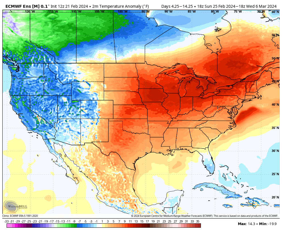
The warmth will be further exacerbated by an amplifying pattern in the mid and upper levels of the atmosphere. Most ensemble guidance shows this quite well, with a deep trough forming in the Western United States and ridging amplifying in the Eastern United States. South and westerly wind flow will encourage warmer than normal air to advect towards our region.
As a result, most model guidance suggests that temperatures will average much warmer than normal from late February into early March. The first weekend of March in particular could be quite warm with temperatures 10-15 degrees (perhaps more) warmer than normal. Needless to say, there will be a few days within this pattern that will have us feeling like spring is finally here.
Not so fast.
Looking under the hood, there are changes occurring aloft that suggest the caution flags should be raised. The stratospheric polar vortex – which is the constantly existing vortex tens of thousands of feet above our heads – is weakening considerably in what may be its last gasp for the season. As this occurs, high-latitude blocking may develop in mid-March (pictured by oranges and yellows in the higher latitudes on the below image).

Ensemble guidance is already hinting at this. As we have discussed several times this year, when blocking high pressures develop over Greenland and Canada, they can displace cold air southward towards our area. Accordingly, there are hints of a colder pattern shift in mid-March that could keep winter weather on the table for at least a few more weeks.
For now, there are no immediate storm threats signaled and major cold isn’t expected. But given what we see in the long-range, it appears that this upcoming warmth could be just another fake spring.
We will see!
I truly enjoy looking through on this site, it has got wonderful articles.
Hi there would you mind sharing which blog platform you’re using? I’m planning to start my own blog soon but I’m having a difficult time selecting between BlogEngine/Wordpress/B2evolution and Drupal. The reason I ask is because your design and style seems different then most blogs and I’m looking for something completely unique. P.S Apologies for being off-topic but I had to ask!
Hi, Neat post. There is an issue together with your web site in internet explorer, might check thisK IE nonetheless is the market leader and a huge element of people will leave out your wonderful writing due to this problem.
I believe this web site contains very great indited subject material articles.
Hello! I’ve been following your blog for a long time now and finally got the courage to go ahead and give you a shout out from Atascocita Texas! Just wanted to say keep up the good job!
I like the valuable information you provide in your articles. I will bookmark your blog and check again here frequently. I am quite certain I will learn a lot of new stuff right here! Best of luck for the next!
But wanna remark on few general things, The website design and style is perfect, the articles is real good : D.
I like this post, enjoyed this one appreciate it for posting. “Abortion is advocated only by persons who have themselves been born.” by Ronald Reagan.
Hi, Neat post. There is an issue with your web site in internet explorer, may test thisK IE nonetheless is the market chief and a good portion of other folks will miss your fantastic writing due to this problem.
I’ve read a few just right stuff here. Certainly price bookmarking for revisiting. I surprise how so much effort you set to make any such magnificent informative website.
I think this website has some real wonderful information for everyone. “As we grow oldthe beauty steals inward.” by Ralph Waldo Emerson.
Just want to say your article is as amazing. The clarity in your post is simply great and i could assume you’re an expert on this subject. Well with your permission allow me to grab your feed to keep up to date with forthcoming post. Thanks a million and please keep up the rewarding work.
Great weblog here! Also your site quite a bit up fast! What host are you using? Can I get your associate link for your host? I desire my web site loaded up as fast as yours lol
Its wonderful as your other blog posts : D, thankyou for putting up. “As experience widens, one begins to see how much upon a level all human things are.” by Joseph Farrell.
Some genuinely interesting details you have written.Helped me a lot, just what I was looking for :D.
I am not rattling wonderful with English but I get hold this real easygoing to understand.
Hi, i think that i saw you visited my site so i came to “return the favor”.I’m attempting to find things to enhance my web site!I suppose its ok to use some of your ideas!!
Great post. I am facing a couple of these problems.
My brother recommended I might like this web site. He was totally right. This post actually made my day. You cann’t imagine just how much time I had spent for this info! Thanks!
I went over this internet site and I believe you have a lot of excellent info, saved to my bookmarks (:.
I’ve recently started a site, the information you provide on this web site has helped me greatly. Thanks for all of your time & work.
Hey There. I discovered your blog the usage of msn. That is an extremely neatly written article. I’ll be sure to bookmark it and come back to read more of your helpful information. Thank you for the post. I’ll definitely comeback.
I always was interested in this topic and still am, thanks for posting.
Yeah bookmaking this wasn’t a risky conclusion great post! .
When I initially commented I clicked the -Notify me when new comments are added- checkbox and now each time a comment is added I get 4 emails with the same comment. Is there any approach you can remove me from that service? Thanks!
Nice read, I just passed this onto a friend who was doing a little research on that. And he actually bought me lunch because I found it for him smile Therefore let me rephrase that: Thank you for lunch! “Bill Dickey is learning me his experience.” by Lawrence Peter Berra.
Perfect piece of work you have done, this website is really cool with excellent information.
What i don’t understood is in fact how you’re not actually much more neatly-preferred than you may be right now. You’re so intelligent. You realize therefore significantly when it comes to this subject, produced me for my part imagine it from numerous various angles. Its like women and men aren’t fascinated except it’s something to accomplish with Woman gaga! Your own stuffs outstanding. Always care for it up!
Thankyou for this marvellous post, I am glad I noticed this site on yahoo.
Hmm it looks like your site ate my first comment (it was super long) so I guess I’ll just sum it up what I submitted and say, I’m thoroughly enjoying your blog. I too am an aspiring blog writer but I’m still new to everything. Do you have any suggestions for inexperienced blog writers? I’d really appreciate it.
I’m commenting to make you be aware of of the perfect encounter my princess enjoyed going through your webblog. She came to find such a lot of things, which include what it is like to have a great teaching spirit to have men and women just learn certain extremely tough matters. You undoubtedly did more than her expectations. Many thanks for producing the great, trusted, revealing not to mention easy guidance on your topic to Kate.
Oh my goodness! a tremendous article dude. Thanks Nonetheless I’m experiencing situation with ur rss . Don’t know why Unable to subscribe to it. Is there anybody getting similar rss drawback? Anyone who is aware of kindly respond. Thnkx
What’s Happening i’m new to this, I stumbled upon this I have found It positively helpful and it has aided me out loads. I am hoping to contribute & aid other users like its aided me. Good job.
Hello. excellent job. I did not anticipate this. This is a impressive story. Thanks!
This blog is definitely rather handy since I’m at the moment creating an internet floral website – although I am only starting out therefore it’s really fairly small, nothing like this site. Can link to a few of the posts here as they are quite. Thanks much. Zoey Olsen
Wonderful work! This is the type of information that should be shared around the web. Shame on the search engines for not positioning this post higher! Come on over and visit my site . Thanks =)
naturally like your web-site but you have to test the spelling on quite a few of your posts. Many of them are rife with spelling issues and I in finding it very bothersome to inform the truth on the other hand I will certainly come back again.
Helpful information. Lucky me I found your site accidentally, and I am surprised why this accident did not happened earlier! I bookmarked it.
You are my inspiration , I possess few web logs and sometimes run out from to brand.
Generally I don’t read article on blogs, but I would like to say that this write-up very forced me to try and do it! Your writing style has been amazed me. Thanks, quite nice post.
Wonderful work! This is the type of information that should be shared around the net. Shame on the search engines for not positioning this post higher! Come on over and visit my site . Thanks =)
I am often to blogging and i really appreciate your content. The article has really peaks my interest. I am going to bookmark your site and keep checking for new information.
I was studying some of your content on this website and I conceive this web site is real instructive! Keep putting up.
I discovered your blog site on google and check a few of your early posts. Continue to keep up the very good operate. I just additional up your RSS feed to my MSN News Reader. Seeking forward to reading more from you later on!…
Thanks for the sensible critique. Me & my neighbor were just preparing to do some research on this. We got a grab a book from our area library but I think I learned more clear from this post. I’m very glad to see such magnificent information being shared freely out there.
I’m no longer sure the place you are getting your info, but good topic. I must spend a while finding out much more or working out more. Thank you for magnificent information I was in search of this information for my mission.
I’ve been absent for a while, but now I remember why I used to love this website. Thank you, I will try and check back more frequently. How frequently you update your site?
As soon as I detected this website I went on reddit to share some of the love with them.
I got what you mean , appreciate it for putting up.Woh I am glad to find this website through google.
Some genuinely good content on this site, appreciate it for contribution. “My salad days, When I was green in judgment.” by William Shakespeare.
We are a gaggle of volunteers and opening a new scheme in our community. Your web site offered us with valuable information to work on. You’ve performed an impressive task and our whole neighborhood will likely be grateful to you.
I simply wished to appreciate you once again. I’m not certain what I could possibly have followed in the absence of the solutions revealed by you directly on such a subject. It previously was a very hard dilemma in my circumstances, but taking a look at a skilled approach you handled that forced me to cry for delight. Extremely happy for the information and in addition trust you know what a great job that you are accomplishing instructing others thru a web site. I am certain you have never encountered any of us.
This is the right blog for anyone who wants to find out about this topic. You realize so much its almost hard to argue with you (not that I actually would want…HaHa). You definitely put a new spin on a topic thats been written about for years. Great stuff, just great!
We’re a group of volunteers and starting a new scheme in our community. Your site offered us with valuable information to work on. You have done an impressive job and our whole community will be grateful to you.
Absolutely pent subject matter, Really enjoyed reading through.
What i do not realize is in fact how you are not actually much more well-liked than you may be now. You’re very intelligent. You already know thus considerably in the case of this topic, produced me in my opinion consider it from numerous various angles. Its like men and women are not involved except it’s something to accomplish with Girl gaga! Your individual stuffs outstanding. Always maintain it up!
Thanks a bunch for sharing this with all of us you really know what you’re talking about! Bookmarked. Kindly also visit my site =). We could have a link exchange agreement between us!
Pretty nice post. I just stumbled upon your blog and wanted to say that I have truly enjoyed browsing your blog posts. After all I’ll be subscribing to your rss feed and I hope you write again soon!
You have brought up a very great details, thankyou for the post.
Nice read, I just passed this onto a colleague who was doing a little research on that. And he just bought me lunch since I found it for him smile Therefore let me rephrase that: Thanks for lunch! “Curiosity will conquer fear even more than bravery will.” by James Stephens.
Write more, thats all I have to say. Literally, it seems as though you relied on the video to make your point. You clearly know what youre talking about, why throw away your intelligence on just posting videos to your blog when you could be giving us something informative to read?
I was very happy to find this net-site.I wanted to thanks on your time for this wonderful read!! I definitely having fun with each little little bit of it and I’ve you bookmarked to take a look at new stuff you blog post.
Thanks for sharing superb informations. Your site is so cool. I am impressed by the details that you’ve on this website. It reveals how nicely you perceive this subject. Bookmarked this web page, will come back for extra articles. You, my friend, ROCK! I found simply the info I already searched everywhere and just could not come across. What a perfect site.
When I originally commented I clicked the -Notify me when new comments are added- checkbox and now each time a comment is added I get four emails with the same comment. Is there any way you can remove me from that service? Thanks!
Amazing! This blog looks just like my old one! It’s on a totally different topic but it has pretty much the same layout and design. Outstanding choice of colors!
Magnificent site. Lots of useful information here. I am sending it to several friends ans also sharing in delicious. And of course, thanks for your effort!
Thanks for this grand post, I am glad I discovered this internet site on yahoo.
Hello would you mind letting me know which webhost you’re utilizing? I’ve loaded your blog in 3 different web browsers and I must say this blog loads a lot quicker then most. Can you suggest a good internet hosting provider at a reasonable price? Kudos, I appreciate it!
Wow! Thank you! I permanently wanted to write on my site something like that. Can I take a part of your post to my blog?
There may be noticeably a bundle to learn about this. I assume you made sure nice factors in options also.
Awsome website! I am loving it!! Will come back again. I am bookmarking your feeds also.
Nice post. I was checking continuously this blog and I am impressed! Extremely useful information particularly the last part 🙂 I care for such info much. I was seeking this certain info for a long time. Thank you and good luck.
Hello! I just wanted to ask if you ever have any problems with hackers? My last blog (wordpress) was hacked and I ended up losing several weeks of hard work due to no back up. Do you have any methods to stop hackers?
Really wonderful visual appeal on this web site, I’d rate it 10 10.
Hey there, You’ve done an excellent job. I will certainly digg it and in my view suggest to my friends. I’m confident they will be benefited from this website.
Wow! This can be one particular of the most useful blogs We have ever arrive across on this subject. Actually Excellent. I’m also an expert in this topic therefore I can understand your effort.
I’m impressed, I must say. Really hardly ever do I encounter a blog that’s both educative and entertaining, and let me tell you, you could have hit the nail on the head. Your thought is outstanding; the problem is something that not enough persons are speaking intelligently about. I’m very comfortable that I stumbled across this in my search for one thing relating to this.
My brother suggested I might like this web site. He was totally right. This post truly made my day. You can not imagine just how much time I had spent for this information! Thanks!
Hello, i think that i saw you visited my website thus i came to “return the favor”.I’m attempting to find things to enhance my web site!I suppose its ok to use some of your ideas!!
Hi , I do believe this is an excellent blog. I stumbled upon it on Yahoo , i will come back once again. Money and freedom is the best way to change, may you be rich and help other people.
Normally I don’t read post on blogs, but I wish to say that this write-up very forced me to try and do so! Your writing style has been amazed me. Thanks, quite nice article.
Good day! This post could not be written any better! Reading this post reminds me of my previous room mate! He always kept talking about this. I will forward this page to him. Fairly certain he will have a good read. Many thanks for sharing!
You are a very bright person!
Today, I went to the beach front with my kids. I found a sea shell and gave it to my 4 year old daughter and said “You can hear the ocean if you put this to your ear.” She placed the shell to her ear and screamed. There was a hermit crab inside and it pinched her ear. She never wants to go back! LoL I know this is totally off topic but I had to tell someone!
I got what you mean , appreciate it for posting.Woh I am lucky to find this website through google.
This is really interesting, You’re a very skilled blogger. I have joined your feed and look forward to seeking more of your wonderful post. Also, I’ve shared your site in my social networks!
Great website. A lot of useful information here. I am sending it to several friends ans also sharing in delicious. And obviously, thanks for your sweat!
I really appreciate this post. I’ve been looking all over for this! Thank goodness I found it on Bing. You have made my day! Thx again
This is really interesting, You are a very skilled blogger. I have joined your feed and look forward to seeking more of your great post. Also, I have shared your web site in my social networks!
Only a smiling visitant here to share the love (:, btw great design and style. “Better by far you should forget and smile than that you should remember and be sad.” by Christina Georgina Rossetti.
Hello would you mind letting me know which hosting company you’re utilizing? I’ve loaded your blog in 3 completely different browsers and I must say this blog loads a lot quicker then most. Can you suggest a good internet hosting provider at a honest price? Cheers, I appreciate it!
fantastic points altogether, you just gained a new reader. What would you recommend in regards to your post that you made a few days ago? Any positive?
I absolutely love your blog and find nearly all of your post’s to be precisely what I’m looking for. can you offer guest writers to write content for you? I wouldn’t mind publishing a post or elaborating on most of the subjects you write about here. Again, awesome web log!
Greetings from Carolina! I’m bored to death at work so I decided to check out your site on my iphone during lunch break. I really like the information you present here and can’t wait to take a look when I get home. I’m amazed at how quick your blog loaded on my cell phone .. I’m not even using WIFI, just 3G .. Anyways, fantastic blog!
Hello there, I found your web site via Google while looking for a related topic, your website came up, it looks great. I have bookmarked it in my google bookmarks.
I reckon something truly special in this internet site.
Hey there! This is my 1st comment here so I just wanted to give a quick shout out and tell you I genuinely enjoy reading through your articles. Can you suggest any other blogs/websites/forums that cover the same topics? Thank you so much!
I have recently started a website, the information you offer on this site has helped me greatly. Thanks for all of your time & work.
I am no longer sure the place you are getting your information, however great topic. I needs to spend a while learning more or working out more. Thank you for great information I used to be on the lookout for this info for my mission.
Keep up the fantastic piece of work, I read few content on this web site and I believe that your web blog is very interesting and has lots of fantastic information.
I genuinely treasure your piece of work, Great post.
You made some decent points there. I did a search on the topic and found most persons will go along with with your blog.
Hey! This is kind of off topic but I need some advice from an established blog. Is it hard to set up your own blog? I’m not very techincal but I can figure things out pretty fast. I’m thinking about setting up my own but I’m not sure where to start. Do you have any tips or suggestions? With thanks
superb post.Ne’er knew this, thankyou for letting me know.
I like this website because so much useful stuff on here :D.
When I initially commented I clicked the “Notify me when new comments are added” checkbox and now each time a comment is added I get three e-mails with the same comment. Is there any way you can remove people from that service? Thanks!
I would like to thnkx for the efforts you have put in writing this website. I am hoping the same high-grade blog post from you in the upcoming also. In fact your creative writing skills has inspired me to get my own site now. Really the blogging is spreading its wings fast. Your write up is a great example of it.
I believe this web site contains very wonderful pent written content blog posts.
I simply needed to appreciate you all over again. I am not sure the things I could possibly have tried without those methods provided by you concerning this theme. Entirely was an absolute distressing crisis in my opinion, however , encountering this specialized style you dealt with it took me to weep with happiness. I am thankful for the support and then trust you find out what an amazing job you were providing educating some other people all through your blog post. Most likely you have never got to know any of us.
Heya i’m for the first time here. I came across this board and I find It truly useful & it helped me out a lot. I hope to give something back and help others like you helped me.
Very interesting subject , regards for putting up.
I am really enjoying the theme/design of your website. Do you ever run into any web browser compatibility issues? A couple of my blog readers have complained about my blog not operating correctly in Explorer but looks great in Opera. Do you have any tips to help fix this issue?
you have a great blog here! would you like to make some invite posts on my blog?
Lovely blog! I am loving it!! Will come back again. I am bookmarking your feeds also.
I like what you guys are up too. Such clever work and reporting! Carry on the superb works guys I have incorporated you guys to my blogroll. I think it will improve the value of my website 🙂
급하게 현금이 필요한 순간, 소액결제 현금화를 안전하게 이용하는 방법을 안내합니다. 실제 이용 기준으로 수수료, 절차, 주의사항까지 빠르게 확인하세요.
Thanks , I have recently been searching for info about this subject for ages and yours is the greatest I’ve discovered so far. But, what about the bottom line? Are you sure about the source?
I was just searching for this info for a while. After six hours of continuous Googleing, at last I got it in your site. I wonder what is the lack of Google strategy that do not rank this type of informative sites in top of the list. Generally the top sites are full of garbage.
I really appreciate this post. I’ve been looking all over for this! Thank goodness I found it on Bing. You’ve made my day! Thx again
This blog is definitely rather handy since I’m at the moment creating an internet floral website – although I am only starting out therefore it’s really fairly small, nothing like this site. Can link to a few of the posts here as they are quite. Thanks much. Zoey Olsen
Thanks for any other informative website. The place else could I am getting that type of information written in such an ideal approach? I have a undertaking that I’m simply now running on, and I have been on the glance out for such info.
I have learn several good stuff here. Certainly worth bookmarking for revisiting. I surprise how a lot effort you place to make such a fantastic informative website.
Hiya very cool web site!! Man .. Excellent .. Wonderful .. I will bookmark your website and take the feeds additionally…I’m happy to seek out so many useful info right here in the put up, we need work out extra strategies in this regard, thank you for sharing. . . . . .
Can I simply say what a reduction to find somebody who actually is aware of what theyre speaking about on the internet. You undoubtedly know the way to convey a problem to mild and make it important. Extra people need to learn this and perceive this facet of the story. I cant consider youre not more popular since you undoubtedly have the gift.
I have been checking out many of your articles and i must say clever stuff. I will make sure to bookmark your site.
Enjoyed looking through this, very good stuff, regards.
Thanks – Enjoyed this article, how can I make is so that I receive an email sent to me when you publish a new update?
An interesting discussion is worth comment. I think that you should write more on this topic, it might not be a taboo subject but generally people are not enough to speak on such topics. To the next. Cheers
I want foregathering useful info, this post has got me even more info! .
I was very pleased to find this web-site.I wanted to thanks for your time for this wonderful read!! I definitely enjoying every little bit of it and I have you bookmarked to check out new stuff you blog post.
Valuable info. Lucky me I found your website by accident, and I’m shocked why this accident did not happened earlier! I bookmarked it.
Dead composed subject matter, Really enjoyed looking at.
Wish you happiness
Hi, Neat post. There is an issue along with your website in internet explorer, may check thisK IE nonetheless is the marketplace chief and a good part of folks will pass over your fantastic writing due to this problem.
You have mentioned very interesting details ! ps decent website .
Hiya, I am really glad I have found this info. Nowadays bloggers publish just about gossips and internet and this is really frustrating. A good site with interesting content, this is what I need. Thank you for keeping this web-site, I’ll be visiting it. Do you do newsletters? Cant find it.
Keep working ,terrific job!
I have recently started a website, the information you provide on this web site has helped me tremendously. Thanks for all of your time & work.
I appreciate, cause I found just what I was looking for. You’ve ended my four day long hunt! God Bless you man. Have a nice day. Bye
Sweet site, super layout, rattling clean and employ friendly.
I really appreciate this post. I’ve been looking all over for this! Thank goodness I found it on Bing. You’ve made my day! Thx again
I don’t even know how I ended up here, but I thought this post was good. I do not know who you are but certainly you are going to a famous blogger if you are not already 😉 Cheers!
Once I initially commented I clicked the -Notify me when new comments are added- checkbox and now every time a comment is added I get 4 emails with the identical comment. Is there any manner you possibly can remove me from that service? Thanks!
I was reading through some of your articles on this website and I think this site is real instructive! Continue putting up.
You made some nice points there. I did a search on the subject and found most people will agree with your blog.
You have brought up a very great details, thankyou for the post.
Hello, Neat post. There is a problem together with your site in web explorer, could test thisK IE still is the marketplace leader and a big part of other people will leave out your excellent writing due to this problem.
Thanks – Enjoyed this blog post, is there any way I can receive an email whenever you write a fresh post?
I needed to put you one tiny note just to thank you so much as before for your lovely knowledge you have shown in this article. It was simply surprisingly open-handed of people like you to grant easily exactly what a number of us would’ve distributed as an electronic book to get some dough for themselves, notably given that you might well have tried it in case you considered necessary. The good tips in addition acted to become good way to be aware that the rest have the same fervor just as mine to realize more and more on the topic of this matter. I’m sure there are millions of more pleasant opportunities up front for people who look into your site.
You are my intake, I have few blogs and often run out from to post : (.
I like this website so much, saved to favorites.
Thankyou for all your efforts that you have put in this. very interesting information.
I really like your writing style, great info, regards for posting :D. “Let every man mind his own business.” by Miguel de Cervantes.
Just wanna comment on few general things, The website layout is perfect, the articles is very superb. “The stars are constantly shining, but often we do not see them until the dark hours.” by Earl Riney.
Some genuinely quality articles on this web site, saved to my bookmarks.
I enjoy, result in I discovered exactly what I was looking for. You have ended my four day lengthy hunt! God Bless you man. Have a great day. Bye
Enjoyed studying this, very good stuff, thankyou.
Very interesting information!Perfect just what I was searching for!
Undeniably believe that which you said. Your favorite reason seemed to be on the web the easiest factor to keep in mind of. I say to you, I certainly get irked at the same time as people consider concerns that they just do not realize about. You managed to hit the nail upon the highest and also outlined out the whole thing without having side effect , people could take a signal. Will probably be again to get more. Thank you
You have mentioned very interesting points! ps decent website .
Greetings from Idaho! I’m bored to tears at work so I decided to check out your site on my iphone during lunch break. I love the info you provide here and can’t wait to take a look when I get home. I’m shocked at how fast your blog loaded on my phone .. I’m not even using WIFI, just 3G .. Anyways, very good blog!
Have you ever considered creating an ebook or guest authoring on other blogs? I have a blog centered on the same ideas you discuss and would really like to have you share some stories/information. I know my visitors would enjoy your work. If you’re even remotely interested, feel free to shoot me an e mail.
I got what you intend, thanks for putting up.Woh I am thankful to find this website through google.
hello there and thank you on your information – I have certainly picked up something new from right here. I did alternatively expertise some technical issues the use of this website, as I experienced to reload the site lots of occasions previous to I may get it to load properly. I had been puzzling over in case your web host is OK? Not that I’m complaining, however slow loading instances occasions will often affect your placement in google and could damage your quality rating if ads and ***********|advertising|advertising|advertising and *********** with Adwords. Anyway I am including this RSS to my email and could look out for much more of your respective exciting content. Make sure you update this once more very soon..
When I initially commented I clicked the “Notify me when new comments are added” checkbox and now each time a comment is added I get several e-mails with the same comment. Is there any way you can remove me from that service? Many thanks!
I will immediately seize your rss feed as I can not to find your e-mail subscription link or e-newsletter service. Do you’ve any? Please allow me understand so that I may just subscribe. Thanks.
What i do not understood is actually how you are no longer really much more smartly-favored than you might be now. You are very intelligent. You already know thus considerably in the case of this topic, produced me in my view imagine it from a lot of various angles. Its like women and men are not involved until it is one thing to do with Girl gaga! Your own stuffs excellent. At all times care for it up!
Perfectly composed subject material, regards for selective information.
Hello there, I discovered your site by means of Google even as looking for a similar matter, your website came up, it appears good. I’ve bookmarked it in my google bookmarks.
you are really a good webmaster. The website loading speed is incredible. It seems that you are doing any unique trick. Furthermore, The contents are masterwork. you have done a excellent job on this topic!
I’m not certain the place you are getting your information, however great topic. I needs to spend some time finding out more or working out more. Thanks for magnificent information I was searching for this info for my mission.
I’d should verify with you here. Which isn’t one thing I normally do! I get pleasure from studying a publish that may make people think. Also, thanks for allowing me to comment!
You made some fine points there. I did a search on the issue and found most folks will go along with with your blog.
This blog is definitely rather handy since I’m at the moment creating an internet floral website – although I am only starting out therefore it’s really fairly small, nothing like this site. Can link to a few of the posts here as they are quite. Thanks much. Zoey Olsen
After all, what a great site and informative posts, I will upload inbound link – bookmark this web site? Regards, Reader.
It’s hard to find knowledgeable people on this topic, but you sound like you know what you’re talking about! Thanks
Hi are using WordPress for your site platform? I’m new to the blog world but I’m trying to get started and create my own. Do you need any coding expertise to make your own blog? Any help would be greatly appreciated!
I was looking at some of your posts on this site and I think this site is real informative! Keep putting up.
After all, what a great site and informative posts, I will upload inbound link – bookmark this web site? Regards, Reader.
Hey very cool site!! Guy .. Beautiful .. Wonderful .. I will bookmark your blog and take the feeds additionally…I’m glad to find numerous helpful information right here within the submit, we need work out more strategies on this regard, thanks for sharing.
As a Newbie, I am continuously exploring online for articles that can help me. Thank you
Its excellent as your other blog posts : D, thankyou for putting up. “Slump I ain’t in no slump… I just ain’t hitting.” by Yogi Berra.
I enjoy your piece of work, appreciate it for all the informative articles.
It’s actually a great and useful piece of info. I’m happy that you just shared this helpful information with us. Please stay us up to date like this. Thank you for sharing.
Very interesting info !Perfect just what I was looking for! “People everywhere confuse what they read in newspapers with news.” by A. J. Liebling.
Incredible! This blog looks exactly like my old one! It’s on a totally different subject but it has pretty much the same layout and design. Excellent choice of colors!
I really like your writing style, wonderful information, appreciate it for posting :D. “Faith is a continuation of reason.” by William Adams.
I loved as much as you will receive carried out right here. The sketch is tasteful, your authored material stylish. nonetheless, you command get got an shakiness over that you wish be delivering the following. unwell unquestionably come more formerly again since exactly the same nearly very often inside case you shield this increase.
Excellent read, I just passed this onto a friend who was doing a little research on that. And he actually bought me lunch since I found it for him smile So let me rephrase that: Thanks for lunch! “We steal if we touch tomorrow. It is God’s.” by Henry Ward Beecher.
I together with my pals were actually examining the great tips and tricks on the website while then I got a terrible suspicion I never thanked the website owner for them. All of the guys are already as a consequence excited to read all of them and now have without a doubt been taking pleasure in them. Thank you for being considerably accommodating and also for having this form of amazing subject matter most people are really needing to be aware of. Our own honest apologies for not expressing gratitude to you sooner.
Aw, this was a very nice post. In concept I want to put in writing like this additionally – taking time and actual effort to make a very good article… however what can I say… I procrastinate alot and not at all seem to get something done.
Whats up very nice website!! Man .. Excellent .. Superb .. I’ll bookmark your website and take the feeds additionally…I am satisfied to seek out so many helpful info here in the post, we want work out extra techniques in this regard, thanks for sharing.
My brother suggested I may like this blog. He used to be entirely right. This submit truly made my day. You can not imagine just how a lot time I had spent for this info! Thank you!
I have been absent for some time, but now I remember why I used to love this website. Thanks , I’ll try and check back more frequently. How frequently you update your site?
There’s noticeably a bundle to learn about this. I assume you made certain good factors in options also.
Nice post. I learn something more challenging on different blogs everyday. It will always be stimulating to read content from other writers and practice a little something from their store. I’d prefer to use some with the content on my blog whether you don’t mind. Natually I’ll give you a link on your web blog. Thanks for sharing.
That is the precise weblog for anybody who wants to search out out about this topic. You understand a lot its nearly exhausting to argue with you (not that I really would need…HaHa). You positively put a new spin on a topic thats been written about for years. Nice stuff, just great!
Pretty component of content. I simply stumbled upon your blog and in accession capital to claim that I acquire actually loved account your weblog posts. Anyway I will be subscribing on your feeds and even I achievement you get admission to constantly rapidly.
My coder is trying to convince me to move to .net from PHP. I have always disliked the idea because of the expenses. But he’s tryiong none the less. I’ve been using WordPress on a number of websites for about a year and am concerned about switching to another platform. I have heard excellent things about blogengine.net. Is there a way I can transfer all my wordpress posts into it? Any kind of help would be really appreciated!
I just couldn’t leave your site before suggesting that I actually enjoyed the standard information a person provide to your visitors? Is going to be again ceaselessly in order to check up on new posts.
I like this website very much so much good information.
you’re really a good webmaster. The site loading speed is incredible. It seems that you’re doing any unique trick. In addition, The contents are masterpiece. you’ve done a great job on this topic!
Hello There. I found your blog using msn. This is a very well written article. I’ll make sure to bookmark it and return to read more of your useful info. Thanks for the post. I will definitely comeback.
Great items from you, man. I’ve keep in mind your stuff prior to and you’re simply too excellent. I actually like what you have acquired right here, really like what you are stating and the best way by which you say it. You are making it enjoyable and you continue to take care of to keep it wise. I can’t wait to read much more from you. This is really a terrific web site.
2fvdo4
Everyone loves what you guys are usually up too. This type of clever work and exposure! Keep up the fantastic works guys I’ve included you guys to blogroll.
What’s Happening i am new to this, I stumbled upon this I have found It positively useful and it has helped me out loads. I hope to contribute & aid other users like its aided me. Good job.
Simply desire to say your article is as astonishing. The clarity in your post is simply excellent and i could assume you’re an expert on this subject. Fine with your permission let me to grab your feed to keep up to date with forthcoming post. Thanks a million and please carry on the enjoyable work.
Great beat ! I wish to apprentice while you amend your site, how could i subscribe for a blog website? The account aided me a acceptable deal. I had been a little bit acquainted of this your broadcast provided bright clear concept
Good write-up, I’m normal visitor of one’s web site, maintain up the excellent operate, and It’s going to be a regular visitor for a lengthy time.
Thanx for the effort, keep up the good work Great work, I am going to start a small Blog Engine course work using your site I hope you enjoy blogging with the popular BlogEngine.net.Thethoughts you express are really awesome. Hope you will right some more posts.
Hey very cool web site!! Man .. Beautiful .. Amazing .. I’ll bookmark your blog and take the feeds also…I’m happy to find so many useful information here in the post, we need work out more strategies in this regard, thanks for sharing. . . . . .
Thanks for all your efforts that you have put in this. very interesting information.
I will immediately seize your rss as I can not find your email subscription link or e-newsletter service. Do you have any? Kindly let me realize in order that I could subscribe. Thanks.
Thank you for sharing with us, I conceive this website genuinely stands out :D.
I was just searching for this information for some time. After six hours of continuous Googleing, finally I got it in your website. I wonder what is the lack of Google strategy that do not rank this kind of informative websites in top of the list. Usually the top web sites are full of garbage.
As a Newbie, I am permanently searching online for articles that can help me. Thank you
Really enjoyed this blog post, is there any way I can receive an email sent to me when you write a fresh article?
Hi! This is kind of off topic but I need some advice from an established blog. Is it hard to set up your own blog? I’m not very techincal but I can figure things out pretty fast. I’m thinking about setting up my own but I’m not sure where to begin. Do you have any points or suggestions? Appreciate it
Hi! This post could not be written any better! Reading through this post reminds me of my previous room mate! He always kept chatting about this. I will forward this write-up to him. Pretty sure he will have a good read. Many thanks for sharing!
Good day! Would you mind if I share your blog with my myspace group? There’s a lot of people that I think would really enjoy your content. Please let me know. Cheers
Its like you read my mind! You seem to know a lot about this, like you wrote the book in it or something. I think that you could do with some pics to drive the message home a bit, but instead of that, this is excellent blog. A fantastic read. I’ll certainly be back.
so much fantastic info on here, :D.
Aavant produces the best photography, event and theatre backdrops in the world and works for almost all the biggest players in the world. Being in backdrops industry for last two decades it is the largest player in the world, providing highest quality backdrops to every buyer from USA to Australia.
You got a very fantastic website, Glad I noticed it through yahoo.
It’s really a cool and helpful piece of info. I am glad that you shared this useful information with us. Please keep us up to date like this. Thanks for sharing.
I got what you intend,saved to favorites, very decent internet site.
I have read a few good stuff here. Definitely worth bookmarking for revisiting. I surprise how much effort you put to make such a magnificent informative website.
Attractive section of content. I just stumbled upon your web site and in accession capital to assert that I get actually enjoyed account your blog posts. Any way I will be subscribing to your augment and even I achievement you access consistently rapidly.
Aavant produces the best photography, event and theatre backdrops in the world and works for almost all the biggest players in the world. Being in backdrops industry for last two decades it is the largest player in the world, providing highest quality backdrops to every buyer from USA to Australia.
Aavant produces the best photography, event and theatre backdrops in the world and works for almost all the biggest players in the world. Being in backdrops industry for last two decades it is the largest player in the world, providing highest quality backdrops to every buyer from USA to Australia.
Greetings! This is my first visit to your blog! We are a collection of volunteers and starting a new initiative in a community in the same niche. Your blog provided us beneficial information to work on. You have done a marvellous job!
I keep listening to the reports lecture about receiving boundless online grant applications so I have been looking around for the most excellent site to get one. Could you advise me please, where could i get some?
Aavant produces the best photography, event and theatre backdrops in the world and works for almost all the biggest players in the world. Being in backdrops industry for last two decades it is the largest player in the world, providing highest quality backdrops to every buyer from USA to Australia.
Hey very nice site!! Guy .. Beautiful .. Wonderful .. I’ll bookmark your site and take the feeds additionally…I am glad to seek out a lot of useful info right here in the put up, we want develop extra strategies on this regard, thank you for sharing. . . . . .
Hiya very nice site!! Man .. Beautiful .. Wonderful .. I will bookmark your blog and take the feeds also…I’m glad to seek out so many helpful info here within the publish, we’d like develop more strategies in this regard, thank you for sharing. . . . . .
Sweet website , super style and design, real clean and apply friendly.
Very good information can be found on web site.
Utterly indited content, Really enjoyed reading.
I’ve been exploring for a bit for any high quality articles or weblog posts on this sort of area . Exploring in Yahoo I finally stumbled upon this site. Studying this information So i’m happy to convey that I have a very good uncanny feeling I found out just what I needed. I so much unquestionably will make sure to do not disregard this web site and provides it a look regularly.
hello!,I like your writing so much! share we communicate more about your post on AOL? I require a specialist on this area to solve my problem. May be that’s you! Looking forward to see you.
Great beat ! I wish to apprentice while you amend your site, how can i subscribe for a blog web site? The account helped me a acceptable deal. I had been tiny bit acquainted of this your broadcast offered bright clear concept
You are my breathing in, I possess few web logs and occasionally run out from post :). “The soul that is within me no man can degrade.” by Frederick Douglas.
Good post. I be taught something more challenging on different blogs everyday. It will all the time be stimulating to learn content material from other writers and practice somewhat one thing from their store. I’d want to use some with the content material on my weblog whether you don’t mind. Natually I’ll provide you with a link in your web blog. Thanks for sharing.
You have remarked very interesting details ! ps decent website .
Some genuinely nice stuff on this web site, I like it.
Hi my friend! I wish to say that this post is amazing, nice written and include almost all significant infos. I would like to see more posts like this.
Thanks for the sensible critique. Me & my neighbor were just preparing to do a little research on this. We got a grab a book from our area library but I think I learned more from this post. I’m very glad to see such excellent info being shared freely out there.
It’s arduous to seek out educated folks on this matter, but you sound like you understand what you’re speaking about! Thanks
Only wanna admit that this is very helpful, Thanks for taking your time to write this.
Very interesting information!Perfect just what I was searching for!
Thanks for the sensible critique. Me & my neighbor were just preparing to do some research about this. We got a grab a book from our area library but I think I learned more clear from this post. I am very glad to see such excellent info being shared freely out there.
I’ve learn some just right stuff here. Certainly worth bookmarking for revisiting. I wonder how so much attempt you put to make this type of excellent informative website.
It’s a pity you don’t have a donate button! I’d certainly donate to this fantastic blog! I guess for now i’ll settle for bookmarking and adding your RSS feed to my Google account. I look forward to fresh updates and will share this website with my Facebook group. Talk soon!
Loving the info on this web site, you have done outstanding job on the articles.
I envy your piece of work, thanks for all the good content.
you are really a excellent webmaster. The site loading velocity is amazing. It kind of feels that you’re doing any unique trick. Also, The contents are masterpiece. you’ve performed a wonderful activity on this topic!
Excellent post. I used to be checking constantly this weblog and I’m inspired! Very useful info particularly the closing section 🙂 I care for such info much. I used to be looking for this certain information for a long time. Thanks and best of luck.
I went over this site and I conceive you have a lot of good info, saved to my bookmarks (:.
Hello, you used to write great, but the last several posts have been kinda boring… I miss your super writings. Past several posts are just a little out of track! come on!
My wife and i got cheerful when Edward managed to carry out his analysis via the ideas he discovered out of your web page. It’s not at all simplistic just to always be giving for free tricks that most people could have been selling. And we also figure out we need you to give thanks to for that. These illustrations you have made, the straightforward blog menu, the relationships your site assist to promote – it is all extraordinary, and it’s really aiding our son in addition to the family know that that topic is enjoyable, which is certainly highly mandatory. Thank you for the whole thing!
Thanks for sharing excellent informations. Your website is very cool. I’m impressed by the details that you have on this website. It reveals how nicely you understand this subject. Bookmarked this website page, will come back for extra articles. You, my friend, ROCK! I found simply the info I already searched all over the place and simply could not come across. What a great website.
Deference to article author, some superb information .
I believe that is one of the so much important information for me. And i am happy reading your article. However wanna remark on some normal things, The web site taste is ideal, the articles is truly great :D. Excellent task, cheers
Would love to always get updated great blog! .
I conceive you have mentioned some very interesting details , regards for the post.
I conceive you have remarked some very interesting details, appreciate it for the post.
I have been exploring for a little for any high-quality articles or blog posts on this sort of space . Exploring in Yahoo I eventually stumbled upon this website. Studying this information So i’m satisfied to show that I have an incredibly excellent uncanny feeling I found out just what I needed. I so much for sure will make sure to don’t omit this website and provides it a glance regularly.
I genuinely enjoy looking through on this web site, it holds great content.
You are my breathing in, I possess few web logs and often run out from to brand : (.
Hi there! This post couldn’t be written any better! Reading through this post reminds me of my previous room mate! He always kept talking about this. I will forward this article to him. Pretty sure he will have a good read. Thank you for sharing!
I really like your writing style, wonderful information, thank you for posting :D. “I will show you fear in a handful of dust.” by T. S. Eliot.
You have brought up a very wonderful points, appreciate it for the post.
Some really nice and utilitarian information on this website, as well I think the style holds great features.
Utterly composed articles, Really enjoyed looking through.
Some really excellent articles on this web site, thanks for contribution.
Wonderful blog! I found it while surfing around on Yahoo News. Do you have any tips on how to get listed in Yahoo News? I’ve been trying for a while but I never seem to get there! Cheers
Dead written subject material, Really enjoyed reading through.
At this time it looks like Drupal is the top blogging platform available right now. (from what I’ve read) Is that what you’re using on your blog?
Oh my goodness! a tremendous article dude. Thank you However I’m experiencing challenge with ur rss . Don’t know why Unable to subscribe to it. Is there anybody getting equivalent rss downside? Anybody who knows kindly respond. Thnkx
I’m really enjoying the theme/design of your site. Do you ever run into any browser compatibility issues? A handful of my blog visitors have complained about my blog not working correctly in Explorer but looks great in Chrome. Do you have any ideas to help fix this issue?
türk kahvesinin faydaları
Hello my friend! I want to say that this post is amazing, nice written and include approximately all vital infos. I would like to see more posts like this.
I love your blog.. very nice colors & theme. Did you create this website yourself or did you hire someone to do it for you? Plz answer back as I’m looking to design my own blog and would like to find out where u got this from. thank you
I have been surfing on-line more than 3 hours today, yet I by no means discovered any fascinating article like yours. It’s beautiful worth sufficient for me. In my opinion, if all website owners and bloggers made just right content as you did, the net can be much more helpful than ever before. “Where facts are few, experts are many.” by Donald R. Gannon.
Heya i am for the first time here. I came across this board and I find It really useful & it helped me out much. I hope to give something back and help others like you aided me.
You have mentioned very interesting details ! ps decent site.
Hey There. I found your blog using msn. This is an extremely well written article. I’ll make sure to bookmark it and come back to read more of your useful info. Thanks for the post. I’ll certainly return.
Thanks , I have recently been looking for information about this topic for ages and yours is the greatest I have discovered till now. But, what about the bottom line? Are you sure about the source?
I found your blog site on google and check just a few of your early posts. Continue to keep up the very good operate. I just further up your RSS feed to my MSN Information Reader. Seeking ahead to reading more from you later on!…
I was studying some of your blog posts on this internet site and I believe this web site is rattling informative ! Retain putting up.
I do consider all the ideas you have introduced on your post. They’re very convincing and can definitely work. Still, the posts are too short for starters. May just you please extend them a little from next time? Thanks for the post.
you’ve a terrific weblog right here! would you prefer to make some invite posts on my weblog?
I conceive this website has got very superb written articles articles.
I definitely wanted to compose a remark so as to thank you for these superb advice you are writing on this website. My extended internet investigation has now been paid with excellent knowledge to exchange with my neighbours. I would suppose that most of us readers actually are definitely lucky to be in a great community with very many lovely people with interesting principles. I feel very blessed to have encountered your webpages and look forward to so many more excellent minutes reading here. Thanks once more for everything.
Thankyou for this post, I am a big fan of this website would like to go along updated.
You made certain good points there. I did a search on the subject and found the majority of folks will have the same opinion with your blog.
It’s actually a great and useful piece of info. I’m happy that you simply shared this useful info with us. Please stay us informed like this. Thanks for sharing.
Some really nice and useful info on this internet site, too I think the style contains excellent features.
I was just looking for this information for a while. After 6 hours of continuous Googleing, finally I got it in your web site. I wonder what’s the lack of Google strategy that don’t rank this kind of informative websites in top of the list. Usually the top web sites are full of garbage.
It’s hard to find knowledgeable people on this topic, but you sound like you know what you’re talking about! Thanks
Very interesting info !Perfect just what I was looking for! “It’s not the having, its the getting.” by Elizabeth Taylor.
Great blog! Do you have any tips for aspiring writers? I’m hoping to start my own site soon but I’m a little lost on everything. Would you propose starting with a free platform like WordPress or go for a paid option? There are so many options out there that I’m totally overwhelmed .. Any suggestions? Appreciate it!
Nice read, I just passed this onto a friend who was doing some research on that. And he actually bought me lunch as I found it for him smile Thus let me rephrase that: Thanks for lunch! “We have two ears and only one tongue in order that we may hear more and speak less.” by Laertius Diogenes.
I have read several good stuff here. Definitely worth bookmarking for revisiting. I surprise how much effort you put to create such a great informative website.
You are a very bright individual!
Thanks for sharing superb informations. Your site is so cool. I am impressed by the details that you’ve on this site. It reveals how nicely you perceive this subject. Bookmarked this website page, will come back for more articles. You, my friend, ROCK! I found simply the info I already searched everywhere and just could not come across. What an ideal web site.
You are my intake, I own few blogs and sometimes run out from to post .
I like this weblog very much, Its a very nice situation to read and obtain information. “The superior man is modest in his speech, but exceeds in his actions.” by Confucius.
Hello! I could have sworn I’ve been to this blog before but after browsing through some of the post I realized it’s new to me. Anyways, I’m definitely happy I found it and I’ll be book-marking and checking back frequently!
I simply desired to thank you very much yet again. I do not know the things that I could possibly have followed in the absence of the secrets shown by you concerning this question. It previously was a frustrating matter for me, however , witnessing this specialized avenue you solved it made me to leap over happiness. I am thankful for this information and in addition have high hopes you are aware of a powerful job your are undertaking teaching other individuals through the use of your blog post. I know that you have never got to know all of us.
Some really superb content on this internet site, appreciate it for contribution.
Enjoyed reading through this, very good stuff, thanks. “While thou livest keep a good tongue in thy head.” by William Shakespeare.
After study a few of the blog posts on your website now, and I truly like your way of blogging. I bookmarked it to my bookmark website list and will be checking back soon. Pls check out my web site as well and let me know what you think.
I conceive this site has got very excellent pent subject material content.
I’ve been absent for some time, but now I remember why I used to love this site. Thank you, I will try and check back more frequently. How frequently you update your site?
It’s perfect time to make some plans for the longer term and it’s time to be happy. I have read this post and if I could I wish to counsel you few attention-grabbing things or advice. Maybe you could write subsequent articles referring to this article. I wish to read more things about it!
You could definitely see your skills in the work you write. The world hopes for more passionate writers like you who aren’t afraid to mention how they believe. At all times go after your heart. “In America, through pressure of conformity, there is freedom of choice, but nothing to choose from.” by Peter Ustinov.
Great post. I am facing a couple of these problems.
Throughout the great pattern of things you actually get a B+ for effort and hard work. Exactly where you actually confused me was on the facts. As it is said, the devil is in the details… And it couldn’t be more accurate here. Having said that, let me tell you what exactly did work. Your writing is definitely pretty convincing and that is possibly the reason why I am making an effort to comment. I do not make it a regular habit of doing that. Secondly, even though I can easily see the leaps in reason you make, I am definitely not confident of how you appear to connect your ideas that make your conclusion. For the moment I will, no doubt yield to your issue but hope in the foreseeable future you connect the dots better.
Great tremendous things here. I’m very happy to see your post. Thank you a lot and i am having a look forward to touch you. Will you please drop me a e-mail?
I will right away grasp your rss as I can’t to find your email subscription hyperlink or e-newsletter service. Do you’ve any? Kindly let me know in order that I could subscribe. Thanks.
Hey, you used to write fantastic, but the last few posts have been kinda boring… I miss your super writings. Past few posts are just a little out of track! come on!
Thank you for another informative web site. The place else could I get that kind of info written in such a perfect manner? I’ve a undertaking that I’m simply now working on, and I’ve been at the look out for such information.
After study a few of the blog posts on your website now, and I truly like your way of blogging. I bookmarked it to my bookmark website list and will be checking back soon. Pls check out my web site as well and let me know what you think.
Thanks for every other wonderful post. The place else may anybody get that type of info in such an ideal means of writing? I’ve a presentation next week, and I’m on the search for such info.
Good info. Lucky me I reach on your website by accident, I bookmarked it.
I enjoy what you guys are usually up too. This kind of clever work and coverage! Keep up the great works guys I’ve you guys to blogroll.
I like what you guys are up too. Such smart work and reporting! Keep up the excellent works guys I have incorporated you guys to my blogroll. I think it’ll improve the value of my website 🙂
great points altogether, you just won a new reader. What might you recommend in regards to your post that you just made some days in the past? Any certain?
F*ckin’ tremendous things here. I am very happy to peer your article. Thank you so much and i am taking a look ahead to touch you. Will you kindly drop me a mail?
Great website! I am loving it!! Will be back later to read some more. I am taking your feeds also.
When I initially commented I clicked the -Notify me when new feedback are added- checkbox and now each time a comment is added I get four emails with the same comment. Is there any manner you’ll be able to take away me from that service? Thanks!
I enjoy assembling utile information , this post has got me even more info! .
I like this website very much so much excellent info .
he blog was how do i say it… relevant, finally something that helped me. Thanks
This is the right blog for anyone who wants to find out about this topic. You realize so much its almost hard to argue with you (not that I actually would want…HaHa). You definitely put a new spin on a topic thats been written about for years. Great stuff, just great!
Very good written story. It will be helpful to anybody who usess it, including myself. Keep up the good work – for sure i will check out more posts.
Wow, marvelous blog layout! How lengthy have you ever been running a blog for? you make blogging look easy. The full look of your web site is fantastic, as neatly as the content material!
Thanks for sharing superb informations. Your site is so cool. I’m impressed by the details that you have on this website. It reveals how nicely you perceive this subject. Bookmarked this website page, will come back for more articles. You, my pal, ROCK! I found simply the information I already searched all over the place and simply could not come across. What an ideal website.
Those are yours alright! . We at least need to get these people stealing images to start blogging! They probably just did a image search and grabbed them. They look good though!
Thank you for another informative blog. Where else could I get that kind of info written in such an ideal way? I’ve a project that I am just now working on, and I have been on the look out for such information.
I like this weblog very much, Its a very nice place to read and incur info .
Hi my family member! I want to say that this article is amazing, great written and come with almost all vital infos. I’d like to see extra posts like this .
Thanks a bunch for sharing this with all of us you actually know what you’re talking about! Bookmarked. Kindly also visit my site =). We could have a link exchange contract between us!
Your house is valueble for me. Thanks!…
I believe this internet site contains some very fantastic info for everyone :D. “As ill-luck would have it.” by Miguel de Cervantes.
Great blog! Is your theme custom made or did you download it from somewhere? A theme like yours with a few simple adjustements would really make my blog shine. Please let me know where you got your theme. Cheers
Excellent read, I just passed this onto a friend who was doing some research on that. And he actually bought me lunch as I found it for him smile So let me rephrase that: Thanks for lunch!
Hello my friend! I want to say that this post is awesome, nice written and come with almost all important infos. I would like to peer more posts like this.
Spot on with this write-up, I actually think this web site needs much more consideration. I’ll in all probability be again to read far more, thanks for that info.
I’m writing to make you be aware of what a awesome discovery my friend’s girl gained browsing the blog. She mastered numerous details, including what it’s like to possess an ideal giving heart to make certain people with no trouble know precisely several specialized subject areas. You truly surpassed my expected results. I appreciate you for distributing such great, dependable, educational and also fun tips on that topic to Tanya.
It’s onerous to find knowledgeable individuals on this subject, but you sound like you understand what you’re talking about! Thanks
I believe this site contains some really superb info for everyone :D. “Do not go where the path may lead, go instead where there is no path and leave a trail.” by Ralph Waldo Emerson.
I truly enjoy reading on this website, it has good content. “One should die proudly when it is no longer possible to live proudly.” by Friedrich Wilhelm Nietzsche.
Sweet blog! I found it while browsing on Yahoo News. Do you have any suggestions on how to get listed in Yahoo News? I’ve been trying for a while but I never seem to get there! Thank you
Good day! Do you use Twitter? I’d like to follow you if that would be okay. I’m absolutely enjoying your blog and look forward to new posts.
Oh my goodness! a tremendous article dude. Thank you Nonetheless I’m experiencing problem with ur rss . Don’t know why Unable to subscribe to it. Is there anyone getting an identical rss downside? Anybody who knows kindly respond. Thnkx
That is really attention-grabbing, You are an excessively skilled blogger. I have joined your rss feed and look ahead to looking for more of your fantastic post. Also, I have shared your site in my social networks!
F*ckin’ awesome issues here. I’m very happy to peer your article. Thank you so much and i am looking forward to contact you. Will you please drop me a e-mail?
Hi there very cool blog!! Guy .. Beautiful .. Amazing .. I’ll bookmark your web site and take the feeds also?KI am happy to seek out numerous helpful info here in the post, we want work out more strategies in this regard, thank you for sharing. . . . . .
Your place is valueble for me. Thanks!…
Hello my family member! I want to say that this post is amazing, great written and include approximately all vital infos. I would like to see more posts like this .
I have not checked in here for a while as I thought it was getting boring, but the last few posts are great quality so I guess I will add you back to my daily bloglist. You deserve it my friend 🙂
Hey, you used to write magnificent, but the last several posts have been kinda boring… I miss your tremendous writings. Past few posts are just a little out of track! come on!
Thank you for another informative blog. The place else may I get that kind of information written in such a perfect method? I’ve a project that I am just now operating on, and I’ve been on the look out for such info.
I simply had to thank you very much again. I am not sure the things I could possibly have handled in the absence of the entire smart ideas revealed by you directly on my area of interest. This was a very scary concern in my opinion, but looking at the very well-written fashion you resolved it forced me to jump over joy. Now i’m happier for your information and in addition sincerely hope you know what a powerful job you have been putting in training most people using your website. Most probably you haven’t met any of us.
I think you have remarked some very interesting details , thanks for the post.
I have been absent for some time, but now I remember why I used to love this site. Thank you, I’ll try and check back more often. How frequently you update your site?
so much great information on here, :D.
Good write-up, I’m regular visitor of one’s website, maintain up the excellent operate, and It’s going to be a regular visitor for a lengthy time.
Would love to constantly get updated outstanding blog! .
Hey There. I found your weblog the use of msn. This is a really smartly written article. I’ll make sure to bookmark it and return to read more of your helpful information. Thank you for the post. I’ll definitely return.
Of course, what a magnificent website and informative posts, I surely will bookmark your website.Best Regards!
I’ve been exploring for a bit for any high-quality articles or weblog posts in this kind of house . Exploring in Yahoo I finally stumbled upon this site. Reading this information So i’m satisfied to exhibit that I have a very good uncanny feeling I found out just what I needed. I such a lot no doubt will make certain to don’t forget this website and provides it a look on a constant basis.
Thanks a lot for sharing this with all of us you actually know what you are talking about! Bookmarked. Kindly also visit my website =). We could have a link exchange contract between us!
Well I really liked studying it. This subject offered by you is very useful for accurate planning.
It is the best time to make some plans for the future and it is time to be happy. I’ve read this post and if I could I want to suggest you some interesting things or suggestions. Perhaps you could write next articles referring to this article. I desire to read even more things about it!
Thanks for the blog post, can you make it so I receive an email when there is a fresh update?
I conceive you have noted some very interesting points, thanks for the post.
Only wanna comment on few general things, The website layout is perfect, the subject material is real superb : D.
Hello, i think that i saw you visited my site thus i came to “return the favor”.I’m attempting to find things to enhance my site!I suppose its ok to use some of your ideas!!
It’s arduous to search out educated individuals on this matter, but you sound like you understand what you’re speaking about! Thanks
Good website! I truly love how it is simple on my eyes and the data are well written. I am wondering how I might be notified when a new post has been made. I have subscribed to your RSS feed which must do the trick! Have a great day!
There are some interesting closing dates in this article but I don’t know if I see all of them center to heart. There’s some validity but I will take maintain opinion till I look into it further. Good article , thanks and we want extra! Added to FeedBurner as nicely
Yay google is my world beater helped me to find this great web site! .
Hey very nice blog!! Man .. Beautiful .. Amazing .. I will bookmark your web site and take the feeds also?KI am glad to find so many useful info right here in the post, we need develop more strategies on this regard, thanks for sharing. . . . . .
I together with my guys were actually going through the nice helpful hints located on your site while unexpectedly got a horrible feeling I had not thanked the web blog owner for those techniques. The guys happened to be consequently happy to study all of them and have in effect clearly been having fun with these things. Appreciate your indeed being simply kind and also for choosing such brilliant things most people are really needing to learn about. My sincere apologies for not expressing appreciation to you earlier.
Hello! Someone in my Myspace group shared this site with us so I came to give it a look. I’m definitely loving the information. I’m book-marking and will be tweeting this to my followers! Fantastic blog and wonderful design and style.
Do you mind if I quote a couple of your articles as long as I provide credit and sources back to your site? My blog site is in the exact same area of interest as yours and my users would truly benefit from some of the information you present here. Please let me know if this okay with you. Thank you!
Hello! I just would like to give a huge thumbs up for the great info you have here on this post. I will be coming back to your blog for more soon.
I would like to thnkx for the efforts you have put in writing this blog. I am hoping the same high-grade blog post from you in the upcoming as well. In fact your creative writing abilities has inspired me to get my own blog now. Really the blogging is spreading its wings quickly. Your write up is a good example of it.
My wife and i ended up being so comfortable when Jordan managed to do his investigations while using the precious recommendations he grabbed out of the site. It’s not at all simplistic to simply choose to be giving for free guidelines which the others could have been selling. And we all fully grasp we need the writer to be grateful to because of that. The illustrations you’ve made, the straightforward site menu, the relationships your site aid to create – it’s mostly terrific, and it’s really aiding our son in addition to the family reckon that the content is fun, and that’s wonderfully pressing. Thanks for the whole thing!
Hi there, I found your website via Google while looking for a related topic, your website came up, it looks great. I’ve bookmarked it in my google bookmarks.
Hi there this is kind of of off topic but I was wanting to know if blogs use WYSIWYG editors or if you have to manually code with HTML. I’m starting a blog soon but have no coding experience so I wanted to get guidance from someone with experience. Any help would be enormously appreciated!
Heya i’m for the first time here. I found this board and I find It really useful & it helped me out a lot. I hope to give something back and aid others like you aided me.
Thanks for helping out, great info .
This really answered my problem, thank you!
I have been exploring for a little for any high quality articles or blog posts on this kind of area . Exploring in Yahoo I at last stumbled upon this website. Reading this info So i am happy to convey that I have a very good uncanny feeling I discovered just what I needed. I most certainly will make certain to do not forget this site and give it a glance on a constant basis.
It is truly a great and useful piece of information. I’m happy that you simply shared this helpful information with us. Please stay us up to date like this. Thanks for sharing.
Do you mind if I quote a few of your articles as long as I provide credit and sources back to your blog? My website is in the exact same area of interest as yours and my users would really benefit from a lot of the information you present here. Please let me know if this alright with you. Thanks!
Hi my friend! I wish to say that this article is amazing, nice written and include almost all significant infos. I would like to see more posts like this.
Whats up very nice blog!! Guy .. Beautiful .. Amazing .. I’ll bookmark your site and take the feeds additionally…I’m happy to seek out numerous useful information right here within the put up, we’d like work out more techniques in this regard, thank you for sharing.
I was reading some of your blog posts on this site and I conceive this internet site is very instructive! Keep putting up.
Some truly interesting points you have written.Helped me a lot, just what I was looking for :D.
Heya i’m for the first time here. I came across this board and I to find It truly helpful & it helped me out a lot. I am hoping to provide one thing again and help others such as you aided me.
I am no longer certain where you are getting your information, but good topic. I must spend some time learning much more or figuring out more. Thanks for fantastic information I was on the lookout for this info for my mission.
I was looking at some of your posts on this website and I conceive this website is really instructive! Continue putting up.
Thanks for any other great post. Where else could anybody get that type of information in such an ideal manner of writing? I have a presentation subsequent week, and I am at the look for such info.
Hi! I could have sworn I’ve been to this website before but after browsing through some of the post I realized it’s new to me. Anyways, I’m definitely delighted I found it and I’ll be bookmarking and checking back often!
Perfectly composed subject matter, Really enjoyed reading.
I do enjoy the way you have framed this challenge plus it really does give me personally some fodder for consideration. On the other hand, because of what precisely I have experienced, I only wish as the actual reviews pack on that individuals stay on point and in no way get started on a tirade involving the news du jour. Anyway, thank you for this outstanding piece and while I do not necessarily concur with the idea in totality, I respect your standpoint.
This really answered my problem, thank you!
Woh I like your blog posts, saved to bookmarks! .
Fantastic web site. A lot of useful info here. I am sending it to some friends ans also sharing in delicious. And naturally, thanks for your sweat!
hello there and thank you for your information – I have definitely picked up anything new from right here. I did however expertise a few technical issues using this website, since I experienced to reload the website a lot of times previous to I could get it to load properly. I had been wondering if your web host is OK? Not that I am complaining, but slow loading instances times will sometimes affect your placement in google and can damage your quality score if advertising and marketing with Adwords. Anyway I am adding this RSS to my email and can look out for a lot more of your respective intriguing content. Ensure that you update this again soon..
Whats up are using WordPress for your blog platform? I’m new to the blog world but I’m trying to get started and set up my own. Do you need any html coding knowledge to make your own blog? Any help would be greatly appreciated!
very good submit, i actually love this web site, carry on it
I don’t even know how I ended up here, but I thought this post was good. I do not know who you are but definitely you’re going to a famous blogger if you are not already 😉 Cheers!
Very instructive and good structure of subject matter, now that’s user pleasant (:.
Awsome site! I am loving it!! Will be back later to read some more. I am taking your feeds also
Undeniably believe that which you stated. Your favorite reason seemed to be on the net the simplest thing to be aware of. I say to you, I certainly get irked while people consider worries that they just do not know about. You managed to hit the nail upon the top and also defined out the whole thing without having side-effects , people can take a signal. Will likely be back to get more. Thanks
What’s Happening i’m new to this, I stumbled upon this I have found It positively useful and it has helped me out loads. I’m hoping to contribute & assist other users like its helped me. Great job.
There is noticeably a bundle to know about this. I assume you made certain nice points in features also.
Simply desire to say your article is as amazing. The clarity to your publish is simply nice and that i could think you’re knowledgeable in this subject. Fine along with your permission allow me to snatch your feed to stay up to date with imminent post. Thank you 1,000,000 and please carry on the gratifying work.
Hiya, I’m really glad I have found this info. Today bloggers publish just about gossips and internet and this is actually frustrating. A good site with exciting content, this is what I need. Thank you for keeping this site, I’ll be visiting it. Do you do newsletters? Cant find it.
Very interesting info !Perfect just what I was looking for!
I was curious if you ever thought of changing the layout of your website? Its very well written; I love what youve got to say. But maybe you could a little more in the way of content so people could connect with it better. Youve got an awful lot of text for only having one or 2 images. Maybe you could space it out better?
My brother suggested I might like this blog. He was totally right. This post actually made my day. You can not imagine simply how much time I had spent for this information! Thanks!
I’m not sure why but this weblog is loading very slow for me. Is anyone else having this problem or is it a issue on my end? I’ll check back later and see if the problem still exists.
I have been exploring for a little for any high-quality articles or blog posts in this kind of house . Exploring in Yahoo I ultimately stumbled upon this web site. Studying this information So i’m happy to show that I have an incredibly excellent uncanny feeling I came upon exactly what I needed. I such a lot surely will make certain to don’t omit this website and provides it a look on a continuing basis.
I also believe so , perfectly indited post! .
Hi! I’ve been following your weblog for a long time now and finally got the bravery to go ahead and give you a shout out from Humble Texas! Just wanted to tell you keep up the excellent work!
Good, I should certainly pronounce, impressed with your site. I had no trouble navigating through all the tabs and related info ended up being truly easy to do to access. I recently found what I hoped for before you know it at all. Quite unusual. Is likely to appreciate it for those who add forums or something, website theme . a tones way for your client to communicate. Nice task.
I am often to blogging and i really appreciate your content. The article has really peaks my interest. I am going to bookmark your site and keep checking for new information.
I like this blog very much so much fantastic info .
Thank you, I have recently been searching for information approximately this subject for a while and yours is the best I’ve discovered till now. However, what in regards to the conclusion? Are you positive about the source?
I always was interested in this topic and still am, appreciate it for putting up.
Hi, just required you to know I he added your site to my Google bookmarks due to your layout. But seriously, I believe your internet site has 1 in the freshest theme I??ve came across. It extremely helps make reading your blog significantly easier.
Woh I enjoy your content, bookmarked! .
Very interesting details you have noted, regards for posting. “Ignorance, the root and the stem of every evil.” by Plato.
Hey very cool site!! Man .. Excellent .. Amazing .. I’ll bookmark your website and take the feeds also…I’m happy to find so many useful information here in the post, we need work out more techniques in this regard, thanks for sharing. . . . . .
Keep working ,terrific job!
Thanks for the sensible critique. Me and my neighbor were just preparing to do some research about this. We got a grab a book from our local library but I think I learned more from this post. I’m very glad to see such great info being shared freely out there.
Hello! I could have sworn I’ve been to this blog before but after browsing through some of the post I realized it’s new to me. Anyways, I’m definitely happy I found it and I’ll be book-marking and checking back frequently!
Howdy just wanted to give you a quick heads up. The text in your article seem to be running off the screen in Ie. I’m not sure if this is a format issue or something to do with internet browser compatibility but I figured I’d post to let you know. The design and style look great though! Hope you get the issue solved soon. Many thanks
I have recently started a website, the information you offer on this web site has helped me tremendously. Thank you for all of your time & work.
You are my intake, I have few blogs and occasionally run out from brand :). “Analyzing humor is like dissecting a frog. Few people are interested and the frog dies of it.” by E. B. White.
Utterly written articles, appreciate it for information. “Necessity is the mother of taking chances.” by Mark Twain.
I do agree with all the ideas you’ve presented in your post. They’re very convincing and will certainly work. Still, the posts are very short for starters. Could you please extend them a bit from next time? Thanks for the post.
Hi! This is my 1st comment here so I just wanted to give a quick shout out and tell you I really enjoy reading your blog posts. Can you recommend any other blogs/websites/forums that go over the same topics? Thanks for your time!
I’d constantly want to be update on new posts on this internet site, saved to my bookmarks! .
There is noticeably a lot to realize about this. I assume you made some good points in features also.
Good blog! I really love how it is easy on my eyes and the data are well written. I am wondering how I might be notified when a new post has been made. I have subscribed to your feed which must do the trick! Have a nice day!
Thanx for the effort, keep up the good work Great work, I am going to start a small Blog Engine course work using your site I hope you enjoy blogging with the popular BlogEngine.net.Thethoughts you express are really awesome. Hope you will right some more posts.
Do you mind if I quote a couple of your articles as long as I provide credit and sources back to your site? My blog site is in the exact same niche as yours and my visitors would really benefit from a lot of the information you provide here. Please let me know if this ok with you. Thank you!
I just couldn’t depart your web site before suggesting that I really enjoyed the usual info a person supply for your guests? Is going to be back incessantly to inspect new posts.
You got a very fantastic website, Gladiolus I noticed it through yahoo.
Some genuinely good info , Gladiolus I discovered this.
whoah this blog is fantastic i love reading your articles. Keep up the good work! You know, many people are looking around for this info, you could aid them greatly.
Hey there! I know this is kinda off topic but I’d figured I’d ask. Would you be interested in exchanging links or maybe guest authoring a blog article or vice-versa? My website goes over a lot of the same topics as yours and I believe we could greatly benefit from each other. If you happen to be interested feel free to shoot me an email. I look forward to hearing from you! Superb blog by the way!
I together with my guys happened to be following the great helpful hints located on your site then at once I got a terrible suspicion I never expressed respect to the web blog owner for those tips. My people are actually stimulated to read them and have in effect truly been taking pleasure in these things. Thank you for truly being indeed thoughtful and also for opting for this form of amazing tips millions of individuals are really wanting to understand about. Our sincere regret for not saying thanks to earlier.
You could definitely see your enthusiasm in the work you write. The world hopes for even more passionate writers like you who are not afraid to say how they believe. Always follow your heart.
Very interesting information!Perfect just what I was looking for!
Hi, i think that i saw you visited my web site thus i came to “return the favor”.I am trying to find things to improve my web site!I suppose its ok to use some of your ideas!!
Generally I don’t read post on blogs, but I would like to say that this write-up very forced me to try and do so! Your writing style has been surprised me. Thanks, quite nice post.
F*ckin’ remarkable things here. I’m very satisfied to peer your post. Thank you a lot and i’m looking ahead to touch you. Will you kindly drop me a e-mail?
Wow, marvelous blog layout! How long have you been blogging for? you made blogging look easy. The overall look of your site is fantastic, let alone the content!
Great wordpress blog here.. It’s hard to find quality writing like yours these days. I really appreciate people like you! take care
Hi there, I discovered your web site via Google whilst searching for a comparable matter, your website came up, it seems to be good. I have bookmarked it in my google bookmarks.
Great line up. We will be linking to this great article on our site. Keep up the good writing.
This actually answered my downside, thank you!
I like this web site its a master peace ! Glad I noticed this on google .
Hiya very cool web site!! Man .. Beautiful .. Amazing .. I’ll bookmark your web site and take the feeds also?KI am satisfied to search out numerous helpful info right here in the post, we’d like work out more techniques in this regard, thanks for sharing. . . . . .
I was suggested this web site by means of my cousin. I am now not sure whether or not this put up is written through him as no one else understand such specific about my problem. You’re wonderful! Thank you!
he blog was how do i say it… relevant, finally something that helped me. Thanks
You have observed very interesting details! ps nice internet site.
Hello! Do you use Twitter? I’d like to follow you if that would be ok. I’m absolutely enjoying your blog and look forward to new updates.
Keep working ,remarkable job!
Those are yours alright! . We at least need to get these people stealing images to start blogging! They probably just did a image search and grabbed them. They look good though!
Hey there! Quick question that’s completely off topic. Do you know how to make your site mobile friendly? My site looks weird when browsing from my iphone4. I’m trying to find a theme or plugin that might be able to resolve this problem. If you have any recommendations, please share. Thanks!
You have brought up a very superb details , thanks for the post.
As soon as I noticed this web site I went on reddit to share some of the love with them.
Heya i’m for the first time here. I came across this board and I find It really helpful & it helped me out a lot. I’m hoping to provide one thing again and help others such as you aided me.
It is appropriate time to make some plans for the future and it is time to be happy. I’ve read this post and if I could I want to suggest you some interesting things or tips. Perhaps you could write next articles referring to this article. I wish to read more things about it!
I am not sure where you are getting your information, but great topic. I needs to spend a while finding out more or working out more. Thanks for excellent info I used to be on the lookout for this info for my mission.
You made some nice points there. I looked on the internet for the topic and found most individuals will go along with with your website.
What’s Happening i am new to this, I stumbled upon this I’ve found It positively helpful and it has aided me out loads. I hope to contribute & aid other users like its aided me. Good job.
I really like your writing style, good information, regards for posting :D.
I am really impressed together with your writing talents and also with the format in your blog. Is this a paid subject matter or did you customize it yourself? Either way stay up the excellent quality writing, it is uncommon to see a nice blog like this one these days..
very good put up, i definitely love this website, carry on it
I’m still learning from you, but I’m making my way to the top as well. I certainly liked reading everything that is written on your website.Keep the tips coming. I enjoyed it!
Whats Taking place i am new to this, I stumbled upon this I have found It positively useful and it has helped me out loads. I’m hoping to give a contribution & aid other users like its aided me. Good job.
I like this site very much so much great info .
I’ve read some just right stuff here. Certainly price bookmarking for revisiting. I wonder how much effort you place to make such a magnificent informative website.
Your place is valueble for me. Thanks!…
Wow, fantastic weblog structure! How lengthy have you ever been blogging for? you make blogging look easy. The total glance of your website is wonderful, let alone the content!
I’ve been exploring for a little for any high quality articles or blog posts on this kind of area . Exploring in Yahoo I at last stumbled upon this web site. Reading this info So i am happy to convey that I have a very good uncanny feeling I discovered exactly what I needed. I most certainly will make certain to do not forget this web site and give it a glance on a constant basis.
Thanks a lot for sharing this with all folks you actually recognize what you’re talking approximately! Bookmarked. Kindly additionally discuss with my website =). We will have a link exchange contract among us!
I got what you mean , thanks for putting up.Woh I am thankful to find this website through google.
I do accept as true with all the ideas you’ve introduced in your post. They are very convincing and will certainly work. Nonetheless, the posts are very short for novices. Could you please lengthen them a little from next time? Thank you for the post.
Very interesting points you have observed, regards for putting up.
F*ckin’ remarkable things here. I am very glad to see your post. Thanks a lot and i am looking forward to contact you. Will you please drop me a mail?
Hello. remarkable job. I did not anticipate this. This is a fantastic story. Thanks!
I’ve been browsing online more than three hours nowadays, yet I by no means found any fascinating article like yours. It’s beautiful price sufficient for me. Personally, if all webmasters and bloggers made excellent content as you probably did, the internet shall be much more useful than ever before.
Hi there, You have performed an incredible job. I will definitely digg it and individually recommend to my friends. I am confident they will be benefited from this site.
Thanks for this rattling post, I am glad I discovered this website on yahoo.
I appreciate, cause I found just what I was looking for. You’ve ended my four day long hunt! God Bless you man. Have a great day. Bye
This really answered my downside, thank you!
Whats Going down i am new to this, I stumbled upon this I have discovered It absolutely helpful and it has aided me out loads. I am hoping to contribute & assist other customers like its aided me. Great job.
I haven’t checked in here for some time as I thought it was getting boring, but the last few posts are great quality so I guess I’ll add you back to my everyday bloglist. You deserve it my friend 🙂
I’m still learning from you, but I’m trying to achieve my goals. I absolutely love reading everything that is posted on your site.Keep the tips coming. I liked it!
Wow, awesome blog format! How long have you ever been blogging for? you make running a blog glance easy. The full glance of your website is magnificent, let alone the content!
I dugg some of you post as I cerebrated they were very beneficial very useful
You are my inhalation, I possess few blogs and very sporadically run out from to brand.
Yay google is my world beater assisted me to find this outstanding site! .
As I website possessor I believe the content material here is rattling wonderful , appreciate it for your efforts. You should keep it up forever! Best of luck.
Hey! I just wanted to ask if you ever have any issues with hackers? My last blog (wordpress) was hacked and I ended up losing several weeks of hard work due to no back up. Do you have any methods to protect against hackers?
Thank you for sharing excellent informations. Your site is so cool. I’m impressed by the details that you have on this website. It reveals how nicely you perceive this subject. Bookmarked this web page, will come back for extra articles. You, my friend, ROCK! I found simply the info I already searched everywhere and simply could not come across. What a great web site.
Very efficiently written post. It will be supportive to everyone who utilizes it, as well as yours truly :). Keep doing what you are doing – looking forward to more posts.
Great info and right to the point. I don’t know if this is really the best place to ask but do you folks have any ideea where to hire some professional writers? Thank you 🙂
It is perfect time to make some plans for the future and it is time to be happy. I have read this post and if I could I desire to suggest you some interesting things or suggestions. Maybe you can write next articles referring to this article. I desire to read even more things about it!
Hey very nice blog!! Man .. Excellent .. Amazing .. I will bookmark your site and take the feeds also…I’m happy to find a lot of useful info here in the post, we need work out more strategies in this regard, thanks for sharing. . . . . .
I have been absent for some time, but now I remember why I used to love this site. Thank you, I’ll try and check back more often. How frequently you update your web site?
My developer is trying to persuade me to move to .net from PHP. I have always disliked the idea because of the expenses. But he’s tryiong none the less. I’ve been using WordPress on several websites for about a year and am worried about switching to another platform. I have heard great things about blogengine.net. Is there a way I can transfer all my wordpress posts into it? Any help would be really appreciated!
Hey there! I’ve been following your site for a long time now and finally got the bravery to go ahead and give you a shout out from Humble Tx! Just wanted to tell you keep up the fantastic job!
Nice post. I learn one thing more challenging on totally different blogs everyday. It should always be stimulating to read content material from different writers and apply a little one thing from their store. I’d desire to use some with the content material on my weblog whether or not you don’t mind. Natually I’ll offer you a link on your web blog. Thanks for sharing.
An impressive share, I just given this onto a colleague who was doing a little analysis on this. And he in fact bought me breakfast because I found it for him.. smile. So let me reword that: Thnx for the treat! But yeah Thnkx for spending the time to discuss this, I feel strongly about it and love reading more on this topic. If possible, as you become expertise, would you mind updating your blog with more details? It is highly helpful for me. Big thumb up for this blog post!
Hi, Neat post. There’s a problem with your site in internet explorer, would check this… IE still is the market leader and a good portion of people will miss your fantastic writing because of this problem.
Thank you for the auspicious writeup. It in fact was a amusement account it. Look advanced to far added agreeable from you! By the way, how could we communicate?
Good day! I know this is kind of off topic but I was wondering if you knew where I could locate a captcha plugin for my comment form? I’m using the same blog platform as yours and I’m having trouble finding one? Thanks a lot!
Really nice pattern and great written content, very little else we need :D.
Pretty nice post. I just stumbled upon your blog and wished to say that I’ve really enjoyed browsing your blog posts. In any case I will be subscribing to your rss feed and I hope you write again very soon!
Enjoyed reading through this, very good stuff, appreciate it. “If it was an overnight success, it was one long, hard, sleepless night.” by Dicky Barrett.
Very interesting subject , appreciate it for putting up.
Heya i am for the first time here. I found this board and I to find It truly useful & it helped me out a lot. I am hoping to present something back and aid others such as you aided me.
I think other website proprietors should take this site as an model, very clean and fantastic user genial style and design, let alone the content. You’re an expert in this topic!
Hi there! I could have sworn I’ve been to this website before but after checking through some of the post I realized it’s new to me. Nonetheless, I’m definitely happy I found it and I’ll be book-marking and checking back often!
Very good written article. It will be supportive to anyone who usess it, as well as me. Keep up the good work – looking forward to more posts.
You are my breathing in, I own few blogs and sometimes run out from to brand : (.
he blog was how do i say it… relevant, finally something that helped me. Thanks
Spot on with this write-up, I truly suppose this web site wants much more consideration. I’ll probably be once more to read way more, thanks for that info.
Admiring the time and effort you put into your blog and detailed information you offer. It’s great to come across a blog every once in a while that isn’t the same unwanted rehashed information. Great read! I’ve bookmarked your site and I’m including your RSS feeds to my Google account.
Thank you for any other informative site. Where else could I am getting that type of info written in such an ideal way? I have a project that I am just now working on, and I’ve been at the look out for such information.
This design is wicked! You certainly know how to keep a reader amused. Between your wit and your videos, I was almost moved to start my own blog (well, almost…HaHa!) Fantastic job. I really loved what you had to say, and more than that, how you presented it. Too cool!
Wohh exactly what I was searching for, regards for putting up.
I’m no longer positive where you are getting your information, but great topic. I must spend a while learning much more or working out more. Thank you for magnificent information I was searching for this info for my mission.
Very interesting subject, thanks for putting up.
I don’t normally comment but I gotta state regards for the post on this perfect one :D.
I don’t commonly comment but I gotta admit thanks for the post on this great one :D.
I don’t even understand how I finished up here, however I assumed this publish was great. I do not understand who you are however certainly you’re going to a famous blogger in case you are not already 😉 Cheers!
I like this web site very much so much fantastic information.
I don’t even know how I ended up here, but I thought this post was great. I do not know who you are but certainly you’re going to a famous blogger if you aren’t already 😉 Cheers!
This design is steller! You definitely know how to keep a reader amused. Between your wit and your videos, I was almost moved to start my own blog (well, almost…HaHa!) Great job. I really enjoyed what you had to say, and more than that, how you presented it. Too cool!
After study a few of the blog posts on your website now, and I truly like your way of blogging. I bookmarked it to my bookmark website list and will be checking back soon. Pls check out my web site as well and let me know what you think.
I see something really special in this internet site.
I got what you intend,saved to bookmarks, very decent website .
I would like to thank you for the efforts you’ve put in writing this web site. I am hoping the same high-grade blog post from you in the upcoming also. Actually your creative writing skills has encouraged me to get my own site now. Actually the blogging is spreading its wings quickly. Your write up is a great example of it.
Some genuinely excellent content on this internet site, thanks for contribution. “The difference between fiction and reality Fiction has to make sense.” by Tom Clancy.
You are my inhalation, I have few web logs and sometimes run out from brand :). “Yet do I fear thy nature It is too full o’ the milk of human kindness.” by William Shakespeare.
I have to express my thanks to you for bailing me out of this type of incident. Just after surfing throughout the internet and getting techniques which were not beneficial, I was thinking my life was done. Living without the presence of approaches to the issues you’ve resolved by way of your good guideline is a crucial case, and those which may have badly damaged my career if I had not noticed your web site. Your actual knowledge and kindness in playing with almost everything was very useful. I’m not sure what I would have done if I hadn’t come upon such a step like this. I am able to at this time relish my future. Thanks for your time so much for this high quality and results-oriented guide. I will not be reluctant to recommend your site to any individual who needs and wants counselling about this issue.
of course like your web-site but you need to check the spelling on several of your posts. Many of them are rife with spelling issues and I to find it very bothersome to tell the reality on the other hand I will surely come back again.
Real instructive and good complex body part of subject material, now that’s user friendly (:.
You can certainly see your skills in the paintings you write. The arena hopes for more passionate writers like you who aren’t afraid to mention how they believe. All the time follow your heart. “Golf and sex are about the only things you can enjoy without being good at.” by Jimmy Demaret.
Your style is so unique compared to many other people. Thank you for publishing when you have the opportunity,Guess I will just make this bookmarked.
Thanks for the auspicious writeup. It in fact was a entertainment account it. Glance complicated to far added agreeable from you! By the way, how can we be in contact?
I am extremely impressed with your writing skills and also with the layout on your blog. Is this a paid theme or did you modify it yourself? Anyway keep up the nice quality writing, it’s rare to see a nice blog like this one these days..
Thank you, I have recently been looking for information about this subject for a while and yours is the greatest I have came upon so far. But, what about the bottom line? Are you sure concerning the supply?
a3etzp
An attention-grabbing dialogue is price comment. I believe that it is best to write more on this matter, it may not be a taboo topic however generally people are not sufficient to speak on such topics. To the next. Cheers
Do you mind if I quote a couple of your articles as long as I provide credit and sources back to your blog? My blog is in the very same area of interest as yours and my visitors would genuinely benefit from some of the information you present here. Please let me know if this alright with you. Thanks!
This web site is really a walk-through for all of the info you wanted about this and didn’t know who to ask. Glimpse here, and you’ll definitely discover it.
Yeah bookmaking this wasn’t a bad determination great post! .
Pretty great post. I just stumbled upon your blog and wished to say that I’ve truly loved surfing around your blog posts. In any case I’ll be subscribing on your rss feed and I hope you write once more soon!
I do love the way you have framed this problem plus it really does supply us a lot of fodder for thought. However, coming from everything that I have witnessed, I just simply wish when other feedback stack on that people remain on point and don’t embark on a tirade regarding the news of the day. Yet, thank you for this exceptional point and though I do not go along with this in totality, I value your viewpoint.
It’s actually a great and helpful piece of info. I’m happy that you just shared this helpful info with us. Please keep us informed like this. Thanks for sharing.
A person essentially help to make seriously posts I would state. This is the very first time I frequented your web page and thus far? I surprised with the research you made to make this particular publish extraordinary. Fantastic job!
Really informative and great bodily structure of articles, now that’s user genial (:.
You made some first rate points there. I seemed on the internet for the issue and found most individuals will associate with with your website.
hi!,I really like your writing very so much! share we be in contact extra approximately your article on AOL? I require an expert on this area to unravel my problem. Maybe that is you! Having a look forward to see you.
Hi there, just was alert to your blog thru Google, and found that it is truly informative. I’m going to watch out for brussels. I’ll appreciate when you continue this in future. Lots of folks can be benefited out of your writing. Cheers!
Hi, Neat post. There is a problem together with your site in internet explorer, could check thisK IE still is the market chief and a large element of people will omit your great writing because of this problem.
F*ckin’ remarkable things here. I am very glad to see your post. Thanks a lot and i am looking forward to contact you. Will you please drop me a e-mail?
Thanks for the marvelous posting! I quite enjoyed reading it, you can be a great author.I will be sure to bookmark your blog and definitely will come back very soon. I want to encourage you to continue your great work, have a nice holiday weekend!
Hey very cool site!! Man .. Beautiful .. Amazing .. I’ll bookmark your web site and take the feeds also…I am happy to find so many useful info here in the post, we need work out more strategies in this regard, thanks for sharing. . . . . .
Hello, Neat post. There’s an issue together with your website in web explorer, may check thisK IE nonetheless is the market leader and a good section of other folks will pass over your excellent writing because of this problem.
I’ve read several good stuff here. Definitely price bookmarking for revisiting. I wonder how so much effort you place to make such a excellent informative web site.
Do you mind if I quote a couple of your articles as long as I provide credit and sources back to your blog? My blog is in the very same niche as yours and my users would genuinely benefit from a lot of the information you present here. Please let me know if this okay with you. Thanks!
There is noticeably a bundle to know about this. I assume you made some good points in features also.
Cool blog! Is your theme custom made or did you download it from somewhere? A design like yours with a few simple tweeks would really make my blog jump out. Please let me know where you got your design. Many thanks
I wanted to send you the tiny remark to help say thanks a lot the moment again for your personal precious thoughts you’ve shared here. It has been really tremendously generous with people like you to supply openly all that a few individuals could have sold as an e book to earn some cash for themselves, specifically seeing that you might well have done it if you desired. The techniques in addition worked as a good way to fully grasp other individuals have the same dreams similar to my very own to find out significantly more related to this issue. I am certain there are a lot more enjoyable sessions in the future for folks who look into your site.
This web site is really a walk-through for all of the info you wanted about this and didn’t know who to ask. Glimpse here, and you’ll definitely discover it.
Wonderful work! That is the type of info that are supposed to be shared across the web. Disgrace on Google for not positioning this put up higher! Come on over and discuss with my website . Thanks =)
Nice post. I was checking constantly this blog and I’m inspired! Extremely helpful info specifically the last section 🙂 I maintain such info much. I was looking for this particular information for a long time. Thank you and best of luck.
naturally like your website but you have to check the spelling on quite a few of your posts. Many of them are rife with spelling issues and I find it very bothersome to tell the truth nevertheless I’ll surely come back again.
qp0x76
Medyum haluk yıldız hoca ile sizlerde en iyi güvenilir bir medyum hoca hizmeti almak istiyorsanız hiç çekinmeden bize ulaşabilirsiiniz.
Medyum haluk yıldız hoca ile sizlerde en iyi güvenilir bir medyum hoca hizmeti almak istiyorsanız hiç çekinmeden bize ulaşabilirsiiniz.
Medyum Haluk Hoca’ya başvurduktan sonra üzerimdeki kötü enerjiler dağıldı. Vefk hazırlığı ve dua ritüelleriyle ruhen de rahatladım. Gönül rahatlığıyla tavsiye ediyorum.
Hello my loved one! I want to say that this post is amazing, great written and include almost all significant infos. I would like to look extra posts like this.