RAP model showing forecast high temperatures on Thursday.

Forecast: Backdoor cold front will sweep away warmth

For the amount of talk regarding the impressive nature of the warmth surge over the past few days, it probably is unfair that the backdoor cold front approaching the area late this week has been doing so quietly. After all, it is hard to ignore such a feature which will interrupt a stretch of beautiful weather that our area experienced during the first half of this week. Temperatures in the upper 70’s to middle 80’s were widespread with some locations topping out in the upper 80’s and nearer to 90 (especially Wednesday in Southern New Jersey). The warmth was broken up late Wednesday evening, however, by several rounds of showers and thunderstorms some of which were strong/severe over Northwest NJ.

RAP model showing forecast high temperatures on Thursday.

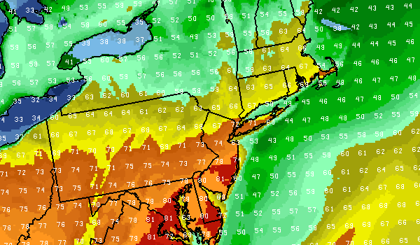
RAP model showing forecast high temperatures on Thursday. Notice the backdoor cold front settled to the south of our area over Southwest New Jersey and the Northern Mid Atlantic, with the core of the warm air now relegated to areas near Washington D.C and points south.

By Thursday, a backdoor cold front will have slid past the area from the north, leaving our area with east winds off the cool ocean waters. Clouds are expected on Thursday as well, and when coupled with the east winds will produce conditions noticeably cooler than the past several days. Highs in the 50’s to near 60 are generally expected, so the day won’t be a total loss. But it will serve as a reminder that summer warmth isn’t here to stay — yet.

Thursday: Mostly cloudy, with a chance of showers or drizzle. Highs in the upper 50’s. East winds around 10 miles per hour. Chance of precipitation 50%

Thursday Night: Mostly cloudy, with showers likely. Lows in the mid 40’s. East winds around 15 to 20 miles per hour. Chance of precipitation 50%.

Friday: Showers and thunderstorms likely. Highs in the upper 50’s. East winds around 20 miles per hour, gusting higher. Chance of precipitation is 100%.

Forecast: Spring warmth continues into Tuesday

Warm and pleasant spring weather has settled into the forecast area early this week, marked by a Monday which featured temperatures rising into the mid 70’s for the first time this year. Tuesday will feature much of the same, with temperatures running a few degrees warmer than they did on Monday afternoon. Despite the potential for some clouds early, winds are expected to shift to west-northwesterly by afternoon. The warm air aloft will have plenty of influence as well, with 850mb temperatures running over 10 C throughout much of the area. A bit of a gradient is expected throughout the area, with highs in the lower 70’s to the north of the city, and the upper 70’s to near 80 near the city and south of it over Central New Jersey.

NAM Model showing forecast highs throughout the area on Tuesday.

NAM Model showing forecast highs throughout the area on Tuesday. Notice the upper 60’s to lower 70’s north of the city, and upper 70’s to lower 80’s south of the city.

The seabreeze should be generally limited to the immediate coast on Tuesday, as well, with the offshore flow from the west-northwest. This will limit the progress of any marine layer as it attempts to move inland. The seabreeze had a much easier time moving inland on Monday with southeast winds off the water. Tuesday will mark the middle of the warmup for the area — with warmer temperatures expected once again on Wednesday. We hope you’re enjoying it as much as we are! (A backdoor front looms for Thursday with cloudy and drizzly conditions).

Today (Tuesday): Partly cloudy and warm, with highs in the upper 70’s to near 80. West-northwest winds around 10 to 15 miles per hour throughout the day, becoming noticeable and breezy in the early afternoon.

Tonight: Partly cloudy with a chance of isolated showers or thunderstorms. Lows in the middle to upper 50’s. West winds turning southwesterly around 10 miles per hour.

Wednesday: Partly cloudy and warm with a chance of isolated showers and thunderstorms. Highs in the low 80’s. Southwest winds around 10 to 15 miles per hour.

Forecast: Monday the start of a long awaited warmup

Partly cloudy skies are expected early Monday, behind a disturbance in the mid levels in the atmosphere which will move through the area overnight and early Monday morning. Rising heights aloft by afternoon, however, will allow for clearing and mostly sunny skies during the day. Temperatures will rise by afternoon, into the 60’s and lower 70’s especially across Central and Northeast New Jersey as well as New York City. After several days of below normal temperatures to begin spring, the warm air will feel all the more pleasant.

At noon time on Monday, temperatures generally should be from the upper 60’s to low 70’s across New Jersey — and in the 60’s along the coastline with slightly cooler temperatures across Eastern Long Island and the NJ Coast.

A seabreeze is expected to develop by late afternoon, however, owing to developing southeast winds. The wind direction will usher in a marine layer off the cool ocean waters which will serve to cool temperatures down by afternoon across Long Island and New Jersey Shore. By late afternoon, the seabreeze should make some westward progress towards New York City and Northeast New Jersey as well. Some clouds and drizzle are expected Monday evening, with the potential for showers and even a rumble of thunder into Tuesday morning. The showers will form thanks to a weak low pressure system which will be riding along an approaching warm front. This warm front is important — it passes our area by Tuesday and will bring the potential for even warmer temperatures (near 80!) across parts of the area Tuesday afternoon.

Forecast high temperatures through mid-week. Graphic created Sunday April 7th at 10:50pm.

Forecast high temperatures through mid-week. Graphic created Sunday April 7th at 10:50pm.

The forecast becomes a bit more complicated from the middle of the week into the tail end of the week, with model guidance struggling to pinpoint the location of a warm front. The positioning of the front will have drastic implications on our weather — just a few miles could make a 10 to 20 degree temperature difference! For now, it appears most models are in good agreement that the warm front will clear our area to the north. For more details and technical reasoning and thoughts behind the forecast this week, check out our Forecast Discussion.

Monday: Partly cloudy early, then becoming mostly sunny. High in the upper 60’s to lower 70’s. A bit cooler near the coast. Winds west, shifting to southeast around 10 miles per hour by evening.

Monday Night: Becoming cooler and mostly cloudy. A chance of showers. Lows in the upper 40’s to low 50’s. Chance of precipitation is 30%.

Tuesday: Partly cloudy early, then becoming mostly sunny. Warm. Highs in the upper 70’s to near 80. Warmer across Central New Jersey. Westwinds around 10 miles per hour.

Forecast: Weekend brings long awaited warmup for some

NAM model's forecast temperatures Sunday afternoon. Notice the sharp gradient along the coast. Much of NJ is in the middle 60's, while the NJ Shore and Long Island are in the 40's and 50's.

NAM model’s forecast temperatures Sunday afternoon. Notice the sharp gradient along the coast. Much of NJ is in the middle 60’s, while the NJ Shore and Long Island are in the 40’s and 50’s.

For now, the days of crisp winter-like cold air and blustery northwest winds will become a thing of the past. Building heights aloft and a moderating airmass will provide the foundation for a warming trend in temperatures this weekend, beginning on Friday. As a storm system skims our area and passes offshore (providing some showery conditions early Friday morning), clouds will thin by Friday afternoon and the sun is expected to return. Temperatures will rise into the upper 50’s to near 60 for highs. The air will feel especially warm when compared to the past several days of below-normal temperatures. Coastal regions will have trouble warming up — as south-southwest wind trajectory still brings winds off the cool ocean waters.

It won’t be a direct transition to warmth through next week– and it won’t be all fun and games near the coast.  Forecast models are in disarray with the positioning of a warm front this weekend, which will make its way towards the area on Saturday and Sunday. Read more