-2")
Wintry pattern change coming by late next week
For any readers who want to know more about any potential rain tonight, as well as the weather for Friday and the weekend, check out our latest forecast discussion. There may even be some scattered showers and isolated thunder with a cold pool aloft, as mid-level lapse rates will be near 7C/KM tomorrow afternoon.
While our area sits in low level moisture and clouds, former Super Typhoon Nuri has transitioned into an extratropical storm, but is forecast to fall to pressures below 920mb! This would be one of the strongest extratropical cyclones on record.
This extremely strong cyclone will help to release plenty of latent heat and energy towards the Poles, which will generate an anomalously strong ridge in Alaska and western Canada. In short, as the extratropical system becomes a behemoth both at the surface and aloft, the strong jet stream and digging trough in the mid and upper levels create an anomalous ridge to their east, pumping a ridge from the West Coast into British Columbia. This ridge will be so strong that it will also flow into the Arctic, tanking the Arctic Oscillation. This allows the Polar Vortex to be weakened and sent to the south on the downstream side of the ridge.
Accordingly, forecast models are in good agreement that the Polar Vortex will split into two, with a piece sagging southward toward Southern Canada during the middle to latter part of next week.
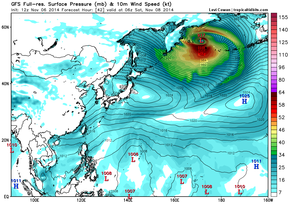
Today’s high-resolution GFS model valid for Saturday morning shows former Typhoon Nuri dropping to 917mb, as it passes just west of the Aleutian Islands. Image is courtesy of weatherbell.com
This is illustrated quite well on the latest model guidance, with a classic “ridge-bridge” from the western US all the way up to Alaska and the Arctic. By Sunday, parts of the Northern Plains and Northern Great Lakes will already be experiencing an Arctic blast.
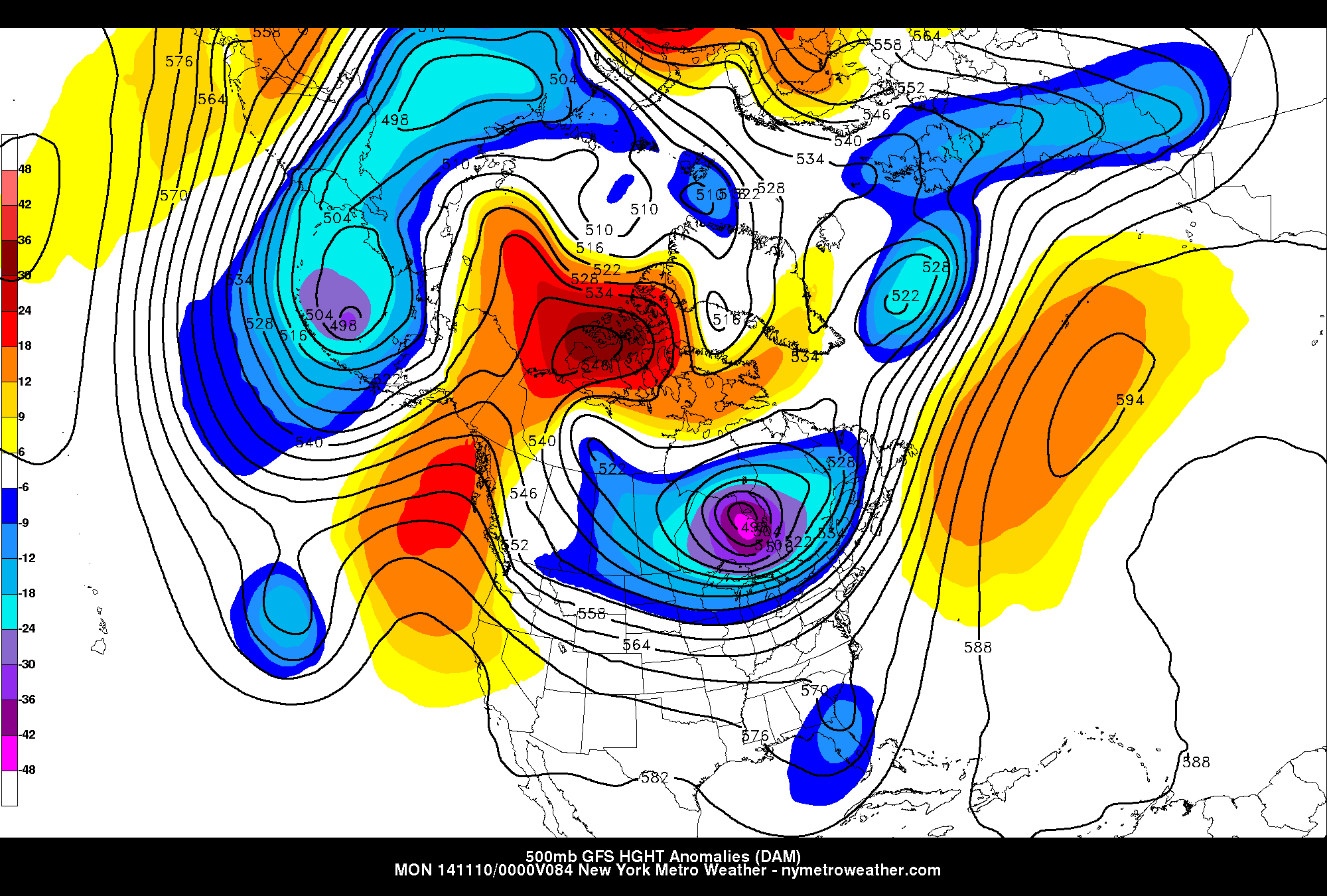
Today’s GFS model valid for Sunday evening shows the Polar Vortex entering the Great Lakes, with accordingly significantly negative 500mb height anomalies.
As a result, the pattern downstream becomes extremely amplified. Unseasonably cold air, typically bottled up in Canada, will surge south during the middle to latter part of next week as these lower mid level heights are displaced to the south. And the temperatures, both in the mid levels and at the surface, will respond.
Teleconnection wise, the AO response will be noticeable. While a -NAO develops as a result of high latitude ridging building into parts of Greenland and more importantly the area near the Davis Straight, the ridging extending north into British Columbia will tank the Arctic Oscillation to values near -3 by the middle to latter part of next week. We saw a similar drop (to values near -4) during the beginning to middle part of October.

The AO (Arctic Oscillation) forecast from the GFS model. For this discussion, the top graph is the important one. The black line shows the AO for the past several months. The red line begins today — and the several thin red lines show predicted values by GFS Ensemble members.
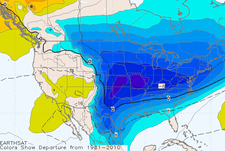
Medium range foreast models indicate the potential for much of the Eastern 2/3 of the United States, essentially from the Rockies to the East Coast, to fall well below normal in the temperature department by the middle of next week. While the worst of the cold, in terms of departures from normal and actual surface temperatures, will be in the Central US — airmass modification will only do so much to this airmass as is travels east.
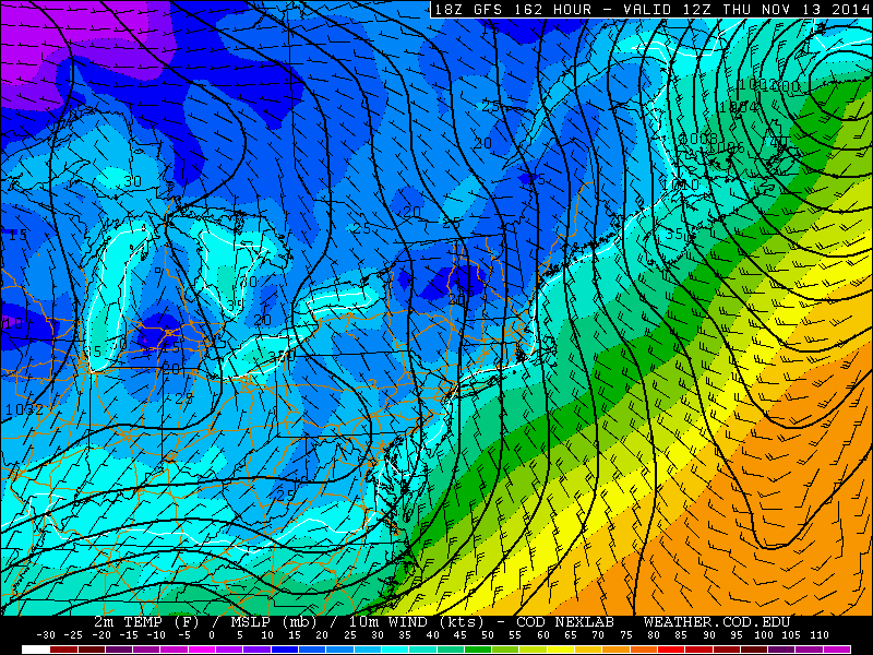
GFS model forecasting temperatures in the 20’s late next week into next weekend.
Most models indicate a high likelihood of the first freeze in most of our forecast area (At least for those who haven’t already experienced it), with blustery northwest winds. Highs may struggle into the 40’s at times as the airmass passes overhead. Additionally, it isn’t far fetched to say that the first flakes of the cold season could fly in parts of our area late next week into next weekend. While a “snowstorm” doesn’t appear likely at this time, the atmosphere will be cold enough to support flakes in any residual moisture that makes its way through the area.
In short, confidence is high that our area will be impacted by a surge of arctic air which will move through much of the Eastern 2/3 of the United States next week. While it won’t be bone-chilling, mid-winter cold, it will be a reminder of the fact that Autumn is here — and it may also serve as a precursor of things to come in the next few months.