Powerful ocean storm likely, worst impacts may stay seaward

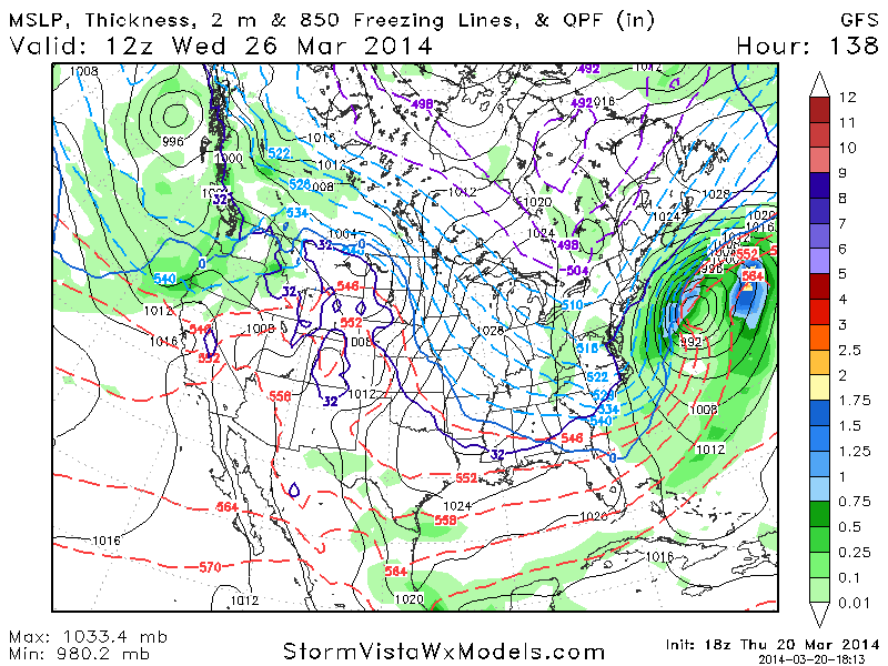
A mid and upper level atmospheric phase is likely to force the development of a significant coastal storm, which will rapidly develop off the East Coast early next week. The storm system is expected to begin strengthening off the southeast coast of the United States, before shifting northeastward over time. As a phase between multiple disturbances occurs in the mid levels of the atmosphere, and the mid and upper level jet streaks become favorable for strengthening, the surface low pressure will deepen rapidly and the storm system will mature.

Forecast models have come into better agreement over the past few cycles in regards to the track and intensity of the system, namely the area where the system will strengthen most as a result of the occurring phase. Arguably the most notable development in terms of sensible weather in our area, is the fact that the system will “hook” eastward before phasing, taking a track from a point southeast of the Outer Banks to a position south of the 40/70 benchmark. This likely will spare our area from significant precipitation in direct relation to the coastal low, as well as more widespread wind or coastal flooding impacts.

Euro model showing a significant storm a few hundred miles off the Northeast US Coast early next week.

Euro model showing a significant storm a few hundred miles off the Northeast US Coast early next week.

Read more

Concern rising for potential winter storm next week

The drum of what seems like an endless winter keeps beating on, and despite the warmth which has engulfed the area for a brief time this weekend, the beat will continue through the next 7 to 10 days. All forecast models agree on  below normal temperature departures becoming a common theme from the Central to Eastern United States beginning Sunday and continuing through the greater part of the upcoming week. Making things more interesting, undoubtedly, is the signal for a major coastal storm system on all forecast models and their ensembles. This has forecasters and hobbyists alike raising an eyebrow with eyes peeled on the potential system, which could impact the Eastern and Northeast US early next week.

Simply ripping and reading off forecast model’s specific outputs at this range, however, will get you nowhere. We’ve been down this road many times — several times this winter alone. A few operational forecast models start to show snowstorms in the medium range, a few people share it on social networks with big dramatic words, and suddenly all of the NYC Metro Area is lining up at Home Depot and Walmart. What needs to be understood is that, at this range in specific, any specific solution or outcome on forecast models is somewhat unlikely — and the bigger storm systems have very intricate details that won’t be ironed out until the event draws nearer. The counterpoint, with this system, however is the overwhelming majority of guidance now showing the threat. And when that starts to occur on operational and ensemble guidance, it becomes prudent to look at the meteorology behind the potential system.

GFS model showing a significant coastal storm staying east of the area early next week.

GFS model showing a significant coastal storm staying east of the area early next week.

Read more

Clouds, rain preclude late week warmup

A relentless winter pattern will come to a brief respite during the latter half of the work week and into the weekend, news which many have longed to hear. However brief the warmup may be, it will come with impeccable timing as calendar spring officially begins on Thursday March 21st. Nevertheless, it will come with a price as the second half of Wednesday will feature thickening clouds and a high likelihood of showers and periods of steady rain. A weak low pressure system developing nearby will help provide sufficent lift for a period of steady rain, developing from southwest to northeast later on Wednesday afternoon.

With the passage of a weak front and the aforementioned low pressure system by Thursday morning, will come a modifying airmass and (finally) a lack of new cold or arctic air. High temperatures, as a result, will reach into the 50’s on Thursday and Friday. Mid level ridging developing overhead late Friday night into Saturday will help to raise mid level temperatures additionally, so high temperatures are expected to approach 60 degrees early Saturday afternoon.

Simulated radar imagery for mid-evening on Wednesday showing widespread rain in the area.

Simulated radar imagery for mid-evening on Wednesday showing widespread rain in the area.

Read more

Mid-Atlantic snowstorm departs, temperatures moderate

Could this finally be the end? For the second storm in a row, dry air won out over much of Northern NJ, New York City and Southern New England causing any significant snowfall to be relegated to the Mid Atlantic states. A low pressure system developing off the coast from the Tennessee Valley brought bands of heavy snow as far north as Southern and Central NJ. 7-10″ of snow fell from Washington DC through parts of suburban Maryland into Southern NJ. and as the low pressure system exits off the coast on Monday, forecast models show very little threat for winter precipitation in the near future for the first time in months.

Despite the lack of winter storm threats, which appears to finally be coming to fruition after several straight weeks of snow potential in a row, the pattern is likely to remain cold with only brief spurts of warmth through the end of the month. The consistently elongating and morphing lobe of the Polar Vortex will remain in Eastern Canada, owing to a persistently anomalous Pacific pattern. But over time, models agree that the cold will become less starling and the chances for snow will decrease. For the first time, it looks like the proverbial light at the end of this year’s endless tunnel of winter is in clear view.

Regional radar imagery from 9:00am Monday March 17, 2014 showing snow moving southeast of NYC and out to sea. Image courtesy weather tap.

Regional radar imagery from 9:00am Monday March 17, 2014 showing snow moving southeast of NYC and out to sea. Image courtesy weather tap.

Read more