Weekend Update: 50 degrees tomorrow, then potential storm March 12

Plenty of clouds have been the rule for today, which have helped to keep temperatures in the 30s. A storm system to our south is slowly moving northward, but will not interact with the jet stream to the north. This will keep the storm system out to sea. The lower pressures from the jet stream to the north, as well as the lower pressures out to sea, will help to create a relative wedge of higher pressures between them, which is another reason why the storm will ultimately miss us, as higher pressures create sinking air, thus a lack of lift. There is the outside chance of a few very light sleet pellets or drizzle in coastal sections, but we’re definitely leaning against that, and even if that were to occur, it would not disrupt any travel.

As the storm pulls away throughout the night, clouds will gradually diminish, as winds turn to the north. The initial cloud cover will prevent temperatures from dropping much below freezing, however.

Moving to tomorrow, a cold front will be developing in the Great Lakes via the northern jet stream, and moving eastward throughout tomorrow. This will help to the winds to turn more westerly as opposed to due northerly. This, combined with the previous subsidence left from the departing storm system will lead to sunny skies for tomorrow and a potentially warm day.

Today's high-resolution NAM run shows 850mb temperatures around +3C at 1:00pm tomorrow afternoon, which support high temperatures in the 50s, given enough sunshine and mixing. (PSU E-Wall)

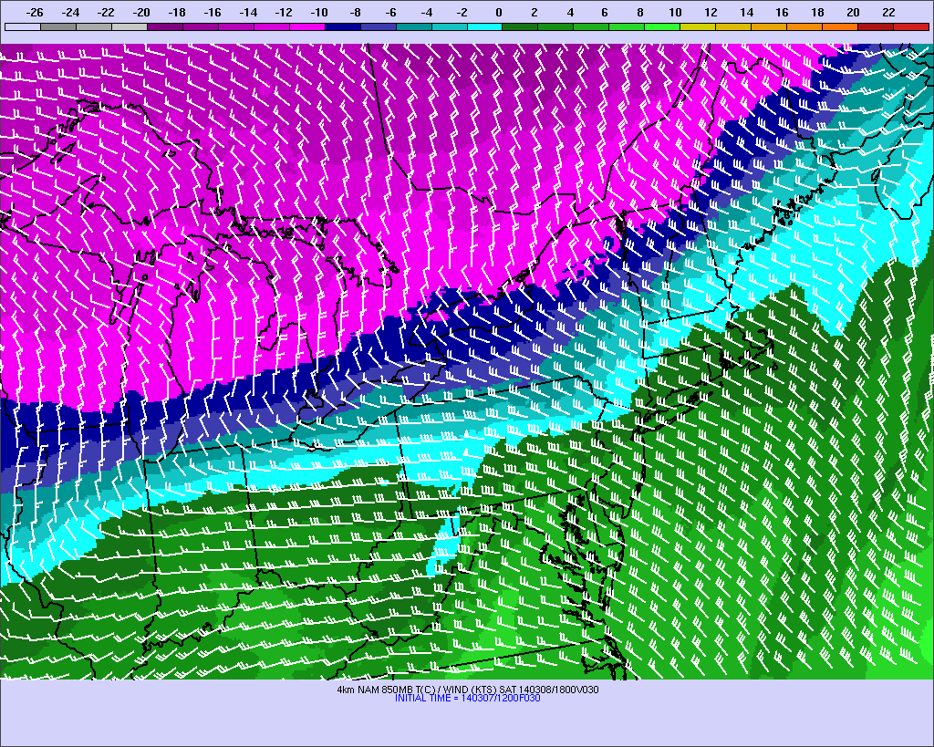
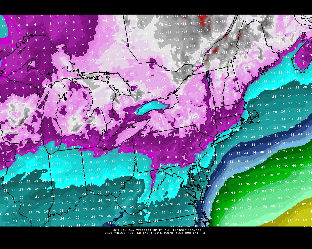
Today’s high-resolution NAM run shows 850mb temperatures around +3C at 1:00pm tomorrow afternoon, which support high temperatures in the 50s, given enough sunshine and mixing. (PSU E-Wall)

Temperatures aloft have slowly warmed due to more ridging building in between the low pressure offshore, and the low pressure in the northern stream. As sunshine comes out in full-force tomorrow, the relatively strong sun angle, combined with the fact that winds will be turning more to the west should lead to temperatures warmer than forecast by most other outlets. 850mb temperatures will be around +3C at 1:00pm and the flow will be pretty strong out of the west, as shown in the map above. This leads to downsloping off the Appalachian Mountains, which warms and compresses the air. The only thing that would prevent temperatures from exceeding 50 degrees is if the atmosphere takes a bit too long to become truly mixed, because of the previous higher pressures preventing much atmospheric turbulence. However, due to the winds and strong sun angles, we believe the atmosphere will become mixed by around noon or 1:00pm. This would help to translate the warm temperatures aloft to the surface. With a strong sun angle, you can often add 10 to 12C to the 850mb temperatures to the surface.

Interestingly enough, BUFKIT soundings show the atmosphere becoming fully mixed at 3:00pm, but temperatures aloft have cooled a bit by then, due to the approaching cold front — when a cold front approaches, the temperatures aloft fall faster than they do at the surface, due to stronger winds aloft. This is why most high temperature forecasts are only in the 40s for tomorrow. But just move the mixing up a couple of hours, and we are easily in the 50s for tomorrow, which seems to make sense given the strong sunshine. Thus, we feel that temperatures should reach the low 50s tomorrow, which will feel quite pleasant due to how cold it had been previously. Average temperatures this time of year are actually in the mid to upper 40s, so tomorrow’s warmth will not be unseasonable.

The cold front moves through on Saturday night, which will lead to Sunday having trouble getting out of the 30s, as well as some scattered snow showers on late Saturday night/early Sunday morning. Then, attention shifts towards Wednesday, as another potential storm begins to form.

Read more

Cold tonight and tomorrow, otherwise a relatively quiet week in weather

After getting bombarded by storm after storm this winter, it appears that the pattern for the next several days will finally relax, as no major storm systems will be on the horizon. There is a storm system developing in the Southeast states, but it will be become disconnected with the jet stream. This means that there will be no northern stream piece of energy to phase with it and bring it up the coast, thus the storm will stay to our south for Thursday and Friday.

Another inconvenience we have to deal with, however, is the cold temperatures for tonight and tomorrow. Today saw decent moderation, as the previously cold high pressure system slid out to sea, and allowed our flow to become more maritime in nature. But as this high pressure system moves out, another strong one will be moving in tonight and tomorrow. A 1040mb high pressure system will pass overhead, and allow for our winds to turn due northerly tonight, which is the most efficient way to generate cold into our area, since that wind direction allows for no downsloping, nor moderation.

While this run may be slightly overdone in cold, the 4KM NAM shows bitterly cold temperatures being advected into the region tonight. (PSU E Wall)

While this run may be slightly overdone in cold, the 4KM NAM shows bitterly cold temperatures being advected into the region tonight. (PSU E Wall)

The wind direction coming purely from the north via a 1040mb high (strong cold air source) leads to forecast very cold temperatures tonight — dropping into the mid teens in the City, and perhaps upper single digits to around 10 in northern and northwestern suburbs. There won’t be any true radiational cooling, however, due to the strong winds, so temperatures may tend to run a bit more uniform tonight.

Some data indicates the initial slight chance for a snow shower tonight as temperatures aloft drop more than they do at the surface initially, creating some instability. However, we feel that the strong high pressure system will create enough subsidence to limit any snow shower activity, except for areas further north and west with a bit more elevation/orographic lifting.

Read more

Explaining the forecast bust

Although our forecasts were lower in snow totals for the NYC area than some other outlets at the time they were issued, we still feel like we could have done a better job. Apologies go out for a missed forecast. But, as scientists, we always try to do our best to analyze what went wrong, and how this could help improve forecasting down the road. We did have lots of ideas and gave some warning about the uncertainties with the storm and the beginnings of the south trend in this article, as well as giving a brief explanation of why the storm was trending south in this article, but we did not reflect these thoughts strongly enough in our forecast maps. We will begin dissecting the several aspects that went into the forecasts and how everything changed.

1) Previous computer model forecasts not only consistently showed a major snowstorm, but they made sense given the general pattern they were forecasting.

Sometimes when computer models forecast a snowstorm, they may come up with what we call a “pulling a rabbit out of a hat” solution, where lots of features luckily and coincidentally fall into place, in a general pattern that does not necessarily support these features falling into place. That does not mean snowstorms are impossible in those scenarios, but they are less likely.

This time around, however, there were many favorable features, at least initially. A relatively potent southern stream shortwave ejecting into an Arctic airmass, and pieces of energy from the northern stream of the jet stream were diving down and interacting with the southern stream, helping to pull more moisture northward.

The 00z Friday European Model run showed quite the favorable pattern for a major snowfall for New York City. But small changes with the handling of the Polar Vortex and associated energy led to exponential shifts in the eventual track.

The 00z Friday (2/28) European Model run showed quite the favorable pattern for a major snowfall for New York City. But small changes with the handling of the Polar Vortex and associated energy led to exponential shifts in the eventual track. Image credit goes to the WSI Model Lab.

Read more

Live Blog: Steady snow stays well south of NYC

1:45am Update: Steadier and heavier snow is beginning to develop near Philly and Northern Delaware. It is heading to South Jersey as we speak. Over the next couple of hours, any initial rain or mix in Burlington County and Ocean County and southward will quickly turn over to snow, and accmulate about 1″ per hour — perhaps even up to 2″ per hour in quick bursts. Due to the quickly accumulating snow and the fact that there is no solar insolation to warm the roads, roads will become slick pretty quickly.

Radar Imagery as of 1:33am EST.

Radar Imagery as of 1:33am EST. You may need to click to animate.

This heavy band of snow is falling as a result of a strong area of frontogenesis. In essence, frontogenesis is an area of a strengthening front, where the temperature gradient is increasing (cold areas are getting colder, and warm areas are getting warmer). This leads to enhanced lift in the atmosphere. Not surprisingly, the strongest frontogenesis is headed for Southern New Jersey.

Latest 850mb frontogenesis is pretty strong in northern Delaware, and is heading for Southern New Jersey.

Latest 850mb frontogenesis is pretty strong in northern Delaware, and is heading for Southern New Jersey.

There are some weaker areas of frontogensis trying to streak northward towards NYC. Thus, even in areas north of Central NJ, light to at times moderate snowfall will be developing throughout the overnight. We still do not anticipate more than an inch of snow north of NYC, but an inch or so could still fall in the NYC area and Long Island — max potential is 2″. This includes western suburbs as well. So although not much snow is expected, enough could still fall to create some minor issues on the roadways.


9:45pm Update: The south trend never stopped. As time has gone on, models have better picked up the true impacts of a strong Polar Vortex, which is to suppress precipitation to our south. For more on why this has occurred, check out our article from yesterday. 

High resolution model trends, along with radar and surface observations are indicating that dry air and subsidence will be the rule for NYC and points north, where perhaps only a dusting of snow will fall. Perhaps an inch of snow or so for the south shore of Long Island, through Staten Island and Union County and points westward. Middlesex County looks to receive 1-3″, with the 3″ being on the southern end of the county. Snowfall totals exceeding 3″ will not be reached unless in southern Monmouth, and Mercer County, and points southward. Burlington and Ocean County could still receive 4-8″ of snow (closer to 4″ in northern sections, closer to 8″ in southern sections). Camden County and southward could still receive snowfall totals in excess of 8″, and perhaps even approach a foot, with heavy snowfall at times, so we will make sure to keep this blog updated for these residents.

Although the GFS shows totals a little higher for northern sections, we believe that its low resolution is not picking up on how sharp the cutoff in precipitation will be.

Here is the most recent HRRR Model’s precipitation output valid through 10:00am tomorrow, with steady snow still falling in Southern Jersey.

The most recent run of the HRRR (High Resolution Rapid Refresh model) shows heavy precipitation remaining to the south.

The most recent run of the HRRR (High Resolution Rapid Refresh model) shows heavy precipitation remaining to the south.

We believe ratios will be about 12:1 or so, so multiply these numbers by 12 to get an expected snowfall total. Heaviest snow in Central and Southern Jersey looks to from 3:00am through at least noon, with the heaviest centered between 7:00am and noon. Be sure to give yourself a lot of extra time for the morning commute if you are in these areas.