-2")
The rise and return of a strengthening El Nino
El Nino has arrived, and it continues to strengthen, with increasing potential to become a powerhouse by Autumn and Winter.
Computer models and meteorologists are growing more confident that a strong El Nino will develop by this Autumn and Winter, with some computer modeling even suggesting that it could rival the 1997-98 “Super El Nino” which remains the strongest on record.
El Nino refers to the periodic warming of waters in the central and eastern Equatorial Pacific, which has a cascading effect on weather systems around the globe. In normal years, the atmospheric circulation allows trade winds to converge around the equator in the Pacific, blowing from east to west. But this year, trade winds are pushing in the opposite direction, bursting from west to east. This helps transport warmer waters, which typically lie in the Western Pacific, farther east — and dramatically changes the atmospheric circulation.

The circulation patterns typically associated with an El Nino, both at the surface and underwater. (Australian Bureau of Meteorology)
As you may recall, forecasting the development of El Nino has proven to be quite difficult. Last year, the National Weather Service suggested favorable odds for the development of a strong El Nino, which never occurred. But with El Nino conditions well-established and westerly wind bursts continuing, meteorologists are increasingly confident in its development and strengthening.
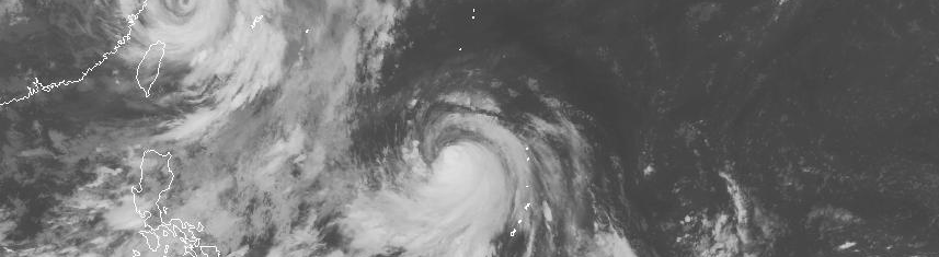
The intensification of several Pacific Ocean Super Typhoons earlier in the year helped to bring down a series of westerly winds through the Equatorial Pacific, allowing warmer water to shift east over the El Nino regions. The ripple effect has continued for several weeks. Even as we speak, another strong burst of westerly winds is occurring, partially owing to the development of Super Typhoon Chan-Hom.
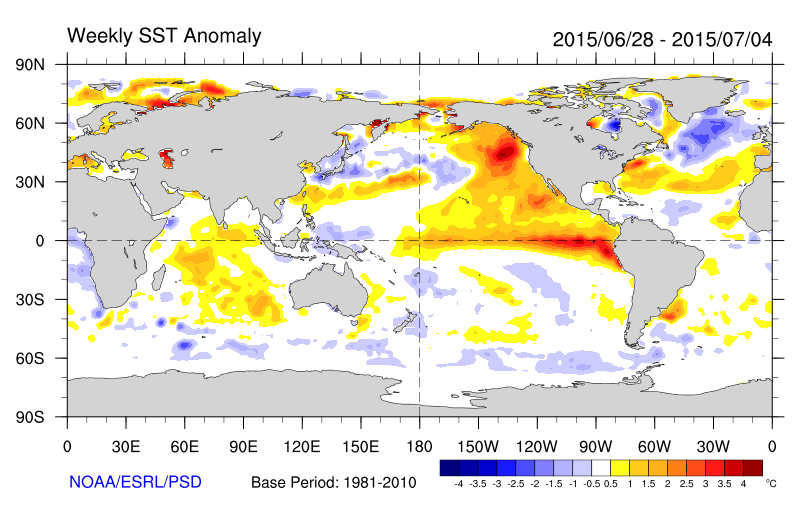
Sea Surface Temperature Anomalies during the past few weeks (ESRL/NOAA).
This, quite often, can become a feedback process. Think of it this way: Typhoons help cause westerly wind bursts, which also cause warmer waters to shift farther east in the Pacific, which causes more typhoons. The process can often continue for months — and the waters continue to warm while pushing eastward.
For simplicity, the Climate Prediction Center (CPC ) calculates the El Nino by measuring the sea surface temperature in the region from 170 degrees west to 120 degrees west, often referred to as El Nino region 3.4. Currently, temperatures in those regions are 1.4 degrees Celsius above average, falling into the category of a moderate (and nearly strong) El Nino. The CPC categorizes El Nino events based on tri-monthly periods. Over those three months, a weak event features ocean temperatures of 0.5 to 0.9 C above average, a moderate event 1.0 to 1.4 C above average, a strong event 1.5 to 1.9 C above average, and a “Super” event 2.0 C above average or higher. For comparison, the “Super El Nino” in 1997-1998 saw temperature anomalies of 2.3 degrees Celsius above average.
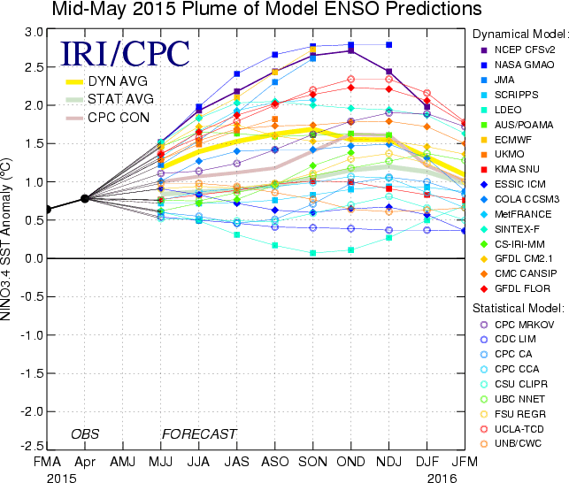
Forecast sea surface temperature anomalies in the 3.4 region by several forecast models over the next few months (ESRL/NOAA).
So, what does all of this mean for our weather? The answer lies in the analysis of changed atmospheric circulations. Increased warmth along the Equatorial Pacific allows for the Pacific Jet Stream to be farther south than normal, and stronger. This often pushes southward into the Tropical Atlantic, hindering the development of Tropical Storms and Hurricanes. Not surprisingly, meteorologists and computer models are predicting a damped Atlantic Hurricane Season. In addition, it often leads to tremendous amounts of moisture flooding into the Southwest United States and California. The 1997-98 El Nino event is famous for its California flooding which caused $550 million in damages.
The southward push of the Pacific Jet Stream also allows troughs, or areas of colder air aloft and at the surface, to move farther south in the United States during the summer. This, more often than not, promotes cooler than normal temperatures with more precipitation than normal in the Northeast United States, including New York City.
The effects on sensible weather become more prolific in the cold season. During these seasons, the mid-level jet stream becomes more amplified and active. Frequent storms with plentiful moisture occur in the United States, owing to the aforementioned Pacific Jet Stream, but the cold air and Polar Vortex are displaced farther north. Less extreme Arctic Outbreaks occur in the Northern third of the United States, with temperatures averaging warmer than normal. El Nino events have been linked with lowly ski seasons in the Northeast United States.
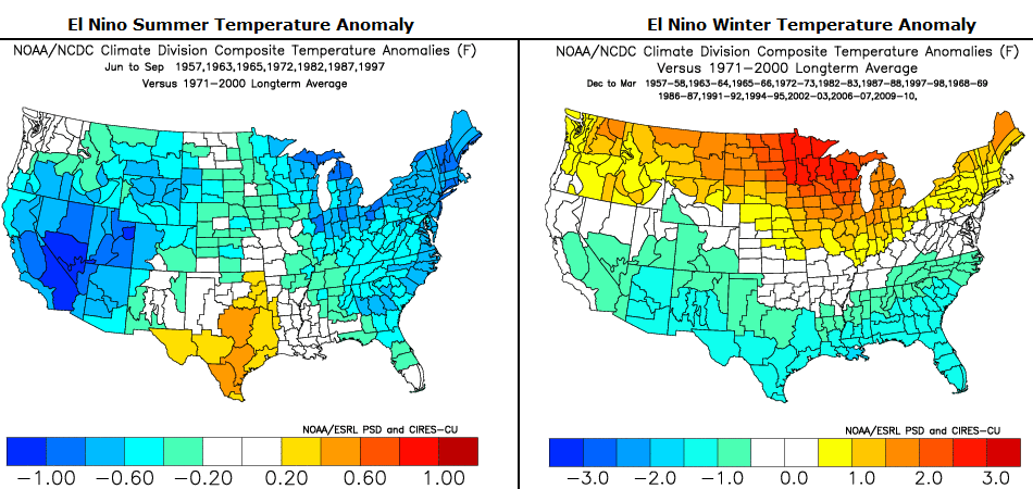
In New York City, the effects of a moderate or stronger El Nino can be notable. The dataset and composite images above show temperature departures from normal during moderate or stronger El Nino events in the past. Temperatures here during the summer months average about one full degree below normal. Conversely, during the winter months, they average about one full degree above normal. These aren’t small numbers, they correlate strongly with the changing atmospheric circulations discussed above.
While every El Nino is different, with separate atmospheric effects, we can continue to draw on the aforementioned past events as analogs over the next few months. While confidence in a strong El Nino is rising, the exact evolution of the event remains uncertain. Meteorologists will be pouring over data and information as the forecast continues to evolve. We invite you to stay tuned with us for updates and the latest installments of information over the coming months.
This article was written by John Homenuk and Doug Simonian