The meteorology, and stats, behind the 2015 Hurricane Season
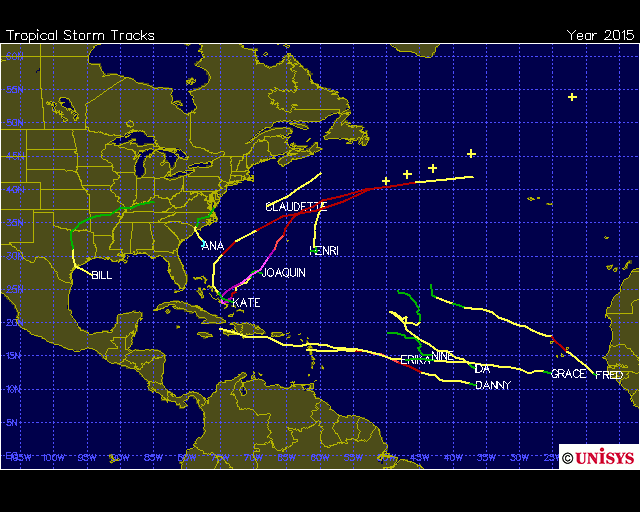
Meteorological Winter began today, and the 2015 Hurricane Season officially ended yesterday, marking a transition in seasons — and the attention of meteorologists worldwide. While the season will be remembered for a few more significant storms, the overall season in the Atlantic was quiet. There were 11 named storms and one more tropical depression. Four of those named storms became hurricanes and two of those became major hurricanes (Category 3 or higher). The number of named storms is actually about average for Atlantic hurricane seasons between 1966-2009. But the number of hurricanes is below the average of 6 for the season. Only two storms made landfall in the in the United States: An early season tropical storm named Ana over North Carolina in May, and then Tropical Storm Bill over Texas in June. There hasn’t been a major hurricane landfall in the United States since Hurricane Wilma in 2005 — which is now 10 years ago.
This year’s hurricane season was heavily influenced by the strengthening El Nino in the Pacific. This climate pattern typically supports a tropical upper tropospheric trough (TUTT) causing stronger upper-level shear over the Caribbean and Tropical Atlantic. Strong shear is unfavorable for tropical systems to keep convection (or thunderstorms) around their center of circulation. If shear is prevalent through much of the season, it tends to reduces the number of named storms and the number of those that become hurricanes. For this reason, the anticipation from many meteorologists beforehand for a less active season in the Atlantic.

300mb zonal wind anomalies (m/s) were higher than normal from the Caribbean to African coast between June and October on average. This indicates with strong upper-level shear environment with the tropical upper tropospheric trough (TUTT)
Many tropical cyclones this season experienced strong upper-level shear and dry air near the TUTT. This limited the amount of hurricanes in the Atlantic. According to the National Hurricane Center (NHC), the Accumulated Cyclone Energy index (ACE), was only about 58% of the 30-year average. A couple tropical cyclones gained more attention due rapid changes of intensity or forecasts to hit the US coast. A couple examples here are Danny and Erika in August. But neither storm had a major impact.
Danny was small tropical cyclone which formed August. This made it more susceptible to changes in the atmospheric environment. Danny could intensify rapidly under more favorable environment and weaken just as much under a less favorable environment. Such large fluctuations in intensity are more difficult for the global models to handle because of their larger resolutions.
As Danny approached the Lesser Antilles, it began feel the effects of southwesterly shear from the tropical upper tropospheric trough (TUTT) over the region. But this stronger shear was northwest of the inner core of Danny. This initially ventilated Danny and helped it rapidly intensify into Category 3 hurricane. Once Danny was further west, stronger shear started finally reached the inner core: accelerating rapid weakening.
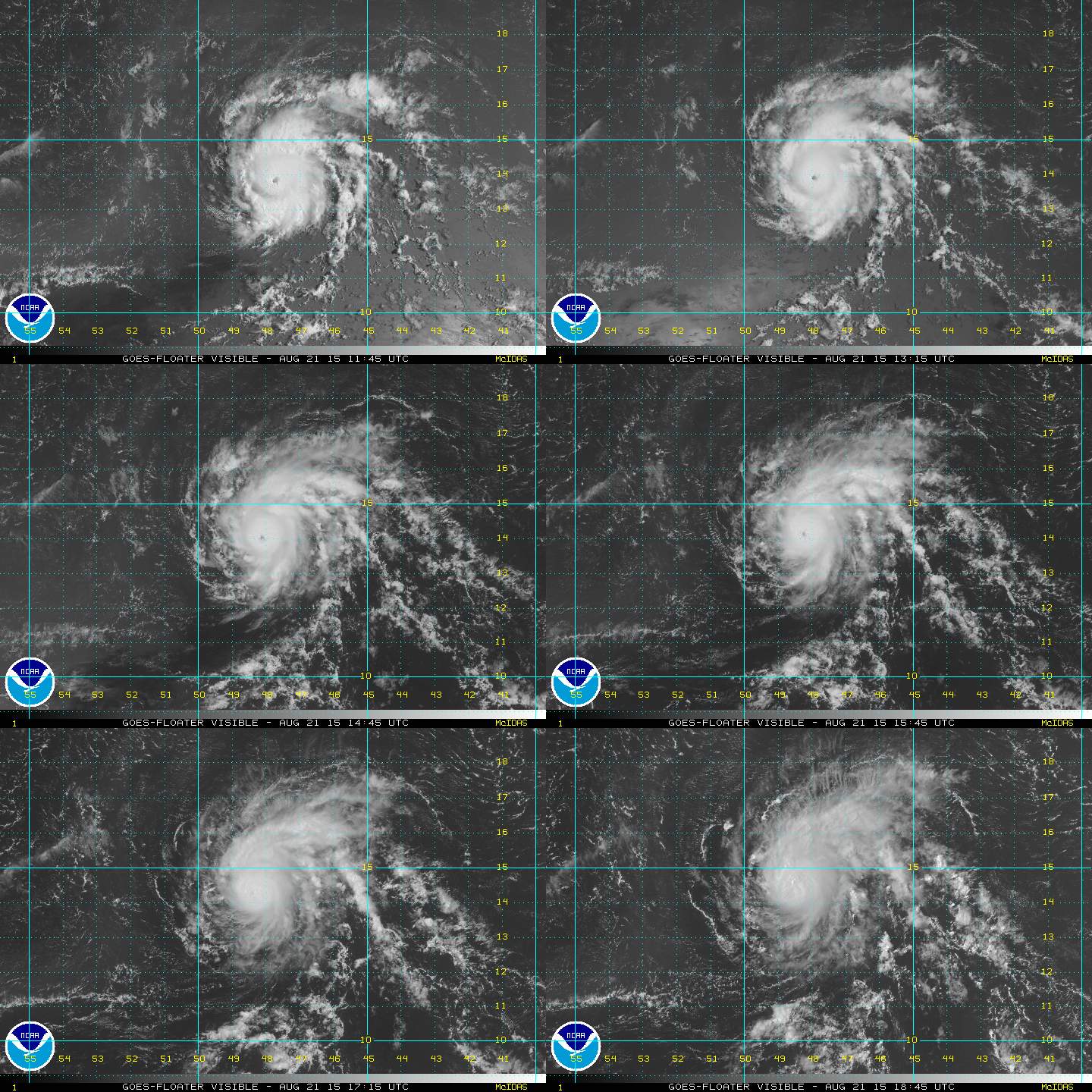
Hurricane Danny as a Category 3 hurricane in the Central Atlantic. Eye closes as it underneath stronger upper-level shear.
In Erika’s case, the intensity of the storm in the first 24-48hrs were often a huge factor in forecasts, because a deeper a tropical cyclone would be able to respond a weakness in a sub-tropical ridge over the extreme Western Atlantic. The global models–particularly the GFS, ECMWF, and UKMET– were less consistent on the intensity of Erika due to amount of middle to upper level shear being produced by the TUTT, in the region. The lower shear would allow Erika to strengthen more and track north of the Caribbean. The higher shear over Erika would help Erika to stay weak and track further south over Hispaniola and Cuba. The latter solution turned to be final outcome.
The Canadian model seemed in world of it’s own. It produced a number of solutions where Erika’s remnants phased with an upper-level low. This resulted in a strong hybrid-tropical system near New Jersey or Delmarva region. This was always an outlier solution, with a model that has a well-known bias in overdeveloping cyclones. Every model solution used in forecasting should be analyzed, before immediately discounting or accepting its solution. But in general, we strongly advise against using the Canadian model primarily for tropical cyclone forecasting.
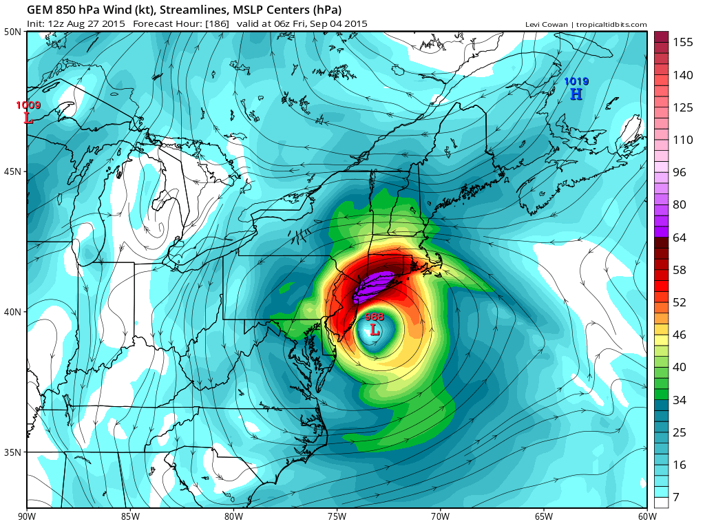
The Canadian model shows Erika off the Southern NJ coast with 74kt+ at 850mb level. This solution never came to pass.
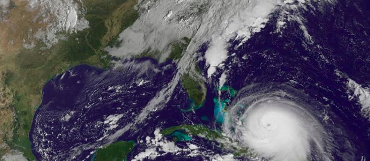
The biggest highlight of the Atlantic season was Hurricane Joaquin. This was another tropical cyclone that developed east of the Bahamas in late September. This storm started as a tropical depression or weak tropical storm, underneath strong upper-level shear for a few days. The shear gradually weakened, as an anticyclone (ridge or high pressure) built over the center of circulation. With a more favorable atmospheric environment and very warm sea-surface temperatures, Joaquin was able to rapidly intensity into a major category 3 hurricane on October 1st. After some slight weakening over the Bahamas, it re-intensified into a strong Category 4 hurricane with maximum sustained winds at 155mph on October 3rd. By then, the storm was forecast by the NHC to recurve away from the US East Coast.
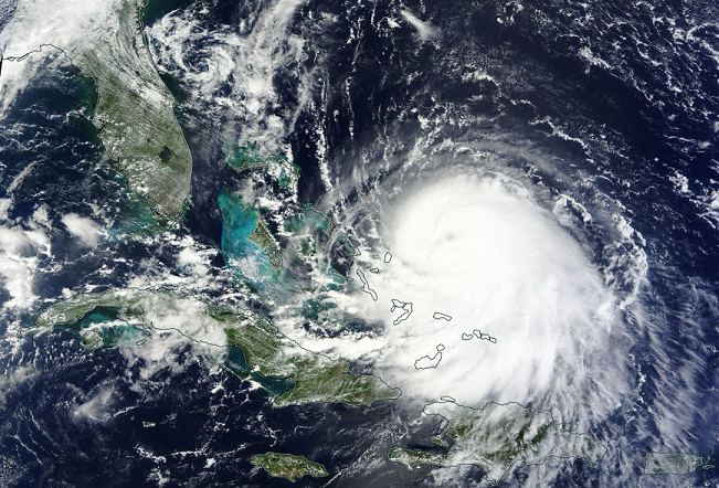
Visible satellite image for Joaquin from September 30, 2015. Image credit: NASA
Most models struggled with the future intensity and track of Joaquin. There was a blocking ridge over the Western Atlantic and upper-level low over the Southeast US. Many models suggested this would cause Joaquin to track toward Southeast or Mid-Atlantic region. The National Hurricane Center had often followed the consensus of these model solutions, in their forecasts.
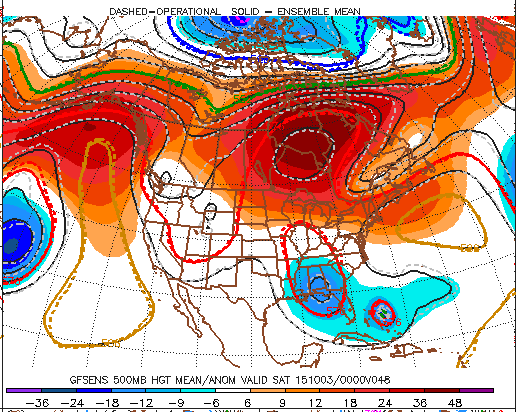
The GEFS at 500mb level (18kft) showing blocking ridge over the Western Atlantic, Upper-level low over Southeast US and Joaquin embbeed in weakness underneath ridge.
However, the ECMWF model was showing for several runs that Joaquin would be able to escape into a weakness underneath the ridge, being caused by an upper-level trough and remnants of another tropical storm named Ida in the Atlantic. It was an outlier, at the time, compared to the overall model consensus. But the ECMWF was able to catch on to Joaquin’s initial slow track farther southwest into the Bahamas, which would the allow the upper-level low over Southeast to kick it northeast, rather than capture and phase with it. Other models kept correcting Joaquin’s initial track to the southwest, before finally showing Joaquin re-curving out into the open Atlantic.
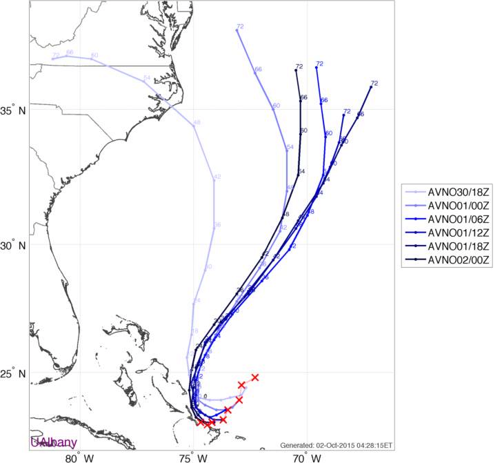
GFS (AVN) initial forecast errors and track forecast afterwards for each run (Image credit: UAlbany)
Even one run of the GFS gave us a localized scare, on the evening of October 1st. The GFS showed Joaquin captured by the upper-level low over the Southeast US, hooking back toward the coast, and making landfall over Southern New Jersey. This was the night before Joaquin reached Category 3 status. The GFS sounding on BUFKIT for Atlantic City,NJ showed potential for winds at Category 2 strength to mix down to the surface in the form of strong wind gusts. If that solution had verified, local impacts would have been immense.

0z GFS on the night of Sept. 30th showing Joaquin nearing the Southern NJ. This solution never came true.
Joaquin ultimately wound up curving out into the open Atlantic. However, we still saw some rainfall from the upper-level low to our south which enhanced ift and moisture transport off the Atlantic. The pressure gradient between a strong high over the Canadian maritimes and the upper level low still caused a strong easterly flow. High tides were running above normal due to a full moon. This all lead to some minor-moderate coastal flooding during high tide cycles, along the Mid-Atlantic shores up to New Jersey and Long Island.
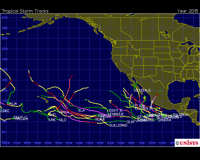
While we pay most attention to hurricanes in the Atlantic, the Eastern Pacific had a few events that were of more interest this year. Due to the very warm ocean temperature, it is typically more active over Eastern Pacific during strong El Nino years. There were 18 named storms and 4 additional tropical depressions in the Eastern Pacific. Twelve of those named storms became hurricanes and nine of those that became major hurricanes:
The most notable storm this season was obviously Hurricane Patricia, which became the strongest hurricane on record in the Western Hemisphere. On October 23, hurricane reconnaissance flying into the storm early in morning and later in the day, found maximum sustained winds of 200mph and a pressure of 879mb. Patricia later made landfall over Southwest Mexico, near Cuximalla as Category 5 storm with maximum sustained winds of 165mph. The hurricane weakened before landfall, as it underwent an eyewall replacement cycle and it’s 15 mile wide area of highest winds spared more urban areas from catastrophic destruction.
Patricia’s winds broke the previous record from Hurricane Allen over NW Caribbean in August 1960, which had maximum sustained winds up to 190mph near the Yucatan Peninsula. Patricia’s pressure broke previous record lowest pressure of 882mb from Hurricane Wilma over the Northwest Caribbean in October 2005.
In September 1997, Hurricane Linda formed and became the strongest hurricane in the Western Hemisphere at that time with maximum sustained winds at 185mph and minimum pressure at 902mb. This was previously the strongest hurricane for the Eastern Pacific and it occurred during the “Super El Nino” of 1997-98.

29°C to 31°C sea-surface temperatures off Southwest Mexico provide more fuel for hurricanes in the Eastern Pacific
Another record was broken recently in Eastern Pacific: Hurricane Sandra, in the last full week of November, became the latest tropical cyclone to reach major status on record for the Eastern Pacific. Sandra, at her peak, was a Category 4 hurricane with 145mph winds on Thursday, November 26th. It was able to intensify rapidly again, due to the warm very warm sea-surface temperatures. However, increasing upper-level shear caused the storm to weakened rapidly to a remnant low before it reached the Baja Peninsula on Saturday, November 28th.

