-2")
Warmth on borrowed time as January pattern change looms
Old man winter may finally be waking up. After a December which, to this point, has featured historically warm temperatures and an overall lack of snow, a well anticipated pattern change now looks increasingly likely to play out during the middle part of January. In fact, forecast models suggest the pattern change is already underway, and the effects of it may be felt a bit earlier than anticipated when we released our Winter Forecast back in early November.
The atmosphere is already undergoing significant changes which will have a tremendous impact on the sensible weather in our area within about two weeks time. Most interesting of all? Those changes are beginning (and are currently most notable) thousands of miles away, in part of the Arctic Ocean north of Sibera known as the Kara Sea. That’s not all, however, a myriad of hemispheric changes are expected over the next few weeks.
A record breaking Barents/Kara Sea ridge
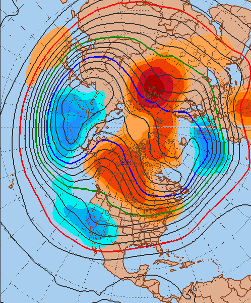
Thousands of miles away, forecast models are in great agreement that over the next few days, a tremendously anomalous ridge will develop through the Kara Sea. This ridge will quickly become the most dominant feature on the globe, especially in the mid levels of the atmosphere. It’s strength and presence will change the global circulations around it — and also force a disruption to the lower levels of the stratosphere.
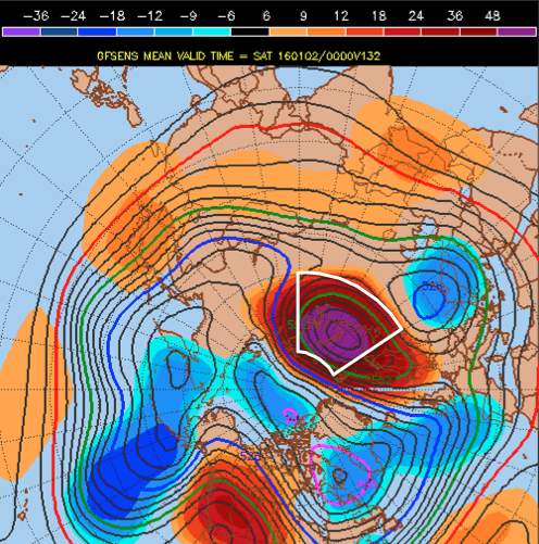
GFS Ensembles showing an exceptionally strong ridge in the Kara Sea next week. (Sam Lillo)
Research on height records in the Kara sea during the months of December, January, and February shows that the GEFS are forecasting this ridge to be the strongest ever during this time period — by a fairly wide margin. Only a few years come remotely close to the strength of the forecasted ridge and heights in the mid levels of the atmosphere. This ridge will be a catalyst in setting off changes to the mid level atmospheric pattern.
As it develops, it will push northwestward toward the higher latitudes near the Pole, aiding in the development of some high latitude blocking. When juxtaposed with a ridge on the Western part of North America (which we will discuss shortly) it helps disrupt the polar vortex which had previously, for much of December, been quite stout and centralized.
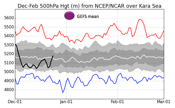
GFS Ensemble forecast strength of the Kara Sea ridge compared to previous occurrences (Sam Lillo)
The disruption and displacement of the stratospheric polar vortex
With an assist from the Barents/Kara Sea ridge, the stratosphere will finally become disrupted over the next week. This disruption is expected to continue into the weeks beyond and through the middle of January. Up to this point in the Autumn and Winter, the stratospheric polar vortex has been extremely profound, quite cold, and not very mobile.
As a result, much of the real polar air has remained “bottled up” near the poles. Think of it this way: A mobile, disrupted stratospheric vortex can help create a pattern that enhances the potential for ridges and blocking in the higher latitudes, effectively dislodging arctic air farther away from the poles (and sometimes toward our area).
Over the next few weeks, forecast models are in good agreement that this stratospheric polar vortex disruption — or possibly even split — will continue. This will continue to promote a higher likelihood of high latitude blocking with each week that goes by, with obviously some variance within a “step down” process. Nevertheless, the disruption of the stratospheric vortex will be a huge player in the pattern change through January.
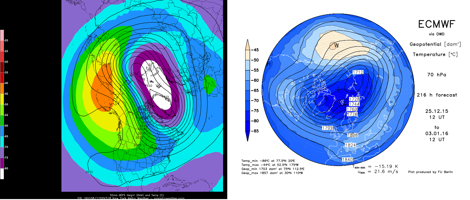
GFS and ECMWF stratospheric forecasts showing a significant stretch/displacement of the stratospheric polar vortex.
A retrograding trough from the Gulf of Alaska to the Aleutian Islands
One of the worst signs for snow lovers is a large, broad trough in the Gulf of Alaska. This means a few things, but namely, it suggests a -PNA (Pacific North American Index) and a broad trough or lower than normal heights from the Gulf of Alaska to the West Coast of the United States. This naturally promotes more ridging farther east, through the Central and Eastern United States. While not impossible, getting appreciable cold air or snowfall with that pattern is quite difficult.
For much of December, that exact broad trough has made a home from the Gulf of Alaska to the West Coast of the United States. Forecast models, now, are in good agreement that this ridge will begin adjusting westward. Owing to the aforementioned development of high latitude blocking, and a displaced stratospheric vortex, the trough over the West Coast will readjust farther west. Forecast models agree that ridging, or higher heights, are likely to setup from the Northwest US into British Columbia — a +PNA — with the tendency for a -EPO (East Pacific Oscillation) to develop as well.
GFS Ensembles forecasting a trough near the Aleutian Islands and ridging on the West Coast of North America.
Meanwhile, underneath this ridge on the west coast, a “split flow” will develop. This occurs when troughing undercuts a large atmospheric ridge, allowing for energy to surge east or northeast. Thanks to the active subtropical jet (El Nino!), the pattern could support both a ridge on the west coast, and a very active pattern with multiple storm systems ejecting east into the Central and Eastern United States
A dramatic flip in atmospheric teleconnections
All of these atmospheric changes add up to changing teleconnections — which essentially give us a numeric value or modality behind the conditions of the atmosphere. The Arctic Oscillation, for one, will take a nosedive over the next several days. Consistently positive so far this year, a modality that favors warmer than normal conditions here based on a lack of blocking in the higher latitudes, forecast models are in tremendous agreement that the AO will fall to significantly negative over the next two weeks.
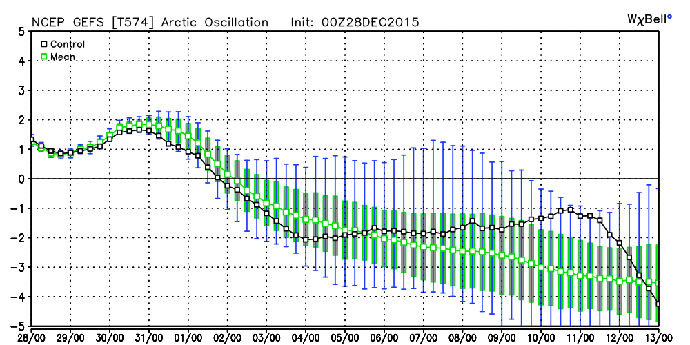
GFS Ensembles forecasting a tremendous drop in the Arctic Oscillation over the next week or two.
The combination of a -AO, -EPO, and +PNA has historically been a colder than normal grouping in the Northeast United States. The last chip to fall? The NAO (North Atlantic Oscillation). This also looks to trend negative with time, but may not fully do so until the stratospheric vortex is sufficiently dislodged or split.
Wrapping it all up…and getting it all ready
We’ll make one thing very clear: We fully anticipate a large-scale pattern change by the middle of January. This pattern change will support colder than normal air, and chances for wintry precipitation in the Northeast United States.
With all of this information in hand, it becomes important to maintain some perspective. While the pattern change looks nearly certain at this point, intricate details including the timing and duration of the change remains uncertain. Not surprisingly, understanding the potential for specific winter weather events at this juncture is nearly impossible.
Over the next week or so, however, things will become more clear; the details of individual storm systems may begin to come into focus.
Winter lovers, strap in.