-2")
Central US cooldown on the way, marking larger pattern change
The establishment of a large ridge over the Central and Eastern United States has been well documented. Since July, multiple surges of ridging have kept above normal temperature anomalies rooted from the Plains states through the Mississippi and Ohio River Valleys to the Eastern Seaboard. With varying degrees of intensity and length, these above normal anomalies have slowly taken a hit, lessening in intensity from west to east. This will take on a larger meaning this weekend, as a large trough drives into the Plains and Mississippi River Valley, bringing a widespread area of below normal temperatures into the Central US amid a changing pattern.
While temperatures won’t necessarily be “cold” by sensible weather standards, they will be a few degrees below normal in many locations, and several degrees below normal in some. This is statistically significant for this time of year, especially considering overnight temperatures could fall into the 50’s in many locations. When one considers the change in temperature from the past week, the significance becomes apparent — a 30 degree temperature differential in some locations.
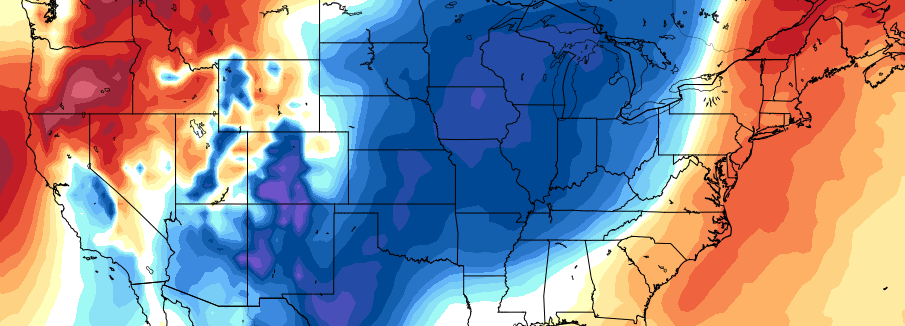
Forecast temperature departures for the week of August 21st throughout the United States
Two distinct areas of below normal temperature anomalies are likely to become established. The first will exist near the International Border and the Northern Plains. Here, deep troughs emanating out of Canada will result in below normal temperatures especially during the first half of the week of August 21st. The second below normal anomaly area is likely to exist from the Southern Plains to the Mississippi River Valley, where below normal temperatures will become established during the middle to latter part of the week.
Increasing moisture within this trough will also become a significant factor moving forward. Forecast models are good agreement on the idea that troughiness will take hold from the Northern Plains into the Mississippi River Valley, as mentioned. But there is also a stout signal for above normal precipitation, which when combined with already higher than normal soil moisture content could be beneficial to those areas which have not received much rain this summer.
The pattern looks to take on a different look the closer one gets to the Eastern Seaboard. Persistent ridging in the Western Atlantic will keep higher atmospheric heights in those areas — meaning any cold front or disturbance dropping southward out of Canada will have a difficult time making it there. Additional modification of those airmasses will keep temperature anomalies near or above normal, on average, throughout the period — although a few days of below normal temperatures aren’t out of the question.
The overall pattern looks to become established through at least the first few days of September. Forecast models and ensembles are in good agreement that, hemispherically, the support will continue for below normal temperatures in the above mentioned areas before any rebuilding of ridging, which is possible by mid September.
Are you interested in a preview of our Long Range/Agriculture and Trading Dashboard? Contact Us Now.